

My husband, Seamas, loves islands. He’s not alone, many people dream of living on or even owning their own private island. I just love looking at them and painting them. Which is handy, as the coastline of West Donegal is completely smothered with them. Looking out from the coast of Donegal, one of the longest in the country at more than 800 miles, is a bit like looking at the night sky and trying to name as many of the brightest stars as you can. Seamas seems to know most of their names without having to look at a map.

Around the coastline of the island of Ireland, there are 365 small islands, and a good number of those lie off the coast of Donegal. Wikipedia has individual pages for 20 of them, but there are many more than that. I can’t find an exact number. Many islands near the coast are little more than rocks big enough for some seaweed to cling to the edges of, visible only at low tide. Maybe these are just baby islands, islets. How big does a piece of land surrounded by water have to be to be an island, I wonder? If it’s big enough for some grass and a cow it must definitely be an island. There are quite a lot of those near Burtonport. The cows are well known for swimming between the island in search of better grass. I kid you not, it’s common off the coast of Inishcoo – click here for more evidence. I think the association between cows and island grazing is an ancient one as several islands take their names from cows, such as inishbofin (Inis Bó Finne) means island of the white cow and Calf island near Aran Island.
There are also about 100 sea stacks. Are these thin, vertical towers of rocks jutting out of the sea proper islands, I wonder? Slighter bigger and desolate are The Stags, or Stag Rocks, also known as The Three Sons of O’Gorra (Na Trí Mic Ó gCorra) which lie someway to the north of Owey island. Legend says that they were three pagan swimmers who were turned to stone by St. Colmcille the 6th Century missionary, also known as Columba.

Then there are islands that have (or used to have) people living on them. Arranmore is pretty big (8 square miles) and is home to a sizeable community of about 500 people full-time residents. Some islands are easy to get to, such as Cruit, which has road bridge to the mainland, and Arranmore and Tory which have a daily ferry. There are others that have only summer ferry such as Gola and Owey Islands.
There are a lot of islands with no ferry but can be reached relatively easily by boat or kayak such as Inishsirrer, Inishmeane, Edernish, Rutland, Eighter, Inishillintry, Inishinny, and Bo, Go and Allagh, Inishmeane, Inishdooey, Insihbeg, Inishfree Lower but are close-ish to the mainland, and others that are pretty remote, even to people with their own boats such as Umfin, Tororragaun and Raithlin O’Birne and then finally there are the very remote ones are Stags Rocks mentioned above and Roan Inish. Some like Arranmore and Tory are inhabited all year round, others like Owey and Gola are mostly home to people during the summer months.

I love the descriptive names of the islands thus Cruit (An Chruit) means harp-shaped, Owey (Uaigh) means cave as there’s one under the island, Island Roy (Oileán Ruaidh) means Red Island, Inisheeney (Inis éanaigh), bird island and Tory Island, (Toraigh) means High Tower and when you see photos of the island you understand why that is a good description of the island.

I have driven across the little bridge to long Cruit Island and I have boldly reversed my car onto the ferry to Arranmore and back again. I have spent a fair bit of time standing on the shore looking across the water at islands, Owey is a good example of this.


My latest subject for this mainland-based island-gazing is Gola. Its name sounds vaguely sporting, forever muddled in my mind with football and trainers probably because I used to have a pair of Gola gazelle trainers back in the 1990s. The island has nothing to do with trainers or goals. The name Gola, or Gabhla in Irish, means “forked”. If you look at a map of the island the name makes sense. The fork is the split in the west face of the island.

We set off on a sparkling afternoon in early April. The sun is out but it’s cold, with a chilly wind. I’d wear my big wooly hat in the car but the bobble on top is too big and it hits the headlining. So I drive without it on. In order to get to a good look at Gola, we drove past Donegal’s tiny airport at Carrickfinn, along a long single track road. There’s a lovely view of Mount Errigal off in the distance.


The track then rises and winds its way past a series of isolated houses, both and old and modern. The road is a bit threadbare in places, in good condition in others.


We follow the road until we reach a fine modern house overlooking what I’d call a beach, but this sort of long stretch of curving sand is known as a strand in Ireland. I think this is Dunmore Strand (An Tra Bhan). We climb out the car (I leave my window open in my excitement), with hat and gloves on and various cameras slung around our necks and stuffed in jacket pockets. The tide is out so that I don’t realize that the long stretch of dunes reaching to the north of me, is actually part of a tidal island, Inishinny.

The blond sand is strewn with majestic pink granite boulders and rocks. The clear sea is a most beautiful violet and turquoise. I have never seen anything quite like it. We spent a lot of time staring at the water, trying to fix its colour in our memories. The seaweed resting in between cracks in the rocks is a fantastic livid green.

Beyond the dunes is in the distance to the east is Gweedore and the village of Bunbeg and Magheraclogher beach. The terrain is peppered with lots of little white houses, most of them modern. In the opposite direction to the east is a very different landscape.

We have to walk along the sheltered beach and climb across a series of massive rocks to get a better look at the island. The island of Gola seems tantalizingly close, it’s only about half a mile. We can see the ruins of many houses, but also many painted white and with good roofs.

Seamas was very excited to see the island, as there is a possibility that his Donegal Coll forebears may have lived on the island. However, although we know his paternal grandmother originally from the Gaeltacht (Irish speaking area) somewhere in Gweedore, we cannot track her down in the records. There are lots of possibilities but no certainties.
Gola, is a small, very rocky and rather exposed-looking island. Mind you, I was looking at it from across the water, and it is consistently described as “beautiful” by visitors. The silvery quality of the light on the white-washed building nearest the shore certainly caught my eye. I tried to convey the quality of the light in my first painting of the island.
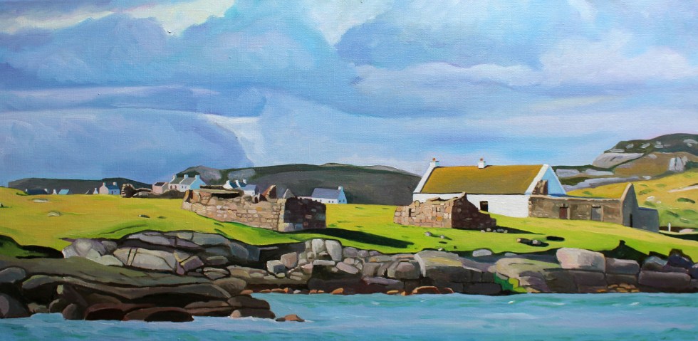
We then clamber across another set of massive pink granite rocks to the headland nearest the island. It is more exposed here. You can get a better look at the houses. I am fascinated by the ribbon of little white-washed houses that look out towards the mainland. They look they were positioned with the prevailing wind (blocked by the hill to the west of them) and company in mind. There is a larger modern house set back from the old cottages.
I wonder whether that belongs to one of the few full-time residents that live on the island. My second painting of Gola, I think give you a sense of just how rocky the island is. The hills and fields are peppered with boulders, rocks and stone walls. The coastline along the south side of the island is a rampart of geometric rocks. No wonder the little harbour is tucked in on the sheltered eastern side of the island.

The island is pretty small. It covers about one square mile (500 acres). Although it seems quite flat in comparison with Aranmore, it is “mildly hilly” on its west side, rising to 238 feet at Cnoc an Choillín and 212 feet at An Mhaol Mhór. These hills provided vital shelter for the houses that stretch along the east side. (Images taken from Google Streetview).


")
On the other side of the island is as statuesque sea-arch.

Gola was once inhabited by a surprisingly large community of over 200 souls. I looked across at this barren-looking land and wondered how on earth they could grow enough food to survive. Mind you, the land is not as bleak as the tiny fields of west Galway, full of stones. Yet survive they did, thrive even. Vegetables could be grown on the land fertilised with seaweed and turf could be cut from the bog to heat the homes. Many of islanders were fishermen and they would also travel to Scotland for seasonal to work each summer to supplement what they could grow on their small farms. Surprisingly, up until 1920s, the island population continued to grow, but it declined after 1930 and then became deserted in the late 1960s.
Yet, the island was never completely abandoned. Families would come and spend summer months here. Although most of the buildings on the island are derelict, many have been renovated by Gola families as holiday homes. The island now has mains electricity and water supply and a small number of people live on the island all year round.
Being an island the sea sustained island life but it also curtailed it. Bad weather could cut the island off from the mainland, especially in winter. The coast of Donegal frequently faces some very severe weather from the prevailing westerlies and the heaving Atlantic Ocean. Gola was immortalised in the sad lament “Baidin Fheilmidh” (Feilim’s little boat), a song about a Feilim’s bat which sets off for Gola and then Tory but was crushed against Tory island, sinking with poor Feilim in it. There are various versions of this song you can listen online including one by Sinead O’Connor but I think I like this paired back version best, which also has the lyrics in Irish & an English translation here.
There is a ferry service that runs from Bunbeg from June to September. Sabba, the ferryman, also runs facebook page under the name “Gola Ferry Service” and it it is a good idea to check before planning a visit.

We were too early in the year, sadly, to visit by boat. I am pretty sure that Seamas and I will be making a trip to Gola island in July when we are planning to be back in Donegal. We returned home to Burtonport for tea and biscuits to warm up in front of the fire.


Thank you for such and engaging tour of this part of the Donegal coastline. It looks marvellous. Another place to add to the ‘must see’ list.
Thank you, Leonie!
I like your photos and the videos you posted, but I find your paintings somehow capture even better the mood of the island.
Thank you, Hein. Although I work from photos I do try and recreate the sense of light and air about a place that is never in a photo.
How beautiful
Thank you, Ksbeth.
There is something magical about islands, and these are fantastic. Your paintings capture them so well ~ their rocky nature, the seas, the broad skies, the houses. Marvellous. (BTW,I was looking at the map on the sidebar and I was surprised to find out how ignorant of geography I was. I thought Ireland would be to the west of Wales, but in fact you travel north!)
Ah, yes, I can spent hours looking at maps and marvelling at how place aren’t where I think they are. When we caught the ferry at Fishguard in West Wales, it travelled west to Rosslare, so yes Ireland is to the west of Wales but most of it is north. Donegal is closer to Scotland than it is to Wales. Actually, in someways it closer to Scotland than Dublin as people travel and live in Donegal and Glasgow. Thus it has been for hundreds, if not thousands of years. These day people travel by plane and ferry in the past it would have been by foot and curragh (a sort of row boat).
I have never seen a cow swimming before. What beautiful country! We used to have a summer place in the Canadian Shield north of where we are not and we were on an island. Every year we would have some young buck white tailed deer on the island. They would swim from the mainland . I never thought anything of that but a cow swimming is a new one to me!
Its sounds like a wonderful place to spent the summer, Anne!
you always bring your own interpretation to these seascapes Emma! You make them your own.
Thank you, Wayne. I am always trying to recreate the light and wondeful sea air (it’s always windy, either a bit or a lot).
light is the most important element in art. The subject can vary but the light baths it.
What a great looking place, Emma! Thanks for the introduction, and I like both of your paintings very much. 🙂 🙂
Thank you, Jo. I am glad you like them.
Wat een bijzonder knappe rondleiingMoet fantastisch zijn daar te kunnen verblijven
Ja, we zullen zeker later in de zomer bezoeken.
Wow! This is so interesting. I would love to visit someday. Thank you for the tour. 😊
Thank you, Alexis.