


I have a confession to make. This walk was done out of sequence. It was done on March 28th, on the day the clocks went forward. That seems a long time ago. It was a beautiful day but very cold. Back in March when I had only got as far as Pennard and Three Cliffs, I sort of panicked. This was because I could not make head nor tail of the bus timetables and doubted that I could make it around the coastal path by public transport. So my husband, Seamas, suggested that we drive to the most out of the way places in Gower and do circular walks and then I would fill the rest in with public transport. Another blogger has since directed to the invaluable traveline.info which helped me made sense of the bus connections, when the online bus timetables seemed incomprehensible to me.
So we decided to go to Whiteford Point. It is a mini-peninsula off the northern corner of Gower peninsula. This is seen by many as the wildest and most remote part of Gower. We drove along the narrow lanes to the northern tip of Gower, to the village of Llanmadoc. Llanmadoc Hill is quite imposing as you approach it from the South East. I generally think of Gower as having two big hills (Cefn Bryn and Rhossili Downs) but Llanmadoc Hill at 152m is pretty high too. You get a sense of how it dominates this corner of the peninsula from Cedric Morris’s painting of it in 1928.

If you drive through the ajoining villages of Cheriton and Llanmadoc, you will come to Cwm Ivy Court Farm.

On the opposite side of the leafy lane is an open gate to a field, which acts as a temporary but well-used car park. When we arrive after lunch, it is pretty full. There is an honesty box built into the wall for walkers to put their car park fee of £1. Considering the National Trust charge up to £5 at Worms Head, it seem like a bargain.


We then walk down the lane past a small number of houses, the last one has a ice-cream tub of drinking water for passing thirsty dogs. Once you pass through the five-bar gate you are on National Trust land.


In 1953 it was designated a Site of Special Scientific Interest as it is an internationally important feeding ground for wading birds and wildfowl. Not long after in 1965, Whiteford Point came up for sale by auction and there was great worry that it might fall into the “wrong hands”. Fortunately, the National Trust was able to buy it. This was the first property to be acquired as a result of something called “Enterprise Neptune”, which was the National Trust’s campaign to protect Britain’s coastal heritage. So this area is a now a nature reserve owned by the National Trust.

If you follow the lane down hill there there is a choice.


Straight ahead is are the marshes and sands dune and eventually open beach that joins with the wide expanse of Broughton Bay, to the west. If you take a turn right through another wood gate you are then in Whiteford Burrows.

Whiteford (pronounced Whit-ford) is apparently derived from the Danish ‘Hvit-Fford’, meaning white ford. The Vikings left their mark on the outward-facing west coast of Gower, in their placenames at least. Look at left side of the map above. Worms Head, Burry Holmes and Whiteford are all derived from Scandinavian words. Perhaps, the Viking who traded and marauded up and down the Bristol Channel as late as the 11th Century, only ever gave names to the landmarks they could see from the water, but they certainly stopped by at Swansea, whose name is also Scandinavian in origin. It means “Swein’s Eye” or Island. There used to be an island at the heart of Swansea until the Victorian diverted the river. The Welsh call it “Abertawe” which means the mouth of the River Tawe.


Once into the the nature reserve you pass the very cute Burrows cottage, which used to be a forester’s cottage (you can rent it) and further along the path Cwm Ivy Bunk House (which you can also rent by the night). There are no other houses on Whiteford Point. It is a very lonely place from a human point of view. It is however, full of undisturbed wildlife.

Either side of the path are many grand pine trees, smothered with massive pine cones. They are Scots and Corsican pines. I think gives the place a Mediterranean air. They were planted from the 1930s onwards. There are hundreds them, thousands. I have read somewhere that there were 20,000 in the 1970s. They help certainly help stabilise the dunes and stop the sand blowing away. You can see these trees from miles around.

I get excited when I see what I think are public toilets in a very tasteful wooden chalet on the path ahead. I am always looking for “proper” places to relieve myself instead of the inevitable bushes.

Not toilets!
Ah, what a fool, I am. As I get closer I realise my mistake. Its not a nice artisan toilet block. It’s a bird hide for watching wildlife on the salt marsh to the right. The door is open and we can see its empty. So we go in and peer across the flat marsh. We don’t have the patience to wait.


[wpecpp name=”Woods at Whiteford Sands Large Mounted Print” price=”45″ align=”left”]
Once we have passed the bunk houses we follow a sort of path through the pine woods, climb a stile over a wire fence and we are on the burrows. Whiteford Burrows, or sand dunes, cover an area of three square miles. It’s bigger than it sounds. There is a vast expanse of beach on the other side of the dunes, leading out along the edge of the Loughor Estuary.


It was a long walk along the beach – it a very empty beach. Two miles of it to Whiteford Point. People are small dots off in the distance.

The landscape here is reduced to stripes of colour: Sky-sea-beach-dunes. The tide is out and the sea is very distant.

I am slightly unnerved by the signs saying informing me that Burry estuary was used as a shelling range by the British army during World War Two and the unexploded bombs are still likely to turn up in the sand dunes. Yikes! I take this seriously, I remember a World War Two bomb that was recently found in the near by Loughor River although I can’t find the story online. In 2015 a family found what they thought was a “buoy” covered in barnacles on the northern side of the estuary, at Burry Port. The kids spent quite a bit of time jumping on the strange object and had their picture taken next to it. You have probably guessed it by now. It wasn’t a buoy it was an old Second World War bomb. The beach was cleared and the “buoy” was blown up.

Shells still turn up at Whiteford Point too. In September 2014, for example, some sixty shells were exposed at Whiteford Point, and bomb disposal teams were summoned to deal with them. The firing range was also used on a regular basis for the firing of chemical shells during the Second World War, including ones containing mustard gas. Earlier this year there were reports of the Ministry of Defense blowing “something” up earlier this year in the Loughor Estuary so I don’t fancy taking my chances and stick to the beaches. I expect most people do the same and the dunes are left undisturbed.

At Whiteford Point there is a curious cast-iron light house. It is the only wave-swept cast-iron tower of this size in Britain.

It reminds me of a giant bird cage. The local seabirds, gulls and cormorants use it as a convenient perch. It is not close to the beach but it can be reached at low tide, although its a long rocky walk over the seaweed-covered rocks.

[wpecpp name=”Wave-Swept Iron Tower Large Mounted Print ” price=”45″ align=”left”]
It reminds me that much of the Gower coast was always hazardous to shipping. This area in particular was very treacherous and a large number of ships were wrecked at both nearby Broughton Bay (where ships used to be able to anchor in the bay until it was silted up in mid-nineteenth century) and here along Whiteford Sands.
Tragically, the lighthouse failed to prevent a one of the biggest shipping disasters in the area, which took place in January 22nd 1868. On this calm winter night 16 ships out of a fleet of 19 sailing out of Llanelli, sunk in a single night and possibly up to 30 or more lives were lost. These ships had been towed out of Llanelli by steam tugs. They had been cast off and rounded Whiteford point, aiming to clear Burry Holmes with the ebb tide. This was in the age of sail and the ship needed a breeze to power them on their way.
Unfortunately, the wind died and a heavy swell tore the ships from their anchors and drove many of the ships onto the rocks at Broughton Bay, or smashed them against each other. As it was such a quiet night, no one on shore had any idea of the disaster that was happening in the estuary. A large buoy and chain and the remains of a wooden hull near Whiteford Point are all that is left of these ships.

Although the beach seems utterly deserted the air is filled with the high pitched piping sounds of little wading birds.

They are too far off to identify with any certainly, but I think they might be oyster catchers. We are feeling tired after our long walk along the beach. We sit on the edge of the dunes for a rest and chocolate biscuits, listening to the euphoric trilling of skylark song.

Around the tip of Whiteford Point the path reappears and winds its way along the edge of the pine woods. The path is very water logged and at many points it resembles a series of small still lakes rather than a path. So we hop from muddy patch to muddy patch.
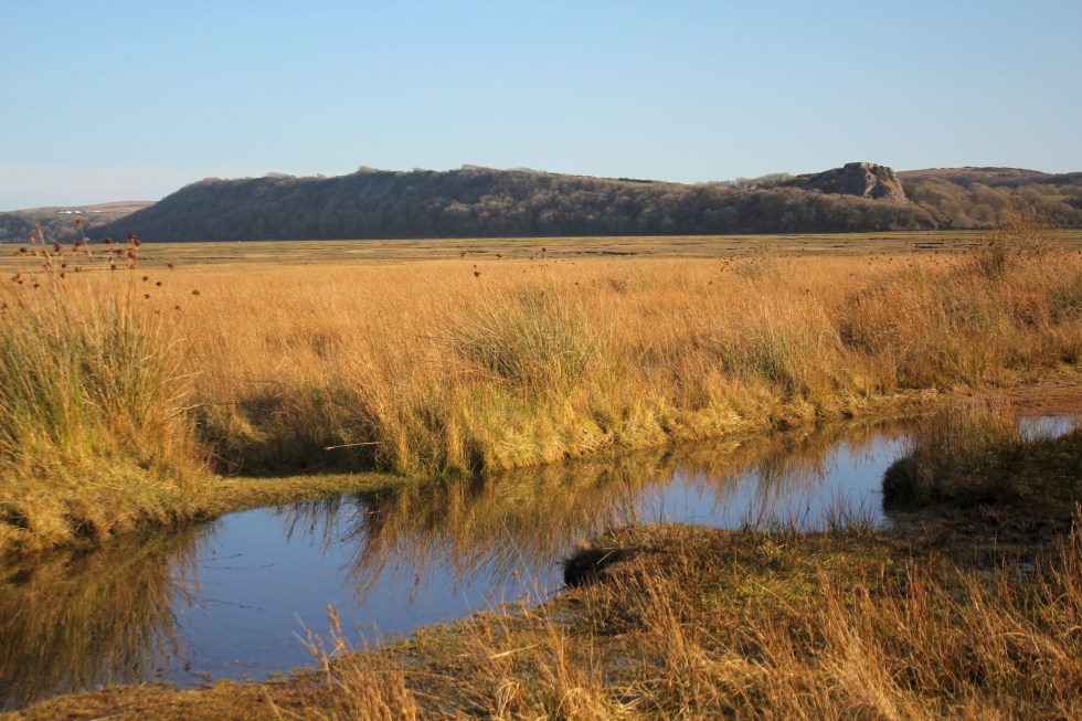
Here there is lots of bird song – blackbirds, ravens, rooks and we saw linnets, larks and tiny robins. On this side of Whiteford Point, it is very flat marshland. The sea is but a distant memory. This is clearly a river estuary and the river is far off beyond clumps of pine trees. The marshes are covered in lush grass and edged by yellow reeds. There are shaggy marsh ponies, who seem very small in comparison to their cousins who graze on Cefyn Bryn and Fairwood Commons.


As we get closer to Cwm Ivy, our starting point, we can see the village Llanmadoc spread up the hillside. We pass the late Medieval sea wall. There has been a sea wall at Cwm Ivy since the late 17th century when it was used to reclaim the marshland from the sea. The coastal path used to follow the wall round to Llanmadoc. Not any more, not since 2014 when the wall was breached by storms. The Welsh Government Shoreline Management policy stopped the National Trust from repairing the wall and breech. This ‘No active intervention’ policy of letting nature take its course was a controversial decision at the time. So this fresh water marsh has now returned to being a salt marsh. The breach is too big to jump over, there’s no bridge so you have to take a diversion at Cwm Ivy to reach the rest of old coastal path (which we did on another day).


The walk took us three hours, but as much of it was on sand so it was pretty tiring. We only took 4 biscuits with us, thinking that our lunch would see us through. I decided that I should have taken a couple of bananas and sandwiches too as you always need more food than you think you will need. If you don’t eat them I know of two helpers who will happily finish them off for me.

Next week: My final very long walk around the Gower Coastal Path.
[maxbutton id=”5″ ]

I love that you know this landscape so well, Emma, and put in the time to research the history. I always know that I am going to find a treasure trove of interesting information, as well as beautiful photos and pictures. Thank you!
Thank you Ali, I used to be a Historian so I can’t help but dig a little deeper into the landscape I see around me.
Ah! That completely makes sense now!
Yep. I’ve been rumbled. I can’t help but find out about a landscape’s past. It deepens the relationship for me.
So enjoying your posts of the Gower peninsula…………makes me want to pack a bag and venture over there….
It is fabulous at this time of year – there’s so many different landscapes in a small peninsula. It’s only 16 miles long!
It was your exceptional painting of the lighthouse that drew me in from Twitter. But then I saw the gorgeous sky above the dunes, the lovely animals and the wonderfully named “honesty box”. For some reasons I don’t believe it would quite deserve to be called this around here. And I love the Cedric Morris painting too. What, only one more post and you’ve done it all?
I know, it’s sad isn’t it.?I wish I could go on and walking and writing and painting. I’ll have to work out the best way to turn this into a little book and do print on demand. I am going crazy trying to work out the best POD company that doesn’t charge ridiculous postage (which is what the Americans ones like Blurb and Lulu seem to do). I am open to suggestions.
Another enjoyable walk. The history is fascinating. Thanks
You are welcome
[…] Gower Coastal Walks: Whiteford Point […]
Another fascinating post, Emma! I enjoyed reading it and viewing your photos, and your paintings, especially the Wave-Swept Iron Tower!
Lighthouses are fascinating places and tgis iron one really caught my imagination. Thank you for your comment, Hein.
That cast iron lighthouse is very striking, Emma. Shame it wasn’t entirely successful. I like the contrast in styles of the way artists portray landscapes. 🙂 🙂
I don’t think having a light house in the estuary made any difference to that particular disaster but it would have helped save other lives.
It’s aesthetically pleasing too, isn’t it? 🙂
What a lot of beautiful places yoy find there
Thank you, Marylou.
[…] leaves. I also love the scotch pines that pepper the Gower peninsula. There’s a woodland at Whiteford point and also near Parkmill, which I have returned to time and again to […]