I am delighted to announce the publication of my latest book “Footnotes, An Artist’s Journey Around the Gower Coast” which is based on my walks and blogs of 2018.
My book on Medieval History
Many years ago I turned my Ph.D. on Medieval History into an academic book. That was jammed packed with footnotes and had almost no pictures (except for the front cover) but it did have some maps hand-drawn by me. I felt quite odd when that was published. I suffered terribly from imposture syndrome, then as now, and it almost felt like someone else had written it when I looked at the words on the book. Don’t get me wrong, I had written every last bit of it, the text, the footnotes, the index but it didn’t feel like it had much of “me” in it, except maybe in my dedications. I think my parents and Seamas, who was my boyfriend back then, appreciated being thanked for their support.
This book is quite different. Ironically, despite the name, the only “footnote” in it is the title. It’s a bit of a joke, I guess! This book has a lot more of “me” in it. Yes, there still some local history and stories about Gower, but its mostly about the walk and dealing with my anxieties.
I had spent weeks editing it and sort of ran out of steam when I reached the part where I had to upload it to the Kindle website. Thankfully, my husband, Seamas, came to rescue and was midwife to the whole venture. He did the final editing and proof-reading and it uploaded to the website. Which sort of sums up our relationship, he’s always there to help me over the “humps”, not just as a cheerleader but as technical support and he also provides so much inspiration. So thank you, Seamas.
I also want to thank my parents who have always supported whatever I have done. My mother is a fervent “liker” on Facebook. Their house has many of my paintings hanging on their walls, which is a compliment in its self as superfluous objects are either returned to the donor or end up in the local Charity shops. I also want to thank supporters on Instagram who tell me that they have downloaded from Kindle or bought the physical book.
I hope that people enjoy it as much for the walks and stories about Gower, as for my paintings!
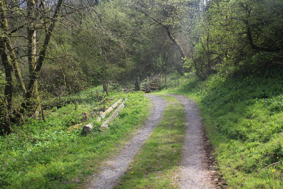
This is the last stretch of my walk around the Gower coastal path. I started this particular walk at Llanmadoc, which is three miles along a generally flat, but not always obvious, grassy and often muddy path.
Path to Llanrhidian
As I approach Llanrhidian, the atmosphere changes from rural scruffiness to urban tidiness; where the grass is kept short by electric mowers rather than by sheep. I pass along a path with a wooden fence along the one side. This seemed a bit of a shock after all the open spaces.
Llanridian itself is picturesque. It feels very much like a village that has been here for hundreds of years.
There is a unique church dedicated to Saints Illtyd and Rhydian in the village. The village that grew up around the 6th century church was founded by St. Rhidian, hence it’s name – “Llan” (meaning religious enclosure) “Rhydian” (the founder’s name). Rhydian dedicated the church to St Illtyd, another Celtic saint who was believed to have lived here. You may remember St Illtyd, he was the Celtic founder of the sea-side church at Oxwich and has many churches dedicated to him across Gower and South Wales.
Llanridian Church
The church that exists in the village today was built in 14th century. It has a holy well and something known locally as a “leper stone”, as well as a 11th century wheeled cross shaft near it.
Remains of Wheeled Cross
The so-called leper stone is a probably the remains of a door lintel, or maybe even or tombstone lid and dates from the 9th century. I probably did not have any connection with lepers was, other than in the imaginations of the Victorian who discovered it near the west tower doorway it in 1865 and subsequently had it moved to the church porch.
Leper Stone, Llanridian Church
According to tradition, when St. Illtyd lived on this spot as hermit, the sea often flooded the site, destroying the saint’s cell and chapel. Several times he built an embankment of mud and stones to protect himself, but in vain. He asked an angel to help him and the sea obeyed the saint, subsiding. He then struck his crozier on the dry shore and a holy well gushed forth, instantaneously. This well still flows today and is said to have curative properties. It is located in a private garden near the Church. It also known as the “milk well” or “butter well” , by locals, as in 1185 milk and butterfat was seen flowing in it instead of water, according to the Annals of Margam. This miraculous event was said to have lasted for at least three hours.
Here I joined the coastal road. The atmosphere changes back to the marsh wildness with the mild peril of possible flooding.
Flooding Warning Sign, Llanridian Marsh
It the only true coastal road on Gower. It skirts along the side of the wide marsh from Llanridian to Crofty.
Crofty in the distance
I could see Crofty off in the distance, but I wasn’t going to be fooled into thinking it was close because I could see it. I can see Port Talbot from Swansea Beach, it’s still 13 miles away an in no sense “close”. Same goes for Crofty. Turns out its three miles from Llanridian, which was possibly further than I realised when I decided to trudge it’s length. It figured, its flat. It’ll be easy!
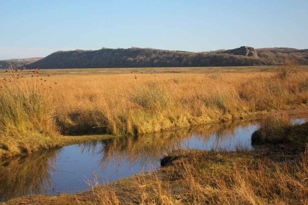
The Marsh, North Gower
Well it was flat but it was also a very long road. It was a very empty road. I passed only three cars/vans and one cyclist in the two hours I was walking on it. The cyclist nearly ran into me when I walked into his path.
Lone Cyclist
I was my fault as I didn’t look over my shoulder when I heard a noise behind me, but I was very tired at this point.
Pergyl! Danger!
I stopped several times to take photos and enjoyed watching the light change as the clouds moved above my head. It may seem to strange to say, that this was probably my favourite part of all my Gower walks. Strange, it was very beautiful but I decided that I wasn’t going to paint this landscape. It’s too flat for my painting tastes. Maybe that’s why I enjoyed it all the more. It’s even hard to capture its essence in a photograph.
Llanridian Marsh
I haven’t attempted to paint it but I loved the sense of wilderness here that it’s present anywhere else along the Gower coastline.
Marsh Road, North Gower
At one point there must have been a lull in the cold wind and a silence fell and then I heard a rustling in the trees and bushes behind me and then a moment later, I felt its force. It was rather eerie to feel the force of nature.
Llanridian Marsh
Off in the distance was an aeroplane circling round and round the estuary off over Burry Port where Amelia Earhart landed all those years ago. Amelia was the first woman to fly (or be flown) across the Atlantic Ocean in 1928, when she flew across the Atlantic, this time as the pilot and on her own, four years later she landed in Northern Ireland.
I finally reached the village of Crofty.
Crofty, North Gower
It had a distinctly urban feel to it, not like Llanrhidian. By now had drunk both of my 500l bottles of water. I had very sore and stiff legs but I forced myself the trudge with purpose because I knew that I had about 20 minutes to make it to “New Road”, the main road, and catch the bus back home.
As I cut through the streets of Crofty, the roads all seemed unreasonably long but I eventually found the main road and I started walking in the direction of Llanridian. A bus shelter stop appeared.
A Miracle!
It seemed like a miracle to my tired legs. A bus appeared – a number 116 it its distination read “Llanridian” and not Swansea. I was so excited to see a bus with the number I was looking for I hailed it. The rotund bus driver looked at me slowly. No, this wasn’t the bus to Swansea. The stop for that was on the other side of the road. I looked across the road. So he pulled off and I crossed to the other side of the road, although there was no bus shelter or bus sign there. So I waited and waited. After about ten minutes, a school bus pulled up and some street-wise-looking teenagers got off. None of them looked like they were rushing home to do their homework.
Eventually, after I started wondering if Crofty had a taxi service or I’d have to stumble another two miles up the road to Penclawdd, a number 116 bus appeared. It said Swansea on the front. The bus indicated that it was stopping before I put out my hand to hail it. That was handy, I thought. I stepped onto the bus to show the driver my return ticket and as I glanced into his sour face, I realised that he was the same bus driver I spoke to twenty minutes earlier. Not a flicker of recognition passed over his face. I walked to the my seat, glad to sit down after 4 hours walking, chuckling to myself.
I had covered 6 miles and my feet were throbbing. It was a funny end to the walk. I had not seen the sea or river all day but I had smelt the salt and felt the wind. I had hardly seen a soul. It certainly the wildest and flattest part of the coastal path. I was glad it was over and my challenge was finally complete, Well, almost.
Post Script
This isn’t quite my last Gower coastal walk. I haven’t walked out along the causeway to Worms Head. However, you cannot climb to the top of the outer headland between the 1st March and the 31st of August – as it is closed in order to protect the many breeding sea birds, so I am waiting until September to do this final walk.
Below is a short video clip of the marshes near Llanmadoc. I’m afraid its rather poor, turn off the sound, but it’ll give you a good sense of of how vast and flat the marshes are.
I have a confession to make. This walk was done out of sequence. It was done on March 28th, on the day the clocks went forward. That seems a long time ago. It was a beautiful day but very cold. Back in March when I had only got as far as Pennard and Three Cliffs, I sort of panicked. This was because I could not make head nor tail of the bus timetables and doubted that I could make it around the coastal path by public transport. So my husband, Seamas, suggested that we drive to the most out of the way places in Gower and do circular walks and then I would fill the rest in with public transport. Another blogger has since directed to the invaluable traveline.info which helped me made sense of the bus connections, when the online bus timetables seemed incomprehensible to me.
So we decided to go to Whiteford Point. It is a mini-peninsula off the northern corner of Gower peninsula. This is seen by many as the wildest and most remote part of Gower. We drove along the narrow lanes to the northern tip of Gower, to the village of Llanmadoc. Llanmadoc Hill is quite imposing as you approach it from the South East. I generally think of Gower as having two big hills (Cefn Bryn and Rhossili Downs) but Llanmadoc Hill at 152m is pretty high too. You get a sense of how it dominates this corner of the peninsula from Cedric Morris’s painting of it in 1928.
If you drive through the ajoining villages of Cheriton and Llanmadoc, you will come to Cwm Ivy Court Farm.
Far Hill Above Cheriton, 2016 (SOLD)
On the opposite side of the leafy lane is an open gate to a field, which acts as a temporary but well-used car park. When we arrive after lunch, it is pretty full. There is an honesty box built into the wall for walkers to put their car park fee of £1. Considering the National Trust charge up to £5 at Worms Head, it seem like a bargain.
We then walk down the lane past a small number of houses, the last one has a ice-cream tub of drinking water for passing thirsty dogs. Once you pass through the five-bar gate you are on National Trust land.
In 1953 it was designated a Site of Special Scientific Interest as it is an internationally important feeding ground for wading birds and wildfowl. Not long after in 1965, Whiteford Point came up for sale by auction and there was great worry that it might fall into the “wrong hands”. Fortunately, the National Trust was able to buy it. This was the first property to be acquired as a result of something called “Enterprise Neptune”, which was the National Trust’s campaign to protect Britain’s coastal heritage. So this area is a now a nature reserve owned by the National Trust.
Whiteford Point
If you follow the lane down hill there there is a choice.
Straight ahead is are the marshes and sands dune and eventually open beach that joins with the wide expanse of Broughton Bay, to the west. If you take a turn right through another wood gate you are then in Whiteford Burrows.
Pine Trees
Whiteford (pronounced Whit-ford) is apparently derived from the Danish ‘Hvit-Fford’, meaning white ford. The Vikings left their mark on the outward-facing west coast of Gower, in their placenames at least. Look at left side of the map above. Worms Head, Burry Holmes and Whiteford are all derived from Scandinavian words. Perhaps, the Viking who traded and marauded up and down the Bristol Channel as late as the 11th Century, only ever gave names to the landmarks they could see from the water, but they certainly stopped by at Swansea, whose name is also Scandinavian in origin. It means “Swein’s Eye” or Island. There used to be an island at the heart of Swansea until the Victorian diverted the river. The Welsh call it “Abertawe” which means the mouth of the River Tawe.
Once into the the nature reserve you pass the very cute Burrows cottage, which used to be a forester’s cottage (you can rent it) and further along the path Cwm Ivy Bunk House (which you can also rent by the night). There are no other houses on Whiteford Point. It is a very lonely place from a human point of view. It is however, full of undisturbed wildlife.
Either side of the path are many grand pine trees, smothered with massive pine cones. They are Scots and Corsican pines. I think gives the place a Mediterranean air. They were planted from the 1930s onwards. There are hundreds them, thousands. I have read somewhere that there were 20,000 in the 1970s. They help certainly help stabilise the dunes and stop the sand blowing away. You can see these trees from miles around.
The pine trees as Seen from Hills Tor
I get excited when I see what I think are public toilets in a very tasteful wooden chalet on the path ahead. I am always looking for “proper” places to relieve myself instead of the inevitable bushes.
Not toilets!
Ah, what a fool, I am. As I get closer I realise my mistake. Its not a nice artisan toilet block. It’s a bird hide for watching wildlife on the salt marsh to the right. The door is open and we can see its empty. So we go in and peer across the flat marsh. We don’t have the patience to wait.
[wpecpp name=”Woods at Whiteford Sands Large Mounted Print” price=”45″ align=”left”]
Once we have passed the bunk houses we follow a sort of path through the pine woods, climb a stile over a wire fence and we are on the burrows. Whiteford Burrows, or sand dunes, cover an area of three square miles. It’s bigger than it sounds. There is a vast expanse of beach on the other side of the dunes, leading out along the edge of the Loughor Estuary.
It was a long walk along the beach – it a very empty beach. Two miles of it to Whiteford Point. People are small dots off in the distance.
Whiteford Sands (towards Broughton Bay)
The landscape here is reduced to stripes of colour: Sky-sea-beach-dunes. The tide is out and the sea is very distant.
Whiteford Sands
I am slightly unnerved by the signs saying informing me that Burry estuary was used as a shelling range by the British army during World War Two and the unexploded bombs are still likely to turn up in the sand dunes. Yikes! I take this seriously, I remember a World War Two bomb that was recently found in the near by Loughor River although I can’t find the story online. In 2015 a family found what they thought was a “buoy” covered in barnacles on the northern side of the estuary, at Burry Port. The kids spent quite a bit of time jumping on the strange object and had their picture taken next to it. You have probably guessed it by now. It wasn’t a buoy it was an old Second World War bomb. The beach was cleared and the “buoy” was blown up.
That’s NOT a buoy!
Shells still turn up at Whiteford Point too. In September 2014, for example, some sixty shells were exposed at Whiteford Point, and bomb disposal teams were summoned to deal with them. The firing range was also used on a regular basis for the firing of chemical shells during the Second World War, including ones containing mustard gas. Earlier this year there were reports of the Ministry of Defense blowing “something” up earlier this year in the Loughor Estuary so I don’t fancy taking my chances and stick to the beaches. I expect most people do the same and the dunes are left undisturbed.
Beware Unexploded Shells!
At Whiteford Point there is a curious cast-iron light house. It is the only wave-swept cast-iron tower of this size in Britain.
Whiteford Lighthouse
It reminds me of a giant bird cage. The local seabirds, gulls and cormorants use it as a convenient perch. It is not close to the beach but it can be reached at low tide, although its a long rocky walk over the seaweed-covered rocks.
[wpecpp name=”Wave-Swept Iron Tower Large Mounted Print ” price=”45″ align=”left”]
It reminds me that much of the Gower coast was always hazardous to shipping. This area in particular was very treacherous and a large number of ships were wrecked at both nearby Broughton Bay (where ships used to be able to anchor in the bay until it was silted up in mid-nineteenth century) and here along Whiteford Sands.
Tragically, the lighthouse failed to prevent a one of the biggest shipping disasters in the area, which took place in January 22nd 1868. On this calm winter night 16 ships out of a fleet of 19 sailing out of Llanelli, sunk in a single night and possibly up to 30 or more lives were lost. These ships had been towed out of Llanelli by steam tugs. They had been cast off and rounded Whiteford point, aiming to clear Burry Holmes with the ebb tide. This was in the age of sail and the ship needed a breeze to power them on their way.
Unfortunately, the wind died and a heavy swell tore the ships from their anchors and drove many of the ships onto the rocks at Broughton Bay, or smashed them against each other. As it was such a quiet night, no one on shore had any idea of the disaster that was happening in the estuary. A large buoy and chain and the remains of a wooden hull near Whiteford Point are all that is left of these ships.
Although the beach seems utterly deserted the air is filled with the high pitched piping sounds of little wading birds.
They are too far off to identify with any certainly, but I think they might be oyster catchers. We are feeling tired after our long walk along the beach. We sit on the edge of the dunes for a rest and chocolate biscuits, listening to the euphoric trilling of skylark song.
Around the tip of Whiteford Point the path reappears and winds its way along the edge of the pine woods. The path is very water logged and at many points it resembles a series of small still lakes rather than a path. So we hop from muddy patch to muddy patch.
Looks like a lake but its the path!
Here there is lots of bird song – blackbirds, ravens, rooks and we saw linnets, larks and tiny robins. On this side of Whiteford Point, it is very flat marshland. The sea is but a distant memory. This is clearly a river estuary and the river is far off beyond clumps of pine trees. The marshes are covered in lush grass and edged by yellow reeds. There are shaggy marsh ponies, who seem very small in comparison to their cousins who graze on Cefyn Bryn and Fairwood Commons.
Weobley Castle in the distance
As we get closer to Cwm Ivy, our starting point, we can see the village Llanmadoc spread up the hillside. We pass the late Medieval sea wall. There has been a sea wall at Cwm Ivy since the late 17th century when it was used to reclaim the marshland from the sea. The coastal path used to follow the wall round to Llanmadoc. Not any more, not since 2014 when the wall was breached by storms. The Welsh Government Shoreline Management policy stopped the National Trust from repairing the wall and breech. This ‘No active intervention’ policy of letting nature take its course was a controversial decision at the time. So this fresh water marsh has now returned to being a salt marsh. The breach is too big to jump over, there’s no bridge so you have to take a diversion at Cwm Ivy to reach the rest of old coastal path (which we did on another day).
The walk took us three hours, but as much of it was on sand so it was pretty tiring. We only took 4 biscuits with us, thinking that our lunch would see us through. I decided that I should have taken a couple of bananas and sandwiches too as you always need more food than you think you will need. If you don’t eat them I know of two helpers who will happily finish them off for me.
Biscuit? Yes please!
Next week: My final very long walk around the Gower Coastal Path.
This is the most challenging leg of my journey around the Gower coast, thus far. It is the longest walk I have done so far at 6 and a half miles. For some reason, I keep thinking its much further than that. I had convinced myself that it was 8 miles. It felt like that.
I have been obsessing over the bus timetables and the information I have garnered from Traveline.com which makes sense of the bus connections for me. I have written all the available buses in my note book which I carry in my rucksack as well as on a cheery yellow post-it note which I have in my coat pocket. I have tried very hard not to think of all the things that could go wrong but at 4 am I have persistent visions of twisted ankles and buses not turning up. I pack two plasters although I suspect they won’t be massively useful if I do twist my ankle. Yet, it seems that I have done all my worrying in advance for once I set off everything pretty much goes without a hitch.
It is a warm day. I am wearing my light padded jacket for the first time this year. My rucksack, which is actually my husbands old laptop rucksack, contains the following:- Water bottle; food – sandwiches, banana, biscuits; bus timetables for all Gower buses; tide timetable; two plasters; spare socks; camera; handbag. Somehow I haven’t organised myself enough to leave my stupid handbag behind. I know it has many useful things in it like a tape measure, make-up mirror, phone, fold away shopping bags, but I suspect it adds a fair bit of weight.
I dont have to wait long for the number 118 bus to arrive on Gower Road in Swansea. The bus driver blinks at me slowly when I ask “Change at Scurlage?” This is the first time I have been on a NAT bus. That stands for National Adventure Travel. As a car driver, travelling on a bus has a certain amount of novelty for me and looking out the grimy windows is almost a treat! This bus is OK but not as nice as the city First Cymru buses. Buses seem like things of the city to me (I am a townie born and bred) but once we rattle over the cattle grid at the edge of Fairwood Common and leave Swansea behind, there are great views across the common towards Cefyn Bryn, the long hill that extends across Gower. I enjoy the superior height of the bus which means I can look over walls and into people’s gardens as they flash by.
It is high tide as Three Cliffs Bay as we pass, a sight that gives me a small thrill. We pass the campsite at Nicholston and two walkers, a man and woman, get on. I have company. They both have rucksacks. I wonder why they have one each. They can’t both have handbags in there!
Scurlage. Thankfully the connection is waiting. We climb down from our big bus and into the smaller bus with hard seats and a sunroof.
It takes a long and winding route, pause for 3 minutes in a lay by, and then on to Horton, past a vast caravan park and eventually down a steep hill past the church and into Port Eynon.
Chips at Port Eynon
Port Eynon on a long sandy bay on the South coast of the Gower Peninsula. It is the second largest “indentation” on the coastline. Truth be known, it is my favourite Gower place to visit in summer because it always has plenty of space on the beach, a shallow sea which warms up in the British sun and a wonderful gift shop full of the sort of junk that is absolutely necessary on a beach holiday (kites, snorkels, body boards, flip-flops, rock, postcards), a surf shop, ice cream kiosks and best of all not one but two fish & chip shops. Oh, and there’s a couple of pubs too if you like that sort of thing. Have I made it sound commercial and tacky?
Last Swim of the DayOne of Port Eynon’s two fish & Chips shops
Well, you’d be wrong because almost nothing on the Gower peninsula is allowed to be commercial and tacky. I say almost nothing because I can’t think of anything at the moment that could be desribed as such, but someone may point out somewhere I have forgotten. Much of that is thanks to the wonderful Gower Society. If you have visited Gower you might think that the Gower Society have just put up some markers stones for their “Gower Way” which snakes across the inland sections of the Peninsula but not a lot else.
Gower Society Stone Marker
You would be very wrong. The Society was founded in 1947 by a group of Gower enthusiasts who were originally interested in the Peninsula’s history but soon became involved defending Gower from developers and preserving its natural heritage. I came across a copy of a book about the Gower Society in the excellent Oxfam shop in Swansea town. It’s called “The First Sixty Years” by Ruth Ridge. When I read it I was totally in awe of the tireless work they have done. Here’s a just a few short list of their many achievements
Successfully campaigning for Gower to be recognised as the UK’s Area of Outstanding Natural Beauty (AONB) in 1956
Part of the campaign that successfully fought off a Butlin’s-type holiday camp at Rhossili
Limited and monitored the number and size of caravan sites on Gower
Produced lots of excellent and very affordable guide books on Gower walks, plant life, castles and caves.
Prevented the building of a cliff railway and zoo at Rhossili
Prevented the construction of wind turbines on the Peninsula.
Campaigned against sand dredging in the Bristol Channel
Helped preserve and partially restore the iron lighthouse at Whiteford Point.
Raised money to purchase numerous tracts of land and donated them to the National Trust e.g. Worms Head and Pennard Cliffs and also to the Glamorgan Wildlife Trust e.g. Overton Cliffs.
Raised concerns and gave grants to help restore and maintain many important Historical buildings such as Oxwich, Pennard, Oystermouth Castles and the Salt House at Port Eynon.
There is loads more they have done to protect and preserve Gower but I thought I’d just give some highlights.
Port Eynon or Porteynon takes its name from a Welsh prince, Einion, of the 11th century who is meant to have built a “castrum“, a castle or fortified house here. There is no sign of the castle except for its church, St. Cattwg’s, and its dovecot, the extraordinary Culver Hole built into the nearby seacliffs. In Victorian times the village supported itself by Oyster-fishing from September to March and in the summer by limestone quarrying. Ships from Devon crossed the Bristol Channel to pick up the Port Eynon limestone. The trade in Oysters died out in the 1870s, over-fishing seems to have killed it off.
The Church was founded by a missionary saint in the 6th century but the building that stands in the village today is almost all the result of Victorian “restoration”. It is claimed that the church was used as hiding place for smuggled goods around the time of the battle of Trafalgar, kegs of booze being hidden in the altar, and at other times, the goods were buried in the sand-dunes.
In the churchyard is a distinctive looking memorial to three Port Eynon lifeboat men who lost their lives in a terrible storm in the winter of 1916. It may seem odd that the village of about only 500 people felt the need to erect a memorial to the three local men who died at sea when thousands of young men were being killed in far away places like France and Belgium in World War One, but the body of Billy Gibbs, the coxswain was never recovered. This was very much like the experience of families elsewhere in the country who never saw the bodies of their loved ones again. So the local community had a life-sized statute of Billy Gibbs built as a memorial to the sacrifice of all three men.
The Lifeboat Memorial
The Lifeboat House is now the Youth Hostel. Only one of two on the Gower. As it was low tide I walked across the beach to the Youth Hostel.
On the other side of the hostel are the ruins of something called the “Salt House“. Some these walls were part of Victorian oystermen’s cottages. The main building, however, was used for salt production from the 16th to around the mid-17th centuries. The site was chosen for the high salinity of the bay with little fresh water contamination. The sea water would enter the beach chambers at high tide where it would be stored in a reservoir. The water would be pumped into large iron pans and slowly heated and evaporated. As the salt formed it would be scooped off and stored in the northern part of the main building to dry. Salt was a very valuable commodity, shown by the fact the site was enlarged and fortified during the 17th century, with the inclusion of musket loops within the thick walls.
Salt House
There was plenty of tall stories about a couple of outlaws called John Lucas, who were pirates and smugglers. The first John Lucas supposedly fortified Culver Hole in the 16th century, hid his loot in there and visited it via an underground passage, although there is little evidence of this. Seven generations later another John Lucas fortified the Salt House and started a smuggling empire. Some people have claimed that John was a Welsh Robin Hood, stealing from the rich and giving to the poor. Sadly, these interesting stories seem to have been totally all made up. This set of nonsense was made up by Rev. Dr. J.H. Spry during the 1830s in a dispute over property. Fake news, we’d call it today. It seems that people have been faking stuff long before the internet was even dreamt of.
Old Life Boat Station now YHA
The coastal path runs along the nearside of the Youth hostel.
Up a steep path past disused limestone quarries.
There are wonderful views of the bay to the east.
Salt House at Port EynonThe Salt House and Salt House Mere (to the right)
After climbing more steep path there is a great view of the sea to the east. This is Port Eynon Point. It is a nature reserve looked after by The Wildlife Trust of South & West Wales. Part of the cliff top was once ploughed during the Second World War but there is no sign of it now. This area is a nature reserve looked after by The Wildlife Trust of South & West Wales. In fact the whole South Gower Coast from here to Rhossili (Pilton Green) is a SSSI (Site of Special Scientific Interest) which is a term or designation given to an area in the UK which is protected for conservation. It is owned by the National Trust and managed by the Wildlife Trust of South and West Wales.
If you follow the path northwards you come down a steep hill, past more disused limestone quarries towards Overton Mere.
Overton Mere is a wide bay of limestone rocks, rock-pools, shingle and a few tiny patches of sand. On the eastern side of the bay and about 200 yards west of the point, is Culver Hole – mentioned earlier – the dovecot made from a narrow cave sealed off by a 60 foot high wall. I thought about visiting it but after edging my way along the cliff-edge path for 10 minutes I lost my nerve and decided that should save my energy for the long walk to Rhossili.
Although the tide was out, the waves were very high, this morning, 5 or 6 foot high. All along this stretch of coast I was accompanied by the booming waves as they broke on the shore. Every now and then, as a particularly large wave broke, there was a crashing sound that almost sound like something cracking. The air was hazy with surf. It made walking along the path even more thrilling.
Gower Pony
I passed a small red pony who was not the slightest bit thrilled by the waves or me walking past.
Large Rollers on Overton Cliff
For most of this walk I only passed a couple of walkers with their dogs. The path was pretty deserted. Although two men were working on one of the usually sturdy stiles at Overton Cliff.
Stile maintance
The path was relatively easy although the drop down to sea was quite hair-raising in places.
It’s a long way down!Long Hole Cave
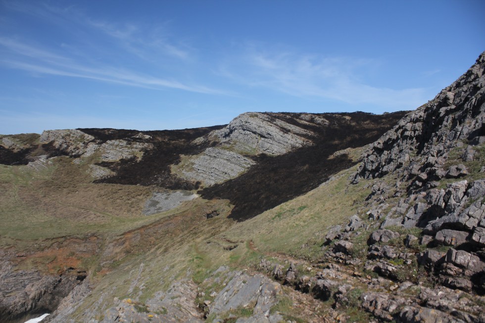
Then the path got rather steep.
Even steeper!
It got so steep that I started to wonder if I had lost the real path and had wandered on to a sheep track as I have done several times. It was so rocky I could not tell whether there were any human footprints or sheep tracks here. I couldn’t see another path so I kept going although it meant that I was scrambling along using my hands as extra support. Not quite on my hands on knees but not far off it.
On the other side of the crest I came across an odd scene. All the gorse had been burnt. You could smell it. I assume that the gorse had been managed. Its seemed too much of an effort for an arsonist to come all the way out here to commit arson. I assume that this is a way of managing the growth of the gorse.
After walking a bit further I realised that off in the distance I could see Worms Head. This was quite exciting. The angle made the long narrow tidal island look like two small islands. It also gave me the idea that Worms Head was not that far away. Now, whilst this was very encouraging and cheered me, by the end the walk I realised that was nonsense. One lesson I learnt from this walk is “just because you can see it, doesn’t mean it’s close”. It has become my mantra. So on I went, buoyed by the mistaken belief that I was half way to Rhossili already.
Towards Worms Head
I think I had not bothered to look at my map in a good while because I was caught by surprise when the path headed up hill and inland. I was the first of many “Where the **** has the path gone” moments. When I walking on my own I chat away to myself (like a nutter). Mostly it’s encouraging stuff like “Come on” and “Let’s do it” when I need to get up a hill but its also less ladylike stuff when I get a bit lost and I can’t find the path. I just hope any near-by sheep are not offended. I also say hello to the sheep and lambs.
I found the path, it had moved inland. It was not at all close to the cliff top so I could no see the sea. Once or twice I tried to sneak a peak at the sea by wandering off the coastal path towards the cliff edge but I decided it was too much effort as I had a long walk to do I didn’t want to waste energy of detours. I also found lots and lots of Gower mud. It was a rather fantastic orangey brown colour.
As I walked along the cliff top I knew I was passing above places with wonderful names like Blackhole Gut, Yellow Top, Foxhole Slade and Paviland Cave. I could not see any of these places from the path. I have always wanted to see Paviland Cave but it is notoriously difficult to get too. It is where the so-called “Red Lady of Paviland” was discovered by the Rev William Buckland in 1823. This was a partial human skeleton dyed in red ochre. The Rev was a man of a times and decided that because there were parts of a necklace made of sea shells and ivory jewelry that this had to be a woman’s skeleton. Today we’d call him “old fashioned”, I think. It turned out that this not a lady at all but a young man and he was buried 33,000 years ago. This was back when woolly rhinoceros and mammoth roamed around what we today call Wales. Incredibly, it is the oldest known ceremonial burial in Western Europe. Sadly, there was no Welsh museums in existence when the “red lady” was discovered so the remains where taken to Oxford, where they still rest despite the fact that we have lots of museums in Wales now.
Eventually, I reached the point where the path crosses with the one from the village of Pitton. I came a across the first people I’d seen in maybe an hour maybe longer. They were having a break. They complained that the path down from Pitton was extremely muddy. I overtook them but I was starting to feel tired. I had been walking for about 2 hours no-stop.
I was just over half way through this walk. So I found a place amongst some rocky outcrops to eat my lunch. I watched some crows flying above the cliffs. For once I ate my banana first. I was really hungry. The cheese and pickle sandwiches and the chocolate biscuits all tasted wonderful. The outcrop called the Knave is nearby and I will continue the second part of my long walk to Rhossili next week.
One result of developing PTSD over 5 years ago is that for a long time I had limited energy. I honestly cannot tell whether my energy levels have returned to “normal” levels yet, or ever will. I find that it takes me a couple of days to recover from social events (and no, it’s not a hang-over as I don’t drink alcohol) or from traveling/visiting family or another town. Maybe, everyone my age is like, I don’t know.
I used to have ambitions or even a sort of “bucket list” of things I wanted to get round to doing, some time. I don’t much care for the term “bucket list”. If you haven’t heard about the term “bucket list”, it is a list of all the goals you want to achieve, dreams you want to fulfill and life experiences you desire to experience before you die. Here was mine.
Learn to surf
Learn to Meditate
Walk the coastline of Gower
Run a marathon
Walk the pilgrimage route to Santiago del Compostela
Visit Japan
I did learn to surf and I was very keen for a while, but I was never terribly good at it. I also once went on a 10-day meditation course. There was no talking for 10 days. Strangely, that was the easy part. I was running 20-25 miles on a weekly basis when my life took a swift left turn and everything ground to a halt in 2012. I am still active but I don’t run very far at all these days. I know I won’t be able to run a marathon unless I gave up everything else and just trained, ate and slept. There would be no energy left over for painting and making a living, so that’s out of the window. I cant afford to travel, not at the moment so it’s going to have to be number 3.Walk the coastline of Gower.
I have a curiosity about exploring the whole coastline of Gower. I know and love certain parts of it very well, such as Three Cliffs Bay. As a painter of the Gower peninsula there are parts that I have visited and painted many times. However, there are also parts I have not visited for years, and a few places I have never visited. I did plan and start to walk the Gower coast in 2016, but it all came to a halt as I tried to cope with the repercussions of being made redundant from my teaching post where I had worked since 1999.
So start again. Here are my rules
Travel in a clockwise direction around the Gower coast
Travel by public transport and by foot.
Walk on sunny days.
Erm, that’s it.
I will document the walk with photos, sketches, and paintings. However, I am nervous about this. The big challenge for me will be in terms of my energy levels. The whole coastline is something like 38 miles long and I know I will have to divide that up into many short walks that will be very tiring for me. I will probably need a week to recover in between walks. I am nervous that I won’t have the determination to finish this, or something will happen to put me off, such as in 2016 when I got part way through in 2016 and gave up. I hate not finishing things.
Coast Watch Station, Rhosilli
It will also be challenging for me mentally. When I was younger, I did many brave things on my own. I traveled around the UK and spoke at Academic conferences, I even traveled to Texas very soon after I passed my driving test and drove a hire car. The PTSD has had the result of reducing my life and what I do, either because I get tired or because I am fearful. PTSD means that my brain goes into anxiety mode very easily. My head will worry about the coming back before I have even left the house. I will convince myself that none of the buses will arrive and I will be stranded in the wilds of the Gower and have to sleep under a bush. Yes, it all sounds stupid when I type it, but that’s the sort of thing that keeps me awake at 3am in the morning.
So I will have to prepare well, take a load of bus timetables and set off early and challenge the fear. A few weeks ago I panicked and jumped into the sea, thinking I was about to get washed off some rocks. Bizarrely, the evidence has given me confidence. The boots and I survived. It was uncomfortable but the boots dried out on my radiator. So I will make a start this week, even if it takes months to complete the challenge.