


My leg and ankle are recovering from my accident this spring and although I can walk a faster than I used to, I still cannot walk long distances which means that a lot of my favourite Gower walks are off limits to me. I find staying indoor too much isn’t good for my mental health (especially during the Pandemic) and it is vital to get out and see different places nearby. Fresh air is good for the soul, the mind and more importantly it blows away the virus!
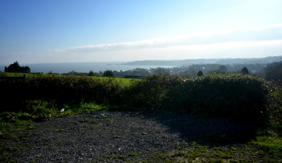
This blog is about a very short road trip around parts of the Penrice estate down to Oxwich Bay we did this week. My husband drove and I took the photographs. Penrice Castle was built by the Mansel Talbots. They were one of the most powerful families in South Wales and certainly one of its biggest resident landowners and MPs for Glamorgan in the Victorian era. The “new” Castle at Penrice was built by Thomas Mansel Talbot in the 1770s, as an alternative residence to the rambling old house at Margam. Thomas, who had travelled to Euope and considered himself a man of great taste had a neo-classical villa built. He also had the land around the house landscaped and a park laid out to improve the romantic scenery that had first attracted him to the place. His son, Christopher Rice Mansel Talbot, who was born at Penrice in 1803, modernised the old Aberavon Port and renamed it (modestly) Port Talbot as an industrial hub for South Wales. The house at Margam was also pulled down and a new mansion was built there between 1827 and 1830 near the ruins of the old abbey.
I will the road trip start with a map. All road trips need a map. There is an excellent map of Gower at Mapsta here. Our trip starts at the top left hand side of the map where a lane turns a sharp left from the A4118 road down a narrow single track lane. A word of warning if you fancy this road trip. This is not a trip for a large vehicle. Most of the lanes are single track and are very narrow. We spent most of it praying that we did not meet any thing coming the other way, and we drive a tiny Kia, as it would have possibly meant a ggod deal of reversing! Thankfully we didn’t.

.


![]()


We saw people. There were not too many but enough to watch. There was even a small wedding party having their photos taken on the beach off in the distance. It was heartening to see people managing to commit to a future together come what may! It must have been next to impossible planning their day as we have had a national lockdown, a local lockdowns and a mini-firebreak and there are rumours of another lockdown after Christmas.


On the way back home, we continue anti-clockwise on our loop back up a steep hill to the main road past Underhill Cottage. It was originally the Head Gamekeeper’s cottage. It has a lovely, sunny position overlooking the beautiful Oxwich Marsh and the sea with Nicholaston Woods behind. These days it is a holiday cottage. It is possibly one of the few sorts of holidays you could be confident of not getting cancelled these days (if you live locally, that is).

![]()
Buy my book “Footnotes: An Artist’s Walk around the Gower Coast” here
Read More
Mansel family and Port Talbot https://www.walesonline.co.uk/news/wales-news/port-talbot-history-origin-name-18664821
Penrice Castle
Penrice – castle
https://www.parksandgardens.org/places/penrice-castle
Holiday Cottages on Penrice Estate. There are 16 holiday cottages on the estate
http://penricecastle.co.uk/gower-self-catering-holiday-cottages-wales/


Once-upon-a-time I worked full time as a teacher in school of just under 2,000 pupils and I would teach approximately 150 pupils in a day. That’s a lot of faces to put names to every day. I was pretty good at learning all those names too. These days, however, I might only speak to a handful of people in a day; my husband, my neighbour and local shopkeepers. So, when presented with an opportunity to met with and chat with to new people I relish it. Clyne Christmas market gave me a lovely opportunity to talk to all sorts of people.
I am pretty new to running a stall, I did it once about 4 years ago. I really enjoyed it back then but teaching commitments meant that I did not have the energy to keep doing it. That has changed now. I have the energy and the time to pursue this and yesterday I had a stall at the first Clyne Farm Christmas market. I realise that I have a lot to learn.
Clyne Farm sits on top of Clyne Common, high up above Swansea. It has sweeping views towards the sea-side village of Mumbles and across the massive Swansea Bay.
Once upon a time it was a riding stables but in recent times it has transformed itself into an top-class accommodation and activity centre.


Yesterday was their first Christmas Market and we were blessed with sparkling crisp sunshine. The photos above were taken in the first half an hour before it got busy. The crowds ebb and flow. After a quite half an hour, it is quickly jammed with families carrying babies wrapped up to the eyes in jump suits and bobble hats. The little girls are drawn to the “Sparkly Bow” stall further down my aisle. The table covered in glittery objects is exactly the right height to catch a 5-year-old’s attention – at eye-level.
This first onslaught is followed by another wave of families with dogs on leads, and in carried in their arms. There are lots of woolly coated “cockerpoos” (Cocker Spaniels Crossed with Poodles) and some sharp-eyed border collies. They take in everything. Later as people leave for lunch in the other hall, it becomes calmer. People are clutching bags with their purchases. I recognise some people who came around earlier return to buy. It’s in the post-lunch calm that I make most of my sales. I chat with many of the people in the hall. My cards of Mumbles Pier starts a number of conversations about a controversial development of the Pier Head area that the local community (Mumbles Action Group) are currently fighting.

I manage a quick break and visit some of the animals on the farm. I’d met Ted the collie and Flo the goat and her surrogate daughters, the sheep Brillo and Lucy, yesterday.


Along a muddy tack there children’s pony rides on offer. I had to make a special journey along a different muddy path to see Peggy the Pig. She is massive. I give her a pat on her broad back and was surprised that her back was covered in bristles, not wiry hair. Her floppy ears cover her eyes, like nature’s sunshades, but it can’t be easy for her to see. I was told by Sarah who works at Clyne, that Peggy is pretty laid back and is a “morning” pig. She is active in the morning and spends her afternoons sleeping. Someone speculates that she’s a Gloucester Old Spot. I assume that they have only one big spot but looking it up later it seems that they were probably right and she’s an “Old Spot”.

The hall is filled with bright sunshine but by the late afternoon, I’m starting to feel the cold. Although there’s carpet in the hall the concrete floor underneath is cold. I run to my car to fetch my woolly hat. As the afternoon wears on I notice that the tip of my nose is numb! After 5 hours in the hall, my feet are starting to feel like blocks of ice. The girl opposite me is wearing thin daps and ends up sitting on her chair with her feet tucked under her. At four o’clock the sun is low in the sky and someone mentions that there’s Christmas Parade in town at 4pm. That seemed to be the signal for the stall-holders to pack up and within minutes the hall is bustling with activity as the stalls are rapidly dismantled. I drive home with the sun setting over Clyne Common.

What I learnt


I am delighted to have sold “Koei 1509”, a painting of a South African cow, to a collector in Oxfordshire, England. The painting was based on a photograph by talented photographer Herman von Bon, who generously allowed me to use his image. Herman photographs the South African landscape along with its people and animals. I particular like his wildlife photography.

I like cows. I love all animals. I come from a family of animal lovers. I get pleasure from just looking at animals. I really enjoy painting them but I find it hard to part with my animal paintings.
Cows are the reason why I stopped eating meat a long time ago. When I was a post-graduate student at Cardiff University in the 1990s I spent a day cycling along the the flat marsh road that lies between Cardiff and Newport. It’s about 10 miles. On my way back, I stopped at a gate for a rest. I group of curious youngsters, Fresians, came up to gate to investigate me. They were cautious but seemed to egg each other on to come closer and stick out their noses to me. They amused me. I thought they were funny and sweet.
I stood for quite a while looking at them. Listening to them breathe. Cows have intelligent eyes. Big brown eyes. They weren’t essentially any different from the many animals my family had kept as pets over the years; cats, dogs and rabbits. Suddenly the thought came to me “I eat you and your friends”. I felt awful. Very guilty.
It felt very unnecessary. I don’t need to eat meat. So I decided to stop. I’d been thinking about for for some time. People sometimes ask why I am a vegetarian and I could mention things such as the cruelty of factory farming, the environmental cost but I have never felt comfortable eating sentient creatures. I always felt a hypocrite for eating Sunday roast, no matter how tasty it was.

Many of my university friends were veggies but I didn’t like many vegetables (potatoes and peas was about it for many years) and I wasn’t sure what I would eat. To be honest, I was lazy. I had to learn to cook vegetarian meals. I started with a lot of pesto and pasta. A friend of mine recommended a Rose Elliot cook book and I painstakingly read the recipes (there were no photos in the book) and I eventually learnt a few recipes off by heart. It was a bit of a slog but I felt much better for it, physically and mentally.
Although I don’t think that I paint cows all that often, they have added up over the years. I love Hereford cattle in particular. I was born in that English county and I love the russet red of their coats. You don’t see that many of them on Gower.

I seems to have painted Frisians the most – probably because I like the contrast of their black and white coats.

Gower Cow
I never paint “generic” cows. These are all real cows. All individuals. I found Gower Cow on the slopes of Cefn Bryn at the Penmaen end. She was chewing the cud with a small group of friends.

The cow at Pwll Du was also with a group of friends, small herd I suppose, who came out of the undergrowth and started grazing on the grass by the stream at Pwll Du.


Writing this post got me thinking about the History of the cow in Art. There’s a lot to it so I have decided to save that for my next post.
To see available animal paintings click here
To see large mounted animal prints click here


I am delighted to have sold this painting, Three Cliff Reflections, to a collector in Scotland. As is so often the case, the collector has a connection to the location in the painting, having visited it and climbed to the top of the peaks quite recently. I hope that the painting brings back happy memories of the summer.
As a painter, I feel that I have succeeded if I my work can provoke an emotional reaction. I would feel that I had gone wrong somewhere if someone said “that’s interesting” or “it’s technically skillful” about one of my paintings. Not that there’s anything thing wrong with being skillful, I just don’t want it to be the first thing they say.
They don’t have to be entirely happy emotions, either. I once had a friend who said a painting of mine, “Park Bench in the Snow” made her want to cry.

I am not sure why she wanted to cry, I think she said something about it reminded her of the film “It’s a Wonderful Life”. That film always makes me cry too. Mind you, I was particularly fond of this painting and was pretty sad when I had to part with it. I didn’t cry though. I do have favourites, and this was one.
Quite a few of my people portraits have a bitter-sweet quality to them as I am drawn to the fragility or vulnerability of the sort of people who are frequently overlooked by our instagram obsessed society.

Or amusing quality, I hope. I like observing little moments that are easily missed. Like these two children at the Uplands markets examining an old manual typewriter.

I also like watching for moments between dogs and their owners, in particular.

Back to Three Cliffs Bay. This painting “Human Concern” (below) was based on a scene I observed at Pobbles Bay, last summer. Pobbles Bay is right next the Three Cliffs Bay. The little Jack Russsell stood and watched his humans off in the sea, with such intensity. It amused me. I also found it very touching.


Part 2: Llanridian to Crofty
This is the last stretch of my walk around the Gower coastal path. I started this particular walk at Llanmadoc, which is three miles along a generally flat, but not always obvious, grassy and often muddy path.
As I approach Llanrhidian, the atmosphere changes from rural scruffiness to urban tidiness; where the grass is kept short by electric mowers rather than by sheep. I pass along a path with a wooden fence along the one side. This seemed a bit of a shock after all the open spaces.


Llanridian itself is picturesque. It feels very much like a village that has been here for hundreds of years.


There is a unique church dedicated to Saints Illtyd and Rhydian in the village. The village that grew up around the 6th century church was founded by St. Rhidian, hence it’s name – “Llan” (meaning religious enclosure) “Rhydian” (the founder’s name). Rhydian dedicated the church to St Illtyd, another Celtic saint who was believed to have lived here. You may remember St Illtyd, he was the Celtic founder of the sea-side church at Oxwich and has many churches dedicated to him across Gower and South Wales.

The church that exists in the village today was built in 14th century. It has a holy well and something known locally as a “leper stone”, as well as a 11th century wheeled cross shaft near it.

The so-called leper stone is a probably the remains of a door lintel, or maybe even or tombstone lid and dates from the 9th century. I probably did not have any connection with lepers was, other than in the imaginations of the Victorian who discovered it near the west tower doorway it in 1865 and subsequently had it moved to the church porch.

According to tradition, when St. Illtyd lived on this spot as hermit, the sea often flooded the site, destroying the saint’s cell and chapel. Several times he built an embankment of mud and stones to protect himself, but in vain. He asked an angel to help him and the sea obeyed the saint, subsiding. He then struck his crozier on the dry shore and a holy well gushed forth, instantaneously. This well still flows today and is said to have curative properties. It is located in a private garden near the Church. It also known as the “milk well” or “butter well” , by locals, as in 1185 milk and butterfat was seen flowing in it instead of water, according to the Annals of Margam. This miraculous event was said to have lasted for at least three hours.


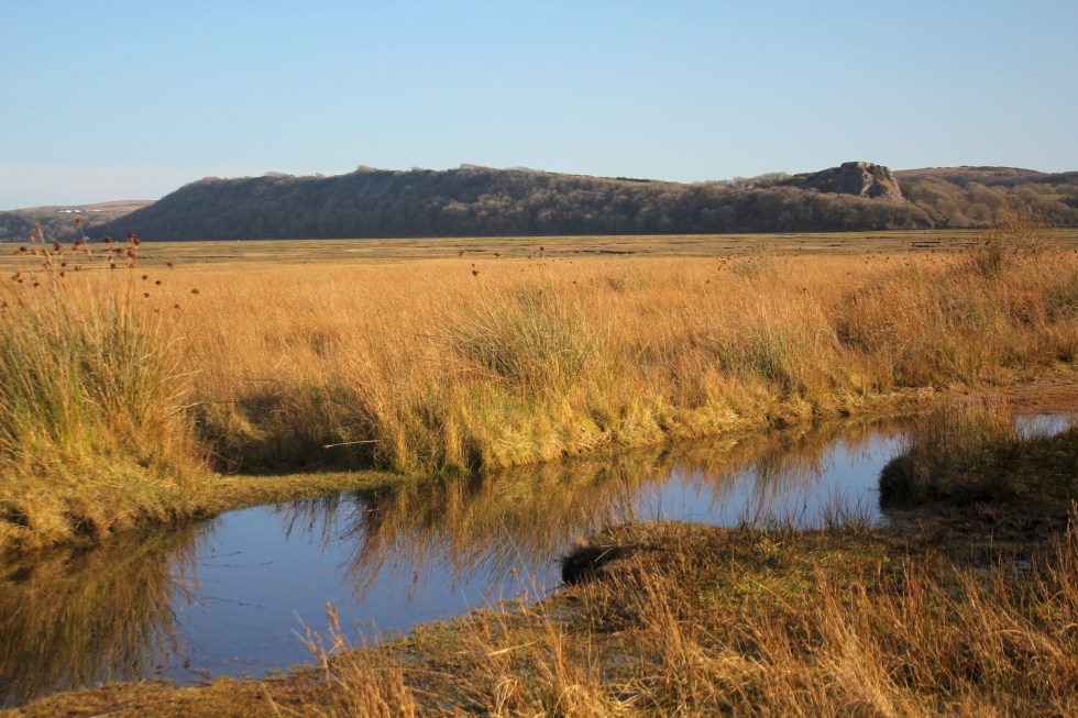
Here I joined the coastal road. The atmosphere changes back to the marsh wildness with the mild peril of possible flooding.

It the only true coastal road on Gower. It skirts along the side of the wide marsh from Llanridian to Crofty.


I could see Crofty off in the distance, but I wasn’t going to be fooled into thinking it was close because I could see it. I can see Port Talbot from Swansea Beach, it’s still 13 miles away an in no sense “close”. Same goes for Crofty. Turns out its three miles from Llanridian, which was possibly further than I realised when I decided to trudge it’s length. It figured, its flat. It’ll be easy!

Well it was flat but it was also a very long road. It was a very empty road. I passed only three cars/vans and one cyclist in the two hours I was walking on it. The cyclist nearly ran into me when I walked into his path.

I was my fault as I didn’t look over my shoulder when I heard a noise behind me, but I was very tired at this point.

I stopped several times to take photos and enjoyed watching the light change as the clouds moved above my head. It may seem to strange to say, that this was probably my favourite part of all my Gower walks. Strange, it was very beautiful but I decided that I wasn’t going to paint this landscape. It’s too flat for my painting tastes. Maybe that’s why I enjoyed it all the more. It’s even hard to capture its essence in a photograph.

I haven’t attempted to paint it but I loved the sense of wilderness here that it’s present anywhere else along the Gower coastline.

At one point there must have been a lull in the cold wind and a silence fell and then I heard a rustling in the trees and bushes behind me and then a moment later, I felt its force. It was rather eerie to feel the force of nature.

Off in the distance was an aeroplane circling round and round the estuary off over Burry Port where Amelia Earhart landed all those years ago. Amelia was the first woman to fly (or be flown) across the Atlantic Ocean in 1928, when she flew across the Atlantic, this time as the pilot and on her own, four years later she landed in Northern Ireland.


I finally reached the village of Crofty.

It had a distinctly urban feel to it, not like Llanrhidian. By now had drunk both of my 500l bottles of water. I had very sore and stiff legs but I forced myself the trudge with purpose because I knew that I had about 20 minutes to make it to “New Road”, the main road, and catch the bus back home.


As I cut through the streets of Crofty, the roads all seemed unreasonably long but I eventually found the main road and I started walking in the direction of Llanridian. A bus shelter stop appeared.

It seemed like a miracle to my tired legs. A bus appeared – a number 116 it its distination read “Llanridian” and not Swansea. I was so excited to see a bus with the number I was looking for I hailed it. The rotund bus driver looked at me slowly. No, this wasn’t the bus to Swansea. The stop for that was on the other side of the road. I looked across the road. So he pulled off and I crossed to the other side of the road, although there was no bus shelter or bus sign there. So I waited and waited. After about ten minutes, a school bus pulled up and some street-wise-looking teenagers got off. None of them looked like they were rushing home to do their homework.
Eventually, after I started wondering if Crofty had a taxi service or I’d have to stumble another two miles up the road to Penclawdd, a number 116 bus appeared. It said Swansea on the front. The bus indicated that it was stopping before I put out my hand to hail it. That was handy, I thought. I stepped onto the bus to show the driver my return ticket and as I glanced into his sour face, I realised that he was the same bus driver I spoke to twenty minutes earlier. Not a flicker of recognition passed over his face. I walked to the my seat, glad to sit down after 4 hours walking, chuckling to myself.
I had covered 6 miles and my feet were throbbing. It was a funny end to the walk. I had not seen the sea or river all day but I had smelt the salt and felt the wind. I had hardly seen a soul. It certainly the wildest and flattest part of the coastal path. I was glad it was over and my challenge was finally complete, Well, almost.
Post Script
This isn’t quite my last Gower coastal walk. I haven’t walked out along the causeway to Worms Head. However, you cannot climb to the top of the outer headland between the 1st March and the 31st of August – as it is closed in order to protect the many breeding sea birds, so I am waiting until September to do this final walk.
Below is a short video clip of the marshes near Llanmadoc. I’m afraid its rather poor, turn off the sound, but it’ll give you a good sense of of how vast and flat the marshes are.

Part 1: Llanmadoc to Llanridian
I was feeling very nervous about this walk as I would have to change buses in the middle of nowhere. I very nearly chickened and got in my car after a fellow blogger commented that I “should not bother with rural buses but drive. However, it was a long walk, just over six miles, and I did not want to break it up into two or three circular walks. I wanted to walk the length of the north Gower coast in one go, if I could. So I got up and packed sandwiches, lots of biscuits, a banana in its strange yellow banana “gimp” case and two bottles of water. I had decided that thirst was the worst torment on my last two solo trips and I was going to be better prepared this time.

I had caught the same bus to Port Eynon (the number 119 to Rhossili, if you interested) and had changed at Scurlage but this time I had to change at a location called Llanridian Turn. I have studied the map and I think I know where it is. I don’t remember passing it from the previous bus journey and it doesn’t really seem to be “on the way” to Rhossili. So I check with the bus driver as I buy my ticket.

The bus arrives at Llanridian Turn and it pulls in behind another bus, a number 116, but its not the one I want. So I ask the driver about the 115 to Llanmadoc and he says that he’s driving it and walk towards a small bus that has just arrived and he swaps buses with the new driver. He’s a friendly chap, with a sparkly diamante earring in one of his ears. So we set off. I am the only passenger.

I end up standing at the front of the bus (holding on to the special rail) chatting to the driver for most of the journey. “You couldn’t ask for better weather” he says. He’s right. It’s a sparkling bright spring morning. It’s cold though. Only 7 degrees Centigrade (that’s 44 in Fahrenheit). He fishes out a timetable for me from his rucksack. It’s a timetable that covers all Gower buses. I have not seen this before, it certainly wasn’t to be found in the bus station anyway. “Where do you want to get off?” I have never had a bus driver ask where I want to stop before. This must be one the joys of rural bus services. I eventually get off by Llanmadoc Post Office. I wave at the bus driver as he drives away as if we are old friends.


I find a path, not an official coastal one, but it is sign posted for Whiteford Burrows, which seems the right direction, so I take it. It’s more of a farmers’ track than a path. I walk down a long muddy track, pass cattle, sheep and an old tractor and eventually reach the same point as we did on our detour from Cwm Ivy (to avoid the breached sea wall). I find it more by luck than any thing. It is very muddy.


This is Landimore Marsh. It’s a saltmarsh, an area of coastal grassland that is regularly flooded by seawater. Springs, small rivers called “pills”, flow out into the estuary, in meandering lines that make maze-patterns in the marsh. The main pills crisscrossing the area are Burry Pill and Great Pill.

For hundreds of years, the people who lived along its edge have used the marshlands for grazing their animals. They still do today. The lambs that are raised on the salt marshes are reputed to have a distinctive and special flavour, but I cannot speak from experience as I am a vegetarian. Although the cows and ponies know to move off the marsh with the advancing tides, especially the spring tide that can move with great speed, the sheep for some reason don’t. The local farmers have to bring them in. Although sheep can swim, as all animals can, for a short period of time, if they get cut off by the tide they will drown.


The walk along the marsh path is very muddy indeed. I have visions of me sliding and twisting my ankle or falling flat on my face, but I manage to survive without incident. I take the low tide route, but I spent much of my times sliding around wondering if the high tide route would have been less muddy.
To my right is North Hill Tor, or Nortle Tor, on which are the remains of a partial fortifications, probably dating back to the Iron Age period (c. 800 BC – AD 43). According the the famous Swansea-born historian, Wynford Vaughan Thomas, Nortle Tor was quarried in previous centuries. During the Napoleonic Wars, one of its extensive caves provided useful hiding place for local young men when the press gang was spotted coming across the estuary from Llanelli.


There is a wonderful presence about the marsh. It stretches away as flat as a proverbial pancake. No sea, or River Loughor in sight. The marsh is indented by patterns of muddy pools, creeks and channels. It is very peaceful and I get drawn into the atmosphere of the marsh. The grass has a curious white-ish tinge to it which I assume is from the salt. I see a lot of sheep’s footprints but no sheep, although I can see a few ponies far away on the marsh. It turns out that the sheep are in the farmers’ fields with their lambs.


The path eventually passes a couple of houses and leaves the marsh. I see my first fellow walkers of the day. I only see one other couple on the path today. I see, however, vast numbers of sheep and lambs, marsh ponies, robins, sparrows, a red kite and a large Great White Egret flying over the marsh.


The path reaches Bovehill, where it turns further inland and passes the remains of another fortification, Bovehill Castle, a fortified mansion with walls a metre thick. It was once the seat of the 14th century crusader knight, Sir Hugh Jonys and later Sir Rhys ap Thomas, a support of Henry Tudor (the father of Henry VIII of six wives fame).


Ivy Cottage Landimore
The “coastal” path then turns off the road onto Bovehill Farm. I can’t see the sea and now I can’t really see the marsh, either. I don’t see the marsh again for a long time, perhaps for about as much as an hour as the path trails inland. In fact, it turns out its about 2 and a half miles to Llanridian. The path instead, runs through the farmland, parallel to the marsh.


This get a bit confusing. I often enter a field and have little idea of where the path goes. So I set off at a 60 degree angle only to adjust my course when I eventually spot the stile in the opposite corner of the field.

There have not been enough walkers recently to make tracks for me to follow across the fields.

I see swallows (the first I have seen this year) over the fields by Landimore. Weobley Castle, another fortified manor house, is a dark presence looming on the cliff above me. From the time of the Norman conquest of Gower to the 15th century, Weobley belonged to the de la Bere family.

Just below Weobley Castle there is a road that leads out into the marsh.

Where does it go? It doesn’t seem to go anywhere, as such.

At the end of the track, there is a odd wooden structure out in the estuary. I can see it with my naked eye but my camera is struggling to get a good picture. I think its made of wood. I can’t tell. You can see it from miles around.


According to historian Wynford Vaughan Thomas, the American army used the marshes as a firing range during the Second World “War. It turns out that it was the US army that built the causeway out into the marshes. The strange building, is not wooden but made of concrete and brick. It was a look-out built by the Americans. I have to search online for close up photographs.


Photo credit: mylifeoutside.co.uk
There is a very dark tale about the Burry Estuary during the Second World War that Wynford was probably not aware of, as it was kept secret until 1999. There had been rumours about the secret testing of chemical and biological weapons in the estuary during World War II for many years. This story is to do with the British government and experiments in biological warfare, not the American Army. The wartime government had asked Porton Down, its chemical warfare research installation, to conduct trials of an anthrax bomb. Anthrax, is a lethal bacteria, which was seen as having “enormous potential” for biological warfare. I would like to point out that biological warfare was, and still is, banned under a 1925 Geneva protocol. This is why countries will make a big fuss about its use on civilians in Syria or even Salisbury, England.

In 1941 there had been a series of tests of anthrax bombs on the uninhabited Gruinard Island, off the west coast of Scotland. These tests had produced contradictory results, primarily due to the soft, boggy ground at Gruinard, so it was decided at short notice to carry out a single replacement test on the firm sand of the Burry Inlet.
On a Wednesday afternoon, in late October 1942, the scientists carried out an experiment over the north Gower salt marshes, dropping an anthrax bomb from a Blenheim aircraft. Two lines of 30 sheep were placed downwind of the aiming mark, spread at 10 yard intervals. When the bomb fell it made a crater of about three feet in width and two feet deep. Three days after the trial, two of the sheep died of anthrax septicaemia, and three others were ill for a day or so before recovering entirely. Apparently, the scientists proclaimed the test result ‘very satisfactory’, especially as this was the first time such a bomb had been dropped from a plane flying at operational level.

According to the report, the site was ‘effectively decontaminated’ by the incoming tide a few hours after the test took place. The carcases of the dead sheep were ‘buried deeply at the seaward edge of the marshland area’. The remaining sheep were observed for seven days after the test, the survivors then being slaughtered and buried.
This all seems a bit of a casual clean up and in marked contrast to the situation at Gruinard island, which had served as the previous test site for anthrax. In that case the entire island was set ablaze and subsequently closed to public access for nearly 50 years. Even today people and animals alike avoid the island, despite efforts to decontaminate the island in the 1980s. All I can assume is that larger quantities of anthrax was used in Scotland.
Update: There’s no need to worry about the dangers of anthrax as it was confirmed in 1987 that “investigations …[after the] trial revealed no evidence of any residual contamination”.

When the path finally reaches Llanrhidian, it seems like quite a shock after all the open space of the marsh and the fields. I think about walking up to the main road where I could catch a bus home but instead I press on .
My next post will be my final stage of the coastal path, from Llanrhidian along the coastal road to the village of Crofty.


I have a confession to make. This walk was done out of sequence. It was done on March 28th, on the day the clocks went forward. That seems a long time ago. It was a beautiful day but very cold. Back in March when I had only got as far as Pennard and Three Cliffs, I sort of panicked. This was because I could not make head nor tail of the bus timetables and doubted that I could make it around the coastal path by public transport. So my husband, Seamas, suggested that we drive to the most out of the way places in Gower and do circular walks and then I would fill the rest in with public transport. Another blogger has since directed to the invaluable traveline.info which helped me made sense of the bus connections, when the online bus timetables seemed incomprehensible to me.
So we decided to go to Whiteford Point. It is a mini-peninsula off the northern corner of Gower peninsula. This is seen by many as the wildest and most remote part of Gower. We drove along the narrow lanes to the northern tip of Gower, to the village of Llanmadoc. Llanmadoc Hill is quite imposing as you approach it from the South East. I generally think of Gower as having two big hills (Cefn Bryn and Rhossili Downs) but Llanmadoc Hill at 152m is pretty high too. You get a sense of how it dominates this corner of the peninsula from Cedric Morris’s painting of it in 1928.

If you drive through the ajoining villages of Cheriton and Llanmadoc, you will come to Cwm Ivy Court Farm.

On the opposite side of the leafy lane is an open gate to a field, which acts as a temporary but well-used car park. When we arrive after lunch, it is pretty full. There is an honesty box built into the wall for walkers to put their car park fee of £1. Considering the National Trust charge up to £5 at Worms Head, it seem like a bargain.


We then walk down the lane past a small number of houses, the last one has a ice-cream tub of drinking water for passing thirsty dogs. Once you pass through the five-bar gate you are on National Trust land.


In 1953 it was designated a Site of Special Scientific Interest as it is an internationally important feeding ground for wading birds and wildfowl. Not long after in 1965, Whiteford Point came up for sale by auction and there was great worry that it might fall into the “wrong hands”. Fortunately, the National Trust was able to buy it. This was the first property to be acquired as a result of something called “Enterprise Neptune”, which was the National Trust’s campaign to protect Britain’s coastal heritage. So this area is a now a nature reserve owned by the National Trust.

If you follow the lane down hill there there is a choice.


Straight ahead is are the marshes and sands dune and eventually open beach that joins with the wide expanse of Broughton Bay, to the west. If you take a turn right through another wood gate you are then in Whiteford Burrows.

Whiteford (pronounced Whit-ford) is apparently derived from the Danish ‘Hvit-Fford’, meaning white ford. The Vikings left their mark on the outward-facing west coast of Gower, in their placenames at least. Look at left side of the map above. Worms Head, Burry Holmes and Whiteford are all derived from Scandinavian words. Perhaps, the Viking who traded and marauded up and down the Bristol Channel as late as the 11th Century, only ever gave names to the landmarks they could see from the water, but they certainly stopped by at Swansea, whose name is also Scandinavian in origin. It means “Swein’s Eye” or Island. There used to be an island at the heart of Swansea until the Victorian diverted the river. The Welsh call it “Abertawe” which means the mouth of the River Tawe.


Once into the the nature reserve you pass the very cute Burrows cottage, which used to be a forester’s cottage (you can rent it) and further along the path Cwm Ivy Bunk House (which you can also rent by the night). There are no other houses on Whiteford Point. It is a very lonely place from a human point of view. It is however, full of undisturbed wildlife.

Either side of the path are many grand pine trees, smothered with massive pine cones. They are Scots and Corsican pines. I think gives the place a Mediterranean air. They were planted from the 1930s onwards. There are hundreds them, thousands. I have read somewhere that there were 20,000 in the 1970s. They help certainly help stabilise the dunes and stop the sand blowing away. You can see these trees from miles around.

I get excited when I see what I think are public toilets in a very tasteful wooden chalet on the path ahead. I am always looking for “proper” places to relieve myself instead of the inevitable bushes.

Not toilets!
Ah, what a fool, I am. As I get closer I realise my mistake. Its not a nice artisan toilet block. It’s a bird hide for watching wildlife on the salt marsh to the right. The door is open and we can see its empty. So we go in and peer across the flat marsh. We don’t have the patience to wait.


[wpecpp name=”Woods at Whiteford Sands Large Mounted Print” price=”45″ align=”left”]
Once we have passed the bunk houses we follow a sort of path through the pine woods, climb a stile over a wire fence and we are on the burrows. Whiteford Burrows, or sand dunes, cover an area of three square miles. It’s bigger than it sounds. There is a vast expanse of beach on the other side of the dunes, leading out along the edge of the Loughor Estuary.


It was a long walk along the beach – it a very empty beach. Two miles of it to Whiteford Point. People are small dots off in the distance.

The landscape here is reduced to stripes of colour: Sky-sea-beach-dunes. The tide is out and the sea is very distant.

I am slightly unnerved by the signs saying informing me that Burry estuary was used as a shelling range by the British army during World War Two and the unexploded bombs are still likely to turn up in the sand dunes. Yikes! I take this seriously, I remember a World War Two bomb that was recently found in the near by Loughor River although I can’t find the story online. In 2015 a family found what they thought was a “buoy” covered in barnacles on the northern side of the estuary, at Burry Port. The kids spent quite a bit of time jumping on the strange object and had their picture taken next to it. You have probably guessed it by now. It wasn’t a buoy it was an old Second World War bomb. The beach was cleared and the “buoy” was blown up.

Shells still turn up at Whiteford Point too. In September 2014, for example, some sixty shells were exposed at Whiteford Point, and bomb disposal teams were summoned to deal with them. The firing range was also used on a regular basis for the firing of chemical shells during the Second World War, including ones containing mustard gas. Earlier this year there were reports of the Ministry of Defense blowing “something” up earlier this year in the Loughor Estuary so I don’t fancy taking my chances and stick to the beaches. I expect most people do the same and the dunes are left undisturbed.

At Whiteford Point there is a curious cast-iron light house. It is the only wave-swept cast-iron tower of this size in Britain.

It reminds me of a giant bird cage. The local seabirds, gulls and cormorants use it as a convenient perch. It is not close to the beach but it can be reached at low tide, although its a long rocky walk over the seaweed-covered rocks.

[wpecpp name=”Wave-Swept Iron Tower Large Mounted Print ” price=”45″ align=”left”]
It reminds me that much of the Gower coast was always hazardous to shipping. This area in particular was very treacherous and a large number of ships were wrecked at both nearby Broughton Bay (where ships used to be able to anchor in the bay until it was silted up in mid-nineteenth century) and here along Whiteford Sands.
Tragically, the lighthouse failed to prevent a one of the biggest shipping disasters in the area, which took place in January 22nd 1868. On this calm winter night 16 ships out of a fleet of 19 sailing out of Llanelli, sunk in a single night and possibly up to 30 or more lives were lost. These ships had been towed out of Llanelli by steam tugs. They had been cast off and rounded Whiteford point, aiming to clear Burry Holmes with the ebb tide. This was in the age of sail and the ship needed a breeze to power them on their way.
Unfortunately, the wind died and a heavy swell tore the ships from their anchors and drove many of the ships onto the rocks at Broughton Bay, or smashed them against each other. As it was such a quiet night, no one on shore had any idea of the disaster that was happening in the estuary. A large buoy and chain and the remains of a wooden hull near Whiteford Point are all that is left of these ships.

Although the beach seems utterly deserted the air is filled with the high pitched piping sounds of little wading birds.

They are too far off to identify with any certainly, but I think they might be oyster catchers. We are feeling tired after our long walk along the beach. We sit on the edge of the dunes for a rest and chocolate biscuits, listening to the euphoric trilling of skylark song.

Around the tip of Whiteford Point the path reappears and winds its way along the edge of the pine woods. The path is very water logged and at many points it resembles a series of small still lakes rather than a path. So we hop from muddy patch to muddy patch.
Here there is lots of bird song – blackbirds, ravens, rooks and we saw linnets, larks and tiny robins. On this side of Whiteford Point, it is very flat marshland. The sea is but a distant memory. This is clearly a river estuary and the river is far off beyond clumps of pine trees. The marshes are covered in lush grass and edged by yellow reeds. There are shaggy marsh ponies, who seem very small in comparison to their cousins who graze on Cefyn Bryn and Fairwood Commons.


As we get closer to Cwm Ivy, our starting point, we can see the village Llanmadoc spread up the hillside. We pass the late Medieval sea wall. There has been a sea wall at Cwm Ivy since the late 17th century when it was used to reclaim the marshland from the sea. The coastal path used to follow the wall round to Llanmadoc. Not any more, not since 2014 when the wall was breached by storms. The Welsh Government Shoreline Management policy stopped the National Trust from repairing the wall and breech. This ‘No active intervention’ policy of letting nature take its course was a controversial decision at the time. So this fresh water marsh has now returned to being a salt marsh. The breach is too big to jump over, there’s no bridge so you have to take a diversion at Cwm Ivy to reach the rest of old coastal path (which we did on another day).


The walk took us three hours, but as much of it was on sand so it was pretty tiring. We only took 4 biscuits with us, thinking that our lunch would see us through. I decided that I should have taken a couple of bananas and sandwiches too as you always need more food than you think you will need. If you don’t eat them I know of two helpers who will happily finish them off for me.

Next week: My final very long walk around the Gower Coastal Path.
[maxbutton id=”5″ ]

When I get hold of an idea I can get quite obsessive about it. Lately, it’s been early morning light. I think it sprang from a post I wrote about transposing some of the techniques I used for my “Urban Minimal” project to what I only half-jokingly called “Rural Minimal”. I think that my rural Gower houses did fulfil the spirit of “Rural Minimal” but it got me think about shadows. Now, shadows were my first love. They still are. It’s hard to find any painting of mine without blue/mauve/purple/brown shadows. I go through tubes of Lukas 1862 Mauve at a steady rate. Many of my Gower woodland paintings used early morning winter light.

[wpecpp name=”Enchanted Wood Large Print ” price=”45″ align=”left”]
And why do I love shadows so much? It’s because they act as a foil to the light. The orange next to the dark mauve positively leaps off the canvas. Perhaps, its a cheap way of thrilling the viewer? I am always very impressed by artists who capture a gloomy or overcast landscape. Plein Air painters prefer overcast conditions because they are more constant and American artist, Jeremy Sams, demonstrates this really well in his painting. He says “The good thing about painting on an overcast day is that you don’t have to chase shadows. The light remains very constant and my acrylic paints stay wet for a good long while.”

However, I love shadows. They make a composition interesting and dynamic. So, anyway, the post about Rural Minimal got me thinking about shadows in rural settings. I realised that because I have been focusing on my Gower Walks and working to bus timetables that I was mostly walking in the late morning and finishing up in the early afternoon. I was becoming increasing frustrated that my lovely walks weren’t inspiring the sort of paintings I like to make. The light wasn’t right. Midday light, especially in the summer, has a tendency to bleach out the details. This is what shadows “do”, they show us the details of the landscape.

I have always been a morning person. Each morning is like a fresh start to me. What ever happened yesterday, last night is gone.To be honest, I think that have always done my best work by 11 am. When I was writing my PhD thesis, many years ago, I’d do my best writing between at 8 and 11 am. To be honest, most of the work I did after 11 am was fact checking (this was in the days before the interest when you had to look things up in books) and faffing, but I’d dutifully stay at my desk til 5 pm.

So I decided that I need to seek out early morning light on Gower. This long spell of hot weather meant that morning skies were often (but not always) clear. That meant getting up early. I have been dragging myself out of bed just after sunrise. It’s summer and the sun rises just after 5 am in here Wales. It is painful getting up that early but once I have had a cup of coffee I can face the outside world, just about.
The first time I drove down to Three Cliffs Bay, 6 miles away, I was so tired that I actually forgot my camera! I felt so stupid but I got back in my car and drove back home to fetch the darn thing, delaying my “start” by 30 minutes.

Compare the light and shadows to yesterday morning (when I remembered my camera) and actually got there for about 6.30am.

It’s different. Not necessarily better, just different. Do you know what, it doesn’t matter. I like both conditions. The changing tides always also variety and interest. Summer Morning light has a beautiful rich quality to it and I like seeing how it changes, the shadows shorten, darken, light break over the cliffs, as the morning progresses. I have sat down on the cliff tops and watch the light change.

I like seeing nature first thing. I like seeing the dew. In this very dry summer it’s a godsend. The grass on rolling fairways of Pennard golf course has turned the colour of straw except for the patches where the dew collects in the morning. There it’s a fresh green. Walking down towards the sea, along the sandy path by the golf course, I often see the white tails of wild rabbits dashing into the undergrowth. Their numbers in the UK have fallen in recent decades but thankfully, there seem to be plenty on Gower.

Free-range cows roam the cliffs of Pennard and South Gate as well as the valley next to Three Cliffs Bay. They are usually busily eating the grass they can find down in the marshy valley or in the shadows of the thorny gorse bushes, or even in the Golf Club car park before the golfers arrive!


Cows chewing the cud (mid morning) and cows at work, eating grass (early morning).
I delight in the long shadows and the reflections at low tide. How the reflected light is more golden than the light on the rocky cliffs.


At high tide the colours all change again.


I have got up early and visited Rhossili, Penmaen and Three Cliffs Bay six times in the past fortnight. This includes the morning I thought the light cloud would clear but instead it thickened. A passing Jack Russell was photographed, as well as the rabbit above. So, I sat down and sketched.


I will keep going until this weather goes off, while may well be very soon. I will be working from this research for quite a while after it has clouded over again.
A while back, last June in fact, I read an excellent blog post by American artist Luann Udell entitled “How Long Did It Take You To Make That?” in which she discusses all time-consuming processes and skill that go into creating her pieces. It occurred to me that while the actual time it takes to paint my work may take anything from one to three days, depending on the size of the canvas, the actual thinking, planning, gestation, waiting for the weather and preparation takes a lot longer. I should also include in that waiting for the seasons to change. Just yesterday I was remarking to my husband that the heather was starting to flower and so another visit to Rhossili Downs would be in order soon. Nothing stays the same in nature, or in life! My job is to observe and attempt to capture some of those fleeting changes.
Enquiries about Commission Always Welcome – Find out more here
