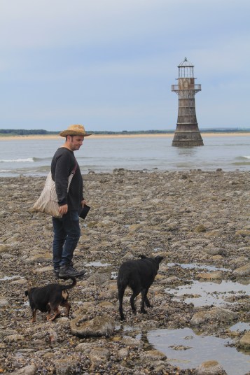
It was a long walk to the lighthouse at Whiteford Point on the northern tip of the Gower Peninsula. The last time I walked here, I just looked at the lighthouse from the beach. This time I wanted to get up close. We had left it late and the tide had already turned when we got here. The last stretch to the lighthouse is across lots of slippery, small rocks were surprisingly difficult to walk across. It took a good 20 minutes to make our way across them.
I was accompanied by Seamas, myy husband, and our loyal dogs, Biddy and Mitzy, who were not keen on the rocks but will follow Seamas anywhere.
Seamas (in hat) and dogs at Whiteford Lighthouse
The iron victorian lighthouse had cormorants perched on it when I got there (ahead of the others) but a motor boat came past and they all flew off!
Birds flying away from Whiteford Lighthouse
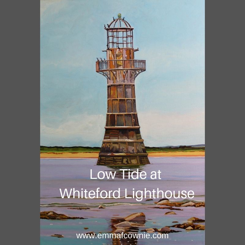
Here’s my painting. I love the colour of the rusted iron of the massive thing and the sea-life that clings to the lower half. It was a hazy day so the sky is bluish and the sea has a slight mauve tinge to it. The waves are gentle but advancing.
This is the first woodland painting I have done for quite a while. This is a section of pine woods called Canisland Woods, near Ilston and Parkmill, Gower. The slender light refers to the beam of morning sunshine light breaking over the lip of the valley. The pine needles on the ground are soft and deaden any sound. It is a very peaceful section of woodlands.
As an artist, I am always looking how to simplify shapes/colours so that there is an semi-abstract element to them but never losing touch with realism. This is particularly true of my woodland paintings. Although I am working from photographs, I am not copying them but rather deconstructing (in my mind) and then slow reconstructing them (on the canvas). They are like a giant jigsaw puzzle.
It’s painful and I find the mid stage of these paintings a bit distressing until I have faith that it will come together and make a pleasing painting. Some paintings are easy and there is little struggle. Sometimes, the struggle will last a couple of days. I have to ignore the voice in my head that says, “it’s rubbish” and “you are wasting your time”. Thankfully, the negative voice is usually proved wrong.
With all of my paintings, I like to pursue a theme over several paintings so that I get into a “groove”. I feel that I am now in the groove with “Slender Light”.
See “Slender Light” and other available landscape paintings here
I have a confession to make. This walk was done out of sequence. It was done on March 28th, on the day the clocks went forward. That seems a long time ago. It was a beautiful day but very cold. Back in March when I had only got as far as Pennard and Three Cliffs, I sort of panicked. This was because I could not make head nor tail of the bus timetables and doubted that I could make it around the coastal path by public transport. So my husband, Seamas, suggested that we drive to the most out of the way places in Gower and do circular walks and then I would fill the rest in with public transport. Another blogger has since directed to the invaluable traveline.info which helped me made sense of the bus connections, when the online bus timetables seemed incomprehensible to me.
So we decided to go to Whiteford Point. It is a mini-peninsula off the northern corner of Gower peninsula. This is seen by many as the wildest and most remote part of Gower. We drove along the narrow lanes to the northern tip of Gower, to the village of Llanmadoc. Llanmadoc Hill is quite imposing as you approach it from the South East. I generally think of Gower as having two big hills (Cefn Bryn and Rhossili Downs) but Llanmadoc Hill at 152m is pretty high too. You get a sense of how it dominates this corner of the peninsula from Cedric Morris’s painting of it in 1928.
If you drive through the ajoining villages of Cheriton and Llanmadoc, you will come to Cwm Ivy Court Farm.
Far Hill Above Cheriton, 2016 (SOLD)
On the opposite side of the leafy lane is an open gate to a field, which acts as a temporary but well-used car park. When we arrive after lunch, it is pretty full. There is an honesty box built into the wall for walkers to put their car park fee of £1. Considering the National Trust charge up to £5 at Worms Head, it seem like a bargain.
We then walk down the lane past a small number of houses, the last one has a ice-cream tub of drinking water for passing thirsty dogs. Once you pass through the five-bar gate you are on National Trust land.
In 1953 it was designated a Site of Special Scientific Interest as it is an internationally important feeding ground for wading birds and wildfowl. Not long after in 1965, Whiteford Point came up for sale by auction and there was great worry that it might fall into the “wrong hands”. Fortunately, the National Trust was able to buy it. This was the first property to be acquired as a result of something called “Enterprise Neptune”, which was the National Trust’s campaign to protect Britain’s coastal heritage. So this area is a now a nature reserve owned by the National Trust.
Whiteford Point
If you follow the lane down hill there there is a choice.
Straight ahead is are the marshes and sands dune and eventually open beach that joins with the wide expanse of Broughton Bay, to the west. If you take a turn right through another wood gate you are then in Whiteford Burrows.
Pine Trees
Whiteford (pronounced Whit-ford) is apparently derived from the Danish ‘Hvit-Fford’, meaning white ford. The Vikings left their mark on the outward-facing west coast of Gower, in their placenames at least. Look at left side of the map above. Worms Head, Burry Holmes and Whiteford are all derived from Scandinavian words. Perhaps, the Viking who traded and marauded up and down the Bristol Channel as late as the 11th Century, only ever gave names to the landmarks they could see from the water, but they certainly stopped by at Swansea, whose name is also Scandinavian in origin. It means “Swein’s Eye” or Island. There used to be an island at the heart of Swansea until the Victorian diverted the river. The Welsh call it “Abertawe” which means the mouth of the River Tawe.
Once into the the nature reserve you pass the very cute Burrows cottage, which used to be a forester’s cottage (you can rent it) and further along the path Cwm Ivy Bunk House (which you can also rent by the night). There are no other houses on Whiteford Point. It is a very lonely place from a human point of view. It is however, full of undisturbed wildlife.
Either side of the path are many grand pine trees, smothered with massive pine cones. They are Scots and Corsican pines. I think gives the place a Mediterranean air. They were planted from the 1930s onwards. There are hundreds them, thousands. I have read somewhere that there were 20,000 in the 1970s. They help certainly help stabilise the dunes and stop the sand blowing away. You can see these trees from miles around.
The pine trees as Seen from Hills Tor
I get excited when I see what I think are public toilets in a very tasteful wooden chalet on the path ahead. I am always looking for “proper” places to relieve myself instead of the inevitable bushes.
Not toilets!
Ah, what a fool, I am. As I get closer I realise my mistake. Its not a nice artisan toilet block. It’s a bird hide for watching wildlife on the salt marsh to the right. The door is open and we can see its empty. So we go in and peer across the flat marsh. We don’t have the patience to wait.
[wpecpp name=”Woods at Whiteford Sands Large Mounted Print” price=”45″ align=”left”]
Once we have passed the bunk houses we follow a sort of path through the pine woods, climb a stile over a wire fence and we are on the burrows. Whiteford Burrows, or sand dunes, cover an area of three square miles. It’s bigger than it sounds. There is a vast expanse of beach on the other side of the dunes, leading out along the edge of the Loughor Estuary.
It was a long walk along the beach – it a very empty beach. Two miles of it to Whiteford Point. People are small dots off in the distance.
Whiteford Sands (towards Broughton Bay)
The landscape here is reduced to stripes of colour: Sky-sea-beach-dunes. The tide is out and the sea is very distant.
Whiteford Sands
I am slightly unnerved by the signs saying informing me that Burry estuary was used as a shelling range by the British army during World War Two and the unexploded bombs are still likely to turn up in the sand dunes. Yikes! I take this seriously, I remember a World War Two bomb that was recently found in the near by Loughor River although I can’t find the story online. In 2015 a family found what they thought was a “buoy” covered in barnacles on the northern side of the estuary, at Burry Port. The kids spent quite a bit of time jumping on the strange object and had their picture taken next to it. You have probably guessed it by now. It wasn’t a buoy it was an old Second World War bomb. The beach was cleared and the “buoy” was blown up.
That’s NOT a buoy!
Shells still turn up at Whiteford Point too. In September 2014, for example, some sixty shells were exposed at Whiteford Point, and bomb disposal teams were summoned to deal with them. The firing range was also used on a regular basis for the firing of chemical shells during the Second World War, including ones containing mustard gas. Earlier this year there were reports of the Ministry of Defense blowing “something” up earlier this year in the Loughor Estuary so I don’t fancy taking my chances and stick to the beaches. I expect most people do the same and the dunes are left undisturbed.
Beware Unexploded Shells!
At Whiteford Point there is a curious cast-iron light house. It is the only wave-swept cast-iron tower of this size in Britain.
Whiteford Lighthouse
It reminds me of a giant bird cage. The local seabirds, gulls and cormorants use it as a convenient perch. It is not close to the beach but it can be reached at low tide, although its a long rocky walk over the seaweed-covered rocks.
[wpecpp name=”Wave-Swept Iron Tower Large Mounted Print ” price=”45″ align=”left”]
It reminds me that much of the Gower coast was always hazardous to shipping. This area in particular was very treacherous and a large number of ships were wrecked at both nearby Broughton Bay (where ships used to be able to anchor in the bay until it was silted up in mid-nineteenth century) and here along Whiteford Sands.
Tragically, the lighthouse failed to prevent a one of the biggest shipping disasters in the area, which took place in January 22nd 1868. On this calm winter night 16 ships out of a fleet of 19 sailing out of Llanelli, sunk in a single night and possibly up to 30 or more lives were lost. These ships had been towed out of Llanelli by steam tugs. They had been cast off and rounded Whiteford point, aiming to clear Burry Holmes with the ebb tide. This was in the age of sail and the ship needed a breeze to power them on their way.
Unfortunately, the wind died and a heavy swell tore the ships from their anchors and drove many of the ships onto the rocks at Broughton Bay, or smashed them against each other. As it was such a quiet night, no one on shore had any idea of the disaster that was happening in the estuary. A large buoy and chain and the remains of a wooden hull near Whiteford Point are all that is left of these ships.
Although the beach seems utterly deserted the air is filled with the high pitched piping sounds of little wading birds.
They are too far off to identify with any certainly, but I think they might be oyster catchers. We are feeling tired after our long walk along the beach. We sit on the edge of the dunes for a rest and chocolate biscuits, listening to the euphoric trilling of skylark song.
Around the tip of Whiteford Point the path reappears and winds its way along the edge of the pine woods. The path is very water logged and at many points it resembles a series of small still lakes rather than a path. So we hop from muddy patch to muddy patch.
Looks like a lake but its the path!
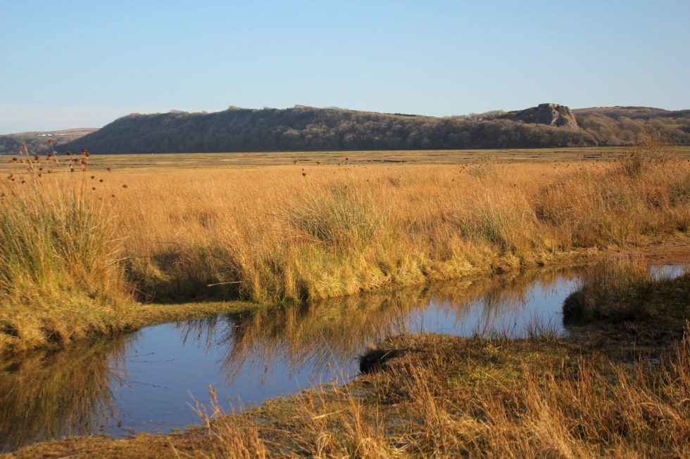
Here there is lots of bird song – blackbirds, ravens, rooks and we saw linnets, larks and tiny robins. On this side of Whiteford Point, it is very flat marshland. The sea is but a distant memory. This is clearly a river estuary and the river is far off beyond clumps of pine trees. The marshes are covered in lush grass and edged by yellow reeds. There are shaggy marsh ponies, who seem very small in comparison to their cousins who graze on Cefyn Bryn and Fairwood Commons.
Weobley Castle in the distance
As we get closer to Cwm Ivy, our starting point, we can see the village Llanmadoc spread up the hillside. We pass the late Medieval sea wall. There has been a sea wall at Cwm Ivy since the late 17th century when it was used to reclaim the marshland from the sea. The coastal path used to follow the wall round to Llanmadoc. Not any more, not since 2014 when the wall was breached by storms. The Welsh Government Shoreline Management policy stopped the National Trust from repairing the wall and breech. This ‘No active intervention’ policy of letting nature take its course was a controversial decision at the time. So this fresh water marsh has now returned to being a salt marsh. The breach is too big to jump over, there’s no bridge so you have to take a diversion at Cwm Ivy to reach the rest of old coastal path (which we did on another day).
The walk took us three hours, but as much of it was on sand so it was pretty tiring. We only took 4 biscuits with us, thinking that our lunch would see us through. I decided that I should have taken a couple of bananas and sandwiches too as you always need more food than you think you will need. If you don’t eat them I know of two helpers who will happily finish them off for me.
Biscuit? Yes please!
Next week: My final very long walk around the Gower Coastal Path.
Last summer I started my series of “Urban Minimal” paintings of the streets of Brynmill, Swansea. These paintings were my “Hollowed Community” project which were exhibited in the that year’s Madeinroath Festival. That’s not a typo, by the way. The festival organisers stipulate that you type it as one word Madeinroath, rather than three “made in roath”. Roath is a suburb of Cardiff, by the way. They also stipulate that the “in” in “Madeinroath”has to be in red too. It’s driving my spell checker crazy!
My “rules” for composition and painting this project were:-
No cars
2. No People
3. Bright light. There must be shadows – at diagonals if possible.
4. Simplified forms – there must be little detail in the final painting. I want to explore the interplay of the geometry of shadows and man-made structures – the tension between the 3D buildings and the 2D shadows. Simplified blocks of colour.
These rules worked well in an urban setting, especially with the sea light we have in Swansea.
Since then, I have been caught up in my Gower Coastal Walk.
By my calculations, I have three, maybe four more Gower walks to do in order to complete the length of coastline but other commitments are keeping me from finishing. Firstly, I have a pile of exam scripts to mark. I am rusty and I mark slowly these days. Secondly, a summer virus has made me feel under the weather.
I haven’t consciously applied the urban minimal rules in a non-urban setting. What’s the problem? The applying Rule #1. “no cars” and #2 “no people” rules is easy enough. As is #3 “Bright light”. Then there comes the difficulty. The second part of Rule #3 “There must be shadows – at diagonals if possible.” Walking late morning, mid-day day means that there are few long shadows and they are difficult to find on beaches too. Although, there have been a few.
[wpecpp name=”Three Cliffs at High Tide Large Mounted Print” price=”45″]
Finally, Rule #4 “Simplified forms – there must be little detail in the final painting. I want to explore the interplay of the geometry of shadows and man-made structures – the tension between the 3D buildings and the 2D shadows. Simplified blocks of colour.” I never really followed this rule to the letter as I thought details, such as window sills, and reflected light on glass, breathed life in pictures. It was knowing where to add detail and where to simplify that was important.
Limited edition large mounted print (free postage)
[wpecpp name=”Coloured Sands at Three Cliffs Bay Large Print” price=”45″]
Here, I have just been very cautious about going “too far” with this in a rural setting. But I have been edging that way, such as with my treatment of sand. Other aspects of my composition such as clouds and vegetation have not really been “minimal”, not in a conscious way anyway.
I think I need to challenge myself and make myself think about how I am tackling these subjects. I think my recent paintings of rural buildings (that’s cottages to you) has been much more successful.
Port Eynon Shadow (SOLD Oil on Linen Canvas, 46x38cm, unframed)
You may well say are just rural buildings instead of urban buildings. Yes, but they are stepping stones. I am still thinking about how I apply these rules when there isn’t a building in the picture!
In my last blog I quoted Welsh Historian and writer Wynford Vaughn Thomas, who called the Gower Peninsula “a secret people hug to themselves”. Brandy Cove may well be the secret that the people of Bishopston “hug to themselves” because it’s a short walk down a lane from the village for them, but the secluded Pwll Du Bay is much bigger secret as it is only accessible to the public on foot, horseback or bike. Yet, its just along the coast from Brandy Cove.
Brandy Cove from the Coastal Path
There are two coastal paths you can take here, the one that hugs the coast gets quite difficult in places (so bad you have to use all fours to get up one bit I seem to remember) so I took the path that trails further inland and higher, hoping it would be less arduous.
I checked on my map to make sure that this was a legitimate path, this time. Yes, there are two paths.
I have to retrace my steps back up the path back towards Bishopston and then take the path through a field and up into some woods.
There is no sea in sight but I trust the map (and I have walkers going up this path so must led somewhere good).
Once I cross the field and enter woodland, the lands rises but fortunately there are a series of steps cut into the earth. These steps are a godsend as well used paths easily become quagmires, even in what seem to be relatively dry conditions (as is the case with the woodland path around Oxwich Head) .
The step are like a my very own Gower-workout. I have to pause three quarters of the way up, I pretend to myself its to check the view, but really it’s to catch my breath. At the top there is a wooden stile with a helpful yellow arrow signposting the fact that this is a an official path although not the coastal path. As I come out of the woods and onto the top of headland and I am rewarded with a fantastic view of Brandy Cove and Caswell to the east of me and Pwll Du Cove to the west.
I think about stopping to eat a jam sandwich and a chocolate biscuit but it’s starting to cloud over a bit so I decide to press on to Pwll Du in the hope that it will still be sunny when I get there. Once I cross another stile the path becomes wide enough for 4×4 vehicles. This track is not open to the public.
Once upon a time this track was a lot busier as this was part of the only route between South Gower and Swansea. As I round the corner, Pwll Du Bay comes into sight.
Pwll Du Bay
Pwll Du, means “Black Pool” in English. I have puzzled over how to convey how the name it sounds (as I am not a Welsh speaker), you can either go to google translate and type in “Pwll Du” and then click on the little speaker icon or accept my shoddy anglo-approximation of “Poulff-Dee” which does not really do justice to the breathy Welsh pronunciation. I’d welcome other people’s suggestions. I sit down by the river in the sun to eat my “elevenses” which consisted of two jam sandwiches and two chocolate biscuits. The healthy banana was left for later.
Anyway, Pwll Du is a bit of a puzzle. Here’s what looks like a little Brigadoon in the the middle of nowhere that is very difficult to get to. In Pwll Du. There are three houses, and as you walk into the Bay, you pass another house on the right that has been abandoned.
Part of the answer is in the seclusion of the place. Like Brandy cove, this was a good place for smugglers to bring ashore wines, spirits and tobacco. This carried on in the 17th and 18th century until Prime Minister William the Younger slashed the sky high duties on tea, wine, spirits and tobacco and taxed things like bricks and tiles but also things that rich people liked such as gold and silver plate, men’s hats, ladies’ ribbons, perfumes, hair powder, horses and carriages, sporting licences and most famously, light, or rather windows. If you have ever wondered why the Georgians like to brick up window, it was a form a tax avoidance! The other part of the reason why a tiny community grew up here was lies in the the rocks; The limestone.
The limestone quarry was to the right of the houses
Pwll Du Bay was ideal, it was made of limestone and had easy access by sea. Limestone was quarried here on a massive scale and up top 30 ships could be moored in the bay at any one time. These thirsty visitors were enough to sustain at least two public houses, “The Ship” and “The Beaufort”. There are suggestions that there may have been as many a 5 pubs in the valley! The abandoned house I passed may have been either ‘The Bull’ or ‘The Star’ and a pub called the ‘New Inn’ apparently lay some way up the valley on the Swansea side of the river . The two pubs on the beach were later converted into tea rooms but are now both private houses. The Ship Cottage can be rented as a holiday cottage.
Pwwl Du’s seclusion also meant that during the Second World War some of the several German submarines that secretly sailed up the Bristol Channel used to surface, under the cover of night, to collect fresh water from Pwll Du. Apparently, but no one actually saw them doing this so it may just be a good story.
Ship Cottage, Pwll Du
Pwll Du Bay is a sand beach smothered in pebbles and is a popular destination for local secondary schools’ Geography field trips. There were two schools here when I visited.
Field work in action
The river that snakes its way down the wooded Bishopston valley seems to be get swallowed up by the pebbles. This is quite odd. I think that this might be what the geography students might be studying. There is a tiny footbridge that crosses the river before it vanishes under the pebbles. I love the wrought iron flourishes that make me wonder if they used to be someone’s garden gate in a former life.
Crossing the Bridge at Pwll Du
Once I had crossed the little bridge I climbed up another steep path with those Gower-steps cut into the earth.
At the top of the path is a holiday cottage – there is a choice here either carry on the road for a slightly shorter walk or follow the coastal in a large loop around the top of Pwll Du Head, called High Pennard. This used to be an iron age fort and is one of the highest headlands on the Gower. Here the Gower-steps are surrounded by delightful posies of primroses.
The view is well worth stopping for. To the east is Pwll Du Bay (below left) and to the east looks towards Pennard Cliff and Cefn Bryn, which is the name of that russet sandstone ridge off in the distance (below right). Just below you, looking towards Pwll Du, is a cliff known as Graves End. Its called that because its near where a ship called ‘The Caesar’ was wrecked in 1760. Its a very sad story because many of those on board who drowned had not chosen to become sailors but had become “press-ganged” . In other words, they were kidnapped by the navy and forced the serve on the ship. We know that some men from Port Eynon were recruited in this way and “press-ganging” was an occupational hazzard for all young men who lived and worked near the coast. Tragically, when “The Caesar” sank , many of the press-gang men were locked below deck and so died when the ship hit the rocks. They were buried in a mass grave at Graves End.
If you follow the road, you pass this cottage with old fishing nets and buoys in the garden.
On the otherside of High Pennard is Deep Slade, or Hunts Bay. This is a bay I hadn’t visited before this coastal venture. Day trippers are discouraged from driving up this way by “Private Road” signs. Apparently, it was once a sandy beach, but the sand has pretty much gone, leaving a very rocky cove. The loss of sand has been blamed on sand dredging in the Bristol Channel.
Hunts Bay at High Tide
It was at this stage in my walk I decided I needed to answer the call of nature. There seemed to absolutely no one around. So leaving my rucksack by the road I clambered over a five-bar gate and got behind a suitable hedge. Of course, it was at this moment I hear the clip clopping of a horse and after a few moment a rider (female, thankfully) comes by. She can see my bag and she’s craning her neck to see what I am doing. Drat. I feel very silly. After a moment’s pause I wave to her and shout out to her that I am answering the call of nature (those were not my actual words but you get the idea). This seems to satisfy her and thankfully, she moves on. I wait awhile before I clamber back over the gate. Fortunately, she’s long gone by then!
It’s a ten minute walk to Pennard Cliffs and the bus but I’ll describe this part of the Gower Coast in my next post.
One result of developing PTSD over 5 years ago is that for a long time I had limited energy. I honestly cannot tell whether my energy levels have returned to “normal” levels yet, or ever will. I find that it takes me a couple of days to recover from social events (and no, it’s not a hang-over as I don’t drink alcohol) or from traveling/visiting family or another town. Maybe, everyone my age is like, I don’t know.
I used to have ambitions or even a sort of “bucket list” of things I wanted to get round to doing, some time. I don’t much care for the term “bucket list”. If you haven’t heard about the term “bucket list”, it is a list of all the goals you want to achieve, dreams you want to fulfill and life experiences you desire to experience before you die. Here was mine.
Learn to surf
Learn to Meditate
Walk the coastline of Gower
Run a marathon
Walk the pilgrimage route to Santiago del Compostela
Visit Japan
I did learn to surf and I was very keen for a while, but I was never terribly good at it. I also once went on a 10-day meditation course. There was no talking for 10 days. Strangely, that was the easy part. I was running 20-25 miles on a weekly basis when my life took a swift left turn and everything ground to a halt in 2012. I am still active but I don’t run very far at all these days. I know I won’t be able to run a marathon unless I gave up everything else and just trained, ate and slept. There would be no energy left over for painting and making a living, so that’s out of the window. I cant afford to travel, not at the moment so it’s going to have to be number 3.Walk the coastline of Gower.
I have a curiosity about exploring the whole coastline of Gower. I know and love certain parts of it very well, such as Three Cliffs Bay. As a painter of the Gower peninsula there are parts that I have visited and painted many times. However, there are also parts I have not visited for years, and a few places I have never visited. I did plan and start to walk the Gower coast in 2016, but it all came to a halt as I tried to cope with the repercussions of being made redundant from my teaching post where I had worked since 1999.
So start again. Here are my rules
Travel in a clockwise direction around the Gower coast
Travel by public transport and by foot.
Walk on sunny days.
Erm, that’s it.
I will document the walk with photos, sketches, and paintings. However, I am nervous about this. The big challenge for me will be in terms of my energy levels. The whole coastline is something like 38 miles long and I know I will have to divide that up into many short walks that will be very tiring for me. I will probably need a week to recover in between walks. I am nervous that I won’t have the determination to finish this, or something will happen to put me off, such as in 2016 when I got part way through in 2016 and gave up. I hate not finishing things.
Coast Watch Station, Rhosilli
It will also be challenging for me mentally. When I was younger, I did many brave things on my own. I traveled around the UK and spoke at Academic conferences, I even traveled to Texas very soon after I passed my driving test and drove a hire car. The PTSD has had the result of reducing my life and what I do, either because I get tired or because I am fearful. PTSD means that my brain goes into anxiety mode very easily. My head will worry about the coming back before I have even left the house. I will convince myself that none of the buses will arrive and I will be stranded in the wilds of the Gower and have to sleep under a bush. Yes, it all sounds stupid when I type it, but that’s the sort of thing that keeps me awake at 3am in the morning.
So I will have to prepare well, take a load of bus timetables and set off early and challenge the fear. A few weeks ago I panicked and jumped into the sea, thinking I was about to get washed off some rocks. Bizarrely, the evidence has given me confidence. The boots and I survived. It was uncomfortable but the boots dried out on my radiator. So I will make a start this week, even if it takes months to complete the challenge.
Before our visit to Fall Bay, Gower, I’d read online that it was “one of the hardest bays to reach on the Gower Peninsula”.
My curiosity was piqued. The walk from old Great Pitton Farm, to Mewslade seemed easy enough. The coastal path climbed up past Jacky’s Tor, Devil Truck and Lewes Castle until it reached Fall Bay. Not so difficult, I thought. That was until I attempted the climb down to the beach!
The beaches at Brandy Cove and Great Tor Bay also require you to clamber down some limestone rocks before you reach the sandy beach. This path, however, was much more difficult to navigate, though. The way became very narrow and I had to wait several minutes to let two energetic families come past. Still, I have this idea that one must suffer to some degree in the creation of your art so I carried on. As I started my climb down, the “path” became much tighter and steeper as the way down twisted and the rocks were worryingly smooth. The final descent was very difficult, made much more treacherous by slippery rocks. I was amazed that I didn’t twist my ankle! So no wonder, the “beach is never crowded”.
The day had become overcast by the time we reached the beach. Tears Point rises above the beach at the west end. Worm’s Head and Rhossili, is just round the corner, but out of view. The grey light meant that the waves looked greener and the cliffs more red/orange. I was drawn to painting the light through the breaking waves, where the sand and sky is reflected in the narrow part of the wave. I also loved the chunkiness of the cliff where it meets the sand and how the surf swirled around it. I got my feet and trousers wet more than once!
Thankfully, it was much easier to climb back up the path than it was coming down.
There is a unique architectural gem, perched upon the high cliffs above the shores of the north Derry coastline. High on the cliffs is an elegant roman-style round temple; a beautiful rotunda. It is a wonderful surprise. There is none other in Ireland. It looks out across Lough Foyle to Donegal to the north and on a clear day the Scottish Isles can be seen to the north-east. This remarkable building is Mussenden Temple built by the Earl Bishop Frederick Hervey of Derrry.
Inspiration from the Sperrins. These mountains are mostly moorland and blanket bog. It’s a sparse roling landscape. Populated by sheep, bog grass (Eriophorum angustifolium) and muddy SUVs, and farmhouses, old and new.
Some old farm buildings have long-been abandoned by people but are still used for farm equipment and shelter for sheep. So long as there is a tin roof, the walls will last years and years.
The robots are coming for our Art. Many artists are losing their ability to make a living thanks to AI Art and we will all be poorer financially and creatively for it. Here’s why its a problem and what we can do about it.