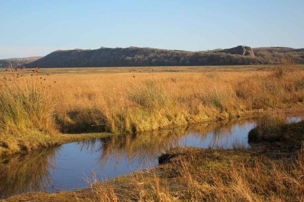
We didn’t get an “Indian Summer” in September, which when we usually get one in Wales. What we have had, instead, is a series of sunny days in late October/early November. The sparkling autumn light is stunning. From a painter’s point of view is more interesting than summer light. So last week I drove down to Three Cliffs Bay to enjoy the light. I was surprised by the dark blue of the calm sea. It was quite a different colour from the summer sea.
Three Cliffs Autumn Light
I was hoping that there would be plenty of orange bracken and there was. Not on the slope of the the Three Cliffs, as they are covered in grass, but on the slopes of Cefn Bryn, in distance.
Painting of Pobbles Bay, Three cliffs, Gower
These colours sum up the Welsh landscape for me. In fact, I think I like the Welsh landscape in autumn/winter best. The red and the green of the bracken and the grass also put me in mind of the red and the green of the Welsh flag.
Welsh Flag (an interpretation)Light on Great Tor (Gower)
I find it ironic that there’s less light around but its better quality, from an artists’ point of view. I still have not adjusted to the clocks going back last month, and I am still waking at 5 -5.30am! It does not seem to matter what time I go to bed, I awake in the dark feeling ready to rise. So I get up and here I am tapping away at my computer in the dark waiting for the sun to rise. Soon I will have to get my SAD lamp out to stop the slow slide in winter gloom. Before, you ask, yes, SAD lamps work for me.
Does anyone else suffer from this problem? Does anyone have any tips for sleeping in later?
Update: I sat with my SAD lamp on for 20 minutes around 7 pm last night and it seemed to help me go back to sleep when I awoke at 4.30 am, and I didn’t get that “wake up” surge of hormones til 6.30. A definite improvement.
I have a confession to make. This walk was done out of sequence. It was done on March 28th, on the day the clocks went forward. That seems a long time ago. It was a beautiful day but very cold. Back in March when I had only got as far as Pennard and Three Cliffs, I sort of panicked. This was because I could not make head nor tail of the bus timetables and doubted that I could make it around the coastal path by public transport. So my husband, Seamas, suggested that we drive to the most out of the way places in Gower and do circular walks and then I would fill the rest in with public transport. Another blogger has since directed to the invaluable traveline.info which helped me made sense of the bus connections, when the online bus timetables seemed incomprehensible to me.
So we decided to go to Whiteford Point. It is a mini-peninsula off the northern corner of Gower peninsula. This is seen by many as the wildest and most remote part of Gower. We drove along the narrow lanes to the northern tip of Gower, to the village of Llanmadoc. Llanmadoc Hill is quite imposing as you approach it from the South East. I generally think of Gower as having two big hills (Cefn Bryn and Rhossili Downs) but Llanmadoc Hill at 152m is pretty high too. You get a sense of how it dominates this corner of the peninsula from Cedric Morris’s painting of it in 1928.
If you drive through the ajoining villages of Cheriton and Llanmadoc, you will come to Cwm Ivy Court Farm.
Far Hill Above Cheriton, 2016 (SOLD)
On the opposite side of the leafy lane is an open gate to a field, which acts as a temporary but well-used car park. When we arrive after lunch, it is pretty full. There is an honesty box built into the wall for walkers to put their car park fee of £1. Considering the National Trust charge up to £5 at Worms Head, it seem like a bargain.
We then walk down the lane past a small number of houses, the last one has a ice-cream tub of drinking water for passing thirsty dogs. Once you pass through the five-bar gate you are on National Trust land.
In 1953 it was designated a Site of Special Scientific Interest as it is an internationally important feeding ground for wading birds and wildfowl. Not long after in 1965, Whiteford Point came up for sale by auction and there was great worry that it might fall into the “wrong hands”. Fortunately, the National Trust was able to buy it. This was the first property to be acquired as a result of something called “Enterprise Neptune”, which was the National Trust’s campaign to protect Britain’s coastal heritage. So this area is a now a nature reserve owned by the National Trust.
Whiteford Point
If you follow the lane down hill there there is a choice.
Straight ahead is are the marshes and sands dune and eventually open beach that joins with the wide expanse of Broughton Bay, to the west. If you take a turn right through another wood gate you are then in Whiteford Burrows.
Pine Trees
Whiteford (pronounced Whit-ford) is apparently derived from the Danish ‘Hvit-Fford’, meaning white ford. The Vikings left their mark on the outward-facing west coast of Gower, in their placenames at least. Look at left side of the map above. Worms Head, Burry Holmes and Whiteford are all derived from Scandinavian words. Perhaps, the Viking who traded and marauded up and down the Bristol Channel as late as the 11th Century, only ever gave names to the landmarks they could see from the water, but they certainly stopped by at Swansea, whose name is also Scandinavian in origin. It means “Swein’s Eye” or Island. There used to be an island at the heart of Swansea until the Victorian diverted the river. The Welsh call it “Abertawe” which means the mouth of the River Tawe.
Once into the the nature reserve you pass the very cute Burrows cottage, which used to be a forester’s cottage (you can rent it) and further along the path Cwm Ivy Bunk House (which you can also rent by the night). There are no other houses on Whiteford Point. It is a very lonely place from a human point of view. It is however, full of undisturbed wildlife.
Either side of the path are many grand pine trees, smothered with massive pine cones. They are Scots and Corsican pines. I think gives the place a Mediterranean air. They were planted from the 1930s onwards. There are hundreds them, thousands. I have read somewhere that there were 20,000 in the 1970s. They help certainly help stabilise the dunes and stop the sand blowing away. You can see these trees from miles around.
The pine trees as Seen from Hills Tor
I get excited when I see what I think are public toilets in a very tasteful wooden chalet on the path ahead. I am always looking for “proper” places to relieve myself instead of the inevitable bushes.
Not toilets!
Ah, what a fool, I am. As I get closer I realise my mistake. Its not a nice artisan toilet block. It’s a bird hide for watching wildlife on the salt marsh to the right. The door is open and we can see its empty. So we go in and peer across the flat marsh. We don’t have the patience to wait.
[wpecpp name=”Woods at Whiteford Sands Large Mounted Print” price=”45″ align=”left”]
Once we have passed the bunk houses we follow a sort of path through the pine woods, climb a stile over a wire fence and we are on the burrows. Whiteford Burrows, or sand dunes, cover an area of three square miles. It’s bigger than it sounds. There is a vast expanse of beach on the other side of the dunes, leading out along the edge of the Loughor Estuary.
It was a long walk along the beach – it a very empty beach. Two miles of it to Whiteford Point. People are small dots off in the distance.
Whiteford Sands (towards Broughton Bay)
The landscape here is reduced to stripes of colour: Sky-sea-beach-dunes. The tide is out and the sea is very distant.
Whiteford Sands
I am slightly unnerved by the signs saying informing me that Burry estuary was used as a shelling range by the British army during World War Two and the unexploded bombs are still likely to turn up in the sand dunes. Yikes! I take this seriously, I remember a World War Two bomb that was recently found in the near by Loughor River although I can’t find the story online. In 2015 a family found what they thought was a “buoy” covered in barnacles on the northern side of the estuary, at Burry Port. The kids spent quite a bit of time jumping on the strange object and had their picture taken next to it. You have probably guessed it by now. It wasn’t a buoy it was an old Second World War bomb. The beach was cleared and the “buoy” was blown up.
That’s NOT a buoy!
Shells still turn up at Whiteford Point too. In September 2014, for example, some sixty shells were exposed at Whiteford Point, and bomb disposal teams were summoned to deal with them. The firing range was also used on a regular basis for the firing of chemical shells during the Second World War, including ones containing mustard gas. Earlier this year there were reports of the Ministry of Defense blowing “something” up earlier this year in the Loughor Estuary so I don’t fancy taking my chances and stick to the beaches. I expect most people do the same and the dunes are left undisturbed.
Beware Unexploded Shells!
At Whiteford Point there is a curious cast-iron light house. It is the only wave-swept cast-iron tower of this size in Britain.
Whiteford Lighthouse
It reminds me of a giant bird cage. The local seabirds, gulls and cormorants use it as a convenient perch. It is not close to the beach but it can be reached at low tide, although its a long rocky walk over the seaweed-covered rocks.
[wpecpp name=”Wave-Swept Iron Tower Large Mounted Print ” price=”45″ align=”left”]
It reminds me that much of the Gower coast was always hazardous to shipping. This area in particular was very treacherous and a large number of ships were wrecked at both nearby Broughton Bay (where ships used to be able to anchor in the bay until it was silted up in mid-nineteenth century) and here along Whiteford Sands.
Tragically, the lighthouse failed to prevent a one of the biggest shipping disasters in the area, which took place in January 22nd 1868. On this calm winter night 16 ships out of a fleet of 19 sailing out of Llanelli, sunk in a single night and possibly up to 30 or more lives were lost. These ships had been towed out of Llanelli by steam tugs. They had been cast off and rounded Whiteford point, aiming to clear Burry Holmes with the ebb tide. This was in the age of sail and the ship needed a breeze to power them on their way.
Unfortunately, the wind died and a heavy swell tore the ships from their anchors and drove many of the ships onto the rocks at Broughton Bay, or smashed them against each other. As it was such a quiet night, no one on shore had any idea of the disaster that was happening in the estuary. A large buoy and chain and the remains of a wooden hull near Whiteford Point are all that is left of these ships.
Although the beach seems utterly deserted the air is filled with the high pitched piping sounds of little wading birds.
They are too far off to identify with any certainly, but I think they might be oyster catchers. We are feeling tired after our long walk along the beach. We sit on the edge of the dunes for a rest and chocolate biscuits, listening to the euphoric trilling of skylark song.
Around the tip of Whiteford Point the path reappears and winds its way along the edge of the pine woods. The path is very water logged and at many points it resembles a series of small still lakes rather than a path. So we hop from muddy patch to muddy patch.
Looks like a lake but its the path!
Here there is lots of bird song – blackbirds, ravens, rooks and we saw linnets, larks and tiny robins. On this side of Whiteford Point, it is very flat marshland. The sea is but a distant memory. This is clearly a river estuary and the river is far off beyond clumps of pine trees. The marshes are covered in lush grass and edged by yellow reeds. There are shaggy marsh ponies, who seem very small in comparison to their cousins who graze on Cefyn Bryn and Fairwood Commons.
Weobley Castle in the distance
As we get closer to Cwm Ivy, our starting point, we can see the village Llanmadoc spread up the hillside. We pass the late Medieval sea wall. There has been a sea wall at Cwm Ivy since the late 17th century when it was used to reclaim the marshland from the sea. The coastal path used to follow the wall round to Llanmadoc. Not any more, not since 2014 when the wall was breached by storms. The Welsh Government Shoreline Management policy stopped the National Trust from repairing the wall and breech. This ‘No active intervention’ policy of letting nature take its course was a controversial decision at the time. So this fresh water marsh has now returned to being a salt marsh. The breach is too big to jump over, there’s no bridge so you have to take a diversion at Cwm Ivy to reach the rest of old coastal path (which we did on another day).
The walk took us three hours, but as much of it was on sand so it was pretty tiring. We only took 4 biscuits with us, thinking that our lunch would see us through. I decided that I should have taken a couple of bananas and sandwiches too as you always need more food than you think you will need. If you don’t eat them I know of two helpers who will happily finish them off for me.
Biscuit? Yes please!
Next week: My final very long walk around the Gower Coastal Path.
Please note that this post was written in 2018 and there was a massive rock falls on this section of the Gower coastline in 2019.
I realise now that my Gower Coastal Walk may have been easier if I waited until summer to do it. It was probably because my 2016 attempt ran into the sand that I have become a bit obsessed with getting it done. I also have work-related commitments in May and June that mean that I won’t be able to go walking during the weeks and I may be too tired to do much at the weekend. So what? Well, cold weather and wind is fine – lots of layers and a padded coat with a hood see to that (see illustrative photo to the right).
The mud’s quite different. It can be quite a hazard. My first walks from Limeslade to Brandy Cove, were reasonably mud-free. From Pwll Du onwards, however, mud becomes a frequent peril. It’s just as tiring as sand to walk through but offers the excitement of the possibility of a) slipping and falling on my backside or b) slipping and twisting my ankle. Thankfully, neither of these actually happened. I have taken many photos of my muddy boots. Here’s a selection.
I don’t know why I never see other walkers with mega muddy boots like mine, maybe there are more nimble. Anyway, more of mud and other hazards later.
I’ll start with a lovely mud-free church. St Illytd’s church, Oxwich, is in the most beautiful setting. The first painting I ever sold was of St Illtyd’s Oxwich. Unfortunately, I didn’t keep a decent photo of that painting. St Illtyd’s nestles in the woods by the sea, just short walk from the village of Oxwich. At high tide you can hear the waves just the other side of the graveyard wall. The vicar used to live an rectory even closer to the sea (see Thomas Rothwell’s painting below) but it’s gone now, unfortunately, destroyed by the encroaching tide.
Rothwell, Thomas; “The Old Rectory, Oxwich” (1790)
The very first religious building was built here in the sixth century. St. Illtyd, a native of Brittany, is meant to have built a small cell here. Illtyd is a very significant figure in Celtic Christianity. He is also known as “Illtud Farchog” in Welsh meaning, “Illtud the Knight”.
St Illtyd
You may not have heard of this Celtic saint but he was very active on the Gower peninsula and elsewhere in South Wales. Legend connects him to the legendary King Arthur, claiming that he was the King’s cousin and served him as a young soldier. Even if this is not true, it was not unheard of for knights to get up their fighting life for spiritual conflict and enter a monastery. The village of Ilston not far from Oxwich is named after him as well its church. There is also a church dedicated to Sts. Illtyd and Rhydian in the village of Llanrhidian in North Gower. There are churches and schools which bear his name all over South Wales and in his homeland of Brittany.
Illtyd later left Gower and founded a very important monastic school known as “Cor Tewdws”, in Llanilltud Fawr (Llantwit Major) which is further east along the Glamorgan coast. His school is believed to be Britain’s earliest centre of learning. At its height, it had over 1000 pupils and educated many of the great saints of the age, including Saint David, later patron saint of Wales, Gildas the Historian, and Samson of Dol, founder of a monastery on Caldey Island.
St Illtyd’s Oxwich
The church you see today, however, is not Illtyd’s construction, although the font inside apparently is. Most of this building was rebuilt in the thirteenth century. What is so interesting about the design of the “new” church is the battlemented tower, which looks more suited to a castle that a church. Almost all the churches in Gower have these fortified towers. Many Gower churches, nine to be precise, were owned by a crusading order called the “Knights Hospitallers” but the design has nothing to do with crusading in foreign lands and everything to do with homeland security.
St Illtyd’s Oxwich 2018
In the 12th and 13th centuries, the Severn Estuary was riddled with pirates. In the 12th century Viking raiders – based in Ireland, the Isle of Man and the Scottish Isles – still ravaged the Irish Sea coasts. Lundy Island, far out in the Channel but within easy reach of the Gower by sea, was a pirate lair during the first half of the 13th century. Raiding vessels could easily send crews ashore to take animals and even people for ransom or slavery. Oxwich church tower, with its battlemented roof, could be used as a look out and as it was built of stone, it they could be used as temporary refuge against robbers long enough for help to arrive.
Oxwich church, then, has a very ancient history and setting which is not as peaceful as it first seems. Its graveyard is also reputed to be haunted by a supernatural beasts known as a “ceffyl dwr” or water horse. The water horse is a horse-like creature, which was apparently been seen walking on its hind legs, and then vanishing down the well c.1894. The first written account of a sighting appeared in Rev. J.D. Davies’s “History of West Gower” where he tells of his elder brother and father seeing the beast one night, after they had been fishing in the bay. In a letter published in the Swansea Evening Post in May 1963, Mr David Lewis George of Cardiff wrote, “I recent years a similar white form was seen gliding over the graves in Oxwich churchyard around midnight by an elderly person of unquestionable integrity “, thus making at least three witnesses who claim to have seen the ghostly apparition of Oxwich churchyard.
We did not see any horse-like creatures on our walk. Once again, I am accompanied by Biddy and Mitzy our dogs and Seamas, my husband. Once we passed the church we are presented with a very long flight of steps cut into the earth.
Although tiring to climb, these steps are a godsend to walkers. We follow the path through the wood and then climb a lot of steps back down the hill.
Here among the trees are cliffs. They are not obvious. The trees largely hide them but they are a significant height and there are warning signs. I mentally sniggered at the signs when I first saw them as I thought they were over the top. Turns out they are not. The sun then went in.
Although there are fences along the top of most of the wooded cliffs, not all of them are fenced off. We were passing another family on the path and Biddy, our Collie-cross, walked towards what looked like the continuation of the path downhill. It was no such thing. It was a cliff edge. Idon’t know if was my yelling her name at the top of my lungs, or her natural good sense but Biddy, thank God, paused at the edge.
Cliff edge masquerading as a path
Not all dogs have sense. A friend’s dog was killed when he fell off a cliff in West Wales. Several years ago our dog, Dottie, the wired haired terrier, was killed on the main road near our house in Swansea when she ran away from me. Actually, she was running towards the beach. She had bolted out of the park, disregarding my calls. I tried running after her but she was too quick, I could not catch her and there was no gate on the entrance. She never got to the beach. There was a busy main road was in the way. The incident broke my heart and cast a long shadow. It is still a very painful subject for us.
So, we peered over the edge and thanked God that Biddy had stopped in time. If she had gone over the edge she would have probably been killed. I have watched her behaviour on walks since, and realise now that she probably paused from natural caution. Dottie was never cautious. So with that near miss playing on my mind and later on that night, I kept replaying that moment when I was shouting at her to stop in my head, we carried on along the path.
Mud and my unharmed walking companions
The path is very muddy. The colour reminds me of chocolate. It is very slippy. This is the sort of place that I worry I will twist my ankle. I don’t; I just get very muddy boots. For a lot of the path it is so thickly wooded the sea is hardly visible. Occasionally there are gaps in the trees and if you were feeling agile and adventurous you could climb down to the rocks by the sea.
Eventually, after a long slippy walk, we leave the trees behind and we have a clear view of Three Cliffs across the bay.
Three Cliffs from across Oxwich Bay
We can also see Devon across the Bristol channel. The headland is rocky. Very rocky.
I read the warning sign with some trepidation. They seem fair warnings. I did see an adder one summer years ago at the top of Tor Bay. He was crossing the path. I just stood back and let him go on his way. He was not interested in us.
Adder (not the one I saw)
Historically, the main hazard around here was to shipping. If you look at the Thomas Rothwell’s 1790 painting of the old rectory again, you can see how rocky Oxwich Bay is along the east side. The headland is even rockier. It not surprising, then, that the coast of Gower has seen something like 250 shipwrecks. Maybe this is due to the high tidal range in the Bristol Channel. More likely it was due to a rocky shoreline and poor weather. Oxwich Bay and Oxwich Point witnessed the floundering and wrecking of something like 15 ships in just under 50 years from 1822-1866. Wreckage from ships that had sunk further along the coast would also be washed upon the sands of the bay.
The path above the headland is relatively easy to walk along here. It is flat and dry.
We stopped for jam sandwiches and biscuits, looking out towards the one-time-home of pirates, Lundy Island. It’s a slither of blue on the horizon.
Biddy (with her expressive big ears) and Mitzy – 100% concentration on that jam sandwich
The sun is long gone and the sky is covered in clouds. There’s a cold wind. I now regret not bringing my woolly hat but take some satisfaction in the fact that I have my warm padded jacket on. Craggy rocks loom above the path to Horton.
The path to Horton is long but reasonably straight forward.
There are a couple of detours around fields. These detours look like they have been here for years.
The final detour involves a long steep climb up a valley called Slade, just by a sandy slither of beach.
By the time we reach Horton the tide is retreating. My parents tell me we came on a family holiday to Horton when I was two years old. I don’t remember it. It must have been a happy holiday because my younger brother came into the world nine months later!
Horton is separated from Port Eynon by a short stretch of sand dunes. Although they are so close they are two very distinct communities. Horton, I suspect is slightly posher than Port Eynon. At its heart are some grand Victorian villas. There are also a series of very beautiful exclusive houses with long zig-zagging steps down to beach. That said a large detached house in Port Eynon can cost as much as £800,000 – £1.1 million (or US $1m -S1.5m). Not exactly cheap.
House at Horton
Yet, it’s all a bit of façade because behind both Horton and Oxwich are a number of vast large parks, full of static caravans. These static caravans cost upwards of £35,995 to buy and you pay site fees of £2-3000 each year on top of that. (that’s about US $50,000 and annual fees of US $3000-4000). These are a bit like American trailer parks but you are not allowed to live in them all year around, they usually close for 4 months over the winter.
Horton
The sun is shinning for my next walk from Port Eynon and get up the courage to get on the bus again and even make a connection.
I am shattered. My legs are so stiff, I can hardly walk up and down stairs. I have been this way for days. My problem is that I can do activities, running, yoga, walking but often “pay for it”afterward. I don’t really understand how much this is to do with life post-PTSD, if at all because you never fully recover from PTSD, but you learn to manage with what you have. Maybe it’s middle age. Maybe I do too much or just can’t tell when I am doing too much. I am pig-headed. When I see a sunny forecast I am looking at maps and bus timetables and planning my next walk.
OK. A word about bus timetables. The ones for Gower are very confusing. The ones for the Swansea (including Limeslade, Caswell and Pennard Cliffs) are great. I understood them. The buses ran frequently. Once you get past Pennard Cliffs and change bus companies, however, the timetable becomes impenetrable. I have spent hours looking at the little rows of numbers and columns of place names trying work out how they connect or don’t. I have woken up in the night worrying how I am going to complete this coastal walk.
It seems that I can get to several of the places I want to go in the morning OK; Oxwich, Rhossili, Llangennith (if I can get to the bus stop at 7.40am). It’s the coming back that’s a much dodgier affair. There seems to be one bus in the late afternoon. Maybe. If I have downloaded the correct timetable from the internet as there often seem to be several versions and I am not sure when one is the one the bus drivers will be using (see my earlier blog for my rant about lack of tourist or bus information.in Swansea). Part of the problem is that I am trying to get to places outside the main tourist season June-August when there are slightly more buses running. Maybe this wouldn’t matter if I knew that I could walk 20 miles in a day, or 11 miles, but so far I have only done 3 or 4 miles and found them pretty tiring.
So this is a long-winded way of saying that I have broken my rules. Just to remind you. They are:-
1. Travel in a clockwise direction around the Gower coast
2. Travel by public transport and by foot.
3. Walk on sunny days.
So Rule No. 2. I’ll fess up. For some parts of the coastal walk, I got in my car and drove to the places that I was struggling to figure out the public transport links for. That was until Ceri from woman walking blog recommended traveline.com to me.
Map of Oxwich Bay
Rule 1. Clockwise direction? Not always. This particular walk was done in two parts. The first from Tor Bay in a westerly direction (with both human and canine company) on a breezy, sunny day but the second part was done from Oxwich (alone) in an easterly and thus anti-clockwise direction (and looped back to my car). It wasn’t very sunny. So I broke all the rules on that day. It didn’t feel good but nevermind. I’m just doing it badly. It’s a coping strategy. I came across it recently. The thinking goes, if you are paralyzed by anxiety and a fear of failure: “Just Do It, Badly.”Once the summer bus timetable is action, perhaps I’ll be a perfectionist and do it “properly”. We’ll see.
I’ll pick up from last week’s blog about Three Cliffs Bay. The climb up from western side of Three Cliffs Bay itself is pretty tiring as its very sandy but the view at the top is worth every bit of the struggle.
Top of the Cliffs above Pennard Pill
At the top is an Iron Age fort. The Iron Age was a very long time ago – about 2,500 years. It has a fantastic view of Three Cliffs Bay (the ramparts are covered in primroses).
Following the coastal path around the very windy edge of the cliffs, you eventually reach around the top of Great Tor and Tor Bay below.
Path around Cliff TopsThe Spine of Great Tor
At low tide Tor Bay can be reached by walking along the beach from Three Cliffs Bay in the east and also from Oxwich Bay in the west, but at high tide the sea cuts off the little bay. It then can only be reached by a path down from the cliffs. This path is very sandy at the bottom end making it considerably easier to walk down than up it! This is a detour and not part of the coastal path walk!
Down to Tor BayEmpty Beach at Tor Bay
It was a windy day and the clouds and their shadows were racing across the sands. It was really delightful watching the light and colours change on the cliffs tops and beach. We saw only three people and one day on this mid-week walk.
Light and shadows on Great Tor
My two canine companions Biddy and Mitzy had a great time, especially when they found something really stinky to roll in, on top of Little Tor. There were streaks of “it” in their coats. Like brown dog-highlights. Urgh! It smelt really bad even out in the fresh air, despite a dip in the sea. It was even worse in close quarters in the car home. Needless to we drove with the windows open and they were bathed as soon as they got through the front door with lots of lovely dog shampoo.
My walking companions (the ones with 4 legs are smelly)
On the path above Tor Bay is a curious stone building with two archways going nowhere. A useful shelter if you are caught out in the rain or in a hail storm was we were a few months back. It’s actually a lime kiln. Gower is dotted with these buildings in which which limestone was burnt or calcined to produce quicklime.
The Lime KilnLime Kiln (Close Up)
The path then undulates along the headland until it reaches little five bar wooden gate with a wonderful view of Nicholston Burrows (dunes) and Oxwich Bay on the other side.
Oxwich Bay & Nicholaston Burrows
The path continues until you are given the choice of carrying on down through the woods on the right on down to the sandy beach on the left. I took the long sandy path through the dunes down to the beach, the smell of the sea calling me all the way. If the tide is out you can then loop left round to Tor Bay or right and walk along Oxwich Bay.
Oxwich Bay is a wide expanse of water and sand. It’has a sandy beach which is about 2 1/2 miles long, flanked by sand dunes, patterned by a maze of tracks. Beyond the dunes lie lakes, woodlands, salt and freshwater marshes. Apparently, it’s rare to have so many different habitats in such a relatively small area in the UK. They are all part of the Oxwich nature reserve.
The beach and the dunes are bisected by Nicholaston Pill, a small river that flows out from the marshland and reeds. I’d forgotten that there’s a little wooden bridge over the river, tucked away in the dunes.
There was a middle-aged couple sitting on the sand dunes with their dog. I stopped and we had a long chat, in which we discussed in quick succession; the weather, buses, Cardiff, Swansea’s one-way traffic system, the council, the Slip Bridge and buses again.
Some very large flotsam
Eventually, after a very long walk on soft sand, past much flotsam, I reach the end of the beach. There lies the village of Oxwich. In summer this is a very busy beach. This is the second largest beach on the Gower peninsula after Llangennith. There is a large car park, a flat beach, a cafe, and toilets so it’s rather popular with visitors, apparently, an incredible a quarter of million of them each year!
There are several caravan parks within walking distance too. When we first came to Gower we used to come here and I once attempted to surf here. It didn’t go well as I paddled too far out and got scared.
Oxwich Bay Hotel
Set just a step back from the beach is the Oxwich Bay Hotel. It is an imposing building, its steeply pitched tiled roof reminding me of French architecture for some reason.
The tiny village Oxwich lies on a road leading inland from the sea. That because this was not a fishing village. It probably won’t surprise you to learn that the woodland areas of Oxwich were quarried for limestone and exported, using Oxwich bay as a small port. So the cottages of Oxwich were once the homes of the local quarrymen. At the start of the Napoleonic Wars, in which Britain declared war on France, the Royal Navy was forcibly “recruiting”, or press-ganging, men from communities situated along the British coast. This included the Gower coastline. Late one Thursday evening in October 1803, the HM Press Gang called at Oxwich and took 5 sailors, one of whom was a ship’s boy, who had happened to come ashore from a merchant vessel.
Once upon a time, all the houses in Oxwich would have been thatched. Now few are except the cottage that has gained fame for being the place the Methodist Minister, John Wesley once stayed in 1764. It was known as the “Nook”. The well-traveled Wesley was impressed by the people of Oxwich as he noted in his diary that “all the people talk English, and are in general, the most plain, loving people in Wales’. There is no pub in Oxwich and it has been suggested that the influence of John Wesley may have had a bearing here!
John Wesley’s Cottage, Oxwich
So I broke the rules (including the staying on the official coastal path one) but I have made it past my “block”. I have had to pay the price as must have walked for about 5 miles on the sand. Hence the very stiff calves. Maybe, next time I will take the woodland walk! I did it badly today but I did it.
Next time I will walk Oxwich Head and experience mild peril.
Three Cliffs Bay never fails to disappoint. It does not matter how many times I see it. The sight of it always causes an involuntary intake of breath; when I see it from the road, or from the slopes of Cefn Bryn (the long hill that stretches across the Gower Peninsula) or from Pennard Cliffs.
It is particularly spectacular at high tide in the morning light. It is probably the one beach I have visited most often and certainly painted most often, on the Gower coast. It is yet another beach that requires a bit of a walk to get there. There many different routes you can use. I am going to talk about the route I took on this journey along Pennard Cliffs. The village of Pennard lies a short distance to the north of High Pennard, rather confusingly, its the well-heeled village of Southgate that actually skirts the limestone cliffs of Three Cliffs Bay. The bus from Swansea stops at West Cliff, next to a coffee shop, restaurant and shop-cum-post-office. There is also a sizable National Trust Car Park. For years I have parked my car in the car park and walked west to Pobbles Bay and the spectacular views of Three Cliffs, never realising that I was missing a gem, just a bit to the left of the car park.
Three Cliffs Bay
It was only because I was walking along the coastal path, from Hunts Bay, that I came across it. The walk itself was relatively easy as the land was flat although covered in gorse bushes. I had thought this part of my walk would be relatively boring as I could not easily see over the cliff edge but I was accompanied by the wonderful rising song of skylarks. The gorse seemed to be home to many birds and flowers; blackbirds, larks, posies of primroses and the golden stars of the celandine (I think). I loved looking at all the wildlife. It was the presence of a bench that alerted me to the fact that there might be some worth looking at nearby. I hadn’t seen a wooden bench since Brandy Cove (there’s one above the bay). Looking at my map, I realised that I was at High Tor. I approached the cliff edge, with great caution is it very high and I do not like heights as my legs go wobbly. What a view! WOW. It was a wonderful panorama of Oxwich Head, Oxwich Bay, Tor Bay, Three Cliffs Bay, craggy limestone cliffs topped off by Cefn Bryn. I made many exclamations. I sat down to eat some sandwiches and drink in the fabulous view. How had I not seen this before?
View From High Tor towards Three Cliffs BayView From High Tor
I had missed this view because I had always been in a hurry to get to Three Cliffs Bay. What I usually do is hurry along the coastal path along the cliff tops. You pass many beautiful houses set back from the cliff edge on the right, envying their position/view.
There is a gravel road for much of the distance but that ends and then you are faced with a muddy footpath or an even muddier bridle path (path for horses and their riders). The path crosses grassy headland and many gorse bushes, with a golf course to the right.
Then you get your reward. Three Cliffs Bay. It is a wide split in the limestone cliffs, sliced open over thousands of years by the meandering stream, known as Pennard Pill. It takes its name from the three sea cliffs that jut out into the bay. I have painted this view many times over the years and my treatment of the scene has also changed.
The beach to the left of the three limestone peaks is called Pobbles Bay. At high tide, it is separated from the main beach but at low tide, you can reach it by foot along the sand.
Human Concern
This beach is popular with dog walkers, some of whom brave the waters here. I say “brave” because it can be very dangerous to swim at high tide, due to the strong rip currents.There are large warning signs on the other side of Three Cliffs Bay. Sadly, people have died swimming at Three Cliffs Bay; three in the past 4 years. Apparently, it is relatively safe at low and incoming tides. Fortunately, there are full-time lifeguards at the main Three Cliffs beach during the Easter & Summer holidays and weekends in May and June. I am not sure I have ever gone in the sea here. I prefer Brandy Cove or Port Eynon.
The path to Pobbles BayShadowed Rocks at Pobbles Bay
The “Burrows” or sand dunes make for tiring walking but its worth the long climb to the ridge behind the three cliffs.
Depending on the condition the tide may be a long way out and you have a view of a vast stretch of pristine beach, and the snaking Pennard Pill stream feeding into the sea.
Pennard Pill
A High tide you have the excitement of the incoming sea waves.
The path sweeps around the cliffs tops back inland along an undulating path towards Pennard Castle.
Pennard Castle
Some time back in the Iron Age someone built a hill fort on the western cliffs above Pennard Pill. All there is left of that is a large circle of raised ground and a good view across the bay. When the Normans came here in the 11th, however, the Braose family decided that the east side (that’s the side closest to Southgate and the golf course) was a much better bet. So they invested in a modern stone castle and a new church here, at the end of the 13th century. Unfortunately, they had made an expensive mistake because the surrounding sand dunes rapidly smothered the site, and by 1400 it had been abandoned. Those Iron Age people clearly understood local topography better than the French invaders.
There is a story that this was the result of a fairies’ curse, which summoned a massive sandstorm to destroy the castle and church. The curse was apparently provoked by the shocking failure to allow the local fairies to dance at the lord’s wedding feast. Now, I do like a good fairy story but I cannot track down the source of this story so I suspect that it was shaggy dog story made up to explain why this stone castle was abandoned within a few generations of it being built. How much more convenient to blame the fairy folk, (after all, Fairy Hill is just down the road so the place must be crawling with the little people once upon a time) than poor building judgement!
Pennard Castle (and water tower)
This is where you can follow either the path along the edge of (another Gower) golf course and through the woods down to Parkmill or plunge down a long sandy path to the valley floor. There you can follow the stream to the sea and then cross it on a series of concrete stepping stones.
The path then climbs up another steep path into the wooded headland on which the aforementioned Iron Age fort lies.
There are great views across the bay here too.
Coloured Sands at Three Cliffs Bay
Three Cliffs at High Tide
The path continues on to Great Tor and Oxwich Bay but I will rest here a while longer and take in the view!
In my last blog I quoted Welsh Historian and writer Wynford Vaughn Thomas, who called the Gower Peninsula “a secret people hug to themselves”. Brandy Cove may well be the secret that the people of Bishopston “hug to themselves” because it’s a short walk down a lane from the village for them, but the secluded Pwll Du Bay is much bigger secret as it is only accessible to the public on foot, horseback or bike. Yet, its just along the coast from Brandy Cove.
Brandy Cove from the Coastal Path
There are two coastal paths you can take here, the one that hugs the coast gets quite difficult in places (so bad you have to use all fours to get up one bit I seem to remember) so I took the path that trails further inland and higher, hoping it would be less arduous.
I checked on my map to make sure that this was a legitimate path, this time. Yes, there are two paths.
I have to retrace my steps back up the path back towards Bishopston and then take the path through a field and up into some woods.
There is no sea in sight but I trust the map (and I have walkers going up this path so must led somewhere good).
Once I cross the field and enter woodland, the lands rises but fortunately there are a series of steps cut into the earth. These steps are a godsend as well used paths easily become quagmires, even in what seem to be relatively dry conditions (as is the case with the woodland path around Oxwich Head) .
The step are like a my very own Gower-workout. I have to pause three quarters of the way up, I pretend to myself its to check the view, but really it’s to catch my breath. At the top there is a wooden stile with a helpful yellow arrow signposting the fact that this is a an official path although not the coastal path. As I come out of the woods and onto the top of headland and I am rewarded with a fantastic view of Brandy Cove and Caswell to the east of me and Pwll Du Cove to the west.
I think about stopping to eat a jam sandwich and a chocolate biscuit but it’s starting to cloud over a bit so I decide to press on to Pwll Du in the hope that it will still be sunny when I get there. Once I cross another stile the path becomes wide enough for 4×4 vehicles. This track is not open to the public.
Once upon a time this track was a lot busier as this was part of the only route between South Gower and Swansea. As I round the corner, Pwll Du Bay comes into sight.
Pwll Du Bay
Pwll Du, means “Black Pool” in English. I have puzzled over how to convey how the name it sounds (as I am not a Welsh speaker), you can either go to google translate and type in “Pwll Du” and then click on the little speaker icon or accept my shoddy anglo-approximation of “Poulff-Dee” which does not really do justice to the breathy Welsh pronunciation. I’d welcome other people’s suggestions. I sit down by the river in the sun to eat my “elevenses” which consisted of two jam sandwiches and two chocolate biscuits. The healthy banana was left for later.
Anyway, Pwll Du is a bit of a puzzle. Here’s what looks like a little Brigadoon in the the middle of nowhere that is very difficult to get to. In Pwll Du. There are three houses, and as you walk into the Bay, you pass another house on the right that has been abandoned.
Part of the answer is in the seclusion of the place. Like Brandy cove, this was a good place for smugglers to bring ashore wines, spirits and tobacco. This carried on in the 17th and 18th century until Prime Minister William the Younger slashed the sky high duties on tea, wine, spirits and tobacco and taxed things like bricks and tiles but also things that rich people liked such as gold and silver plate, men’s hats, ladies’ ribbons, perfumes, hair powder, horses and carriages, sporting licences and most famously, light, or rather windows. If you have ever wondered why the Georgians like to brick up window, it was a form a tax avoidance! The other part of the reason why a tiny community grew up here was lies in the the rocks; The limestone.
The limestone quarry was to the right of the houses
Pwll Du Bay was ideal, it was made of limestone and had easy access by sea. Limestone was quarried here on a massive scale and up top 30 ships could be moored in the bay at any one time. These thirsty visitors were enough to sustain at least two public houses, “The Ship” and “The Beaufort”. There are suggestions that there may have been as many a 5 pubs in the valley! The abandoned house I passed may have been either ‘The Bull’ or ‘The Star’ and a pub called the ‘New Inn’ apparently lay some way up the valley on the Swansea side of the river . The two pubs on the beach were later converted into tea rooms but are now both private houses. The Ship Cottage can be rented as a holiday cottage.
Pwwl Du’s seclusion also meant that during the Second World War some of the several German submarines that secretly sailed up the Bristol Channel used to surface, under the cover of night, to collect fresh water from Pwll Du. Apparently, but no one actually saw them doing this so it may just be a good story.
Ship Cottage, Pwll Du SOLD
Pwll Du Bay is a sand beach smothered in pebbles and is a popular destination for local secondary schools’ Geography field trips. There were two schools here when I visited.
Field work in action
The river that snakes its way down the wooded Bishopston valley seems to be get swallowed up by the pebbles. This is quite odd. I think that this might be what the geography students might be studying. There is a tiny footbridge that crosses the river before it vanishes under the pebbles. I love the wrought iron flourishes that make me wonder if they used to be someone’s garden gate in a former life.
Crossing the Bridge at Pwll Du SOLD
Once I had crossed the little bridge I climbed up another steep path with those Gower-steps cut into the earth.
At the top of the path is a holiday cottage – there is a choice here either carry on the road for a slightly shorter walk or follow the coastal in a large loop around the top of Pwll Du Head, called High Pennard. This used to be an iron age fort and is one of the highest headlands on the Gower. Here the Gower-steps are surrounded by delightful posies of primroses.
The view is well worth stopping for. To the east is Pwll Du Bay (below left) and to the east looks towards Pennard Cliff and Cefn Bryn, which is the name of that russet sandstone ridge off in the distance (below right). Just below you, looking towards Pwll Du, is a cliff known as Graves End. Its called that because its near where a ship called ‘The Caesar’ was wrecked in 1760. Its a very sad story because many of those on board who drowned had not chosen to become sailors but had become “press-ganged” . In other words, they were kidnapped by the navy and forced the serve on the ship. We know that some men from Port Eynon were recruited in this way and “press-ganging” was an occupational hazzard for all young men who lived and worked near the coast. Tragically, when “The Caesar” sank , many of the press-gang men were locked below deck and so died when the ship hit the rocks. They were buried in a mass grave at Graves End.
If you follow the road, you pass this cottage with old fishing nets and buoys in the garden.
On the otherside of High Pennard is Deep Slade, or Hunts Bay. This is a bay I hadn’t visited before this coastal venture. Day trippers are discouraged from driving up this way by “Private Road” signs. Apparently, it was once a sandy beach, but the sand has pretty much gone, leaving a very rocky cove. The loss of sand has been blamed on sand dredging in the Bristol Channel.
Hunts Bay at High Tide SOLD
It was at this stage in my walk I decided I needed to answer the call of nature. There seemed to absolutely no one around. So leaving my rucksack by the road I clambered over a five-bar gate and got behind a suitable hedge. Of course, it was at this moment I hear the clip clopping of a horse and after a few moment a rider (female, thankfully) comes by. She can see my bag and she’s craning her neck to see what I am doing. Drat. I feel very silly. After a moment’s pause I wave to her and shout out to her that I am answering the call of nature (those were not my actual words but you get the idea). This seems to satisfy her and thankfully, she moves on. I wait awhile before I clamber back over the gate. Fortunately, she’s long gone by then!
It’s a ten minute walk to Pennard Cliffs and the bus but I’ll describe this part of the Gower Coast in my next post.
This is the last of the summer wine of a substantial series of oil paintings of a woodland area in Gower Pensinsula between Ilston and Parkmill, which the locals call Cannisland Woods.
It is amazingly beautiful at any time of the year but the light is rarely better than in Winter when it is glassy clear and this helps create a riot of colours and hues in this most dank time, in the mulched leave-layered ground, in the trickling everchanging brook of the Killy Willy, in the distant haze behind the barren trees and in the wonderfully green-mossy trees and shiney, slippery brown barks of the twisted trees by the Killy Willy.
This is another “refractionist” (expressionist) style painting which is similar to Sapling Wood and Rainbow Wood in it’s sweeping streaks of colour but much more grand in it’s ambition and luxuriant in its detail. This will probably be the last of this series of paintings for some time so enjoy.
The painting has sold but you can buy a large limited edition mounted print here