Posted on 3 Comments

Getting Above it All

Getting Above it All!

We have now been back in Swansea since the end of January. The move from Derry with three cats and a dog was very tiring indeed! 

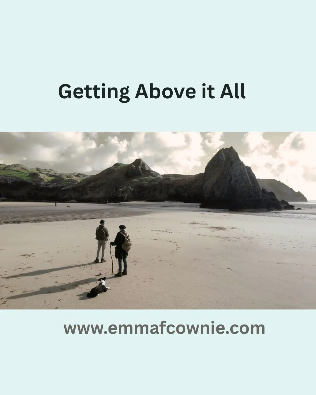
Until last week’s six days of glorious sunshine, it has rained almost constantly here. This has kept us indoors, reluctantly, and unable to enjoy the Gower Coast, or able to look for inspiration for subject matter for paintings. It has been a pretty depressing to be honest. So with last week’s sun, we spent nearly every day re-aquainting ourselves with this wonderful landscape. By we, I mean my husband, myself and our dog, Effie the collie, who absolutely loved running herself into the ground, or sand, in the beautiful beaches of Three Cliffs Bay, Tor Bay, Mewslade Bay and Rhossili Bay. My husband, Seamus, also managed to fit in the Knave, a gorgeous area between Mewslade and Port Eynon.

The Knave

I have been using my Canon camera but my husband has also been experimenting with compositions photographed by drone. We have (had – one was lost near Mewslade) two DJI Mini 2 drones which are fairly basic compared to some but which are quality enough to take drone photography good enough to paint from, which is really the whole point.

We initially used drone photography partly as a response to living in Ireland, especially the Republic of Ireland, where some beautiful landscape was sometimes inaccessible or on private land so we would have fly above it to get a good view of it.

We also found that the drone did not have to be that high off the ground to be produce interesting shots. Compositions seemed to improve from only 10  or  20 foot in the air. We rarely go too far above the landscape feature we are trying to photograph.

Coming back to Swansea and intending to repaint “old ground”, so to speak, it is important for me to keep things fresh, otherwise my work can become laboured or even slightly bored painting the same subject matter in the same way as before. So drone photography helps freshen up the process. It also helps one to re-imagine compositions in terms of landscape painting.

It has helped me see composition in a new way and it has also helped us to become more aware of how various bits of Gower landscape “fit ” together. 

There are no longer isolated, and seemingly unconnected, areas anymore.

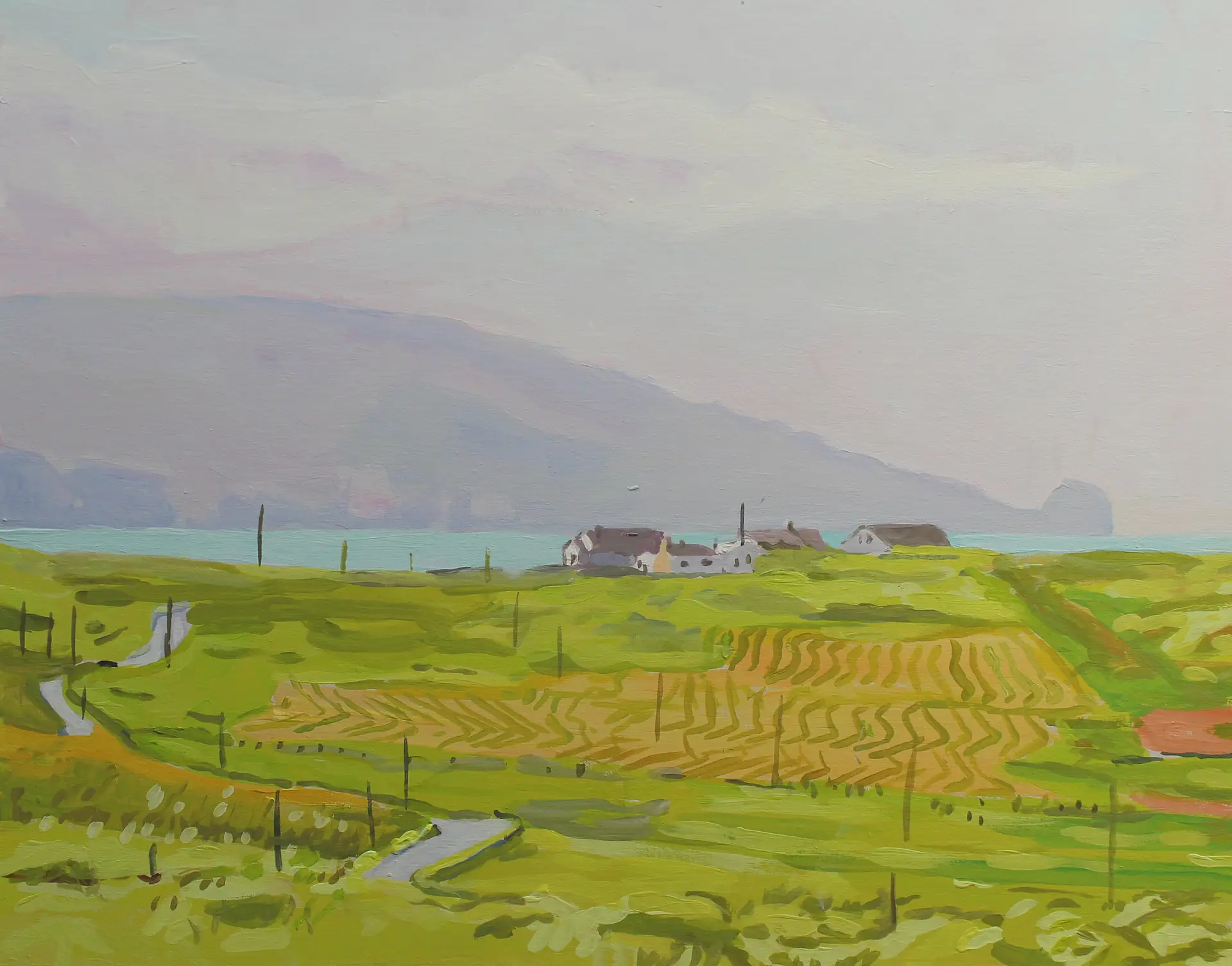
For example, the photo above shows the Worms Head area with Fall and Mewslade bays behind and the Knave beyond that.  The various areas of landscape now form a more coherent whole. I will give some examples below of the images we have been capturing down in Three Cliffs Bay and Tor Bay and how they have resulted in a couple of paintings.

Three Cliffs 

Droning is also good fun, flying around the countryside having a bird’s eye view of the landscape is strangely liberating and, at times, exhilarating – so says Seamus (I find it quite alarming at times, I dont have his nerves of steel).

Effie, our dog, had her first excursion down Three Cliffs  which saw us walk down the rocky paths and great sandy swathes from Penmaen car park to Three Cliffs Bay. 

How great it was to see those monumental stacks again, like seeing an old friend, rising impossibly from the sandy ground. Effie was pretty good with the other dogs on the beach who were trying to join in with her ball chasing fun.  Fortunately she is ball-chasing obsessed and as long as she has a job to do, some work, she is fairly singleminded and behaves well.

This was a relief, as we were worried it might take some adjustment for her as her previous experience of beaches were 2-mile empty beaches in Inishowen and in West Donegal where she rarely came across other dogs. Also, Donegal people are often so polite that they leave the beach when you arrive and let you have free run of it to yourself. It is great having a beach to yourself, a real treat and luxury!

Great Tor, Gower
Effie at Three Cliffs, Gower
Effie at Three Cliffs, Gower (I have the ball)


In Gower, even in early Spring, there are numerous other dogs to contend with, but most are just out having a great time like Effie, so are generally not much trouble. It has been great seeing Effie have so much fun, she loves running on the beach.

Effie on Rhossili Beach with Worms Head behind
Effie on Rhossili Beach with Worms Head behind (again I have the ball and her attention!)


My husband droned Three Cliffs the week before when the tide was in. It was out when we were there.

Three Cliffs, Gower


My first drone photography inspired paintings were both of Great Tor and I am presently working on my first Three Cliffs paintings since I have returned. 

I have been working on commissions in the last few weeks. 

Great Tor at Low Tide #1

Great Tor at Low Tide #1 by Emma Cownie


I found this a very dramatic composition which conveyed movement and vibrancy. The light is still Winterish and bracing.  

Great Tor at Low Tide #2

Great Tor at Low Tide #2 by Emma Cownie


Although this is of the same Tor it looks very different. Drone photography allows you to explore different aspects of the same subject matter. It allows you to see things differently from different heights and angles. Much like a person’s face can appear different from different profiles. This keeps the creative juices flowing as it is possible to re-imagine similiar subject matter in so many more ways.

Plus all these aspects can combine with photographying at different times of the year with different light. For example as the days draw longer, it will be possible to drone on the other side of Great Tor, a side usually in dark shade at present. Longer Summer days will provide new aspects and new compositions. 

The possibilties for composition are greatly increased with droning. For example, the colours in this second painting seem warmer as the drone is lower and reflects the sandy orange rather than in Great Tor #1 where the drone is higher and is reflecting the sky and the painting is more  imbued with blue-tinged light. It took a while to realise how the height of the drone greatly influences colour. This is an area which I find very interesting. With a camera, light and colour is relatively more stable and predictable. With a drone so many more variables around light, colour and composition come into play. 

So that is it for now. I will blog again soon and hope to blog more frequently in future. 

The next blog will highlight some of my recent price reductions on some work which are now in place on this website,  if you wish to browse my galleries, while we wait for another succession of sunny days to happen again, anyway!


See more paintings of Gower here 


Posted on Leave a comment

My Sale Extended and Woodland birds in Donegal

Emma Cownie Art Sale until 10th Jan 2026

Sale extended until 10th January

Just to let you know that I have extended my winter sale to 10th January – Join my mailing list and and get a code which allows 30% off the listed price! What a great way to start 2026!!

https://emmafcownie.com/contact…/mailing-list-emma-cownie/


Recent Sales

Worms Head (Rhossili) on Gower Peninsula by Emma Cownie
Clouds over Bannau Brycheinion (Brecon Beacons)
Summer in Mid Wales
Summer in Mid Wales
Painting of a cottage at Midsummer at Malin Head, Donegal- Emma Cownie
Midsummer at Malin Head, Donegal- Emma Cownie
Marsh at Pennard Pill (Three Cliffs Bay, Gower) painting by Emma Cownie
Painting of fishing boat at Port Donegal
Fishing Boat at Port Donegal-Emma Cownie
Lighting the way to Arranmore
John's Cottage, Malin Head, Donegal_Emma Cownie
Painting of Pen Y Fan from Usk Valley
Pen Y Fan from Usk Valley (Bannau Brycheiniog)
Tenby Terraces - painting by Emma Cownie
Stooknanillar, Inishowen (Donegal)-Emma Cownie

Wild Birds Video

It was freezing cold but the birds were very busy. There is a sign near by asking people not to feed the birds but the locals take no notice (note the bird feeder). I am glad because I loved watching the birds, especially the tiny coaltits. My camera work isn’t much good but at least you know its real and AI generated slop.

Bird on wing mirror
Bird on wing mirror
Posted on Leave a comment

End of Year Sale

End of Year Sale - Emma Cownie Art

Limited Time Sale

We are having an end of year sale. We are offering 30% off all paintings on my website until 5th January 2025.

If you sign up to my website here I will send you a code which you can use at the checkout to get the discount.

Above Waterfoot Beach (Antrim) by Emma Cownie
Termon House, Maghery
Painting of Portnoo, Donegal by Emma Cownie
Portnoo Colours (Donegal) by Emma Cownie
Above the Knave, Gower, Gower
Above the Knave, Gower, by Emma Cownie
From Middle Head to the Lighthouse (Mumbles)
Posted on 4 Comments

Country Road, Winter Sun (Inishowen, Donegal)

Country Road, Winter Sun (Inishowen, Donegal) by Emma Cownie

Today is the shortest day of the year. Its very dark up north here. The morning are very dark yet I find it hard to sleep. When the sun appears it illuminates and reveals a verdent but slummering landscape. I am always looking for flashes of red to paint in the deepest winter. In the past it might be a coat, or a door. Today it is a red roof on an old stone cottage. The old houses are disappearing fast here.

This part of Inishowen near Dunaff feels remote. Maybe that’s because we drove through up and through the Urris Hills and Mamore gap to get here. It’s all small long roads like this one. Its tucked away in a north western corner of Inishowen, Malin Head is to the north, close by. I look forward to the days slowing getting longer.

https://emmafcownie.com/product/country-road-winter-sun-inishowen-donegal/
Country Road, Winter Sun (Donegal) by Emma Cownie
Posted on 3 Comments

Patterned Fields, Rossbeg (Donegal)

Patterned Fields, Rossbeg by Emma Cownie

One of the joys of acrylic gouache is that it dries very quickly and is opaque – so it lends itself to this sort of mark making.

Posted on 2 Comments

Dunree Head, Donegal

Dunree Head Donegal

 Dun Fhraoigh in Irish means, “Fort of the Heather” – it has been a fort at Dunree for thousands of years, since the Bronze age (over 4000 years ago). When you see the chunk of rock that the “modern” day fort (well Napoleonic era) for has been built on, you understand why.

Its a big chunk of rock! (photo credit: Emma Cownie)

Photo Credi t: The Artillery Club of Ireland
Aeriel View of Dunree Head (Google Maps)

Its location, on the cliffs of Dunree Head, is great for observing and controlling ships moving up and down the majestic Lough Swilly, one of Ireland’s three glacial fjords.

The English built this sturdy fort on the chunk of rock c. 1812-3 with a draw-bridge! The enemy back then, as readers of Jane Austen will know, was the French forces of Napolean Bonaparte. (The story of Jane Austen’s Donegal nieces is worthy of a BBC/RTE mini-series in its own right; linking Kent, Ramelton and Gweedore). The French had attempted landing in Lough Swilly in 1798 with a force of about 8,000 men, which was repelled at sea. The Royal Navy anchored ships in the Lough. There were a lot of big guns here, nine 24-pounders were in 1817.  There was once a Martello-type in the centre of the old fort but it was demolished c. 1900, as it obstructed the field of fire from the new fort on the summit of Dunree Hill.

Although the Irish Free State was created in 1922 and they followed (and still follow) a policy of political neutrality, the British army did not leave Dunree until 1938. This was because Lough Swilly was a “Treaty Port”, and it remained under British military control for defensive purposes.  During the Second World War, it was under control of the Irish Army and it played an integral role in safeguarding Ireland when a number of anti aircraft guns were added to site. The waters off the coast of Donegal are under threat today from Russia’s so-called “shadow fleet”.

I am not particularly interested in military hardware, although I know plenty of people in the world are. I have not been in the military museum. What did take my interest, however, were the barracks. There were brick buildings but also a lot of decaying iron huts that the gunners had lived in. I am nosy and I enjoy seeing how people lived. Although, frustratingly, most of that has gone. There tiny glimpses; brick chimney stacks, the odd rusting bedstead but not a lot.


Army Barracks – Brick and iron. Photo Credit: James Henry Johnston
Dunree Army Huts: Photo credit James Henry Johnston
Dunree Barrack Huts: Photo credit James Henry Johnston

A little further up (a steep) hill from Fort Dunree and the barrack buildings is Dunree Lighthouse. This a puzzling lighthouse. I am used to lighthouses being built atop of great pillars like the one across the Swilly water at Fanad.

The one at Dunree, however, has no tower. It doesnt need one. The light is at ground level. The “ground” however its up high on the cliff way above the Fort. A lantern attached to a house for the Lighthouse Keeper was built, and the light established on 15th January 1876. The light was a non flashing one with a two wick oil burner. Sadly, for the lighthouse keeper, technology did away with his job in 1927 when this light was replaced in December 1927 with an “unwatched acetylene with a carbide generating plant attached to the station”. The light was later converted to electricity in 1969. It must have been a great place to live. 

Lighthouse at Fort Dunree (Donegal)
Lighthouse at Fort Dunree (Donegal) – View from the east. The litchen covered stone wall is testiment to the clean air of Donegal

The lighthouse keeper’s house has a spectacular view across the Lough. Its built of local rubble stone masonry, this building retains its early form and character. Its visual appeal and expression is enhanced by the retention of much of its original fabric including timber sliding sash windows. Both the house and the lantern were built by McClelland & Co. of Derry. The simple outbuilding and boundary walls are very elegant too.

From the outhouse towards the lighthouse


The views at Dunree are spectacular. Lough Swilly is quite majestic, even on an overcast day.  Perhaps, it’s particularly dramatic on a overcast day with the shifting light and colours. You can walk up Dunree Hill and look over towards the Urris Hills and Dunree Bay (Crummies Bay).

There is a regular bus service from Buncrana, a coffee house, museum and public toilet. It might be a good idea to go before they start work on revamping the place!

See more paintings of Inishowen Peninsula here

Read More

https://www.buildingsofireland.ie/buildings-search/building/40901824/dunree-fort-dunree-donegal

https://www.donegallive.ie/news/inishowen/1589360/decision-on-12-5m-fort-dunree-tourism-project-due-early-next-year.html

https://www.govisitdonegal.com/blog/january-2024/between-waves-and-war

Posted on 9 Comments

Under the Blanket

Under the Blanket by Emma Cownie

Ireland was once covered in a massive sheet of ice. Then about ten thousand years ago it retreated and trees and grasses sprang up to cover the rocky landscape. Today those trees are long gone. Farmers came and cleared them about 6,000 years ago and the continual rains from the Atlantic soaked and washed the soil reducing the mineral content making it more acidic. Plants like sphagham moss helped keep the land wet. So now West Donegal is covered in something called blanket bog. Blanket bog is a type of peatland found in only a few parts of the world with cool, wet and, usually, oceanic climates. It covers 3% of the world but contains a third of all the carbon in the world.

I love the blanket bog – it covers vast areas. It is a seemingly empty landscape. On an overcast day it has an exhilerating bleakness. On a sunny day, it hints at what a prehistoric Ireland might have looked like (plus a few wolves and lots of red deer). There are few, if any, paths through the bogland. If you venture on the land in summer it is springy underfoot. Most of it is drained with ditches along the road and narrow bog roads leading to “nowhere”.

Blanket bog in West Donegal
Blanket bog in West Donegal (from N252 on the way to Doochary)

For generations people who lived on the boglands drained the land then cut and dried the peat, also called turf, to burn. This was cheap fuel to cook and heat their homes. In a land with no oil or coal, the turf was essential. The landscape across west Donegal is marked with the long scars of peat banks. Cutting it is back-breaking work. In the past the surface of the bog was mostly cut away by hand using the traditional turf spade or sleán. Further South mechanised extraction is apparently the norm, using chain cutter, digger, sausage, hopper and milling machines. In Donegal, however, it is still cut by hand.

The Irish government used to burn turf on an industrial scale, enough to fuel a couple of power stations, up until very recently, 2020 in fact. People with “turbary rights” can cut and burn sod peat on their land for their own domestic uses but they are not meant to sell it. However with fuel poverty, older people in particular, will buy it to use it in winter. A load of turf may cost as little as 200 Euros (about 230 US dollars) and can last months.

The government is trying to discourage this not only because of the enviromental costs but also because of the pollution it causes. It smells delicious but its smoky and very bad for the lungs, especially if you have asthma.

There are moves to encourage the rewetting of the bogs. Targets have been set by the EUand a few pilot schemes in Donegal and a lot more in the Midlands, have been rolled out, Cloncrow Bog Natural Heritage Area is a great example of a rewetted raised bog. However, much more funding is needed from the government to encourage widespread adoption and to help the 4% of the population for whom turf is their main source of heating.

Scars of turf banks line the landscape
Turf drying in the summer sun - Westr Donegal
Turf drying in the summer sun – West Donegal
Turf bagged up
Bags of turf and Errigal
Wildlife growing in the bogland
Wildlife is abdundant in Donegal, if you look down.

The boglands are abundant with wildlife and have been an important part of Irish culture. Bogs were seen as liminal zones – watery places often are. They were seen as places of both life and death—fertile ground for spirits, fairies, and supernatural beings. The bog was also believed to be the gateway to the Otherworld, where fairies, spirits, and even the dead could cross between realms. Many bog bodies and ancient artifacts were likely put there as ritual offerings to appease gods or supernatural forces.

If you want to look at some bog bodies this site has some good photos. I wont post them here, I never really got over looking at the poor soul in the British Museum (Lindow Man) who died in a Cheshire bog. I was fascinated by his face but couldn’t help thinking he could never imagine his mortal remains being looked at by all and sundry over 2000 years later.

One of the most famous mythical figures associated with the bog is Fionn Mac Cumhaill (Finn McCool), the legendary warrior of the Fianna. Some stories say that he and his warriors roamed the boglands, using them as a hiding place during battles.

Red Deer near Burtonport, Donegal

Bogs have also inspired wonderful poetry. This is my favourite-

The One

Green, blue, yellow and red –
God is down in the swamps and marshes
Sensational as April and almost incred-
ible the flowering of our catharsis.
A humble scene in a backward place
Where no one important ever looked
The raving flowers looked up in the face
Of the One and the Endless, the Mind that has baulked
The profoundest of mortals. A primrose, a violet,
A violent wild iris – but mostly anonymous performers
Yet an important occasion as the Muse at her toilet
Prepared to inform the local farmers
That beautiful, beautiful, beautiful God
Was breathing His love by a cut-away bog.

+ Patrick Kavanagh (One of Ireland’s most famous poets, from Monaghan, d.1967)

Cronashallog Bogcut (Arranmore) – a commission by Emma Cownie

And finally…Seamus Heaney’s Poem “Digging” In 1995 Seamus was awarded the Nobel Prize for literature.

Read about Seamus Heaney’s Bog Poems

NOTE: I did not use AI to research and/or write this and I did not use it to “improve” it. I would rather my writing was human and imperfect.

Read More about Boglands

https://www.nature.scot/landscapes-and-habitats/habitat-types/mountains-heaths-and-bogs/blanket-bog

https://theinformedfarmer.com/blog/tech-giants-invest-in-irish-bog-restoration–a–3-million-initiative

https://theconversation.com/peatland-folklore-lent-us-will-o-the-wisps-and-jack-o-lanterns-and-can-inspire-climate-action-today-170202

https://talesofforgottenirishhistory.substack.com/p/the-bog-of-allen?utm_medium=web

Posted on 2 Comments

Termon House Maghery

Termon House, Maghery

Termon House is set above a pebble beach at the north end of Maghery Strand on the West Coast of the Rosses area of Donegal. The elegant white house was most likely built by the Marquis Conyngham or by his predecessor, Montgomery in the 1770’s for the land agent, whose duty it was to collect rent from the local tenants on behalf of the absentee landlord. A Jamaican-born man named Ralph Spence Philips, was in occupancy at Termon House in the 1820s.

Termon House from the Air (Irishlandmark.com)

In 1822 the previous years extremely wet weather rotted all the potatoes in the area which resulted in famine. This was happening across Ireland and around a million individuals came to depend upon government aid during this particular crisis. Government agents in Dublin Castle allocated funds for acquisition of foodstuffs in Ireland, to be distributed to the poor at reduced prices or without cost, and to finance local relief works, such as roads, canals and harbours, or other projects deemed of benefit.

It may well have been Philips who initiated the building of the Famine Walls around the property as a means of feeding the local starving population, although he had no tenants of his own. The Public Works Committee in Dublin Castle, however, rejected Philips application for reimbursement and this meant a personal loss to him of £1500 from paying the labourers at a rate of 1d per day!

Termon House (Dream Ireland image)
The Famine Walls (Go Visit Donegal image)

There is another theory, however, that is that it was the Reverend Valentine Pole Griffith, the Protestant Rector at the height of the Great Famine, 1845-1850, who had the walls built. The Rev Griffith was one of the leading members of the Famine Relief Committee, who worked heroically on behalf of the poor. He set up public works in Maghery, would attend meetings all over the Rosses and write to anyone who he thought could help. The land around Termon House was owned by the Church of Ireland it may well be he who arranged for the massive walls to be built along the road there. On the day we visited it was overcast and my photos do not to justice the scale and extent of the walls.

You can see the famine walls on the right hand side of the house and to the far left side of the outhouses in my painting of Termon House (below). The rocks in the foreground are natural part of the rocky Rosses landscape.

What is undisputed is that this extraordinary and extensive system of walls standing approximately three metres high (10 foot)! The extensive system of tall walls built during this famine around his land is a testament to these hungry builders as they have withstood over 190 years of Atlantic storms.

Today, beautiful Termon House is leased by the Irish Landmark Trust and is available for holiday rental.

More Information

Go Visit Donegal on Facebook

www. maghery.ie/history

Irishlandmark.com

See my paintings of West Donegal here

See My Termon House Maghery Painting here

Posted on 10 Comments

A new book cover – “Saoirse”

SAOIRSE by @charleen_hurtubise

“Announcing SAOIRSE by @charleen_hurtubise, a powerful novel set between the United States and Ireland about a woman who runs from her traumatic past and the secrets she carries to survive. Coming February 24, 2026.⁣”

⁣With artwork by me!

SAOIRSE by @charleen_hurtubise

From Ferry Coll - a painting by Emma Cownie
From Ferry Coll – a painting by Emma Cownie (SOLD)

See more original paintings of Donegal here

Posted on Leave a comment

Cruit Lower, Kincasslagh

Cruit Lower, Kincasslagh

Summer in Donegal is full of light. Even if its damp summer there is still lots of light. The northly latitude sees to that. It only seems to get properly dark for a couple of hours after midnight and dawn comes impossibly soon. So its great for painting and getting out and about but the light is not so interesting for photography or sketching, especially if, like me, you like lots of strong shadows. So my paintings are usually based on images that are captured in the autumn months. Otherwise, mornings and evening are best for interesting colours and shadows.

Autumn Light on Cruit Island, Donegal _ E,mma Cownie
Autumn Light on Cruit Island, Donegal _ Emma Cownie SOLD

Cruit Island is one of my favourite places in Donegal. It’s rocky and sparsely populated but is accessible by a handy bridge.

Donegal Cottages, Cruit Island _Emma Cownie
Donegal Cottages, Cruit Island _Emma Cownie SOLD
Over Cruit Island by Emma Cownie SOLD

We have driven past the collection of farm buildings at Cruit Lower many times but I only managed to capture an image I liked enough to paint this spring. It was an uncharacteristically warm and sunny run of days this May.

The farm has long fascinated me as you have to drive through it. These through roads through farms are not unusal in rural areas in Ireland (and Wales). Informal tracks through a collection of farm buildings, now divided by tarmac.

Lower Cruit was for sale last year and I had a good look at it online. It was interesting as you can only glimpse some of the buildings from the road. I cant remember how much the asking price was. Getting on for a million Euro, maybe. Way out the reach of a poor artist! You got a lot for that; a collection of beautiful historic buildings (some pre-famine era) and access to a beautiful beach and some really incredible views of the West of Donegal. Here are some of the photos from the website. I dont know who bought it but I really hope they look after the beautiful old buildings.

Cruit Lower From the Air
Cruit Lower with Beach behind
Prefamine house at Cruit Lower
Cruit Lower – the view you cant see from the road!

More information about Cruit Lower

https://www.buildingsofireland.ie/buildings-search/building/40904015/cruit-lower-co-donegal

1901 census information http://donegalgenealogy.com/1901cruitlowr.htm

Kinclasslagh wikipedia

https://www.donegalcottageholidays.com/cruitisland-cruitisland

https://www.booking.com/city/ie/kincaslough.en-gb.html