Termon House is set above a pebble beach at the north end of Maghery Strand on the West Coast of the Rosses area of Donegal. The elegant white house was most likely built by the Marquis Conyngham or by his predecessor, Montgomery in the 1770’s for the land agent, whose duty it was to collect rent from the local tenants on behalf of the absentee landlord. A Jamaican-born man named Ralph Spence Philips, was in occupancy at Termon House in the 1820s.
Termon House from the Air (Irishlandmark.com)
In 1822 the previous years extremely wet weather rotted all the potatoes in the area which resulted in famine. This was happening across Ireland and around a million individuals came to depend upon government aid during this particular crisis. Government agents in Dublin Castle allocated funds for acquisition of foodstuffs in Ireland, to be distributed to the poor at reduced prices or without cost, and to finance local relief works, such as roads, canals and harbours, or other projects deemed of benefit.
It may well have been Philips who initiated the building of the Famine Walls around the property as a means of feeding the local starving population, although he had no tenants of his own. The Public Works Committee in Dublin Castle, however, rejected Philips application for reimbursement and this meant a personal loss to him of £1500 from paying the labourers at a rate of 1d per day!
Termon House (Dream Ireland image)
The Famine Walls (Go Visit Donegal image)
There is another theory, however, that is that it was the Reverend Valentine Pole Griffith, the Protestant Rector at the height of the Great Famine, 1845-1850, who had the walls built. The Rev Griffith was one of the leading members of the Famine Relief Committee, who worked heroically on behalf of the poor. He set up public works in Maghery, would attend meetings all over the Rosses and write to anyone who he thought could help. The land around Termon House was owned by the Church of Ireland it may well be he who arranged for the massive walls to be built along the road there. On the day we visited it was overcast and my photos do not to justice the scale and extent of the walls.
You can see the famine walls on the right hand side of the house and to the far left side of the outhouses in my painting of Termon House (below). The rocks in the foreground are natural part of the rocky Rosses landscape.
What is undisputed is that this extraordinary and extensive system of walls standing approximately three metres high (10 foot)! The extensive system of tall walls built during this famine around his land is a testament to these hungry builders as they have withstood over 190 years of Atlantic storms.
Today, beautiful Termon House is leased by the Irish Landmark Trust and is available for holiday rental.
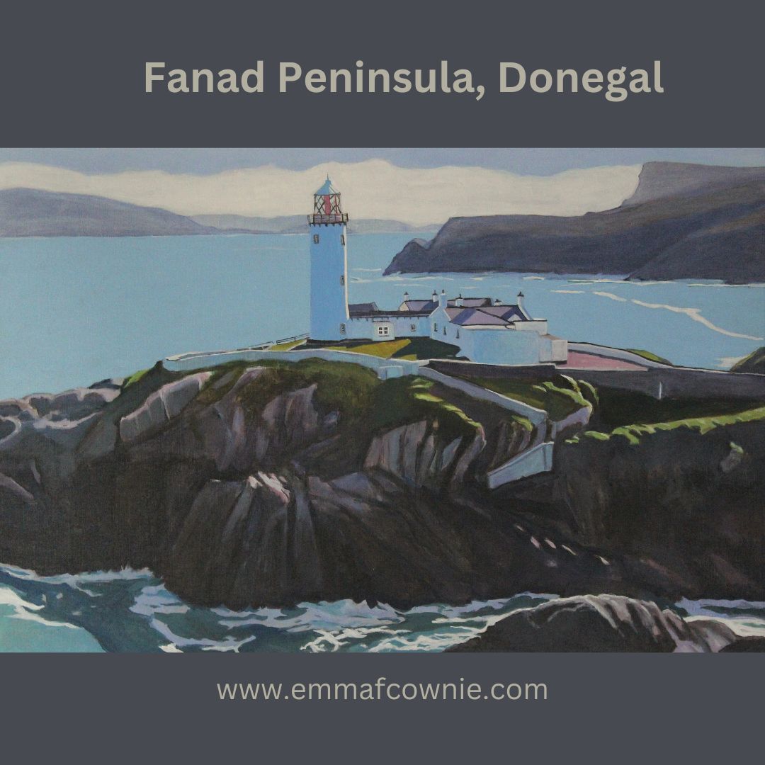
Fanad is a finger of land that lies between Lough Swilly and Mulroy Bay on the north coast of County Donegal, Ireland. It is not that easy to get to and the the survival of the Irish language is testiment that relative isolation.
Lambing season at Fanad Head (Donegal) SOLD
Fanad Lighhouse (Donegal). Is one of the 12 Great lighthouses of Ireland. It was built in 1886 at Fanad Head (although the station was originally established in 1817). The lighthouse, or more acrrately, the harbour light, marks the entrance into Lough Swilly which forms a natural harbour.
Fanad Lighthouse (Donegal) SOLD
I have painted this isolated structure several times before. I have always enjoyed painting the northernly light on Fanad. I have only have painted it in acrylics. That’s not a delibertae choice, more one of circumstance because at times I have had limited space, and I dont want to use oil paints with kittens close at hand.
Over to Fanad Lighthouse (Donegal) _Emma Cownie SOLD
I think acrylics suit the airiness of the subject matter. After a couple of years working out how to use them, I have settled on a technique of light layers of paint that allow the underlying colour to show through. This can give a transulent quality to the colour. This is in contrast to the relatively flat areas of colous I use for the larger areas of colour such as sky or the sea.
My latest painting was an experiment in composition. We used an image from a drone shot done by my artist husband, Seamas (James Henry Johnson).
In this piece, I wanted to create a sense of space from the mountains of the Inishowen Peninsula in the distance. The distant mountains were layered with bluish white until I got the right impression of distance.
I often find myself looking at the tiny Fanad lighthouse far off in the distance when I am at Lisfannon on the Inishowen Penisula. There is a sign comemorating a famous Atlantic storm that happened in 1748. this storm threatened to sink The Greyhound, the ship of one John Newton, a slave trader. John was so frightened that he called out to God for mercy. This moment marked a profound spiritual conversion, and many years later he wrote the words for the hymn “Amazing Grace” one of my favourite hymns, and to also campaign for the abolition of slavery.
There is some confusion how many storms there were . One website claims the terrible tempset happened far away out in the Atlantic because it took John Newton another four weeks after his conversion to sail into Lough Swilly and arrive at Derry/Londonderry. The Amazing Grace.ie site however, makes it clear a second storm happened in Lough swilly itself as it quotes John’s journal ” We saw the island of Tory and the next day anchored in Lough Swilly in Ireland. This was the 8th day of April, just four weeks after the damage we sustained from the sea. When we came into this port, our very last victuals was boiling in the pot; and before we had been there two hours, the wind began to blow with great violence. If we had continued at sea that night in our shattered condition, we must have gone to the bottom. About this time I began to know that there is a God that hears and answers prayer.” It’s got to be said, that John Newton really took his time putting his evangelical beliefs into action because he went back to being a slave trader for another five years before he eventually retired and became a minister in 1757!
The heaving sea at the foot of the massive lighthouse rock intrigued me. The Atlantic Ocean has such a bulk and stregth, even on a relatively fine day, I am not surprised that John Newton was terrified by its strength far away from the Donegal coast. I wondered about the long and difficult process of building this structure all those years ago in a remote location. Yet, this lighthouse has stood the test of time and proudly marks the entrance to Lough Swilly and can be seen from inland and further along the coast.
My work recently has undergone two small but important shifts in focus.
The first is a compositional one.
I have decided to revisit some of the “rules” I first used in 2017 when painting my Welsh “Urban Minimal” paintings (see my paintings for my exhibition in the Cardiff MadeinRoath festival here).
My “rules” for composition and painting this project were:- no cars, no people, bright light. There must be shadows – at diagonals if possible and simplified forms – there must be as little detail as possible. I want to explore the interplay of the geometry of shadows and man-made structures – the tension between the 3D buildings and the 2D shadows. Simplified blocks of colour.
A Selection of my “Urban Minimal” Paintings
I later extended these “rules” to painting the villages of Gower, labelling them (half jokingly) “Rural Miminal” (read more here).
Lately, I have been reflecting on my recent body of work and have realised that many of these ideas got lost in the heady excitment of exploring the new landscape (and skies) of Donegal. Also much of my energy got diverted into recovering from my operation and subsequent recovery after I broke my leg/ankle. I spent several months painting watercolours in my bedroom (as I could not reach my oil paints in the attic)and that led me to think more about composition and simplifying forms.
Watercolour of houses on Gola Island
When I finally made it back to my easel, I could only manage short bursts of paintings so I focused on smaller pieces. The clear blue skies outside my window in Wales may well have influenced my fascination with the weather back in Donegal. Note that my use of colour has changed, they have softened, become more subtle. That’s because both the light and the landscape in Donegal is quite different to Wales. It’s also because I was observing more carefully.
Clouds of Donegal
This brings me on to my second shift. Colour. I was always aware that I played around with colour, brightened them just a little, to create cheerful and vibrant works. For many years I painted cheerful paintings when I, myself, was anything but.
Bright and Cheery!
Painting saved my sanity after a breakdown and going back to a teaching job that I found stressful. The bright colours were a bit of an emotional crutch, perhaps? I am not sure. They may have also been a result of hastiness/laziness, over-confidence with a dash of insecurity.
My Colour Wheel
But change has been coming for a while. I was aware that I sometimes struggled with getting the colour of distant mountains correct. Often the problem lay in the fact that some of my colours were too strong and they needed softening.
I read somewhere that distant colours needed not blue or purple added into in them (as I had thought) but it’s complementary colour. That’s the colour’s opposite number on the colour wheel.
I bought a colour wheel to try and perfect those muted tones and watched a few videos on painting about tone and value. They didn’t really hit home with me. My colour wheel did not have brown on it, I noticed. I had to look for another one.
My distant hills improved. I held my paint brush up close to reference image more often before I placed it on the canvas. I used to only do that occassionally. Now I was trying to do it all the time. Work was slower as I thought and carefully considered my colours.
Tormore Island from Rosbeg, Donegal (SOLD)
I saw a video that reinforced this growing fixation with getting colours exactly right. I saw a video on artist Mitchell Johnson’s Instagram Stories feed. I don’t know who made the video, otherwise I would include it here. I watched many times. Why was watching this clip so fascinating? I was getting excited about watching paint dry!
The tutor had three pieces of coloured card and he mixed the same exact shades of paint so that the paint seemingly “vanished” into the card. The cards were an acidic green, greyish blue and bluish grey. The colour combination he mixed were fascinating as he added colours that I thought were not going work and yet in the end they did (often a dab of orange did the trick). I noticed that he was using a small pallette knife to do the mixing. I ordered some palette knives to mix my paint with too. I have found that I can mix a larger quantity of paint. It means that the colour remains consistent.
The tutor made the comment that his students often asked him “Isn’t this close enough? Will this do?”. “No” he said. That sunk home. I knew I was guilty of thinking “This will do”. No more.
So I set to combining these two “shifts” in thought. The return to simplified forms and the focus on naturalistic/realistic colours.
My first effort was a large painting of the townland of Maghery in Donegal. One or two houses in the middle distant were edited out to simplify the composition. We decided to call this “The Polite houses of Maghery” because they have all been built looking away from each other! My husband says he finds this painting very calming.
The Polite Houses of Maghery – Emma Cownie
I then revisited Gola Island to simplify my compositions futher. I had to resist the impulse the darken the shadows; to strengthen the colour of the pale pink sky, to add lots of yellow and bright greens to the grass. I think the result is also calming. It is ever so less frantic and a bit more chilled than my previous paintings of the island. There are still details, in the tiny reflections and pools of light on the doors and sills. You cannot have colour without light.
Traditional Two-storey House, (Gola)
The Dusty Road (Gola), Donegal, Ireland
I suspect that these paintings better reflect my post-broken-leg state of mind. I go every where slowly and carefully (at the pace of a tortoise, according to my husband). I look at the ground to ensure that I do not trip. I gave up drinking coffee and caffeinated tea to reduce my swollen ankle so I am no longer pepped up on caffeine either. I always am mindful of where my feet are. I am now mindful of my colours too! Slowing down has helped me see colours better.
There are still many challenges to be solved. How will I include clouds in my rural miminal paintings? Will this approach work on a overcast day? Those are problems for another day!
Poll na mbadaí (Harbour of the Boats) Arranmore, Ireland.
Here is my latest Donegal painting. I am delighted that it will be going to its new home in California, USA, very soon.
A narrow lane curves down to a shining white cottage and outbuilding and to the right. This is not a public road but a lane to the house, just around the bend. Here it is bathed in glorious winter light. The low sun creates long dark shadows along the lane. The sheep look up, they are not used to strangers (not like the sheep on the Gower that barely give visitors a second glance). On the horizon, you can make out the tiny but distinctive shapes of Muckish and Errigal mountains . You can just make out a line of fence posts that lead down towards the small natural harbour that gives its name to this place: Poll Na Mbadaí or Poolawaddy. The meaning of Poolawaddy (also spelled Pollawaddy) is often disputed. In irish Poll a Mhadaigh, could mean Poll – the harbour, a Mhadaigh – of dogs or Poll na mbadaí, Poll – the harbour, na mbadaí – of the boats. I suspect that the harbour of the boats is more likely, as it is a natural harbour and pier, but I could be wrong. I only have a basic understanding of Irish but I like to try and read it because place names are very descriptive (as they are in Welsh too) and often poetic. A harbour of dogs is just as possible, after all, there are tiny islands nearby named Calf, Duck and Gull Island.
Arranmore Island map
It feels like it has taken me 7 months to get here. The last painting I finished just before I broke my leg in eraly March was also a painting of this area (see below). It has taken me so long to recover my “painting stamina” and gradually paint larger canvases (although some artists would not consider 80×60 cm “large”). I don’t think I will go any larger for now. I feel exhausted after finishing a large painting these days.
View From Poolawaddy (Private collection) painted in early March 2020
I like to understand what it is that I am painting, to get a sense of its history and the people who live/d there. I might call a building an “outhouse” for example but very often that building was once a family home, a newer bigger one having been built next to it. It matters to me to know that. It helps me make sense of a place. I only know only a little about the History of Arranmore, however, so what I have written here has been taken from articles I have found online (I have included links and a list of websites at the end).
Life on the east side of Arranmore Island, where Pollawaddy is located, is marginally easier than on the west side. This is because Cnoc an Iolair, the highest peak on the island (reputedly once home to golden eagles), provides relative shelter from the prevailing westerly Atlantic winds. This side of the island certainly seems more sheltered, gentler.
Poolawaddy, Arranmore, Ireland (from the other side of the bay). Calf Island is to the right of the bay.
After the Protestation plantation in the 17th century, Arranmore Island, Donegal’s largest island, like other large parts of West Donegal, had been given to the English Lord Conyngham. However, when the terrible potato blight leading to the Great Hunger (“an Gorta Mór”, in Irish) spread during in the mid-1840s he declared the island, which he had never set foot on in his life, as unprofitable and sold it to a Protestant man John Stoupe Charley of Finnaghy, Belfast on 29 June 1849. The new landlord came to live on the island, building a “Big House” (now the Glen Hotel) after 1855 just down the road from Poolawaddy. Very near Poolawaddy, RIC police barracks were built, presumbably built around at the same time to protect the landlord’s property. Interestingly, the RIC left the island after about 40 years and there is still no police station on the island (although the Guards do visit on a regular basis).
Ruins of the RIC barracks: Image from thearranmoreferry.com
Landlord Charley decided to clear as many starving tenants off the land, so he demanded them to present the receipts of their rent payments or face eviction. Of course, few if any had been given written receipts, let alone kept them since most of them could not read or write. The choice they were faced with was either the poor house in Glenties or to emigrate to America in a ‘coffin ship’. Many of these subtenants were evicted in 1847 and 1851. Many who made it into the new world settled on ‘Beaver Island’ (Lake Michigan, USA ). The two islands are twinned. The Árainn Mhór & Beaver Island Memorial, built in 2000, and the sign that Beaver Island is 2,750 miles away, is a memorial to this link. Many of the first islanders who emigrated to Beaver Island were from Poolawaddy. Evictions carried on after John Charley’s death in 1879, when his widow Mary and his brother Walter Charley MP were left to manage his lands. The British government even sent a gunboat, “Goshawk” in 1881 to “assist … the serving of ejectment processes on the tenants in the island of Arranmore”!
Poolawaddy Pier, image from thearranmoreferry.com
The Islanders who left for America emigrated permanently, but seasonal emigration was a more common feature of island life, with many young people working as labourers for farmers in the Lagan, a fertile area in northwest Ulster, and also in Scotland as ” tattiehokers” for the summer. Rósie Rua was one such youngster. She was born in 1879 and was reared on Aranmore Island by her mother and her step-father, the Butcher. In adult life, she gained renown as the best traditional singer in Aranmore and wrote a memoir of her life with the help of Padraig Ua Cnaimhsí. Unfortunately, the memoir seems to be out of print, but I could read some sections of it on google.books.
Róise Rua
In her memoir she describes how at aged nine she was hired out to farmers in the Lagan. Her family home was not far from Poolawaddy and she describes catching the boat to Scotland to work as a farmworker or ” tattiehoker” for the summer. She wrote that “the steamer had dropped anchor off Calf Island, and we saw the boats pulling out from the shore with their passengers. In no time at all, we were all down at Pollawaddy ourselves and one of the small boats brought us out. Lily was the name of the steamer.I was amazed at the size of her…just about a hundred passengers in all boarded the Lily at Calf Island.”
Róise Rya’s Home:Image thearranmoreferry.com
Rósie Rua has a singing festival, Féile Róise Rua held in her name on Arranmore. The first was held in 2019. Sadly the pandemic distrupted the 2020 festival. The festival went online on facebook and you can watch some of the performers here. Fingers crossed the next one can go ahead in 2021! I will leave you will a clip of Jerry Early singing “I’ll Go” (5.55 onwards). Just look at the view out of his window!
We are all told to stay local in Wales, until July anyway. I am still recovering from the operation to pin my broken leg so all of my journeys are very short, and very slow, anyway. I have been taking more adventurous journeys of the mind to Donegal, and to the little village of Maghery in particular.
It lies just a stone’s throw (4 miles or about a 10-minute drive) down the road from Dungloe (I regard Dungloe as the center of my universe when I am in Donegal because it has supermarkets like Lidls, Aldis, Supervalu, and The Cope). The Irish name for Maghery Glebe is An Machaire. We know that people lived here over 5000 years ago because they built stone circles, left tombs, a Crannóg, and a stone fort.
Maghery Beach with Arranmore in the distance
We have only ever been to Maghery twice. On both occasions, it was to visit Crohy sea arch. We failed to find the arch, but we did see some very fine sea stacks called Na Bristí on our second visit. We also found found two beautiful beaches, a Napoleonic signal tower, and Second World War look out post and my favouite, and an Éire Sign.
I would like to visit again, but instead, I can only visit online and “in paint”. The drive through the village has inspired my latest series of three paintings. (The first two paintings have gone to collectors in France and the USA). I was drawn to paint the pink and mauve old houses in particular, mixed in with the white stone cottages.
Driving into Maghery SOLDPink House Maghery – SOLD
Through Maghery, Donegal Ireland
Its only now that I realise the mauve house in my 3rd painting is a very similar colour to the early morning sand on the pristine beach nearby.
Maghery Beach, with Maghery village and Napoleonic signal tower
People have been looking out at the Atlantic Ocean and the surrounding land from the hills near Maghery for hundreds of years. They haven’t always been admiring the view, either. During the Napoleonic Wars, a signal tower was built on the headland in the years 1804-6.
Signal Tower at Maghery
This was one of a series of 12 towers built along the Donegal coastline, to watch out for invasion from French forces. We dont have these in Wales, although Wales invaded by a French force in 1797. That’s beacuse it was not built to protect the Irish population from the French, but because the British did not trust the Irish not to welcome the French with open arms. A few years earlier Irishman, Wolfe Tone, had attempted but failed to land a French force near Lough Swilly. The plan had been to throw the British out of Ireland. His landing failed but there was a successful landing of French forces further down the coast in Mayo. A brief declaration of an Irish Republic followed, but the Irish Rebellion ultimately failed, after a series of battles in Wexford culminating, in defeat at Vinegar Hill.
The signal tower is thus a symbol of deep mistrust by the British. This particular tower is well preserved and surrounded by walled farmer’s fields. The men who were garrioned here communicated with neighbouring signal towers by raising and lowering a large rectangular flag, a smaller blue pendant and four black balls in various combinations along a system centred on a tall wooden mast. This must have been very difficult if not impossible in poor weather conditions.
About 200 meters down the road is the Second World War Eire sign. I am not sure why but I was more excited to see this than the tower. Perhaps, because it was tucked away, designed only to be seen from the air. Perhaps also beacuse it is cut into the grass like a prehistoric chalk horse.
Eire 74 sign at Maghery
The letters spell the word Éire, which means “Ireland” in the Irish language. Over 80 of these numbered Éire signs were dotted around the coast of the Republic during the Second World War. I originally thought this was to warn German bombers that they were flying over a neutral country. This was important as neighbouring Northern Ireland, being part of the United Kingdom, was not neutral. I was wrong, the main purpose of these numbered signs was as a navigational aids for the Allied planes.
Although the Republic were offically neutral they were indirectly involved in the war. In the Spring of 1939, expecting another European War, the British Government had asked the Irish Government to set up a Coastguard Service. The Irish Government agreed to build a series of small concrete huts, known as Look Out Posts (or LOPs) along the coast. There is this one at Crohy and there was another on Arranmore Island near by. The letters Eire (without the accent on the “E”) were written in stone nearby to give aircraft an idea of where they were. The stones were painted white. The numbers (74 in the case of Crohy) were added in 1942 after the Americans entered the war in December of 1941. (Thank you to Séan Bonner for this information).
These huts were pre-built in parts and assembled on site by the army (as the Coastguard Service was under the control of the army). The Irish Government agreed to build the huts and set up the service but on condition that they only would supply radios to the huts in the event of a war. Coast watchers worked around the clock in pairs, reporting every activity observed at sea or in the air by telephone.
As the aircraft would have seen it (Photo Credit:Conor Corbet)
Allied aircraft were allowed to fly over the Republic through the “Donegal Corridor” to airbases in County Fermanagh. These airbases were crucial to provide “cover” for the shipping convoys that came across the Atlantic bringing industrial raw materials and food to Britian. Without fear of air attack, German U-boats would operate as ‘wolf packs’, picking off the ships one by one. All flights were meant to take place at “a good height”. If any aircraft crashed, as at least six did, if they could claim they were on a non-combative mission, they would be repatriated. While it was easy for Allied pilots to make that claim, it was not realistic for Luftwaffe pilots to do so, they tended to be interned. Ireland also helped Britain in secret by setting up an armed air/sea rescue trawler called the Robert Hastie at Killybegs, Donegal, to help any shipping casualties and to supply planes that had run out of fuel.
I didn’t realise it at the time but this is just an updated version of the Napoleonic tower. The ruins above the Eire sign is that of a coast watch station. Coast watchers worked around the clock in pairs, reporting every activity observed at sea or in the air by telephone.
Further along the road is Crohy Head. I think techically is Crohy Head, South. Although there is space to park and a sign announcing its presence, you can sense that the local authority are not all wildly keen to promote this attraction in case people fall down the steep field/cliff face trying to get a good look at it.
The Sign for Na Bristí
I am sitting here with my pinned leg resting on a chair, and it’s twitching unhappily at the sight of these photos now. My leg does not like to think about rough terrains right now. I can just about manage a slow walk around my local park these days (it’s going to be a long slow build up to full recovery). We must have been mad! I thought so at the time too. Still, my husband Séamas who climbed down to the beach to take some photos whilst I sat on the hill holding onto some yapping dogs. To my shame, there was an artist with his easel painting en plein air at the top of the field. I wonder if he could hearing me hushing the dogs and telling Seamas to hurry up.
Sadly, the light was, in my opinion, in the “wrong direction” and early morning would be a better time of day to catch the sea stacks. The sea arch, was just out of sight around the corner. I think that I will save up and buy a drone to take photographs from higher up without imperilling any of my (or my husbands’) limbs! Or a boat. Things to dream about from my chair.
Here is a marvelous drone photo of Crohy Head.
Sea Stacks and Sea Arch at Crohy Head (Photo: Gareth Wray)
Finally, I managed to scale the steep steps to my attic studio! One step at a time. Holding on the handrails.
Ah, what pleasure it was to be back in the attic. It has a view out the back of the house. It is a great pleasure to look at the wooded parks and hills of West Swansea instead of the unrelenting concrete streets and terrace houses out the front of the house. I have a number of commissions to fulfill but I wanted to “warm up” with some small paintings first as I have been working with watercolours for the past two months. Here’s a selection:-
Table Mountain (Crug Hywel)
My first reaction to oil paint was how slow it all is in comparison with watercolours. With watercolours, most of the effort goes into planning and preparation and then the execution of the painting itself is quick. Putting oil paint on the canvas was more laborious that watercolours. I also had to rummage around for looking for the right sort of paintbrushes, a few times. I could not quite lay my hands on what I needed. But, ah! The paint did what I thought it was going to do. What joy! If I changed my mind about a composition or decided that something did not work I could wipe it off the canvas. It did not reproach me for making a mistake by showing it to the world for ever! Nice!
Anyway, I sat down and started a series of new Donegal paintings. Here they are.
Wee House on Gola, Donegal (SOLD)
Storm Over Inshbofin, Ireland (SOLD)
The Two Tin-Roofed Sheds, Arranmore, Ireland
Blue Door, Gola (SOLD)
The Old Stone Shed Arranmore Ireland
These paintings are from the past few weeks. I have also worked on two commissions. It has been slow work at times as I often need a lunchtime nap to keep my energy levels up. I do my rehab exercises several times a day which can be very tiring. On a positive note, I finally got to speak to a physiotherapist, Josh, who has been very helpful. He has posted exercises to me and giving me guidance on how much to do. I can walk upstairs reasonably well, but downstairs one step at a time. When I get tired my ankle gets sore and I limp. I try and avoid that if I can.
What did I learn from watercolours? That I can and should edit and play around with compositions more. I simplified my images as much as I could. I changed the skies or left out an inconvenient house. I found this freeing and I brought an element of this to my oil paintings. For some reason, I have felt to need to be truthful to the real-life locations I painted. I realise now that I don’t have to. I can happily leave out a telegraph pole or a lamp post if it confuses the composition.
Wren
Watercolour painting of robin
What do I miss about watercolours? The tidiness. Clean clothes and hands. The lack of chaos. The speed. The brushes that don’t wear out by the time you have finished a large painting. The lightness. They convey the lightness of birds better than oil colours. Also the convenience, I could pack away all my paper, paints, and brushes in one big bag. I am looking forward to using them outside when I can walk much longer distances!
A while back I came across a quote on the internet that has stuck in my mind:- “If I knew the world was to end tomorrow, I would still plant an apple tree today.” I was quite struck by this sentiment, especially in the light of current events.
I could not remember who said it. So I did some research. I was intrigued by what I discovered online. I found a number of statements:-
It was originally said by Martin Luther, a 16th century German monk
It was originally said by Martin Luther King Jnr, the 20th century African-American Civil Rights Campaigner.
It wasn’t said by 1) or 2)!
This puts me in mind of one of my favourite internet memes by that teller-of-truth Abe Lincoln…
Just joking!
The apple seed quote apparently originates in Nazi Germany in the 1930s, in the Protestant Confessing Church, which used it to inspire hope and perseverance during its opposition to the Nazi dictatorship.
To be honest, it doesn’t matter who said or when (although there’s a lesson about taking things at face value there) because I like the sentiment. No matter how dreadful things seem, they will pass. Eventually.
Here is my apple seed for this week.
The Road by the Loch, Ireland (80x60cm/ 31.5×23.5″)
The Opening night of an “Open” exhibition is an affair full of nervous energy! This is because 90% of people in the room are artists who are all relieved/happy to have their work included in the exhbition in the first place and secondly have come to see where their painting/s have ended up? Are they in a corner? Can they be seen?
Open Exhibition is where the organisers invite or “call” for artists to submit their work (for a small fee). The best works are then selected to be included in the exhibition. There are massive national exhibitions (like the BP Portrait Prize) that are so massive that they have a preliminary round where digital photos are first sent for consideration. The Glynn Vivian, does it the old fashioned way by requiring artists to bring their paintings to gallery for submission. You can submit up to two works each. As, it’s only open to artists living in the Swansea area, it’s not too onerous to drop in the paintings.
All artists fear rejection. We are sensitive souls. So to have to face the prospect of being rejected (one or two paintings) isn’t pleasant. Inclusion isn’t automatic, even if your work has been included before (I was in 2017), especially as the people doing the choosing (or “curating”) change every year. This year’s curators were Richard Billingham and Durre Shahwar. Richard is a photographer and filmer maker who was nominated for the Turner Prize in 2001. Shahwar is a writer, editor, and creative facilitator. Thankfully they chose both of the works I submitted.
I had deliberately decided to arrive an hour into the Opening party as I remember it being very crowded to last time I came in 2017. It was still very crowded at 3pm and the numbers only really thinned out after 4pm. There were 245 pieces in the exhibition. The two rooms in the gallery were filled to the brim with paintings (and artists). were overwhelmingly 2D art. Paintings, sketches and prints, but there were films and sculptures too.
Crowded Glynn Vivian Open
Of course, the first thing I did was try and find my paintings. They were in the second room. I was initially surprised to see that they were not together but had been arranged separately as part of themed groups of colours. I thought that the arrangement worked well. It’s a funny feeling seeing your paintings in amongst lots of other paintings. It’s like a familiar face amongst a crowd of strangers.
There’s no way I can get a photo of both paintings, I thought. Actually, for a long time, I could not get a photo of each painting as the gallery was so crowded.
Spring Light on Gola (top centre)Spring Light on Gola (top centre)
For some reason, people stood in front of my second painting, Autumn in the Rosses for the longest time. Different groups of people too. So I had to wait quite a while to get a photo of it and even then I had a person’s shadow on it!
Spot my painting?Autumn in the Rosses (top left)
It wasn’t just me trying to get a photo of my work. These artists were very excited about being in the exhibition. Their joy was a delight to see.
“Textile Bouquet” by Eleanor Anne Owens
There was so much to look at in the exhibition. There was such a variety of work too. Here are just a few that caught my eye. The most affecting work were the two bird sculptures by Mike Hill. One was made of fishing tackle detritus and the other was in the shape of a cormorant smothered in tar. In fact, the tar-bird was so affecting that I had to fight back the tears. There were quite a few works that touched up the climate emergency and waste but these two, in my opinion, were the most powerful ones.
What are we Doing? What Have We Done? No.1 and No2.What are we Doing? What Have we Done? No.1 and No2.Dafydd Williams “A Coded Reverie”Steve Pleydell “Margot”Amanda Puleston “Doolin, Ireland” – It’s knitted art!
I particularly liked the animal/nature themed wall.
I also really liked Myles Lawrence Mansfield ” Rejections/Acceptance Machine”. I liked it even more when it was explained to me that it moved when you turned to handle! I always like things that do something. Thinking about it now, it may well have been a comment on the life of an artist!
Myles Lawrence Mansfield ” Rejections/ Acceptance Machine”
I had to pleasure of meeting fellow artist Wendy Sheridan in real life (after many online interactions via social media). She very kindly took my photo!
Me at the Glynn Vivian
I would highly recommend visiting the Glynn Vivian to see all the works in the Open Exhibition. It’s on until 23rd February (closed on Mondays) and is free!
I love looking at maps and finding out the names of places. This is particularly true of the islands that litter the coast of West Donegal near the Rosses. I am always asking my husband, what island is that? He’s usually pretty good at knowing the names (I check on a paper map later). In the summer I spotted a house on a tiny slip of an island to the south of Arranmore. Can you see it in this photograph below?
View from Arranmore
Closer. See it now?
Inishkeeragh
I thought it was just one lone house (was that another house at the other end of the island, maybe?). What glorious solitude! What must it be like to stay on that island all with the spray of the sea so close looking at big Arranmore? This is my painting of the island. I was curious about the feint outlines of ruined houses I could see either side of the restored summer house. I wondered about them and their families.
Over to Inishkeeragh (SOLD) Map of Inishkeeragh (Google)
This is Iniskeeragh. Ireland (like Wales) is rich in descriptive place names. They usually describe are named after features of the landscape, such as hills, rocks, valleys, lakes, islands, and harbours. In Irish, its name is “Inis Caorach” which means “Sheep or Ewe Island”. So either sheep were kept on the island (it seems pretty small for that) or its a shape reminded people of a ewe, which might be more likely?
Inishkeeragh (Google)
After some research (online and in books) back home I discovered that the island had at least 12 families living there permanently, it also had a schoolhouse. I find this incredible for such a small, lowing lying island. It’s 650m x 300m (2132ft x 984ft) in size. I tried to work that out in football pitches. It’s the equivalent to 40 football pitches, so maybe its not as tiny as I think. It is very low. It’s no higher than 11 feet above sea level. Yet you can read their names in the 1901 census here. The family names of the farming families are familiar Donegal ones: Gallagher, Boyle, Sweeney, Rodgers, O’Donnell and a sole Bonner, Grace (35) who was listed in the census as a knitter, she was one of only 2 knitters on the island.
Ruins on Inishkeeragh:- Photo credit Roger Curry
These Donegal islands may seem remote to modern eyes, but they played their part in the culture and history of modern Ireland. Gola Island, Gweedore, may well have served as the model for Robert Louis Stevenson’s Treasure Island. Two men from Gola, Patrick McGinley and Charles Duggan, were aboard the Asgard, the yacht that brought arms into Howth in north county Dublin in 1914, in preparation for the Easter Rising of 1916. Tiny Inishkeeargh also had its connection with the wider world. Writer and political activist Peadar O’Donnell (1893-1986) was a for a time teacher’s assistant at the school on the island and he set his second novel, The Islanders, here. Peadar went on to become one of Ireland’s foremost radicals of the 20th-century.
School House:- Photo credit Roger Curry
Life was tough on the island. Roise Rua described her work on the island kelp-making as “tedious and exhausting”. The tenants had to pay rent of £50: £26 for the use of the land and £24 for the use of the seashore – making kelp, picking winkles or shellfish, dulse and the like.” Sadly, like many other Donegal island communities, such as Owey and Gola, the people of Inishkeeragh was forced to relocate to the mainland in the 1950s.
Inishkeeragh Village:- Photo credit Roger Curry
Sea levels played a big part as at least twice in the twentieth century an exceptionally high tide coinciding with a bad gale forced the islands to take refuge in the two houses that had lofts. They apparently spent hours “in terror, fearing the overloaded floors would collapse.” A storm in 1953 washed away the pier and the government of the day would not pay for it to be repaired. This meant that subsequent storms swept through the houses and within 5 years all the families were forced to leave the island.
Inishkeeragh – Photo Credit: Roger Curry
There was a reunion of Inishkeeragh families and their descendants in 2015 on the island. Internationally renowned Country singer, Daniel O’Donnell, was part of the celebrations (his mother was born on nearby, Owey Island).
Daniel O’Donnell and the Inishkeeragh Reunion
You can see the photos of the day on their facebook page here. You can visit the island with Arranmore Charters, be sure to book beforehand.
Addition sources for Inishkeeragh (Inis Caorachin) came from:
The ferry to Tory Island runs all year round. In the summer months (June onwards) there are extra sailings. We had decided to get an early boat as Seamas, my husband said the weather forecast was for sunshine in the morning, cloudy around midday and then sunshine in the afternoon. I think we are learning to take weather forecasts for Donegal with a pinch of salt. Some forecasts for “cloudy” days translate into blue skies with a few clouds, others into a damp drizzle. We were optimistic but when we arrived at Magheroarty Pier it was overcast. Once we had parked in the generously sized car park, we had to hurry to get the boat. Magheroarty Pier is tidal, so sailings have to leave on time, time and tide wait for no man, etc.
Car at Magheroarty (Muckish Mountain in distance)
We were not quite the last people on the boat but all the downstairs seat were full so we stood on the top deck, me leaning against the body of the ship and Seamas found a large metal box to sit on, the dogs sat close to him. We could feel the movement of the boat as soon as the ferry left the shelter of the harbor at Magherorarty and at times we had to hang onto a metal grill that housed a lifeboat ring.
Queen of Aran – Ferry to Tory
Two men who were standing nearby to us were talking to each other in Irish. Tory Island is probably the strongest Irish-speaking area in the country. It sounded a bit like a Scandinavian language at times – a third Irish speaker stood to one side, listening. They each looked very different from each other in appearance, one was very blonde, one was dark-haired and the third had white hair. The dark-haired man had freckles and light eyes. It is a “look” I have seen a lot in Donegal, Seamas says it’s common in County Derry too.
Map of Tory Island
The trip took just under an hour. The motion of the boat made me feel quite ill by the time we reached firm land. I think being on the top deck made me feel the motion of the baot more than if I have been on the lower deck. It took me at least 30 minutes to shake the feeling of a dodgy stomach. Someone, later asked if we had felt ill on the crossing, and laughed when I said I had. It’s not unknown.
One of the tors of Tory Island
Tory Island lies 8 miles off the coast of Donegal. The origin of the name of Tory Island (Oileán Thoraí in Irish), isn’t universally agreed on. Yes, the word Tory may come from from the Middle Irish word tóraidhe; modern Irish tóraí; meaning a robber or bandit. Ever wondered why one of the oldest British political parties, the Conservatives, are also known as the “Tories”? The term was originally a term of abuse and meant “an Irish rebel”. The insult goes back to the era of Oliver Cromwell’s brutal campaign in Ireland when a band of Irish guerilla fighters was known as Tories.
Another explanation for the name, however, is that it may mean the “island of Tors”. The shape of the island from a distance is a tower, and its northern coastline is peppered with massive tors. This seems just as likely. I suspect that people, however, prefer the story of the name meaning Pirate Island instead of the Island of Tors as it’s more exciting. The remote location of the island has meant that the islanders have had (and continue) to rely on their ingenuity and resourcefulness.
An Baile Thiar
They have lived on the margins of the so-called “civilized world” and kept to their own rules and customs, which were not necessarily those of the mainland. Famously they refused had fallen behind with their rents and rates and a British gunboat, HMS Wasp, was sent in 1884 to forcibly collect the arrears and evict the tenants. Luckily for Tory, it hit a reef near the island and sank rapidly (not so good for the 52 who died). The locals put this stroke of fortune to the power of their cursing stone! This event is one of many Donegal stories about the spooky powers of Tory Island. You can read more in the National Folklore Collection UCD Digitization Project.
One custom that marks Tory as different from Ireland is that they have a king. It’s not a hereditary position, rather one chosen by consensus as a leftover from the days of Gaelic chieftains. Patsy Dan was asked to become king by the children of the previous king Padraig Og Rodgers in the 1990s.
King of Tory (from Wikipedia)
He was a talented musician and painter and acted as a very successful ambassador for the island. At a young age, he had befriended English artist Derek Hill, who regularly painted on Tory and he helped set up a gallery on Tory, where island artists sell their work. He was clearly an energetic man, as was known for personally greeting all the visitors to the island as the ferry arrived from the mainland. He apparently made a point of shaking hands with visitors and saying “Welcome to my island.”
Sadly, Patsy Dan Rodger, died last year and now rests in the churchyard. I saw his grave decorated a wooden cross and with stones around it. I did not take a photo because it felt like it would be an intrusion on the island’s grief. The island is without a king for the time being.
The island itself is a strange mix of very old and modern. People have lived here for over 4500 years. There are a few old cars and vans driving back from the harbour after picking up stuff at the pier.
Tory feels a long way from the mainland, although you can see the coast of mainland Donegal when the weather is clear. It is less than 2 miles long and only half a mile wide. My overwhelming first impression (once the cars and vans had driven off) and we had walked out of the tiny West Town (An Baile Thiar) was of birdsong.
Sparrows, larks and other moorland birds just singing their hearts out. The landscape is full of bold little brown birds, pipits and larks. Some of them even come near to you and sing, possibly as a challenge. We walked along a single tracked road eastward towards the other settlement or “clachan” on the island. We passed a Second World War torpedo that had been painted bright red and erected by the side of the road.
Tory Island (mainland Donegal in the distance)
I marveled at the ground on Tory. To the south of the road, it seemed to be a dried bog and the north it was very stony ground, reminding me of a hardcore carpark. How had anyone, let alone over 200 (at one point it rose to 400) islanders managed to eek a living from such a tough terrain? I have looked at the small stony fields in Galway and thought how tough life must have been for the farmers, but this was much worse. The potato was a versatile crop and remarkably the blight that brought the Great Hunger to mainland Donegal, did not reach the island. Of course, the Tory islanders did not live from farming alone, they were also fishermen and brewers of poitin whiskey.
There was a group of German tourists ahead of us (they all seemed to be wearing blue jackets for some reason). They veered off the road to the left towards what looks like a dip in the earth. We followed them, so see what they have gone to look at and discover that is a massive hole with a cave down to the sea. I would not have guessed this was here from the road.
Cave to the sea
We carried on up to the northern edge of the island. What a view! I am not good with heights as the best of times and I felt quite ill looking over the edge. I lay down on the grass to take photos. The reddish cliffs and cream coloured sea stacks were stunning.
Tory Island Sea StackTory Island
We spent a lot of time walking along the cliffs and back again, taking in the views.
North Coast of Tory Island
There were sea birds flying and squawking. Lots of gulls and razorbills and one lone puffin to be seen. The birds of Tory are the highlight of the visit for me.
We then find the weather has closed in on us. We could see the mist and cloud descending on the lighthouse to the west of us, at the other end of the island. I’d foolishly hoped it would stay on that side of the island!
On the island, weather changes from moment to moment. I am reminded of the sign outside Derek Hill‘s house warning that “Winter weather can happen at any time in Donegal”. Yes, it can.
Mainland Donegal has vanished in a cloud of rain. We get increasingly damp, but not quite soaked through. There’s no shelter anywhere. No trees. No bus shelters (what an utterly daft idea, here). We have a lively discussion about the conditions (I keep thinking of that weather forecast of sunshine in the afternoon) and I optimistically suggest that it will pass soon enough. I am encouraged by the fact that the group of German visitors (off in the distance) haven’t given up and are scaling the heights of Ardil Iril, and are looking over the cliff. So we carry on and by the time we reach Port an Duin, which has a small concrete pier, the rain has halted.
Old winding gear at Port an Duin
We sit down on some rocks and eat our sandwiches and crisps. The dogs get some too and a drink of water from their bowl that I am carrying. The weather brightens up considerably as we climb up to the highest part of Tory. This is Dun Bhaloir (Balor’s Fort), which is an early Iron Age Fort, which is covered in piles of massive rocks, which were part of the defenses. Balor apparently was a fearsome cyclops warlord who could kill a man dead with a single glance of his evil eye!
On Dun Bhaloir, Tory
From here we can get a view of the rest of the island snaking off to the west. It has brightened up now and we take off our coats. The dogs are getting hot and panting.
Tory Island From Dun Bhaloir
There’s a discussion about the return time of the ferry as Seamas’s smartphone has died (and I don’t have one). We’d asked about the times when we got off the ferry but after the long walk we aren’t sure of what we were told, was it 2.30 or 3.30? We could see the ferry heading back to the mainland at 1.30 so I reason that it will be at least 2 hours before it returns. However, we would easily be able to see it returning so we would just need to keep an eye out for it. So we started plodding back to An Baile Thiar and the pier. We were all very tired now. So we start the walk back to the harbour in An Baile Thiar.
Bench on ToryHome maintenance on Tory
We made it back to An Che (the pier) and could see the approaching ferry in plenty of time. I got some extra water for the dogs from a tap in the parish hall. This time we got seats on the ferry so I don’t feel queasy on the journey back. The German tourists are also on the ferry.
As we were coming towards Magharoarty harbor, three dolphins surprise us all appearing in the sea alongside the ferry. I saw a flash of strong blue-grey bodies and then the three of them arching in and out the water behind the ferry. All the passengers on the boat were very excited (as was I). These are my first wild Donegal dolphins. I spend a long time looking at my photos afterward, reliving the experience. I wish the photos were better.
Three dolphins from a distanceCloser Up: Donegal Dolphin
I left with an impression that Tory wasn’t like the other Donegal islands. It felt a lot further away from the mainland for a start. Life was (and probably still is) tough here. When the rain covered the island we might as well have been a thousand miles from the mainland. I know that is true of all islands to some extent, but you really felt it here. We visited in summer, I can hardly imagine what it is like in the winter, surrounded by the raging Atlantic Ocean. I didn’t get to speak to anyone, beyond a “hello” but the islanders are very clearly very independent and resilent. Looking over my little guide book to Tory I realise that there was lots more to see on the island, that we didn’t have the time or energy to see, namely the lighthouse on the west end of the island, Derek Hill’s painting hut, the Art Gallery, or the round tower or the curious T-shaped “Tau” Cross.Next time, I visit, I will bring more sandwiches and a hat in case it rains again.


")
")