Summer in Donegal is full of light. Even if its damp summer there is still lots of light. The northly latitude sees to that. It only seems to get properly dark for a couple of hours after midnight and dawn comes impossibly soon. So its great for painting and getting out and about but the light is not so interesting for photography or sketching, especially if, like me, you like lots of strong shadows. So my paintings are usually based on images that are captured in the autumn months. Otherwise, mornings and evening are best for interesting colours and shadows.
Autumn Light on Cruit Island, Donegal _ Emma Cownie SOLD
Cruit Island is one of my favourite places in Donegal. It’s rocky and sparsely populated but is accessible by a handy bridge.
Donegal Cottages, Cruit Island _Emma Cownie SOLD
Over Cruit Island by Emma Cownie SOLD
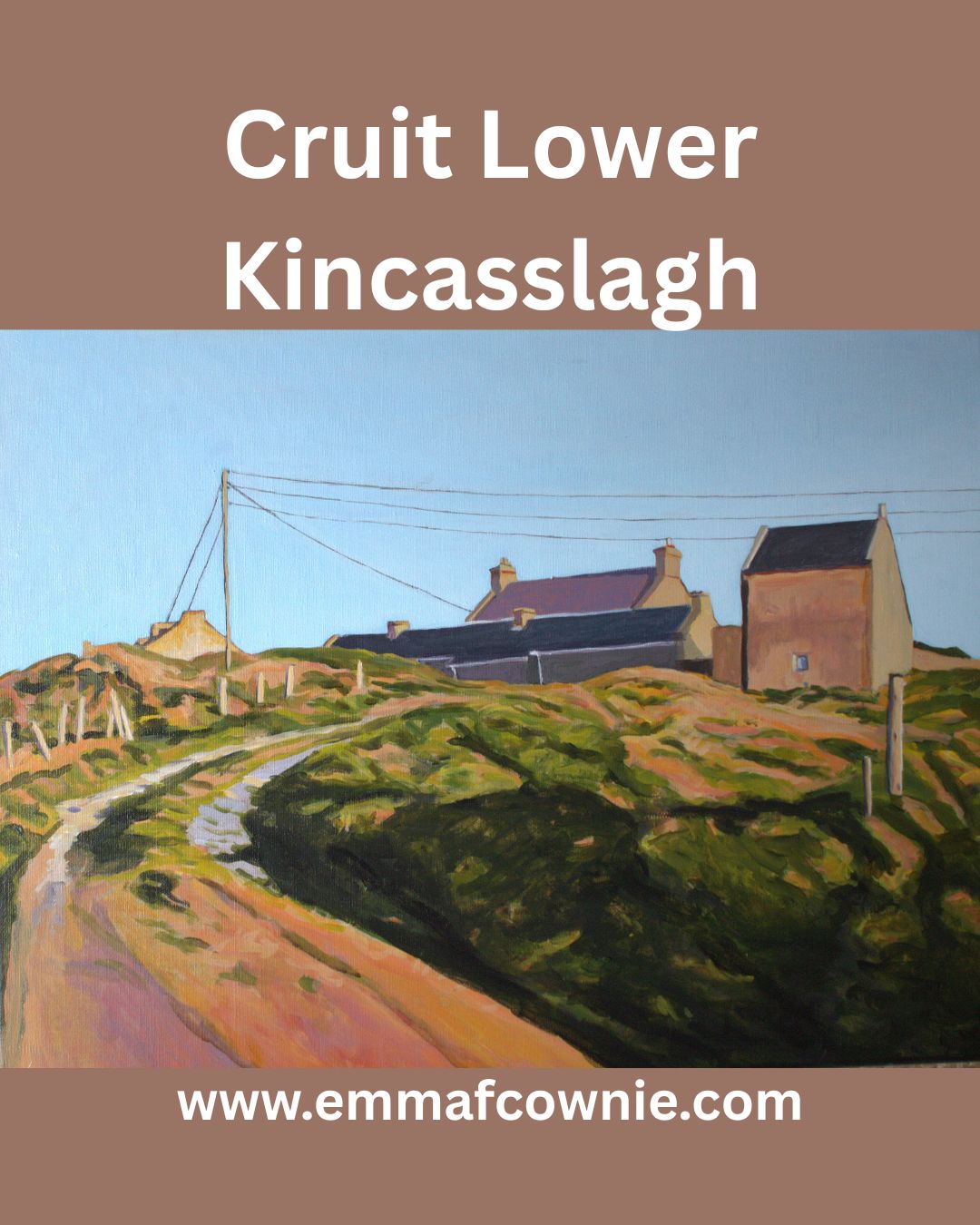
We have driven past the collection of farm buildings at Cruit Lower many times but I only managed to capture an image I liked enough to paint this spring. It was an uncharacteristically warm and sunny run of days this May.
The farm has long fascinated me as you have to drive through it. These through roads through farms are not unusal in rural areas in Ireland (and Wales). Informal tracks through a collection of farm buildings, now divided by tarmac.
Lower Cruit was for sale last year and I had a good look at it online. It was interesting as you can only glimpse some of the buildings from the road. I cant remember how much the asking price was. Getting on for a million Euro, maybe. Way out the reach of a poor artist! You got a lot for that; a collection of beautiful historic buildings (some pre-famine era) and access to a beautiful beach and some really incredible views of the West of Donegal. Here are some of the photos from the website. I dont know who bought it but I really hope they look after the beautiful old buildings.
Cruit Lower From the Air
Cruit Lower with Beach behind
Prefamine house at Cruit Lower
Cruit Lower – the view you cant see from the road!
I have decided that perfect is the enemy of good, and I need to give up on the idea that I should write lengthy blogs posts, as I end up writing nothing! So here goes,
Two grey scale paintings
One of the many great things about being back in West Donegal is that I can paint much larger paintings as my art studio is much bigger here than in Derry. So I now have two on the go!
Donegal Greyscale #1
These are both painted in acrylic paint. I find it easier to make adjustment in the value/tones in acrylic before I move onto a layer of oil as a final layer. Acrylic can act as a foundation layer for oil, but not the other way around. I had forgotten how physically tiring painting a large painting is. My arms are tired!
Donegal Greyscale #2
If you want to know about Greyscaling and why I have adopted this technique since moving to Ireland please see my post “Adventures In Acrylic Paint”
Caravans tucked away on coastal inlets and islands are not an unsual sight in Donegal. I am always impressed by their presence as there are no roads for lorries and it must have taken a good deal of effort and ingenuity to get it there. Getting to have a “Staycation” in 2021 amidst all the uncertainty of vaccine rolls out & third (or is it fourth?) waves looks like it will take an equal amount of effort! So instead join me in imagining the view from the static caravan’s wide window across the rugged terrain of Gola Island on this late spring morning.
When I decided to write this article I was not entirely sure I should. On Easter Monday I was gripped by the unfolding story of a massive, dangerous gorse fire spreading across the Rosses, a part of West Donegal. It worried that it would get completely out of hand and burn down people’s homes and destroy their livelihoods. I was checking twitter and my newsfeed for news of what was happening on an hourly basis to see if the fire had been brought under control. I was also worried about our own house in the Rosses. I love the area very much and feel attached to it. Yet, I felt guilty of being an outsider, what my husband calls a “Sasanach” (Saxon) or a “blow in” to the area only concerned about my house when brave local people were fighting desperately to quell the fires and save their homes. Actually, I was full of admiration for the community spirit and sheer grit and determination of the local people to fight the fire and save each other’s homes.
Donegal is often called the “forgotten county” on account of the belief that it is ignored by the government of Ireland, even in times of crisis. Maybe it’s because it’s so far away from the capital Dublin, or because of its location on the border with “troubled” Northern Ireland. On Monday that perception seemed to be borne out by events.
Over to Kinclassagh SOLD
It had been an unseasonably warm Easter weekend. It was the warmest for 70 years. This followed on from the warmest Irish winter on record, that was also drier than average. Unfortunately, this has dried out the moorlands in many parts of Ireland. In recent weeks there have been many fires over moorland in Ireland and the UK; Limerick, Kerry, Down, and across 700 acres of Yorkshire. Moorlands (and in Ireland the boglands) are “usually” by their very nature wet and soggy places but climate change has changed all that; in these drier conditions, (along with the heather and gorse that grow on them) have become tinder-boxes. Spring and early summer is the most dangerous time of year for gorse fires, between i.e. March and June, when ground vegetation is dead and dry following the winter period.
The Rosses in West Donegal seems particularly vulnerable to gorse fires breaking out. Gorse is a stubborn plant with thick branches, prickly thorns and vibrant yellow flowers during the spring and summer. It is also highly flammable. At least three gorse fires broke out last week; one near Kinclassagh, one near Crolly and another near Drumnacart, Annagry, which actually destroyed two homes.
House destroyed by gorse fire in West Donegal
House destroyed by gorse fire in West Donegal
The gorse fire that broke early in the morning on Easter Morning between Loughanure & Annagry was a different order of scary fire. The dry conditions coupled with the ever-present wind whipped it up and it quickly got out of control and spread over a large area threatened many homes. Fires in windy dry conditions will soon leap and fly. Just to complicate things there was a separate fire at Belcruit/Kinclassagh. It has since been claimed that a fire hydrant, in the village was blocked, preventing fire crews and locals from having a readily available water supply to combat the blaze.
When this fire started 5 fire engines came to try and put it out. By the end of the day, 15 fire engines had come from all over Donegal. One fire engine even came across on the ferry from Arranmore Island. Hundreds of local volunteers also came out to help, many of them were fighting to save their own homes from being destroyed. Trenches were dug, houses were doused with water. It must have been hard, dirty and frightening work. Farmers brought slurry spreaders filled with water to douse the area. Others looked after the people fighting the flames, bringing them bottled water and food.
Dousing the gorse
One fireman told a local newspaper, the Donegal Daily: “This is unreal stuff. I have battled a lot of gorse fires over the years but this is amongst the most dangerous. “Everything is bone dry and there is a strong wind so these are perfect conditions for the fires to spread rapidly.”
Photo credit Brid Sweeney
The local authorities and the Pat “The Cope” Gallager, the TD for Donegal, lost no time in asking (at 9.30am) for The Irish Air Corp for helicopters to help fight the fire. For some reason, they were not forthcoming. The Council waited and waited. Then a group of the firefighters fighting the separate fire near Belcruit were trapped by the flames. The area had been doused by water, so they weren’t in immediate danger, but it was a very worrying plight for them to be in. I can’t imagine what that must have been like to be surrounded by flames, like that.
Donegal County Council decided they could not wait any longer for the Air Corps, and decided to hire a private helicopter to fight the fire. It took 7 hours before the Air Corps finally arrived from Dublin on the scene at 5pm and proceeded to scoop up 42,000 litres of water from the nearby sea and lakes and drop them on the fire. They seemed to have made all the difference.
The Firemen at Belcruit escaped the flames when water was dropped on the fire, clearing a safe path for them. It must be a very difficult job aiming the bucket at the fire but from the video clip here, you can see the Air Corps are very good at it.
I got quite a shock when I saw the photo of Kinclassaagh below on twitter. It is a village I have painted a few times. You may be able to pick out the blue house to the left of the photograph below, which is in the centre of my painting “In the Shadow of Errigal”. The houses in the village are presumably being in doused in water in preparation of the worst-case scenario.
In the Shadow of Errigal
Fortunately, by the evening the fire was eventually brought under control and no new fires have broken out. The images of the aftermath are shocking. So many houses are surrounded by blackened gorse. They were clearly very close to being destroyed. It must have been the stuff of nightmares for the people who lived in them.
The fire will have been devastating for local wildlife and bird populations, their chicks and nests were not saved. This is the sort of event that Birdwatch Ireland calls “carnage in our mountains and hills, yet silence from our Government”. Rare plants whose precious seedlings have just emerged are also scorched along with hares, badgers, lizards, frogs, mice and all sorts of beetles.
The aftermath of the gorse firesThe extent of the fire
When I first heard of these terrible wildfires, I assumed that it was due to climate change and global warming. Yet, when I did a bit of research, I found that it was a bit more complicated than that. Yes, dry winters and summers are factors but it seems that there are other reasons that have contributed to this issue, not only in Ireland but in the British Isles as a whole. So it seemed to me that these issues need to be dealt with more urgently than they have been so far. For all our sakes. Tackling the problem of the gorse fires could actually help with the issue of climate change.
Most gorse fires are started by humans, although we don’t actually know how Monday’s fires were started, and it seems pretty clear that they were not started by a local farmer. In many cases, however, it seems that wildfires are started deliberately by landowners, or by arsonists, or even accidentally by tourists’ barbeques (as in the case of the recent fire in Yorkshire). Northern Irish fire service estimates that in one month in 2017 they dealt with more than 500 fires, of which 466, it believed, were started deliberately.
Gorse is so difficult to clear, its not uncommon for farmers sometimes burn the land so it can be cleared. It is currently against the law in Ireland to burn land from 28 February to 1st September. This is to protect nesting birds and their young. Paradoxically, part of the problem is that these fires don’t happen often enough. Many Irish hill farms have been abandoned or neglected and regular burning has not taken place, allowing layers of detritus to build upon the ground while gorse and heather have grown leggy, meaning that fires are harder to control. Thus, the rise in the number of gorse fires may have more to do changes in farming practices than climate change, as such.
In an ideal world, I believe, upland farmers would not be paid to clear land but instead, be paid to grow native trees on their land. Yes, call me a tree-hugging hippy, but by reintroducing trees, shrubs, birds, insects, and large mammals would have their ancient habitats restored. Ireland needs more trees. The world needs more trees. This is a good way to tackle climate change, instead of cutting down the rain forest at ever increasing rates. More trees also reduce the risk of flooding. A recent study by Bangor University (the one in Wales) found that water was absorbed 67 times faster by native woodland than on grass. Once 80% of Ireland was covered in trees, now it’s only 10.5%; the lowest in Europe (the average is well over 30%). Of that native trees comprise just 2% of the total! These incredibly low numbers are primarily due to human activity in the 18th and 19th centuries, and to a lesser extent also activities in the early 20th century.
The government does plan to increase Ireland’s tiny forest cover to 18 percent by 2046, under the Strategic Plan for the Development of Forestry, but unfortunately, the vast majority of new trees are Sitka spruce tree farms. These are non-native trees, planted in crowded, rows, robbing light from the forest floor. They do not encourage wildlife in the way that native trees would. They are barren places. They also need fertilizers and pesticides. They are patently, the wrong trees. The woodland League recently ran an excellent scheme supported by President Michael D Higgins, called “Forest In A Box”, involving 700 children in nine primary schools in Co Dublin, Co Offaly and Co Clare. The “box” in question is a native tree seed box – a metre square – which can provide up to 200 healthy native trees every two years. It would be great if this scheme could be rolled to the whole of the country, maybe there are plans to do so.
One thing they are not short of in West Donegal is community spirit. On Monday evening, the brave people of West Donegal will come together again, for a massive clean-up operation to collect all the objects like water bottles, spades and face masks that were dropped whilst fighting last week’s fire. Yet again it will be all hands to the pump. It will also be a good opportunity for the brave, hard-working people of Donegal to “debrief” after such a traumatic experience. This fire won’t be forgotten for a long time, but fortunately, no lives were lost.
(Here’slink to a beautiful Irish language series on Irish trees, it’s well worth watching, because it’s atmospheric, poetic and informative. Click the “CC” logo on the bottom right of the screen for English subtitles )
I love painting the coast, particularly if it’s rocky. Owey Island, lies just a short distance off Cruit Island near Kincasslagh in west County Donegal. Strictly speaking there have been no permanent residents since the 1970s. [Photos from http://www.welovedonegal.com/islands-owey.html]
There is no electricity or mains water, yet plenty of people visit and many visit during the summer months. If you want to visit, there is a ferry service run by Dan the Ferryman.
View of Ireland From Owey Island (Ian Miller)
The name Owey, in Irish Gaelic “uaigh”, means cave. The island is a cavers, kayakers and rock climbers’ paradise.
The island is encircled by massive rock stacks and it also has an underground lake. As I am cave-phobic this video is the closest I will ever get to it!
I am fascinated by rock stacks and Donegal has plenty of them. I like to think of how these massive structures have gradually been eroded by wind and waves over thousands of years, forming first sea arches and then stacks.
I also love the colour of the rocks and the wild Atlantic Ocean. The ocean is incredible shades of blues, greens and mauves, mixed in with browns and frothing surf. Although I feel I am getting better at representing the layers of Donegal sky and clouds, but capturing the movement of the seas is still frustrating me.
Over to Owey Island (SOLD)
If you to find out more about Owey Island see Ian Miller’s Unique Ascent’s website for detailed descriptions and incredible videos.
Just thought I’d add a post script about the “Holy Jaysus Wall”. I think if you look at photo of it you will understand the name. It makes me feel ill just looking at it!
Holy Jesus Wall
SONY DSC
Irish climber and alpinist John McCune, climbed it in 2014.
Here’s a fascinating film clip from the 1970s about Owey Island’s postman, Neil McGonagle, who used to visit the dwindling population on Owey Island by small boat four times a week to maintain the island’s contact with the outside world.
I sounds mad, but I didn’t have a map when I was driving around Donegal. I sort of hoped I could buy one in a petrol station but I never did. The Hire Car people lent us a Sat Nav but I could not be bothered to plug it in and it stayed in the boot the whole week.
I am very lackadaisical when it comes to planning holidays, I think all my energy goes into the logistics of getting there. Anyway, I assumed that my husband would tell which places were worth visiting. Afterall, he had spent hours “flying” up and down the roads of Donegal on StreetView. I sort of knew where I wanted to go; Bunbeg, Bloodyforeland, Falcaragh, Dunfanaghy, Derryveagh, Kincasslagh and Dungloe and the distances between them were not very great.
Donegal Islands Map
On the only properly sunny afternoon we had in Donegal, I took a left off the road from Dungloe to Kincasslagh. The sign said “Cruit Island Golf Club”. I reasoned that golf clubs are usually located in beautiful places, near the coast. So I followed a single track road and over a small concrete bridge on to Cruit Island. If you look at the map above, you can see that Cruit Island is long, three miles long, in fact.
Bridge to Cruit Island
Cruit Island at Low Tide
After a pleasant drive along a single track road, and passing what can only be called mansions at the north end of the island, we reached the golf club. Now in the UK golf clubs can be funny about other people coming onto their property, but there was nowhere to turn the car so I kept driving. Eventually we reached the golf club car park which looks out across wild waves to an island. This was no calm inland lough. This was the Wild Atlantic. The wind was fierce and the waves crashed and boomed.
Owey Island, Donegal.
It was mesmerising. The island was just across the turquoise water. It was dotted with houses, some clearly derelict, others in good order. I didn’t know it at the time but this was Owey island.
Quay on Owey Island
It turns out that Owey island is uninhabited for much of the year, having no permanent residents, but people do live there in the summer months. It was last inhabited on a full-time basis in the mid 1970s. The last residents were three old boys who were moved to the mainland of Donegal, or as the islanders call it, Ireland. All the houses were built on the south side of the island, facing Cruit Island Golf Club. The north of the island is too rocky and too exposed to the north Atlantic Ocean gales.
Buildings on Owey Island
My eye was drawn to one building in particular. Standing on the brow of a hill, its missing roof caught my attention. It had also had a walled yard behind it. I was too far away to be able to tell whether this was a derelict old building or an incomplete new one. There are many incomplete “new” buildings littering the Irish landscape.
This turned out to be the old school. The walled yard was the play ground. It was a tiny school with just one teacher who would have to teach all ages of the small number of island children. It was a school for the younger children, and when they were old enough the children would then be sent to the mainland for their secondary school education.
Apparently, the school children had to bring a sod of turf to school each morning. The turf was fuel for the fire and the idea was that they provided the heating for the school room in the cold months. It has been pointed out that as the teacher’s table and chair were at the front of the room, they would usually sit right in front of the fire. When I used to be a teacher, I used to teach in a “temporary” demountable classroom (it had been there for 40 years) and in winter, I would often stand next to the gas fire, myself. So I liked that idea!


")
")
")


")
")


