I have been ill this week so this is a short post.
In last week’s post, Seamas, my husband and I were standing on rocks looking out towards Gola island in Donegal. This week we are looking back inland to Dunmore Strand, and beyond to Mount Errigal.
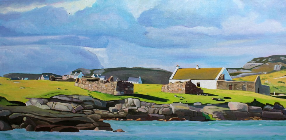
Dunmore Strand (with Mount Errigal in the distance)
As soon as I saw this scene I knew I wanted to paint it. I loved the dark shadow under the protruding lip of the undulating dunes. It gave the impression that the grasses were merely a thick blanket laid across the top of the sand.
Scattered along the beach and in the water, were granite rocks. These were so large that they were more like massive boulders. They were a beautiful pinkish colour close up. The sand was also very slightly pinkish but closer to the shoreline it was almost white. Lines of seaweed marked the rising and falling tide.
The tiny white houses gave a sense of sense scale of the dunes. They reminded me a little of boats on the surface of a heaving sea; humans eeking out an existence on the edge of nature. The ocean itself was calm and benign. It was as clear as glass at the shoreline and further out was a beautiful turquoise. It is not always this smooth creature, in autumn, I have seen it roaring and thrashing the shoreline like a wild beast.
Mount Errigal dominates this part of West Donegal, known as Gweedore. The mountain looks close but it’s an optical illusion, it’s actually about 10 miles away to the east. The top of Mount Errigal was swathed in clouds. The mountain always seems to have clouds around its shoulders, or totally smothering it. I had to wait for about 3/4 of an hour for the mists to part for a clear view of the peak. The clouds near to me were dirtier rain-filled clouds that were building and threatening to release their burden on the land somewhere nearby.
Another wonderful thing about this beautiful beach is that on this chilly April afternoon is that there was not another soul there. The only people we saw were the postman in his van on the way down the long lane to the beach.
My next post will peer “through a glass darkly” at Seamas’s Donegal family history (it is very dark in places) and the History of Gweedore along with the controversial issue of modernizing landlords.
My husband, Seamas, loves islands. He’s not alone, many people dream of living on or even owning their own private island. I just love looking at them and painting them. Which is handy, as the coastline of West Donegal is completely smothered with them. Looking out from the coast of Donegal, one of the longest in the country at more than 800 miles, is a bit like looking at the night sky and trying to name as many of the brightest stars as you can. Seamas seems to know most of their names without having to look at a map.
The larger Islands of the Coast of West Donegal
Around the coastline of the island of Ireland, there are 365 small islands, and a good number of those lie off the coast of Donegal. Wikipedia has individual pages for 20 of them, but there are many more than that. I can’t find an exact number. Many islands near the coast are little more than rocks big enough for some seaweed to cling to the edges of, visible only at low tide. Maybe these are just baby islands, islets. How big does a piece of land surrounded by water have to be to be an island, I wonder? If it’s big enough for some grass and a cow it must definitely be an island. There are quite a lot of those near Burtonport. The cows are well known for swimming between the island in search of better grass. I kid you not, it’s common off the coast of Inishcoo – click here for more evidence. I think the association between cows and island grazing is an ancient one as several islands take their names from cows, such as inishbofin (Inis Bó Finne) means island of the white cow and Calf island near Aran Island.
There are also about 100 sea stacks. Are these thin, vertical towers of rocks jutting out of the sea proper islands, I wonder? Slighter bigger and desolate are The Stags, or Stag Rocks, also known as The Three Sons of O’Gorra (Na Trí Mic Ó gCorra) which lie someway to the north of Owey island. Legend says that they were three pagan swimmers who were turned to stone by St. Colmcille the 6th Century missionary, also known as Columba.
The Stags
Then there are islands that have (or used to have) people living on them. Arranmore is pretty big (8 square miles) and is home to a sizeable community of about 500 people full-time residents. Some islands are easy to get to, such as Cruit, which has road bridge to the mainland, and Arranmore and Tory which have a daily ferry. There are others that have only summer ferry such as Gola and Owey Islands.
There are a lot of islands with no ferry but can be reached relatively easily by boat or kayak such as Inishsirrer, Inishmeane, Edernish, Rutland, Eighter, Inishillintry, Inishinny, and Bo, Go and Allagh, Inishmeane, Inishdooey, Insihbeg, Inishfree Lower but are close-ish to the mainland, and others that are pretty remote, even to people with their own boats such as Umfin, Tororragaun and Raithlin O’Birne and then finally there are the very remote ones are Stags Rocks mentioned above and Roan Inish. Some like Arranmore and Tory are inhabited all year round, others like Owey and Gola are mostly home to people during the summer months.
From Cruit Island
I love the descriptive names of the islands thus Cruit (An Chruit) means harp-shaped, Owey (Uaigh) means cave as there’s one under the island, Island Roy (Oileán Ruaidh) means Red Island, Inisheeney (Inis éanaigh), bird island and Tory Island, (Toraigh) means High Tower and when you see photos of the island you understand why that is a good description of the island.
Tory Island from the mainland
I have driven across the little bridge to long Cruit Island and I have boldly reversed my car onto the ferry to Arranmore and back again. I have spent a fair bit of time standing on the shore looking across the water at islands, Owey is a good example of this.
Owey IslandOver to Owey
My latest subject for this mainland-based island-gazing is Gola. Its name sounds vaguely sporting, forever muddled in my mind with football and trainers probably because I used to have a pair of Gola gazelle trainers back in the 1990s. The island has nothing to do with trainers or goals. The name Gola, or Gabhla in Irish, means “forked”. If you look at a map of the island the name makes sense. The fork is the split in the west face of the island.
Map of Gola Island
We set off on a sparkling afternoon in early April. The sun is out but it’s cold, with a chilly wind. I’d wear my big wooly hat in the car but the bobble on top is too big and it hits the headlining. So I drive without it on. In order to get to a good look at Gola, we drove past Donegal’s tiny airport at Carrickfinn, along a long single track road. There’s a lovely view of Mount Errigal off in the distance.
Errigal from Carrickfinn
The track then rises and winds its way past a series of isolated houses, both and old and modern. The road is a bit threadbare in places, in good condition in others.
We follow the road until we reach a fine modern house overlooking what I’d call a beach, but this sort of long stretch of curving sand is known as a strand in Ireland. I think this is Dunmore Strand (An Tra Bhan). We climb out the car (I leave my window open in my excitement), with hat and gloves on and various cameras slung around our necks and stuffed in jacket pockets. The tide is out so that I don’t realize that the long stretch of dunes reaching to the north of me, is actually part of a tidal island, Inishinny.
Dunmore Strand
The blond sand is strewn with majestic pink granite boulders and rocks. The clear sea is a most beautiful violet and turquoise. I have never seen anything quite like it. We spent a lot of time staring at the water, trying to fix its colour in our memories. The seaweed resting in between cracks in the rocks is a fantastic livid green.
Woolly hat back on, taking photos of Gweedore and Bloody Foreland
Beyond the dunes is in the distance to the east is Gweedore and the village of Bunbeg and Magheraclogher beach. The terrain is peppered with lots of little white houses, most of them modern. In the opposite direction to the east is a very different landscape.
View towards Gola
We have to walk along the sheltered beach and climb across a series of massive rocks to get a better look at the island. The island of Gola seems tantalizingly close, it’s only about half a mile. We can see the ruins of many houses, but also many painted white and with good roofs.
Houses on the south side of Gola Island
Seamas was very excited to see the island, as there is a possibility that his Donegal Coll forebears may have lived on the island. However, although we know his paternal grandmother originally from the Gaeltacht (Irish speaking area) somewhere in Gweedore, we cannot track her down in the records. There are lots of possibilities but no certainties.
Gola, is a small, very rocky and rather exposed-looking island. Mind you, I was looking at it from across the water, and it is consistently described as “beautiful” by visitors. The silvery quality of the light on the white-washed building nearest the shore certainly caught my eye. I tried to convey the quality of the light in my first painting of the island.
Spring Light on Gola (80x40cm)
We then clamber across another set of massive pink granite rocks to the headland nearest the island. It is more exposed here. You can get a better look at the houses. I am fascinated by the ribbon of little white-washed houses that look out towards the mainland. They look they were positioned with the prevailing wind (blocked by the hill to the west of them) and company in mind. There is a larger modern house set back from the old cottages.
I wonder whether that belongs to one of the few full-time residents that live on the island. My second painting of Gola, I think give you a sense of just how rocky the island is. The hills and fields are peppered with boulders, rocks and stone walls. The coastline along the south side of the island is a rampart of geometric rocks. No wonder the little harbour is tucked in on the sheltered eastern side of the island.
Oileán Ghabhla (80x 40cm)SOLD
The island is pretty small. It covers about one square mile (500 acres). Although it seems quite flat in comparison with Aranmore, it is “mildly hilly” on its west side, rising to 238 feet at Cnoc an Choillín and 212 feet at An Mhaol Mhór. These hills provided vital shelter for the houses that stretch along the east side. (Images taken from Google Streetview).
On the other side of the island is as statuesque sea-arch.
Sea Arch, Gola Island, Donegal
Gola was once inhabited by a surprisingly large community of over 200 souls. I looked across at this barren-looking land and wondered how on earth they could grow enough food to survive. Mind you, the land is not as bleak as the tiny fields of west Galway, full of stones. Yet survive they did, thrive even. Vegetables could be grown on the land fertilised with seaweed and turf could be cut from the bog to heat the homes. Many of islanders were fishermen and they would also travel to Scotland for seasonal to work each summer to supplement what they could grow on their small farms. Surprisingly, up until 1920s, the island population continued to grow, but it declined after 1930 and then became deserted in the late 1960s.
Yet, the island was never completely abandoned. Families would come and spend summer months here. Although most of the buildings on the island are derelict, many have been renovated by Gola families as holiday homes. The island now has mains electricity and water supply and a small number of people live on the island all year round.
Being an island the sea sustained island life but it also curtailed it. Bad weather could cut the island off from the mainland, especially in winter. The coast of Donegal frequently faces some very severe weather from the prevailing westerlies and the heaving Atlantic Ocean. Gola was immortalised in the sad lament “Baidin Fheilmidh” (Feilim’s little boat), a song about a Feilim’s bat which sets off for Gola and then Tory but was crushed against Tory island, sinking with poor Feilim in it. There are various versions of this song you can listen online including one by Sinead O’Connor but I think I like this paired back version best, which also has the lyrics in Irish & an English translation here.
There is a ferry service that runs from Bunbeg from June to September. Sabba, the ferryman, also runs facebook page under the name “Gola Ferry Service” and it it is a good idea to check before planning a visit.
We were too early in the year, sadly, to visit by boat. I am pretty sure that Seamas and I will be making a trip to Gola island in July when we are planning to be back in Donegal. We returned home to Burtonport for tea and biscuits to warm up in front of the fire.
It’s a long way to Donegal. About 400 miles. That includes the bit of sea, St George’s channel, that lies in between West Wales and the Republic of Ireland.
It took me 3 days to drive from our house in Swansea, South Wales to our house in Burtonport, Donegal. It took me another 2 and a half days to drive back (I got faster).
I know Google maps says you can do the journey in 12 hours in 3 minutes but that doesn’t take account factors such as ferry crossing times, day-light and human exhaustion and how slowly I drive.
I avoid motorways. I have a phobia of driving on motorways. It was triggered by a panic attack that occurred at night on the motorway bridge between Neath and Swansea many years ago.
I have had hypnotherapy, read countless books but to no avail. So, my top speed is about 60-miles per hour but I tend to cruise at about 50 (depending on the conditions and the speed limit, of course). I took me a while to get to 60 miles per hour.
I usually only drive locally so it took me a while to feel comfortable driving over 60 miles per hours.
I did all the driving, my husband in the passenger seat, taking care of the dogs and navigating our route to Donegal.
We decided to break the journey up and Seamas had booked four separate B&Bs to stay in en route (with our dogs) to ensure that I could cope with the driving. I have been back in the UK a week, have come down with a cold but it was worth every bit of effort.
Driving through a country is a real education; it is quite different from flying. Where you mostly see the insides of airports, although the flight into Donegal’s tiny airport is absolutely stunning and no wonder they been voted most scenic landing in the world for the last two years running.
Ireland is a big country (I expect those from North America & Australia are scoffing at that statement) but it’s not quick to travel across unless you are flying. Correction, it’s relatively easy to get to Dublin but not so easy to get to Donegal. There is no railway line (they were closed in the 1940s), no motorway and the most direct route cuts through Northern Ireland, which is only a problem as the “A” roads in Fermanagh are small, windy and not as quick to drive along as the “N” routes in the Republic of Ireland.
The Republic of Ireland has changed a lot since I first visited it in the early 1990s. The impression you get driving across the South-Western countries and the Midlands is of a, modern, confident, prosperous and fast growing country.
The rolling landscape of Kilkenny reminded me of Monmouthshire on the Welsh borders with England, the Midland counties are full of farms and the roads, whilst busy, are in no way as hectic as British roads.
Crossing into county Donegal and then approaching Donegal town, I felt real excitement at the sight of dramatic mountains looming in the distance.
It felt like seeing Snowdonia or the Highlands of Scotland.
This was a different part of the world. The road behind me and ahead was almost completely empty. This helped a lot, crossing a massive bridge on the “N” road, as I could slow down without annoying other road-users, thus helping with my anxiety.
Outside the cottage in Burtonport
Burtonport is an area of Donegal known as the Rosses.
Along the west side lies the Atlantic Ocean, it’s sometimes merciless and raging, at others it is as smooth as a silk sheet and as clear as glass.
The coastline is full of inlets and tiny islands. Inland the landscape is strewn with loughs with massive granite rocks. It’s like no other landscape I have seen. It has more in common with the Highlands of Scotland (they used to be part of the same continent millions of years ago) than anywhere else in Ireland. It feels different from the South too.
The accents here are very different too as they are Ulster accents. Ulster is the name given to northern-most counties of Ireland. There are nine countries in total, six of which, since 1921, lie in Northern Ireland and three, including Donegal, in the Republic of Ireland. This part of Donegal is in the Gaeltacht, which means that Irish spoken here. It means that many of the signs are in Irish. The roads signs are usually bilingual in all of the Republic of Ireland (we have bilingual road signs in Wales too) but here the signs don’t always have the Anglicized name so if you don’t know that “An Clochan Liath” is the Irish for Dungloe or “Ailt An Chorrain” means Burtonport, you may miss the turning! Thankfully my husband is a student of the Irish language and so he could direct me.
What I particularly love about the Rosses is the little rocky inlets, smothered in seaweed at low tide and turquoise sea at high tide.
Lots of houses and cottages dot the landscape, with many islands having a house (or two) perched on top, with little jetties for returning boats.
Each with its idyllic view and solitude.
Yet, if you want company and good chat Donegal is the place to come. As my husband says, having a good chat is the first order of the day. Everything works around that.
Many an in-depth chat was had about the world with people we met. The issue of Brexit and the border-question was on a lot of people’s minds, businessmen were particularly worried by its implications.
My husband, being Irish, was a lot better at chatting at length than me. His record was a two-hour chat with a man he met on a morning walk.
I am going to leave you with one of the first paintings I have finished since returning to Wales. I have had a lot of social media stuff and commissions to catch up on since returning.
I really enjoyed my break and will regale you with thoughts on life with less internet/tv in another post.
I am winding down the social media for a while because we are leaving the UK to spend some time in our house in Burtonport, Donegal, Ireland. The internet will be available on a very limited basis so I won’t be able to post on here until mid-April. I will be checking my emails but I won’t be posting much, if anything, on Facebook, Twitter & Instagram.
I have mixed feeling about the enforced “break” from social media. On the one hand, I hate the way how it sucks up all your spare time and energy and how FOMO (fear of missing out) has you checking updates. There’s always the fear that if you stop “spinning all the plates” that people will forget about you! However, I am certainly looking forward to reading books, listening to the radio (there’s no TV either) and sketching and painting for fun (not oils but watercolour sketches).
I am very excited/nervous about the whole thing because I am driving there and it’s a long, long way.
Please be aware that any artwork purchased after 25th March will only be shipped after 12th April.


")


