Last Thursday morning Bingo, one of my two cats, collapsed in the front garden under a hedge and we had to take him on the long drive to the vets to end his suffering. It broke my heart. I had had him for over a decade and loved him dearly. Hattie, his cat companion of the last 6 years, misses him too and she has been outside looking for him. That’s even sader. We are keeping her indoors for now.
Bingo
So my concentration hasn’t been great. I have struggled to write anything, although I had almost finished another blog. Every time, I looked at images, trying decide what painting to start next, I am crippled by indecision. So I have been painting instead a series of small studies. Playing with composition, and simplifying images. The idea is to reduce detail to the minimum.
Caravan at Magheraroarty 24x18cm
Inishbofin #2 24x18cm SOLD
I then moved on to slightly larger canvases. The photographs of the paintings don’t quite capture their colour. Unfortunately, they have a blueish cast to them.
Inishbofin #3 30x24cm
Inishbofin #4 30×24 cm
Inishbofin #5 30 x34cm
Inishbofin #6 30x24cm
Inishbofin # 7 (SOLD) 30x24cm
Inishbofin #8 30x24cm
I will continue with these and hopefully I will find it within me to paint some much larger versions. In the meantime, we have a large rescue cat we have named Tadhg (pronunced “Tag”) from Burtonport Animal Rescue, in the office. He is named after a famous Irish rugby player, called Tadhg Furlong, on account of his robust physique.
Human Tadhg, the rugby player
Unfortunately, Hattie hissed at him when she first saw him, so we are introducing them very, very slowly. Swapping scents and feeding them on opposite sides of the same door etc. Tadhg was a stray and hasn’t had much experience of the indoor life, so he’s getting used to things like doors (they move when you rub up against them, you know) and mirrors (there’s a big black and white cat in window thing in the bedroom next door he’s worried about). He also loves carpets and heating. When he wants a break he sits under the chair in the corner of the room. I hope we can successfully integrate Tadhg into our animal family!
I have found that my energy is slowly but steadily returning after my operation on my broken leg in March (although painting light is shrinking with the shortening days). I spent much of the spring and early summer sitting in my chair wishing I could go outside into the fresh air or climb the stairs to my attic studio. I painted watercolours instead, and thought a lot about colour and composition. I learnt to simplify my images and edit them with more ruthlessness than I had done before.
Gola Houses (watercolor)
I have attempted to carry these lessons into the compositions of my oil paintings. I suspect that I need to go further. I am always torn between a desire to accurately convey what is probably a well-known location to local people, and the need to create an effective composition. In otherwords I want to create an engaging painting, regardless of whether a viewer has visited Donegal or not.
Blue Door, Gola (oil on canvas) SOLD
Here’s an example of editing my composition. I used several reference photos for this painting of Bád Eddie (Eddie’s Boat) but you will see that I decide to leave out the all the lamp posts. I felt they made the picture look cluttered. I also left out the the skylights on a couple of the houses for the same reason. I did, however, decide to include a couple of series of fence posts on the right side of the painting as they lead the eye down the hill.
One of the reference photos for Bád Eddie at BunbegBád Eddie, Ireland. (Oil on canvas) SOLD
I have gone further with my editing of the reference image in my most recent painting of Arranmore. This is a painting of a (probably abandoned) white house that I had painted a watercolour of earlier in the year .
The White house, Arranmore, Ireland (watercolour)
A lot of the compositional work is done when composing the reference photograph, but there is often a bit more tinkering to be done to clarify the image further.
The White Bridge, Arranmore, Ireland (100cm x 65cm) (Oil on canvas)
Here you can see that I have again removed most of the telegraph poles, just leaving one further down the road. The fence posts as usual, get to stay. The ones on the right led the eye down the road. The central part of the painting on the right side is too cluttered for my liking too. It’s very confusing for the viewer. I have since discovered that this is because there are too many “tangents“. The word “tangent” usually just indicates that two things are touching, but in art the term describes shapes that touch in a way that is visually annoying or troublesome. This also describes those telegraph poles I removed. It all makes for an image that is easier to “read”.
Tangent Chart – From emptyeasel.com
I also removed a several of the buildings so that there is a clear view over to the tiny island of Inishkeeragh with its solidary summer home. Finally, I also simplied the pair of yellow buildings to the far right. I found the semi-abstract result pleasing and I felt that the lack of detail balanced the detail in mud, rocks and grasses on the near side to the left of the painting. I like to balance detail with areas of flat colour, such as the roof of the house or the sea, as I think that too much detail all over makes the head sore. The human brain doesn’t process images in this way any way. Our eyes/brains will focus on one or two areas and “generalise” other larger areas of colour.
Thus, I hope I have created a succesful painting rather than slavishly copying a photograph.
White Bridge Arranmore, (in situ)
Read more about avoiding confusing tangents in compositions here
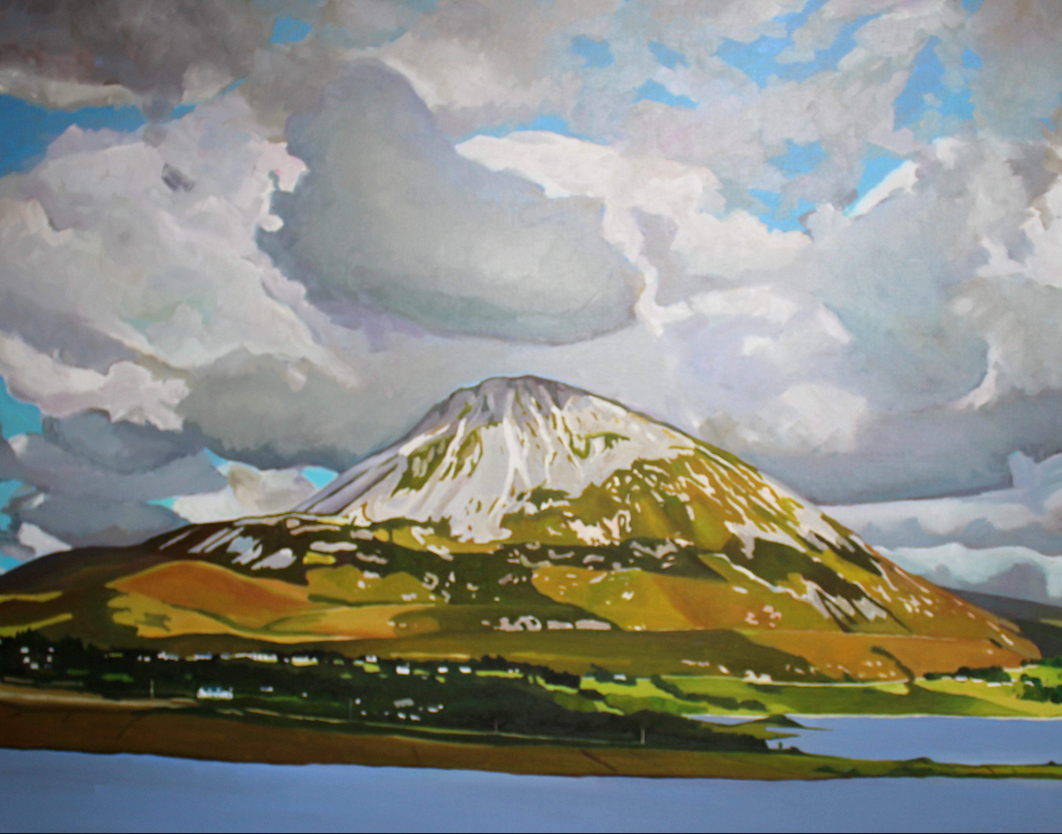
Dunmore Strand (with Mount Errigal in the distance- SOLD
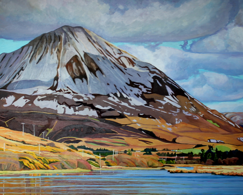
I have written before about how my husband, Seamas, is a bit obsessed by Donegal’s highest peak, Errigal, and how loves to tell me that you can see Errigal from different places such as the beach, the airport, the house, the top of the garden and so on. His father helped run a boxing club named after the Donegal peak too. Actually, after spending the week getting sucked down the rabbit hole that is “family history” research, I have decided this love of Errigal is in his genes.
Over to Kinclassagh SOLD
If you have ever attempted to trace your family tree you will know how absorbing and frustrating it can be. There are many dead ends, but there are also many highs. Tracing families in Ireland can be difficult as a lot of 19th-century census records were destroyed, however, the 1901 and 1911 censuses are online (http://www.census.nationalarchives.ie/) and free to search.
Furthermore an excellent site www.irishgenealoy.ie gives you access to images of birth, marriage, death records. I think I found this a more startling insight into Irish History than all my years teaching 18th & 19th century British History at High School. The course title was something like “The History of Wales and England 1785-1914”. In fact, we covered relatively little about the History of Wales (except for the Chartists and the Rebecca Riots), but quite a lot about the History of Ireland. I learned that you cannot begin to understand the History of England without knowing about the history of Ireland.
We tracked Seamas’s great-grandmother’s family, the Colls, to an area of Donegal known as Gweedore. They lived in a townland called Meenderrygamph (Min Doire Dhamh in Irish) which is on the edge of a mountain not far from the Clady River, and the modern-day Gweedore Court Hotel. Maybe they would have been able to look up and see Errigal as they worked their land. This was very marginal land and life was very tough indeed. The Coll’s land in Meenderrygamph was on the edge of peatlands. The grazing was rough. Their family had worked it for generations and but it was not theirs. It was rented.
This was typical of 19th-century Ireland. The ordinary Irish people, who were mostly Catholics, did not own the land they farmed. It was rented from Protestant landlords, who made it virtually impossible for Catholics to own land. Few, if any Catholics in Gweedore, had the right to vote. Up until the 19th century, the population of the area remained low and the lack of roads in the area meant that landlords, agents, and the police generally did not interfere in tenants’ lives. It is evident that this wasn’t from lack of trying. Around 1834 local people had beaten up “two revenue police parties” who had been collecting tithes for the (Protestant) church. The police gave up and left Gweedore.
Without interference from Landlords, the people were able to graze the whole area, and the land was divided up by a system known as “rundale.” This was an ancient form of land division that, despite its faults, allowed everyone access to the best land, water and common grazing – it’s not dissimilar to the open-field system of farming used in Medieval England. This was a sustainable system of farming that worked well on marginal land that was very difficult to farm.
That all changed, however, when Lord George Hill (1801 -1879) bought up large areas of land in Gweedore in 1838 and started “modernising” things. Some of these changes may look like encouraging developments to modern eyes. The first road into Gweedore was constructed in 1834 when the Board of Works constructed a road from Dunlewey to the Gweedore River and Lord George Hill further improved the roads on his estate, he built a Hotel for visitors to the area. Lord Hill also built the port of Bunbeg in the late 1830s to encourage fishing. He also built a grain store on the quay, opened a shop and a bakery and encouraged women to knit socks for sale. Lord Hill, however, made sure that no one else opened up in opposition to him. Margaret Sweeney was evicted for trying to set up a bakery without permission.
Lord Hill’s land reforms were certainly not welcomed by the people in Gweedore. Lord Hill outlawed the building of any further new houses, any subdivision of land, or the sale of land. He had the area surveyed during 1841-1843, and then began to allot new consolidated larger holdings to each tenant. Under these circumstances, providing land for sons was impossible and the only option for them was emigration.
Photo by James Glass of Gweedore people
There were partial crop failures in 1831, 1837, 1854 and 1856, and complete crop failure in the years of “the great famine” (1846-48). Surprisingly, there was not a great loss of population in the Gweedore area compared with other parts of Ireland. This was probably partially due to the efforts of the landlord, and also to the availability of edible seaweed. Lord George Hill tried to help his tenants; he wrote begging letters to the Society of Friends (the Quakers), the Irish Peasantry Improvement Society of London and the Baptist Society. He sold grain below cost and sooner than directed, contrary to government policy, although he was recompensed generously by the government for grinding Indian Corn.
Lord George Hill believed the famine was a judgment by God on the people for their morals and farming practices! He actually said “The Irish people have profited much by the Famine, the lesson was severe; but so were they rooted in old prejudices and old ways, that no teacher could have induced them to make the changes which this Visitation of Divine Providence has brought about, both in their habits of life and in their mode of agriculture.” He saw the famine as justification for phase two of his reforms. Sheep.
The Scottish Blackface, like several other breeds of sheep, was brought to Ireland by Lord Hill (and other landlords) as a way to make up for lost revenue during the famine. This made life very hard for the farmers of Meenderrygamph. The farmers were deprived of their mountain grazing. If their animals wandered onto unfenced land (that had previously been common land) their animals were impounded and the farmers were saddled with massive fines of £2 or more. Things were so bad that John and Daniel Coll had had to apply for poor relief.
Not everyone took this lying down, of course. In December 1856, around forty Irish tenant farmers raided the house of a Scottish shepherd and ordered him to leave the country. More raids followed. Hundreds of sheep were killed (or went missing). Hundred were found dead on the land near Meenderrygamph. This was known as the Gweedore Sheep War.
We know that a Thomas Coll had been arrested for the perpetration of “outrages” and was in jail in 1858 but we don’t know if he was one of the Colls from Meenderrygamph. By the following summer, numerous arrests had been made, new taxes put in place (to pay for the police), and the police presence expanded. By summer 1858 the Gweedore Sheep War was effectively over. The Irish farmers had lost, the sheep remained.
People of Gweedore as photographed by James Glass
The Colls in Meenderrygamph were much reduced in number. In the 1850s there were 6 families bearing the surname farming the land there. By the end of the century, there were only three Coll families, two of whom were sons of Daniel Coll, possibly the late Denis Coll had been his son too, we don’t know. Where had the others gone? Many Gweedore families started to emigrate to America and Australia in the 1860s, perhaps this is where they went too.
The Land War of 1879 to 1882 saw the issue of rents take a deadly turn. Lord George Hill had died in 1879 and his son, Captain Arthur Hill, took over the Gweedore estate. This coincided with the rise of discontent over “landlordism” in Ireland and through a judicial review some rents were reduced on the Gweedore property and 10,000 acres of mountain grazing was given back to the tenants by the Land Commission which sat at Bunbeg. However, Father McFadden, the chairman of the National Land League, an organisation founded in 1882 to oppose “landlordism,” this was not enough and he organised a boycott on the payment of rent. In return, Captain Hill began to evict tenants.
Family Evicted from Hill estate in 1880s“Fighting” Father James McFadden
Father McFadden, known as the “fighting priest of Gweedore” was put in prison 6 months in 1888 for organizing a boycott and the non-payment of rents. Things got worse in February 1889 when, having finished mass at Derrybeg, Detective Inspector Martin turned up to arrest him again for encouraging resistance to local evictions. The locals quickly acted to defend the priest but in the melee, Inspector Martin ended up dead on the steps of the Priest’s house, some claimed that he’d hit his head on a curb, others that he’s been beaten to death. It was a shocking death. The priest and 40 of his parishioners were charged with murder. Incredibly, the murder charge was dropped and Father McFadden pled guilty to obstruction of justice. The parishioners were charged with manslaughter and given long sentences. McFadden’s was banned from involvement in any further political activities by his bishop and he was transferred to another Donegal parish.
A generation later, life was still very hard for people in Gweedore. It was, over this period, one of the poorest parts of Ireland. Many left, some temporarily for work in Scotland or permanently in America and Australia. Seamas’s great-grandmother Rose Coll had to leave home as a teenager to find work possibly as a servant in a farm near St Johnston. She spoke Irish and English but could not read or write. Looking through records of the area, this seemed to be unusual for people of her generation. Most young people could read by the end of the 19th century. She could not, nor could her two brothers. Healthcare was also a luxury they could not afford. When Rose’s father had died a decade or so earlier in 1888, the registrar’s record noted that he had suffered from some sort of “debility” for two years. The precise cause of the illness was unknown as the family had not been able to afford a medical attendant in all that time. Possibly when her father died, Rose and her brothers were kept home to help with the farm.
Modern-day Meenderrygamph, Gweedore
So, family history ends up raising more questions than answers but it really makes you appreciate how much we take for granted in life today, the ability to read and write and reliable access to food, healthcare and to a good pair of shoes. To illustrate, I’ll leave you with some incredible photos of Gweedore in the 1870s and 1880s taken by Derry photographer James Glass.
If anyone reading this knows of the Coll family from Meenderrygamph and can help us fill in some details my husband and I would greatly appreciate it?
I have been ill this week so this is a short post.
In last week’s post, Seamas, my husband and I were standing on rocks looking out towards Gola island in Donegal. This week we are looking back inland to Dunmore Strand, and beyond to Mount Errigal.
Dunmore Strand (with Mount Errigal in the distance)
As soon as I saw this scene I knew I wanted to paint it. I loved the dark shadow under the protruding lip of the undulating dunes. It gave the impression that the grasses were merely a thick blanket laid across the top of the sand.
Scattered along the beach and in the water, were granite rocks. These were so large that they were more like massive boulders. They were a beautiful pinkish colour close up. The sand was also very slightly pinkish but closer to the shoreline it was almost white. Lines of seaweed marked the rising and falling tide.
The tiny white houses gave a sense of sense scale of the dunes. They reminded me a little of boats on the surface of a heaving sea; humans eeking out an existence on the edge of nature. The ocean itself was calm and benign. It was as clear as glass at the shoreline and further out was a beautiful turquoise. It is not always this smooth creature, in autumn, I have seen it roaring and thrashing the shoreline like a wild beast.
Mount Errigal dominates this part of West Donegal, known as Gweedore. The mountain looks close but it’s an optical illusion, it’s actually about 10 miles away to the east. The top of Mount Errigal was swathed in clouds. The mountain always seems to have clouds around its shoulders, or totally smothering it. I had to wait for about 3/4 of an hour for the mists to part for a clear view of the peak. The clouds near to me were dirtier rain-filled clouds that were building and threatening to release their burden on the land somewhere nearby.
Another wonderful thing about this beautiful beach is that on this chilly April afternoon is that there was not another soul there. The only people we saw were the postman in his van on the way down the long lane to the beach.
My next post will peer “through a glass darkly” at Seamas’s Donegal family history (it is very dark in places) and the History of Gweedore along with the controversial issue of modernizing landlords.
My husband, Seamas, loves islands. He’s not alone, many people dream of living on or even owning their own private island. I just love looking at them and painting them. Which is handy, as the coastline of West Donegal is completely smothered with them. Looking out from the coast of Donegal, one of the longest in the country at more than 800 miles, is a bit like looking at the night sky and trying to name as many of the brightest stars as you can. Seamas seems to know most of their names without having to look at a map.
The larger Islands of the Coast of West Donegal
Around the coastline of the island of Ireland, there are 365 small islands, and a good number of those lie off the coast of Donegal. Wikipedia has individual pages for 20 of them, but there are many more than that. I can’t find an exact number. Many islands near the coast are little more than rocks big enough for some seaweed to cling to the edges of, visible only at low tide. Maybe these are just baby islands, islets. How big does a piece of land surrounded by water have to be to be an island, I wonder? If it’s big enough for some grass and a cow it must definitely be an island. There are quite a lot of those near Burtonport. The cows are well known for swimming between the island in search of better grass. I kid you not, it’s common off the coast of Inishcoo – click here for more evidence. I think the association between cows and island grazing is an ancient one as several islands take their names from cows, such as inishbofin (Inis Bó Finne) means island of the white cow and Calf island near Aran Island.
There are also about 100 sea stacks. Are these thin, vertical towers of rocks jutting out of the sea proper islands, I wonder? Slighter bigger and desolate are The Stags, or Stag Rocks, also known as The Three Sons of O’Gorra (Na Trí Mic Ó gCorra) which lie someway to the north of Owey island. Legend says that they were three pagan swimmers who were turned to stone by St. Colmcille the 6th Century missionary, also known as Columba.
The Stags
Then there are islands that have (or used to have) people living on them. Arranmore is pretty big (8 square miles) and is home to a sizeable community of about 500 people full-time residents. Some islands are easy to get to, such as Cruit, which has road bridge to the mainland, and Arranmore and Tory which have a daily ferry. There are others that have only summer ferry such as Gola and Owey Islands.
There are a lot of islands with no ferry but can be reached relatively easily by boat or kayak such as Inishsirrer, Inishmeane, Edernish, Rutland, Eighter, Inishillintry, Inishinny, and Bo, Go and Allagh, Inishmeane, Inishdooey, Insihbeg, Inishfree Lower but are close-ish to the mainland, and others that are pretty remote, even to people with their own boats such as Umfin, Tororragaun and Raithlin O’Birne and then finally there are the very remote ones are Stags Rocks mentioned above and Roan Inish. Some like Arranmore and Tory are inhabited all year round, others like Owey and Gola are mostly home to people during the summer months.
From Cruit Island
I love the descriptive names of the islands thus Cruit (An Chruit) means harp-shaped, Owey (Uaigh) means cave as there’s one under the island, Island Roy (Oileán Ruaidh) means Red Island, Inisheeney (Inis éanaigh), bird island and Tory Island, (Toraigh) means High Tower and when you see photos of the island you understand why that is a good description of the island.
Tory Island from the mainland
I have driven across the little bridge to long Cruit Island and I have boldly reversed my car onto the ferry to Arranmore and back again. I have spent a fair bit of time standing on the shore looking across the water at islands, Owey is a good example of this.
Owey IslandOver to Owey
My latest subject for this mainland-based island-gazing is Gola. Its name sounds vaguely sporting, forever muddled in my mind with football and trainers probably because I used to have a pair of Gola gazelle trainers back in the 1990s. The island has nothing to do with trainers or goals. The name Gola, or Gabhla in Irish, means “forked”. If you look at a map of the island the name makes sense. The fork is the split in the west face of the island.
Map of Gola Island
We set off on a sparkling afternoon in early April. The sun is out but it’s cold, with a chilly wind. I’d wear my big wooly hat in the car but the bobble on top is too big and it hits the headlining. So I drive without it on. In order to get to a good look at Gola, we drove past Donegal’s tiny airport at Carrickfinn, along a long single track road. There’s a lovely view of Mount Errigal off in the distance.
Errigal from Carrickfinn
The track then rises and winds its way past a series of isolated houses, both and old and modern. The road is a bit threadbare in places, in good condition in others.
We follow the road until we reach a fine modern house overlooking what I’d call a beach, but this sort of long stretch of curving sand is known as a strand in Ireland. I think this is Dunmore Strand (An Tra Bhan). We climb out the car (I leave my window open in my excitement), with hat and gloves on and various cameras slung around our necks and stuffed in jacket pockets. The tide is out so that I don’t realize that the long stretch of dunes reaching to the north of me, is actually part of a tidal island, Inishinny.
Dunmore Strand
The blond sand is strewn with majestic pink granite boulders and rocks. The clear sea is a most beautiful violet and turquoise. I have never seen anything quite like it. We spent a lot of time staring at the water, trying to fix its colour in our memories. The seaweed resting in between cracks in the rocks is a fantastic livid green.
Woolly hat back on, taking photos of Gweedore and Bloody Foreland
Beyond the dunes is in the distance to the east is Gweedore and the village of Bunbeg and Magheraclogher beach. The terrain is peppered with lots of little white houses, most of them modern. In the opposite direction to the east is a very different landscape.
View towards Gola
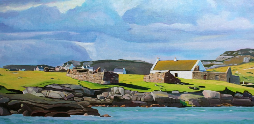
We have to walk along the sheltered beach and climb across a series of massive rocks to get a better look at the island. The island of Gola seems tantalizingly close, it’s only about half a mile. We can see the ruins of many houses, but also many painted white and with good roofs.
Houses on the south side of Gola Island
Seamas was very excited to see the island, as there is a possibility that his Donegal Coll forebears may have lived on the island. However, although we know his paternal grandmother originally from the Gaeltacht (Irish speaking area) somewhere in Gweedore, we cannot track her down in the records. There are lots of possibilities but no certainties.
Gola, is a small, very rocky and rather exposed-looking island. Mind you, I was looking at it from across the water, and it is consistently described as “beautiful” by visitors. The silvery quality of the light on the white-washed building nearest the shore certainly caught my eye. I tried to convey the quality of the light in my first painting of the island.
Spring Light on Gola (80x40cm)
We then clamber across another set of massive pink granite rocks to the headland nearest the island. It is more exposed here. You can get a better look at the houses. I am fascinated by the ribbon of little white-washed houses that look out towards the mainland. They look they were positioned with the prevailing wind (blocked by the hill to the west of them) and company in mind. There is a larger modern house set back from the old cottages.
I wonder whether that belongs to one of the few full-time residents that live on the island. My second painting of Gola, I think give you a sense of just how rocky the island is. The hills and fields are peppered with boulders, rocks and stone walls. The coastline along the south side of the island is a rampart of geometric rocks. No wonder the little harbour is tucked in on the sheltered eastern side of the island.
Oileán Ghabhla (80x 40cm)SOLD
The island is pretty small. It covers about one square mile (500 acres). Although it seems quite flat in comparison with Aranmore, it is “mildly hilly” on its west side, rising to 238 feet at Cnoc an Choillín and 212 feet at An Mhaol Mhór. These hills provided vital shelter for the houses that stretch along the east side. (Images taken from Google Streetview).
On the other side of the island is as statuesque sea-arch.
Sea Arch, Gola Island, Donegal
Gola was once inhabited by a surprisingly large community of over 200 souls. I looked across at this barren-looking land and wondered how on earth they could grow enough food to survive. Mind you, the land is not as bleak as the tiny fields of west Galway, full of stones. Yet survive they did, thrive even. Vegetables could be grown on the land fertilised with seaweed and turf could be cut from the bog to heat the homes. Many of islanders were fishermen and they would also travel to Scotland for seasonal to work each summer to supplement what they could grow on their small farms. Surprisingly, up until 1920s, the island population continued to grow, but it declined after 1930 and then became deserted in the late 1960s.
Yet, the island was never completely abandoned. Families would come and spend summer months here. Although most of the buildings on the island are derelict, many have been renovated by Gola families as holiday homes. The island now has mains electricity and water supply and a small number of people live on the island all year round.
Being an island the sea sustained island life but it also curtailed it. Bad weather could cut the island off from the mainland, especially in winter. The coast of Donegal frequently faces some very severe weather from the prevailing westerlies and the heaving Atlantic Ocean. Gola was immortalised in the sad lament “Baidin Fheilmidh” (Feilim’s little boat), a song about a Feilim’s bat which sets off for Gola and then Tory but was crushed against Tory island, sinking with poor Feilim in it. There are various versions of this song you can listen online including one by Sinead O’Connor but I think I like this paired back version best, which also has the lyrics in Irish & an English translation here.
There is a ferry service that runs from Bunbeg from June to September. Sabba, the ferryman, also runs facebook page under the name “Gola Ferry Service” and it it is a good idea to check before planning a visit.
We were too early in the year, sadly, to visit by boat. I am pretty sure that Seamas and I will be making a trip to Gola island in July when we are planning to be back in Donegal. We returned home to Burtonport for tea and biscuits to warm up in front of the fire.


")


