I love looking at maps and finding out the names of places. This is particularly true of the islands that litter the coast of West Donegal near the Rosses. I am always asking my husband, what island is that? He’s usually pretty good at knowing the names (I check on a paper map later). In the summer I spotted a house on a tiny slip of an island to the south of Arranmore. Can you see it in this photograph below?
View from Arranmore
Closer. See it now?
Inishkeeragh
I thought it was just one lone house (was that another house at the other end of the island, maybe?). What glorious solitude! What must it be like to stay on that island all with the spray of the sea so close looking at big Arranmore? This is my painting of the island. I was curious about the feint outlines of ruined houses I could see either side of the restored summer house. I wondered about them and their families.
Over to Inishkeeragh (SOLD)Map of Inishkeeragh (Google)
This is Iniskeeragh. Ireland (like Wales) is rich in descriptive place names. They usually describe are named after features of the landscape, such as hills, rocks, valleys, lakes, islands, and harbours. In Irish, its name is “Inis Caorach” which means “Sheep or Ewe Island”. So either sheep were kept on the island (it seems pretty small for that) or its a shape reminded people of a ewe, which might be more likely?
Inishkeeragh (Google)
After some research (online and in books) back home I discovered that the island had at least 12 families living there permanently, it also had a schoolhouse. I find this incredible for such a small, lowing lying island. It’s 650m x 300m (2132ft x 984ft) in size. I tried to work that out in football pitches. It’s the equivalent to 40 football pitches, so maybe its not as tiny as I think. It is very low. It’s no higher than 11 feet above sea level. Yet you can read their names in the 1901 census here. The family names of the farming families are familiar Donegal ones: Gallagher, Boyle, Sweeney, Rodgers, O’Donnell and a sole Bonner, Grace (35) who was listed in the census as a knitter, she was one of only 2 knitters on the island.
Ruins on Inishkeeragh:- Photo credit Roger Curry
These Donegal islands may seem remote to modern eyes, but they played their part in the culture and history of modern Ireland. Gola Island, Gweedore, may well have served as the model for Robert Louis Stevenson’s Treasure Island. Two men from Gola, Patrick McGinley and Charles Duggan, were aboard the Asgard, the yacht that brought arms into Howth in north county Dublin in 1914, in preparation for the Easter Rising of 1916. Tiny Inishkeeargh also had its connection with the wider world. Writer and political activist Peadar O’Donnell (1893-1986) was a for a time teacher’s assistant at the school on the island and he set his second novel, The Islanders, here. Peadar went on to become one of Ireland’s foremost radicals of the 20th-century.
School House:- Photo credit Roger Curry
Life was tough on the island. Roise Rua described her work on the island kelp-making as “tedious and exhausting”. The tenants had to pay rent of £50: £26 for the use of the land and £24 for the use of the seashore – making kelp, picking winkles or shellfish, dulse and the like.” Sadly, like many other Donegal island communities, such as Owey and Gola, the people of Inishkeeragh was forced to relocate to the mainland in the 1950s.
Inishkeeragh Village:- Photo credit Roger Curry
Sea levels played a big part as at least twice in the twentieth century an exceptionally high tide coinciding with a bad gale forced the islands to take refuge in the two houses that had lofts. They apparently spent hours “in terror, fearing the overloaded floors would collapse.” A storm in 1953 washed away the pier and the government of the day would not pay for it to be repaired. This meant that subsequent storms swept through the houses and within 5 years all the families were forced to leave the island.
Inishkeeragh – Photo Credit: Roger Curry
There was a reunion of Inishkeeragh families and their descendants in 2015 on the island. Internationally renowned Country singer, Daniel O’Donnell, was part of the celebrations (his mother was born on nearby, Owey Island).
Daniel O’Donnell and the Inishkeeragh Reunion
You can see the photos of the day on their facebook page here. You can visit the island with Arranmore Charters, be sure to book beforehand.
Addition sources for Inishkeeragh (Inis Caorachin) came from:
I have been back in Wales for three days now and the big difference from Donegal is the temperature and light. It is much warmer in Wales. Last week I was wearing a jumper – here I am in a T-shirt. In Wales, last night it was very dark by 10 pm. In Donegal, however, the light seemed unending. I struggled to sleep, despite being very tired, because although the sunset was after 10pm, it didn’t seem to get properly dark until after well after 11pm. Then it started to get light pretty soon after 4am!
I would sometimes wake in the early hours and look at the dark as a novelty. That’s something I’ve never done in Wales. Yet, I got used to this abundance of light. I made me feel active. With no television to slump in front of, I would find myself doing things after tea, such as the evening I found myself sanding a table at 9pm. I got used to life without news on the radio, although I did listen to some podcasts I had downloaded before I left Wales.
The day we visited Arranmore Island was a sunny Saturday. No jumper, just a shirt. There are two ferry companies that operate from Burtonport Harbour, the Red, and the Blue. They run all year round. In the summer months, they put on extra sailings. We plan to catch the 12.30 ferry, which is the Red Ferry. That’s the favourite colour of Seamas, my husband’s, beloved football team, Liverpool, so he’s happy. The ferry is very busy. It’s delayed by 10 minutes as the last car fills the boat to capacity. There are lots of teenagers and families on board. We stand by the rails as all the seats are taken.
Arranmore Red Ferry and an Oystercatcher
The journey to Arranmore is always a treat. The ferry is speedy. It takes not much more than 15 minutes to complete the three-mile journey. I love looking at the islands (and their houses) that lie alongside the route.
Rutland Island is one of the largest of these and lies to the west. There are some very beautiful modern houses on Rutland, alongside ruins which date from the 18th century. These were part of the planned settlement built by William Burton Conyngham. He also owned Arranmore Island. In my painting “From Ferry Coll” (below) you can see the remains of the fish landing and processing complex on the left side of the painting. There was also once a post office, houses, and a school-house here.
From Ferry Coll (SOLD)
On the eastern side, lies the islands of Edernish, Inishchoo, and Eighter. Here there are old cottages tucked in amongst the rocks. There is sparkling sunshine, but once we leave the shelter of the islands, the sea becomes quite choppy.
On the Way to Arranmore (SOLD)
When we arrive at Arranmore harbour there are lots of friends and families waiting for the ferry. There is a lot of waving and photos taking whilst we wait for the cars to drive off the ferry. Then the people can get off the ferry. There are lots of hugs, laughter, and chatter as the passengers finally get off the ferry. It’s a delightful scene.
Arranmore is well worth visiting. It is the second-largest Irish island (the largest is Achill, in County Mayo, if you want to know). It is seven square miles in size and it is dominated by an imposing hill called Cnoc an Iolair (“Hill of the Eagle”, 750 feet) which can be seen from most of the coast of Gweedore ad the Rosses. It has both sandy beaches along the south coast (three of them) and imposing sea cliffs (120 meters) along the west and north side of the island. Many of the islanders are native Irish speakers.
Many islanders used to support themselves through fishing, wild salmon in particular, but in 2006 the EU banned salmon fishing. This has caused a great deal of hardship and anger. It has also meant that many of the young people have been forced to move away in search of work, so the population of the island is dwindling and aging. You can watch a beautiful short film, “A Foot of Turf” about island life here.
Fortunately, the island has recently undergone huge technological advancement and has become the recipient of Ireland’s very first offshore digital hub. In celebration they wrote an open letter to American and Australia, hoping to entice new businesses to the island. Sadly, the story went viral and got distorted in the process. British tabloids, in particular, decided to reframe the story as the island being desperate for immigrants, “begging US citizens to move there” and decided to be offended that they “forgot” to invite British people, writing headlines like: “Anyone but the English”. This caused a great deal of distress on the island as this wasn’t what was intended at all. The letter was meant to appeal to American businesses to help boost the economy by giving islanders jobs – and visit the island.
So we are visiting the island. First, we made our way eastwards, towards the lifeboat station. We then backtracked and walk up the road past The Glen Hotel, which was the island’s first hotel in 1928. It was once the home of John Stoupe Charley, a Protestant from Antrim, who bought the island in 1855.
View Above the Glen Hotel, Arranmore
It was a long hilly road with a beautiful view across to the mainland. There were many old cottages and outbuildings here. The road was generally quiet but we were periodically passed by several cars. I like to take note of where cars are from, in Ireland registration plates in include letters to denote the county of registration. There were many with “DL” Donegal plates, but also plenty with “D” Dublin and Northern Ireland plates. Although I’d seen plenty of German and Dutch vehicles driving along the Wild Atlantic Way (past our house) there were none on this stretch of Arranmore road.
Over to the Rosses (Donegal, Ireland) (SOLD)
It’s considered good manners in Donegal (and elsewhere, of course) for the driver and pedestrian to acknowledge each other when the car has to slow to pass and the pedestrian has to clamber into the grassy verge. In Donegal, the driver will lift the index finger of his right hand. The pedestrian will similarly lift his or her finger but not necessarily raising the hand to do so. Smiles will be exchanged too. Nothing to exuberant, but friendly. It’s rare that this doesn’t happen, sadly it does on occasion and then it is followed by a short discussion between Seamas and myself about the drivers of particular makes of cars and/or people from NI/Dublin/hirecars.
Me on Arranmore Island, Donegal
We get so far and decide to retrace our tracks and walk in a big loop along the west side of the island, which provides us with sweeping views across to Burtonport and Dungloe. If you look carefully in the photo below you will be able to see the old courthouse to the right. This was built at Fal an Ghabhann (Fallagowan) around 1855.
Old Courthouse, (Arranmore Island) SOLD
Eventually, the road wound downhill. We could hear the sound of singing on the wind. A choir singing? We eventually came to a large white Community Hall, the doors were open and inside were lots of young people singing in Irish. These were some of the hundreds of teenagers who come to the island as part of a summer scheme to learn and improve on their Irish language skills.
As if to reinforce this, a tall teenage boy passes us and greets us in Irish. Seamas manages a greeting but then tells me that the lad had used a different form of words to the one he’d learned over 30 years ago. It seems that the Irish language is very similar to the Welsh, in that it has many regional variations in terms of accent, pronunciation, and words used.
House By The Red Wildflowers (SOLD)
We finally made it back to the harbour and had two delicious cheese paninis in the sandwich shop.
Here comes the Blue Ferry!
The journey back to Burtonport harbour on the Red ferry was very enjoyable, with the passengers still in a buoyant holiday mood, waving at the passengers on the Blue ferry as we passed. A holiday maker’s car alarm kept going off. His embarrassment levels pretty much matched that of his children’s amusement.
I kept a lookout for dolphins or seals but saw none. Only sea birds. An American told me that he’s seen Minke Whales in Clew Bay recently. We had seen dolphin on the way back from Tory island. He had a theory that there was a bumper crop of fish 8 miles out at sea, which was where the wildlife were. Usually, the waters around Burtonport would have plenty of seals and dolphins. That’s something to look forward to seeing another time.
For more on Arranmore and other Donegal islands in general doub;e click on the link
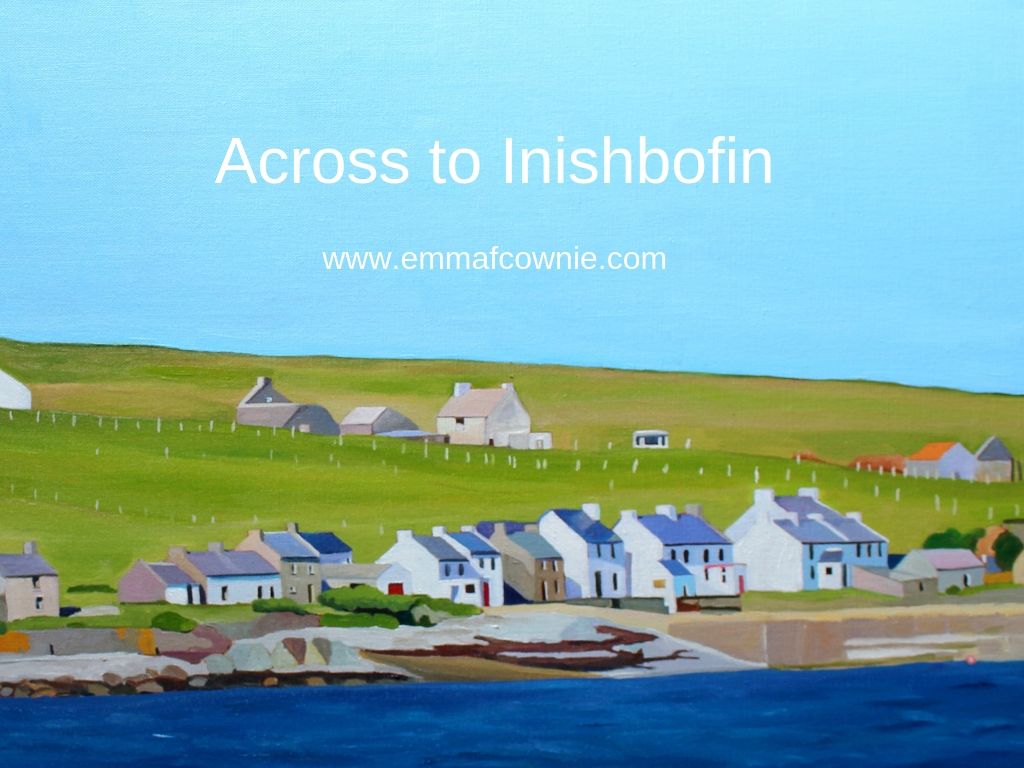
Inishbofin, Inis Bó Finne in Irish, means Island of the White Cow. There are two different islands off the coast of Ireland bearing this poetic name. The name suggests the importance of cows in early Irish society. This is not surprising at all as cows have been vital in many ancient human societies. The “other” Inishbofin is off the coast of County Galway further down south. The one I have painted is off the coast of Donegal, near Machaire Uí Rabhartaigh (Magheraroarty).
It was a chilly, sparkling day when we visited in late spring. We walked along the quay at Magheraroarty and watched a The Queen of Aran ferry come in and pick up some passengers for Tory Island 9 miles to the north.
Ferry at Magheraroarty Quay
Queen of Aran Ferry at Magheraroarty
Queen of AranMap of Donegal Islands
Much closer than Tory Island is Inishbofin. It’s a mere 3km (1.8 miles) from the mainland. I took photos of the houses on the island with my zoom lens. They were still very small.
Inishbofin, Donegal
I originally wanted to paint this whole stretch of the island’s coastline but I realised that without a more dramatic (cloudy) sky, most of the canvas would end up being a lot of light blue and a tiny strip of land at the bottom of the painting. So I chose a section of the coastline and focused on the details of the houses that I could make out.
I get a lot of pleasure from looking at the clean lines of the old houses – I also enjoy a landscape with no cars. If you have eagle eyes you will spot a solitary caravan on the hill above the main street on Inishbofin. The island is approximately 1.2km wide and 2km long with a small seasonal population of about 50 people, who are Irish-speakers. I believe, a few hardy souls live there all year round.
Here’s a lovely video about the people who live on the island in the summer months. It’s in Irish (as they are Irish-speakers) but there are subtitles.
I get very attached to my Donegal island paintings. I’m not sure why. Maybe its because I get such pleasure at looking at those unmodernized houses. I like the length of the image too. Perhaps it because, so far, I have looked across the sea at them and had to reconstruct the landscape with care.
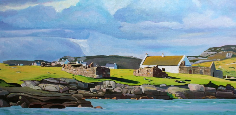
Across to Inishbofin (detail)
It’s hard to explain, but it’s like my mind has “felt” the shape of the land, the rise and fall of the shingle beaches, the spread of seaweed on the shore, the rocks and hills behind the houses. It’s usually my paintings of animals that find it hard to part with!
Across to Inishbofin SOLDInish Bofin beach
That house with a red front door on the right side of the painting is for sale.
Teach Johnny, Inishbofin Island
Many of the islands have seasonal boats. We are planning to visit one or two of these island in the next few weeks when we are back in Donegal. My list of islands to visit include:- Gola, Inishbofin, Tory and Owey. I don’t think we will manage more than two of those this visit. It depends on the weather and energy levels.
Here are my other Donegal island paintings (I have parted with two of these).
Spring Light on Gola – Seamas’s favourite painting!
My husband, Seamas, loves islands. He’s not alone, many people dream of living on or even owning their own private island. I just love looking at them and painting them. Which is handy, as the coastline of West Donegal is completely smothered with them. Looking out from the coast of Donegal, one of the longest in the country at more than 800 miles, is a bit like looking at the night sky and trying to name as many of the brightest stars as you can. Seamas seems to know most of their names without having to look at a map.
The larger Islands of the Coast of West Donegal
Around the coastline of the island of Ireland, there are 365 small islands, and a good number of those lie off the coast of Donegal. Wikipedia has individual pages for 20 of them, but there are many more than that. I can’t find an exact number. Many islands near the coast are little more than rocks big enough for some seaweed to cling to the edges of, visible only at low tide. Maybe these are just baby islands, islets. How big does a piece of land surrounded by water have to be to be an island, I wonder? If it’s big enough for some grass and a cow it must definitely be an island. There are quite a lot of those near Burtonport. The cows are well known for swimming between the island in search of better grass. I kid you not, it’s common off the coast of Inishcoo – click here for more evidence. I think the association between cows and island grazing is an ancient one as several islands take their names from cows, such as inishbofin (Inis Bó Finne) means island of the white cow and Calf island near Aran Island.
There are also about 100 sea stacks. Are these thin, vertical towers of rocks jutting out of the sea proper islands, I wonder? Slighter bigger and desolate are The Stags, or Stag Rocks, also known as The Three Sons of O’Gorra (Na Trí Mic Ó gCorra) which lie someway to the north of Owey island. Legend says that they were three pagan swimmers who were turned to stone by St. Colmcille the 6th Century missionary, also known as Columba.
The Stags
Then there are islands that have (or used to have) people living on them. Arranmore is pretty big (8 square miles) and is home to a sizeable community of about 500 people full-time residents. Some islands are easy to get to, such as Cruit, which has road bridge to the mainland, and Arranmore and Tory which have a daily ferry. There are others that have only summer ferry such as Gola and Owey Islands.
There are a lot of islands with no ferry but can be reached relatively easily by boat or kayak such as Inishsirrer, Inishmeane, Edernish, Rutland, Eighter, Inishillintry, Inishinny, and Bo, Go and Allagh, Inishmeane, Inishdooey, Insihbeg, Inishfree Lower but are close-ish to the mainland, and others that are pretty remote, even to people with their own boats such as Umfin, Tororragaun and Raithlin O’Birne and then finally there are the very remote ones are Stags Rocks mentioned above and Roan Inish. Some like Arranmore and Tory are inhabited all year round, others like Owey and Gola are mostly home to people during the summer months.
From Cruit Island
I love the descriptive names of the islands thus Cruit (An Chruit) means harp-shaped, Owey (Uaigh) means cave as there’s one under the island, Island Roy (Oileán Ruaidh) means Red Island, Inisheeney (Inis éanaigh), bird island and Tory Island, (Toraigh) means High Tower and when you see photos of the island you understand why that is a good description of the island.
Tory Island from the mainland
I have driven across the little bridge to long Cruit Island and I have boldly reversed my car onto the ferry to Arranmore and back again. I have spent a fair bit of time standing on the shore looking across the water at islands, Owey is a good example of this.
Owey IslandOver to Owey
My latest subject for this mainland-based island-gazing is Gola. Its name sounds vaguely sporting, forever muddled in my mind with football and trainers probably because I used to have a pair of Gola gazelle trainers back in the 1990s. The island has nothing to do with trainers or goals. The name Gola, or Gabhla in Irish, means “forked”. If you look at a map of the island the name makes sense. The fork is the split in the west face of the island.
Map of Gola Island
We set off on a sparkling afternoon in early April. The sun is out but it’s cold, with a chilly wind. I’d wear my big wooly hat in the car but the bobble on top is too big and it hits the headlining. So I drive without it on. In order to get to a good look at Gola, we drove past Donegal’s tiny airport at Carrickfinn, along a long single track road. There’s a lovely view of Mount Errigal off in the distance.
Errigal from Carrickfinn
The track then rises and winds its way past a series of isolated houses, both and old and modern. The road is a bit threadbare in places, in good condition in others.
We follow the road until we reach a fine modern house overlooking what I’d call a beach, but this sort of long stretch of curving sand is known as a strand in Ireland. I think this is Dunmore Strand (An Tra Bhan). We climb out the car (I leave my window open in my excitement), with hat and gloves on and various cameras slung around our necks and stuffed in jacket pockets. The tide is out so that I don’t realize that the long stretch of dunes reaching to the north of me, is actually part of a tidal island, Inishinny.
Dunmore Strand
The blond sand is strewn with majestic pink granite boulders and rocks. The clear sea is a most beautiful violet and turquoise. I have never seen anything quite like it. We spent a lot of time staring at the water, trying to fix its colour in our memories. The seaweed resting in between cracks in the rocks is a fantastic livid green.
Woolly hat back on, taking photos of Gweedore and Bloody Foreland
Beyond the dunes is in the distance to the east is Gweedore and the village of Bunbeg and Magheraclogher beach. The terrain is peppered with lots of little white houses, most of them modern. In the opposite direction to the east is a very different landscape.
View towards Gola
We have to walk along the sheltered beach and climb across a series of massive rocks to get a better look at the island. The island of Gola seems tantalizingly close, it’s only about half a mile. We can see the ruins of many houses, but also many painted white and with good roofs.
Houses on the south side of Gola Island
Seamas was very excited to see the island, as there is a possibility that his Donegal Coll forebears may have lived on the island. However, although we know his paternal grandmother originally from the Gaeltacht (Irish speaking area) somewhere in Gweedore, we cannot track her down in the records. There are lots of possibilities but no certainties.
Gola, is a small, very rocky and rather exposed-looking island. Mind you, I was looking at it from across the water, and it is consistently described as “beautiful” by visitors. The silvery quality of the light on the white-washed building nearest the shore certainly caught my eye. I tried to convey the quality of the light in my first painting of the island.
Spring Light on Gola (80x40cm)
We then clamber across another set of massive pink granite rocks to the headland nearest the island. It is more exposed here. You can get a better look at the houses. I am fascinated by the ribbon of little white-washed houses that look out towards the mainland. They look they were positioned with the prevailing wind (blocked by the hill to the west of them) and company in mind. There is a larger modern house set back from the old cottages.
I wonder whether that belongs to one of the few full-time residents that live on the island. My second painting of Gola, I think give you a sense of just how rocky the island is. The hills and fields are peppered with boulders, rocks and stone walls. The coastline along the south side of the island is a rampart of geometric rocks. No wonder the little harbour is tucked in on the sheltered eastern side of the island.
Oileán Ghabhla (80x 40cm)SOLD
The island is pretty small. It covers about one square mile (500 acres). Although it seems quite flat in comparison with Aranmore, it is “mildly hilly” on its west side, rising to 238 feet at Cnoc an Choillín and 212 feet at An Mhaol Mhór. These hills provided vital shelter for the houses that stretch along the east side. (Images taken from Google Streetview).
On the other side of the island is as statuesque sea-arch.
Sea Arch, Gola Island, Donegal
Gola was once inhabited by a surprisingly large community of over 200 souls. I looked across at this barren-looking land and wondered how on earth they could grow enough food to survive. Mind you, the land is not as bleak as the tiny fields of west Galway, full of stones. Yet survive they did, thrive even. Vegetables could be grown on the land fertilised with seaweed and turf could be cut from the bog to heat the homes. Many of islanders were fishermen and they would also travel to Scotland for seasonal to work each summer to supplement what they could grow on their small farms. Surprisingly, up until 1920s, the island population continued to grow, but it declined after 1930 and then became deserted in the late 1960s.
Yet, the island was never completely abandoned. Families would come and spend summer months here. Although most of the buildings on the island are derelict, many have been renovated by Gola families as holiday homes. The island now has mains electricity and water supply and a small number of people live on the island all year round.
Being an island the sea sustained island life but it also curtailed it. Bad weather could cut the island off from the mainland, especially in winter. The coast of Donegal frequently faces some very severe weather from the prevailing westerlies and the heaving Atlantic Ocean. Gola was immortalised in the sad lament “Baidin Fheilmidh” (Feilim’s little boat), a song about a Feilim’s bat which sets off for Gola and then Tory but was crushed against Tory island, sinking with poor Feilim in it. There are various versions of this song you can listen online including one by Sinead O’Connor but I think I like this paired back version best, which also has the lyrics in Irish & an English translation here.
There is a ferry service that runs from Bunbeg from June to September. Sabba, the ferryman, also runs facebook page under the name “Gola Ferry Service” and it it is a good idea to check before planning a visit.
We were too early in the year, sadly, to visit by boat. I am pretty sure that Seamas and I will be making a trip to Gola island in July when we are planning to be back in Donegal. We returned home to Burtonport for tea and biscuits to warm up in front of the fire.
I love painting the coast, particularly if it’s rocky. Owey Island, lies just a short distance off Cruit Island near Kincasslagh in west County Donegal. Strictly speaking there have been no permanent residents since the 1970s. [Photos from http://www.welovedonegal.com/islands-owey.html]
There is no electricity or mains water, yet plenty of people visit and many visit during the summer months. If you want to visit, there is a ferry service run by Dan the Ferryman.
View of Ireland From Owey Island (Ian Miller)
The name Owey, in Irish Gaelic “uaigh”, means cave. The island is a cavers, kayakers and rock climbers’ paradise.
The island is encircled by massive rock stacks and it also has an underground lake. As I am cave-phobic this video is the closest I will ever get to it!
I am fascinated by rock stacks and Donegal has plenty of them. I like to think of how these massive structures have gradually been eroded by wind and waves over thousands of years, forming first sea arches and then stacks.
I also love the colour of the rocks and the wild Atlantic Ocean. The ocean is incredible shades of blues, greens and mauves, mixed in with browns and frothing surf. Although I feel I am getting better at representing the layers of Donegal sky and clouds, but capturing the movement of the seas is still frustrating me.
Over to Owey Island (SOLD)
If you to find out more about Owey Island see Ian Miller’s Unique Ascent’s website for detailed descriptions and incredible videos.
Just thought I’d add a post script about the “Holy Jaysus Wall”. I think if you look at photo of it you will understand the name. It makes me feel ill just looking at it!
Holy Jesus Wall
SONY DSC
Irish climber and alpinist John McCune, climbed it in 2014.
Here’s a fascinating film clip from the 1970s about Owey Island’s postman, Neil McGonagle, who used to visit the dwindling population on Owey Island by small boat four times a week to maintain the island’s contact with the outside world.


")


")
")
")


")
")


