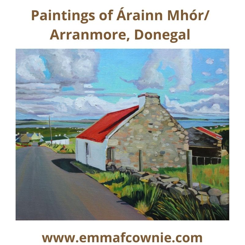
I recently join the Stair Árrain Mhór – Árrain Mhór History Facebook group and was overwhelmed by the positive response I received from the members when I put my most recent post online there. I was asked if I had any more paintings of Arranmore for them to see, so here’s a collection of all my paintings of the Island that I have completed in the last two years.
Where it reads (Private Collection) it means that the painting has been sold. I hope you enjoy looking at them.
This is only a short post because my cold from hell isn’t shifting and I have been ordered to rest by Séamas, which as you see, I am failing to do!
I like red and orange. Especially in winter. I have noticed that I like to paint red and orange things in wintertime. I previous years it has been red coats on the harbor beach at Tenby, or grandparents buying ice-creams in Brynmill Park. This year it’s the autumnal orange foliage of Donegal.
I painted this small painting over a number of days, over Christmas. I would usually paint a picture like this in one day but the light kept going and I wasn’t very energetic so I decided not to rush it and wait until the next day. I think my patience was well-rewarded.
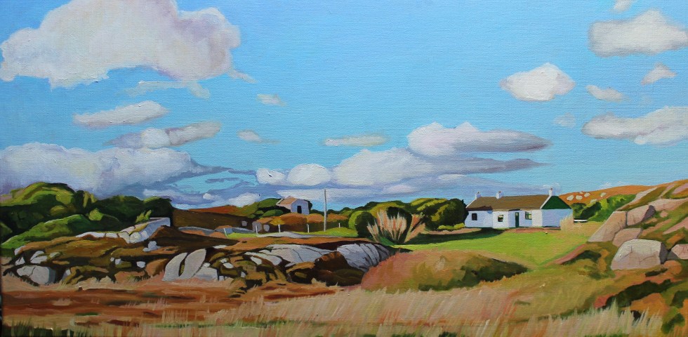
I have painted this house before, in a much larger painting. It’s interesting how the more distant view produces a cooler more airy painting.
I love looking at maps and finding out the names of places. This is particularly true of the islands that litter the coast of West Donegal near the Rosses. I am always asking my husband, what island is that? He’s usually pretty good at knowing the names (I check on a paper map later). In the summer I spotted a house on a tiny slip of an island to the south of Arranmore. Can you see it in this photograph below?
View from Arranmore
Closer. See it now?
Inishkeeragh
I thought it was just one lone house (was that another house at the other end of the island, maybe?). What glorious solitude! What must it be like to stay on that island all with the spray of the sea so close looking at big Arranmore? This is my painting of the island. I was curious about the feint outlines of ruined houses I could see either side of the restored summer house. I wondered about them and their families.
Over to Inishkeeragh (SOLD) Map of Inishkeeragh (Google)
This is Iniskeeragh. Ireland (like Wales) is rich in descriptive place names. They usually describe are named after features of the landscape, such as hills, rocks, valleys, lakes, islands, and harbours. In Irish, its name is “Inis Caorach” which means “Sheep or Ewe Island”. So either sheep were kept on the island (it seems pretty small for that) or its a shape reminded people of a ewe, which might be more likely?
Inishkeeragh (Google)
After some research (online and in books) back home I discovered that the island had at least 12 families living there permanently, it also had a schoolhouse. I find this incredible for such a small, lowing lying island. It’s 650m x 300m (2132ft x 984ft) in size. I tried to work that out in football pitches. It’s the equivalent to 40 football pitches, so maybe its not as tiny as I think. It is very low. It’s no higher than 11 feet above sea level. Yet you can read their names in the 1901 census here. The family names of the farming families are familiar Donegal ones: Gallagher, Boyle, Sweeney, Rodgers, O’Donnell and a sole Bonner, Grace (35) who was listed in the census as a knitter, she was one of only 2 knitters on the island.
Ruins on Inishkeeragh:- Photo credit Roger Curry
These Donegal islands may seem remote to modern eyes, but they played their part in the culture and history of modern Ireland. Gola Island, Gweedore, may well have served as the model for Robert Louis Stevenson’s Treasure Island. Two men from Gola, Patrick McGinley and Charles Duggan, were aboard the Asgard, the yacht that brought arms into Howth in north county Dublin in 1914, in preparation for the Easter Rising of 1916. Tiny Inishkeeargh also had its connection with the wider world. Writer and political activist Peadar O’Donnell (1893-1986) was a for a time teacher’s assistant at the school on the island and he set his second novel, The Islanders, here. Peadar went on to become one of Ireland’s foremost radicals of the 20th-century.
School House:- Photo credit Roger Curry
Life was tough on the island. Roise Rua described her work on the island kelp-making as “tedious and exhausting”. The tenants had to pay rent of £50: £26 for the use of the land and £24 for the use of the seashore – making kelp, picking winkles or shellfish, dulse and the like.” Sadly, like many other Donegal island communities, such as Owey and Gola, the people of Inishkeeragh was forced to relocate to the mainland in the 1950s.
Inishkeeragh Village:- Photo credit Roger Curry
Sea levels played a big part as at least twice in the twentieth century an exceptionally high tide coinciding with a bad gale forced the islands to take refuge in the two houses that had lofts. They apparently spent hours “in terror, fearing the overloaded floors would collapse.” A storm in 1953 washed away the pier and the government of the day would not pay for it to be repaired. This meant that subsequent storms swept through the houses and within 5 years all the families were forced to leave the island.
Inishkeeragh – Photo Credit: Roger Curry
There was a reunion of Inishkeeragh families and their descendants in 2015 on the island. Internationally renowned Country singer, Daniel O’Donnell, was part of the celebrations (his mother was born on nearby, Owey Island).
Daniel O’Donnell and the Inishkeeragh Reunion
You can see the photos of the day on their facebook page here. You can visit the island with Arranmore Charters, be sure to book beforehand.
Addition sources for Inishkeeragh (Inis Caorachin) came from:
When I decided to write this article I was not entirely sure I should. On Easter Monday I was gripped by the unfolding story of a massive, dangerous gorse fire spreading across the Rosses, a part of West Donegal. It worried that it would get completely out of hand and burn down people’s homes and destroy their livelihoods. I was checking twitter and my newsfeed for news of what was happening on an hourly basis to see if the fire had been brought under control. I was also worried about our own house in the Rosses. I love the area very much and feel attached to it. Yet, I felt guilty of being an outsider, what my husband calls a “Sasanach” (Saxon) or a “blow in” to the area only concerned about my house when brave local people were fighting desperately to quell the fires and save their homes. Actually, I was full of admiration for the community spirit and sheer grit and determination of the local people to fight the fire and save each other’s homes.
Donegal is often called the “forgotten county” on account of the belief that it is ignored by the government of Ireland, even in times of crisis. Maybe it’s because it’s so far away from the capital Dublin, or because of its location on the border with “troubled” Northern Ireland. On Monday that perception seemed to be borne out by events.
Over to Kinclassagh SOLD
It had been an unseasonably warm Easter weekend. It was the warmest for 70 years. This followed on from the warmest Irish winter on record, that was also drier than average. Unfortunately, this has dried out the moorlands in many parts of Ireland. In recent weeks there have been many fires over moorland in Ireland and the UK; Limerick, Kerry, Down, and across 700 acres of Yorkshire. Moorlands (and in Ireland the boglands) are “usually” by their very nature wet and soggy places but climate change has changed all that; in these drier conditions, (along with the heather and gorse that grow on them) have become tinder-boxes. Spring and early summer is the most dangerous time of year for gorse fires, between i.e. March and June, when ground vegetation is dead and dry following the winter period.
The Rosses in West Donegal seems particularly vulnerable to gorse fires breaking out. Gorse is a stubborn plant with thick branches, prickly thorns and vibrant yellow flowers during the spring and summer. It is also highly flammable. At least three gorse fires broke out last week; one near Kinclassagh, one near Crolly and another near Drumnacart, Annagry, which actually destroyed two homes.
House destroyed by gorse fire in West Donegal
House destroyed by gorse fire in West Donegal
The gorse fire that broke early in the morning on Easter Morning between Loughanure & Annagry was a different order of scary fire. The dry conditions coupled with the ever-present wind whipped it up and it quickly got out of control and spread over a large area threatened many homes. Fires in windy dry conditions will soon leap and fly. Just to complicate things there was a separate fire at Belcruit/Kinclassagh. It has since been claimed that a fire hydrant, in the village was blocked, preventing fire crews and locals from having a readily available water supply to combat the blaze.
When this fire started 5 fire engines came to try and put it out. By the end of the day, 15 fire engines had come from all over Donegal. One fire engine even came across on the ferry from Arranmore Island. Hundreds of local volunteers also came out to help, many of them were fighting to save their own homes from being destroyed. Trenches were dug, houses were doused with water. It must have been hard, dirty and frightening work. Farmers brought slurry spreaders filled with water to douse the area. Others looked after the people fighting the flames, bringing them bottled water and food.
Dousing the gorse
One fireman told a local newspaper, the Donegal Daily: “This is unreal stuff. I have battled a lot of gorse fires over the years but this is amongst the most dangerous. “Everything is bone dry and there is a strong wind so these are perfect conditions for the fires to spread rapidly.”
Photo credit Brid Sweeney
The local authorities and the Pat “The Cope” Gallager, the TD for Donegal, lost no time in asking (at 9.30am) for The Irish Air Corp for helicopters to help fight the fire. For some reason, they were not forthcoming. The Council waited and waited. Then a group of the firefighters fighting the separate fire near Belcruit were trapped by the flames. The area had been doused by water, so they weren’t in immediate danger, but it was a very worrying plight for them to be in. I can’t imagine what that must have been like to be surrounded by flames, like that.
Donegal County Council decided they could not wait any longer for the Air Corps, and decided to hire a private helicopter to fight the fire. It took 7 hours before the Air Corps finally arrived from Dublin on the scene at 5pm and proceeded to scoop up 42,000 litres of water from the nearby sea and lakes and drop them on the fire. They seemed to have made all the difference.
The Firemen at Belcruit escaped the flames when water was dropped on the fire, clearing a safe path for them. It must be a very difficult job aiming the bucket at the fire but from the video clip here, you can see the Air Corps are very good at it.
I got quite a shock when I saw the photo of Kinclassaagh below on twitter. It is a village I have painted a few times. You may be able to pick out the blue house to the left of the photograph below, which is in the centre of my painting “In the Shadow of Errigal”. The houses in the village are presumably being in doused in water in preparation of the worst-case scenario.
In the Shadow of Errigal
Fortunately, by the evening the fire was eventually brought under control and no new fires have broken out. The images of the aftermath are shocking. So many houses are surrounded by blackened gorse. They were clearly very close to being destroyed. It must have been the stuff of nightmares for the people who lived in them.
The fire will have been devastating for local wildlife and bird populations, their chicks and nests were not saved. This is the sort of event that Birdwatch Ireland calls “carnage in our mountains and hills, yet silence from our Government”. Rare plants whose precious seedlings have just emerged are also scorched along with hares, badgers, lizards, frogs, mice and all sorts of beetles.
The aftermath of the gorse firesThe extent of the fire
When I first heard of these terrible wildfires, I assumed that it was due to climate change and global warming. Yet, when I did a bit of research, I found that it was a bit more complicated than that. Yes, dry winters and summers are factors but it seems that there are other reasons that have contributed to this issue, not only in Ireland but in the British Isles as a whole. So it seemed to me that these issues need to be dealt with more urgently than they have been so far. For all our sakes. Tackling the problem of the gorse fires could actually help with the issue of climate change.
Most gorse fires are started by humans, although we don’t actually know how Monday’s fires were started, and it seems pretty clear that they were not started by a local farmer. In many cases, however, it seems that wildfires are started deliberately by landowners, or by arsonists, or even accidentally by tourists’ barbeques (as in the case of the recent fire in Yorkshire). Northern Irish fire service estimates that in one month in 2017 they dealt with more than 500 fires, of which 466, it believed, were started deliberately.
Gorse is so difficult to clear, its not uncommon for farmers sometimes burn the land so it can be cleared. It is currently against the law in Ireland to burn land from 28 February to 1st September. This is to protect nesting birds and their young. Paradoxically, part of the problem is that these fires don’t happen often enough. Many Irish hill farms have been abandoned or neglected and regular burning has not taken place, allowing layers of detritus to build upon the ground while gorse and heather have grown leggy, meaning that fires are harder to control. Thus, the rise in the number of gorse fires may have more to do changes in farming practices than climate change, as such.
In an ideal world, I believe, upland farmers would not be paid to clear land but instead, be paid to grow native trees on their land. Yes, call me a tree-hugging hippy, but by reintroducing trees, shrubs, birds, insects, and large mammals would have their ancient habitats restored. Ireland needs more trees. The world needs more trees. This is a good way to tackle climate change, instead of cutting down the rain forest at ever increasing rates. More trees also reduce the risk of flooding. A recent study by Bangor University (the one in Wales) found that water was absorbed 67 times faster by native woodland than on grass. Once 80% of Ireland was covered in trees, now it’s only 10.5%; the lowest in Europe (the average is well over 30%). Of that native trees comprise just 2% of the total! These incredibly low numbers are primarily due to human activity in the 18th and 19th centuries, and to a lesser extent also activities in the early 20th century.
The government does plan to increase Ireland’s tiny forest cover to 18 percent by 2046, under the Strategic Plan for the Development of Forestry, but unfortunately, the vast majority of new trees are Sitka spruce tree farms. These are non-native trees, planted in crowded, rows, robbing light from the forest floor. They do not encourage wildlife in the way that native trees would. They are barren places. They also need fertilizers and pesticides. They are patently, the wrong trees. The woodland League recently ran an excellent scheme supported by President Michael D Higgins, called “Forest In A Box”, involving 700 children in nine primary schools in Co Dublin, Co Offaly and Co Clare. The “box” in question is a native tree seed box – a metre square – which can provide up to 200 healthy native trees every two years. It would be great if this scheme could be rolled to the whole of the country, maybe there are plans to do so.
One thing they are not short of in West Donegal is community spirit. On Monday evening, the brave people of West Donegal will come together again, for a massive clean-up operation to collect all the objects like water bottles, spades and face masks that were dropped whilst fighting last week’s fire. Yet again it will be all hands to the pump. It will also be a good opportunity for the brave, hard-working people of Donegal to “debrief” after such a traumatic experience. This fire won’t be forgotten for a long time, but fortunately, no lives were lost.
(Here’slink to a beautiful Irish language series on Irish trees, it’s well worth watching, because it’s atmospheric, poetic and informative. Click the “CC” logo on the bottom right of the screen for English subtitles )
I am winding down the social media for a while because we are leaving the UK to spend some time in our house in Burtonport, Donegal, Ireland. The internet will be available on a very limited basis so I won’t be able to post on here until mid-April. I will be checking my emails but I won’t be posting much, if anything, on Facebook, Twitter & Instagram.
I have mixed feeling about the enforced “break” from social media. On the one hand, I hate the way how it sucks up all your spare time and energy and how FOMO (fear of missing out) has you checking updates. There’s always the fear that if you stop “spinning all the plates” that people will forget about you! However, I am certainly looking forward to reading books, listening to the radio (there’s no TV either) and sketching and painting for fun (not oils but watercolour sketches).
I am very excited/nervous about the whole thing because I am driving there and it’s a long, long way.
Please be aware that any artwork purchased after 25th March will only be shipped after 12th April.
I sounds mad, but I didn’t have a map when I was driving around Donegal. I sort of hoped I could buy one in a petrol station but I never did. The Hire Car people lent us a Sat Nav but I could not be bothered to plug it in and it stayed in the boot the whole week.
I am very lackadaisical when it comes to planning holidays, I think all my energy goes into the logistics of getting there. Anyway, I assumed that my husband would tell which places were worth visiting. Afterall, he had spent hours “flying” up and down the roads of Donegal on StreetView. I sort of knew where I wanted to go; Bunbeg, Bloodyforeland, Falcaragh, Dunfanaghy, Derryveagh, Kincasslagh and Dungloe and the distances between them were not very great.
Donegal Islands Map
On the only properly sunny afternoon we had in Donegal, I took a left off the road from Dungloe to Kincasslagh. The sign said “Cruit Island Golf Club”. I reasoned that golf clubs are usually located in beautiful places, near the coast. So I followed a single track road and over a small concrete bridge on to Cruit Island. If you look at the map above, you can see that Cruit Island is long, three miles long, in fact.
Bridge to Cruit Island
Cruit Island at Low Tide
After a pleasant drive along a single track road, and passing what can only be called mansions at the north end of the island, we reached the golf club. Now in the UK golf clubs can be funny about other people coming onto their property, but there was nowhere to turn the car so I kept driving. Eventually we reached the golf club car park which looks out across wild waves to an island. This was no calm inland lough. This was the Wild Atlantic. The wind was fierce and the waves crashed and boomed.
Owey Island, Donegal.
It was mesmerising. The island was just across the turquoise water. It was dotted with houses, some clearly derelict, others in good order. I didn’t know it at the time but this was Owey island.
Quay on Owey Island
It turns out that Owey island is uninhabited for much of the year, having no permanent residents, but people do live there in the summer months. It was last inhabited on a full-time basis in the mid 1970s. The last residents were three old boys who were moved to the mainland of Donegal, or as the islanders call it, Ireland. All the houses were built on the south side of the island, facing Cruit Island Golf Club. The north of the island is too rocky and too exposed to the north Atlantic Ocean gales.
Buildings on Owey Island
My eye was drawn to one building in particular. Standing on the brow of a hill, its missing roof caught my attention. It had also had a walled yard behind it. I was too far away to be able to tell whether this was a derelict old building or an incomplete new one. There are many incomplete “new” buildings littering the Irish landscape.
This turned out to be the old school. The walled yard was the play ground. It was a tiny school with just one teacher who would have to teach all ages of the small number of island children. It was a school for the younger children, and when they were old enough the children would then be sent to the mainland for their secondary school education.
Apparently, the school children had to bring a sod of turf to school each morning. The turf was fuel for the fire and the idea was that they provided the heating for the school room in the cold months. It has been pointed out that as the teacher’s table and chair were at the front of the room, they would usually sit right in front of the fire. When I used to be a teacher, I used to teach in a “temporary” demountable classroom (it had been there for 40 years) and in winter, I would often stand next to the gas fire, myself. So I liked that idea!
Donegal, or Dún na nGall, meaning “fort of the foreigners”, felt like a very foreign place to me.
Donegal number plate
Or rather, I felt like a foreigner there. Every time I opened my mouth to speak, I was very aware of how very English I sounded compared with the Ulster and Scots accents I heard around me.
Donegal is one of the nine counties of Ulster. Historically, Ulster lay at the heart of the Gaelic world made up of Gaelic Ireland, Scotland and the Isle of Man. It looks a lot like the landscape of Scotland too. It is in the Republic of Ireland but six of the other counties of Ulster were partitioned from Ireland to form Northern Ireland in 1921. My husband grew up in one of these counties although his paternal grandmother came from Gweedore, in Donegal.
My husband is from Northern Ireland, so his accent fitted pretty seamlessly with all the others. People understood his jokes and laughed heartily at them. I sometimes notice, back in Wales, people don’t always understand his accent and just nod and agree with him, missing his wonderful witticisms. Here, however, he came into his own. He stood and chatted with people as if they were long lost friends. It made me realise what a daily effort it must be for him to live away from his country.
Here, it was me that was a fish out of water. My husband often had to “translate” behaviour for me. Like the time we ordered veggie burgers and chips in a cafe in Falcarragh. The meal that arrived on our table was massive, American-size portions of food, in fact. As I tuck into my meal, Seamas quietly told me that I had to eat everything, or else the cafe owners would be offended. Oh dear! This was some challenge. I valiently made my way through the burger and many chips but ultimately failed, leaving a few chips and a bit of salad behind. However, I didn’t need to eat again until Breakfast the next day. All this food gave us energy to drive north-west to Dunfanaghy and then north to Horn Head.
In Dunfanaghy, I came a cross a billboard that informed me that Puffins visited Horn Head. My excitement turned to disappointment, when I soon realised that Puffin season ran from March to September, and we had missed them!
Horn Head Puffins (not seen by me)
Views going up to Horn Head, views towards the mountains of Derryveagh
Across to Dunfanaghy, Donegal (SOLD)
Horn Head and the view to the north.
On our way back to the car, we scrambled up the top of a hill. The land feels foreign to me. It’s not like the largely-benign landscape of Wales. If you step off the path or a rock, you don’t quite what you will meet. Springy heather, can drop away to soggy nothingness, peatland below. This happened to me a couple of times and made me very cautious.
View towards Dunfanaghy
Just to end with a video of the view from the top of the hill. I still haven’t mastered the slow panning shot. Wind is a constant feature of the “Wild Atlantic Way”. I like to think of it as a lot of fresh air, the sort you just want to drink in.
The night before last, I woke up in the dead of night, not sure if I was in Ireland or Wales. It’s now five days since we returned from our week in Donegal, in the Republic of Ireland.
It’s taken that long to recover my energy levels. I hadn’t fully recovered from the virus that keeps coming back, and it was adrenaline that powered me round the place. I don’t get out much, to be honest, and everything was exciting to me; the airport in Cardiff (on 4 hours sleep), the flight over Wales, looking down at our house, even the long wait in Dublin Airport for the connecting flight to Donegal was interesting. I hadn’t been to Dublin for years (and by years, I actually mean a couple of decades) and it had changed beyond recognition. I enjoyed watching how things are organised and how they connect (when I am not in charge of them, that is).
The final flight into Donegal airport was stunning. Most of Ireland is a patchwork of small green fields until just before you reach the approach to Carrickfinn Airport. Then the fields melt away to be replaced by an expanse of mountains and rusty red boglands.
Donegal is at the north-western corner of the Republic of Ireland. Facing out towards everything the Atlantic has to throw at it. It is very big, very beautiful and very empty. More people live in the city of Swansea (241,300), than in the whole of Donegal (158,755). Swansea is 380 km² and Donegal is 4,861 km². No wonder Swansea feels very crowded.
Owey Island from Cruit Island
The stunning landscape is immediately apparent, but what took a little longer to dawn on me was just how really friendly and well-mannered people are. People wave and say hello when you pass them in the street, when crossing a road cars pause and stop to let you cross, when driving, its a battle of “who’s the politest” at junctions. When people stop for a chat, they chat for 20 minutes or even more.
A straight road
I love driving around Donegal because the roads were pretty empty. I am not a fast driver, and wiggly roads without crash barriers are certainly not on my list of favourite things. Add a drop down a steep hill, and you have me driving at a snails’ pace. So what a joy it is to crawl along these hairy roads with no one behind my car. In fact, at Horn Head, I was getting nervous about sheer drops and bends so I pulled over and left my car to walk the last few bends to the viewing point. No cars passed us, either the way up or on the way down. It was a joy.
I think I was happiest walking along the wind-swept beaches looking at the sea. The wind was always blowing. We quickly developed “Donegal-hair”, from the wind. My husband’s hair started to look that guy from the 1980s band Flock of Seagulls. On some beaches, the sand was almost white. I loved the Atlantic Ocean. It was a strong dark blue, but where the waves lifted, green showed through. The sea was so clear that the shallows, were green too.
Ballymanus Beach
One of my favourite beaches was Ballymanus, which is just round the corner from Carrickfinn Aiport. From the rocks you can see Mount Errigal, the highest peak in Donegal. It’s a curious dome-shaped mountain and looks like it should have been a volcano, but I don’t think that it was. In this painting I tried to capture the deep blue of the Atlantic and the ever-changing cloudscape. The colours of Donegal are very different to South Wales. There are more purples and greys and the light is cooler, less golden. Painting this picture has helped “embed” Donegal for me. It will be in my dreams for a while longer, I think.
Mount Errigal from Ballymanus Beach, Donegal (SOLD)


 I think I was happiest walking along the wind-swept beaches looking at the sea. The wind was always blowing. We quickly developed “Donegal-hair”, from the wind. My husband’s hair started to look that guy from the 1980s band Flock of Seagulls. On some beaches, the sand was almost white. I loved the Atlantic Ocean. It was a strong dark blue, but where the waves lifted, green showed through. The sea was so clear that the shallows, were green too.
