I managed to make it down to Rhossili Bay this week. It has been raining on and off for weeks. I have been painting in my attic studio listening to the rain thundering down and I have got quite tired of that sound. So when I was greeted by clear skies I decided, on a whim, to drive down to Rhossili to see the autumn colours.
Rhossili has a wonderful windy wildness to it. It’s unlike the rest of the Gower Peninsula. The trees all lean heavily away from sea and the prevailing westerly wind. As I drove into the village I was caught up in a sheep-jam. A herd of sheep was being moved from one field to another. They were packed into the little road and had stopped the traffic (it was three cars actually). I watched the mob of sheep as they swirled in front of my car and past me. They were Welsh Mountain sheep; only a few had horns. Their creamy fleeces were spotted with brightly coloured red and purple “smit” marks. These are marks painted by their farmers that denote ownership. One moment they were packed around me and the next they had moved on.
There was space in the church car park so I parked and put my donation in a slot in the wall. This car park is closer to Rhossili Beach. If I had wanted to walk to Worms Head itself the National Trust Car park with its facilities (loo block and shop) would have been better. From here I walked down a stepped concreted path down towards the beach. It seems strange but I have never walked on this particular path before. I don’t know why. I have always walked parallel to the beach along the cliffs paths (one on the top of the downs and one in front of the rectory). I wrote about the coastal path in several blog posts and in my book, Footnotes: An Artist’s Journey Around the Gower Coast.
Rhossili Bay (View From the Path)
So I followed the path downhill and got a different view of the Worm. The bracken had died back to a wonderful russet colour (one that I associate with wales) and the sea was a beautiful turquoise blue. The tide was out and the tidal island, the Worm (Wurm) rose up above the waves on the horizon. I looked at how the light caught the back of the Dragon and remembered how arduous walking across it was.
Over to Worms Head SOLD
The walk down to the sea was quite steep but easy. The final descent was down a ramp of gravel. The vast beach was surprisingly populated for a term-time day in the week.
Worms Head Rhossili
Of course, I could not pass up the opportunity to visit the remains of the Helvetia on Rhossili Beach. The Helvetia was a Norwegian ship bound for Canada that was wrecked in south-easterly gale on Rhossili Bay over 130 years ago on 1st November 1887. In the Instagram age, given its picturesque location, its not surprising that it has been photographed and shared countless times.
The Wreck Of The Helvetia, Rhossili, Gower SOLD
I walk across the beach to bottom of the vast 200-foot cliffs, looking at the colours and light. There are seagulls scattered across the beach and when I turn back I can see the Rhossili Downs and the Od Rectory reflected in the outgoing tide.
Rhossili Reflection
On the far edge of the beach, I was surprised to discover the remains of another shipwreck in the sand. A bit of online research and I discover that this is Vennerne, apparently, it is known locally as the Vernani, and it was dashed to pieces under the Rhossili cliffs in 1894.
Another Wreck on Rhossili Bay
There is quite a strong breeze. When the clouds roll in it starts to feel cold. The clouds create a softer light. The grays and purples dominate. I am glad I have my woolly scarf on and start to make my way back to my car. The path hill is pretty steep and the climb warms me up.
Cloudy Worms Head
The next day, I am tired from walking across the sand but it doesn’t matter as its raining again.
I am delighted to announce the publication of my latest book “Footnotes, An Artist’s Journey Around the Gower Coast” which is based on my walks and blogs of 2018.
My book on Medieval History
Many years ago I turned my Ph.D. on Medieval History into an academic book. That was jammed packed with footnotes and had almost no pictures (except for the front cover) but it did have some maps hand-drawn by me. I felt quite odd when that was published. I suffered terribly from imposture syndrome, then as now, and it almost felt like someone else had written it when I looked at the words on the book. Don’t get me wrong, I had written every last bit of it, the text, the footnotes, the index but it didn’t feel like it had much of “me” in it, except maybe in my dedications. I think my parents and Seamas, who was my boyfriend back then, appreciated being thanked for their support.
This book is quite different. Ironically, despite the name, the only “footnote” in it is the title. It’s a bit of a joke, I guess! This book has a lot more of “me” in it. Yes, there still some local history and stories about Gower, but its mostly about the walk and dealing with my anxieties.
I had spent weeks editing it and sort of ran out of steam when I reached the part where I had to upload it to the Kindle website. Thankfully, my husband, Seamas, came to rescue and was midwife to the whole venture. He did the final editing and proof-reading and it uploaded to the website. Which sort of sums up our relationship, he’s always there to help me over the “humps”, not just as a cheerleader but as technical support and he also provides so much inspiration. So thank you, Seamas.
I also want to thank my parents who have always supported whatever I have done. My mother is a fervent “liker” on Facebook. Their house has many of my paintings hanging on their walls, which is a compliment in its self as superfluous objects are either returned to the donor or end up in the local Charity shops. I also want to thank supporters on Instagram who tell me that they have downloaded from Kindle or bought the physical book.
I hope that people enjoy it as much for the walks and stories about Gower, as for my paintings!
I am just going to post the photo of this woodland painting, it seemed to take all week to paint. I kept rushing out to take photos of the woods in the glorious (but worryingly warm) February sunshine we had early in the week, so I sort of lost my usual rhythm with the painting. Still, I doubled down and worked hard and I am pleased with the final result.
The clouds of pinkish trees off in the distance are hundreds of hazelnut catkins, catching the light. What I love about this ancient woodland is that, although its managed, and trees are cut back, and paths kept clear, fallen trees are allowed to rot in place. I have painted at several fallen (and falling), trees in this composition. Three lie in the stream, the other reaches across the canvas in an arc.
I’ll let you into a secret. I have been known to hug a mossy tree. They are like nature’s sofas. they are soft and springy. They provide so much for the eco-system. Mosses, lichens, ivy, and fungi grow on their surface and the creviced bark provide homes for hundreds of insects. The dying trees send nutrients back into their roots, passing on to their neighbors (who are usually their offspring). In our urban lives, we are insulated and somewhat shut off from the ebb and flow of natural life. My visits to the woodland remind me that life and death are constantly happening and that release from one form of life provides life for others. Don’t believe all that hype about “survival of the fittest”, nature is more sophisticated than that. It is all about balance, no one species rules the woodland, thousands live, cooperate and thrive here.
Here’s a fascinating TED talk about how trees communicate.
Me at Work (with Mitzy)
This blog is made up of 5 photos/images that represent the stages that go into the process of creation of a woodland painting. The first photo is the most joyous. Wandering around the woods (read more about this very special place here), taking photos and marveling at the light. On this day the light was perfect. I was delighted by the way it illuminated the leaves, the moss, and the grass. I was also excited by the fact the woods and stream were flooded with light in a way I had not quite seen before. The time of year and the time of day all affect conditions. No two days are the same. Enjoying the sunshine was the easy part.
Work in Progress #1
Now for the hard work. My woodland paintings are different from my other paintings. I paint them in a different way. They are more of a semi-abstract construction and less organic than my paintings of clouds, coasts or people. I can’t exactly explain how I ended up doing this, I think it was when I was in my fauvist/refractionistphase. It sort of like constructing a giant puzzle and my head usually aches afterward! So I sketch out the basic position of the trees, stream and the main shadows.
Painting is a lot of problem-solving. I have to decide which order to paint different sections of the canvas. Some parts I want to dry and then go back and add detail. So I start by flipping the canvas “upside down” and painting in the light blues and mauves of the sky. I also need to convince myself that this painting will work so I paint in the tree trunks to “anchor” the painting. I look at the painting in a small mirror – this is a way of allowing me to see it in reverse, and trick my brain into seeing it like other people do (rather than what’s in my head). That’s day one of painting.
Work in Progress #2
On my second and third day of painting, I spend a lot of time thinking about colour and how to mix the right shades. Getting the different greens right is vital, from the fresh yellow greens to the very dark hues. The hazy trees in the middle distance are difficult to gauge as mixing green with purple makes a dreadful sludge on my palette and nothing like the colour I want. I am anxious about the dark green on the opposite river bank on the left hand of the painting. I worry about getting it right. I have to be able to represent the damp dark greens effectively, without drawing too much attention to them. I mark in the darkest part of the bank and leave them for the next day. It is slow work.
Work in Progress #3
On the final day of painting, I pick up speed and tackle the far river bank. I attack the most interesting part by painting in the light on the leaves and the purple shadows at the top of the bank. The purple shadow then blends into the green and by the time I have finished with the bank I am pleased with it. The part of the painting that frightened me the most makes me the happiest. Ironically, no will notice probably it. That’s how exactly it should be.
“Path by the Stream”
The final stage of the painting is solving the showed foliage in the lower centre of the painting. This I simply into blocks of colour. I want to focus of the painting to be the hazy light at the top part of the painting and I don’t want to draw the eye to the foreground at the bottom of the canvas. In my mind, I struggle with this process. There is alot of indecision. The literal part of my head wants to paint it “as it is” but my artist’s head is trying to reduce the colours into blocks. To help in this process, I move my reference photo onto a chair so my myopic vision can no longer see the details. I push on and eventually, the canvas is covered.
I then will leave the room to make a cup of tea and return with the express purpose of “surprising” the painting. This way I can see it with fresh eyes from the other side of my studio and decide if I am happy with it. I am.
From further away
I am delighted to report that I sold “Path By the Stream” to one of my most valued collectors, who has bought many of my works, in beautiful Kent, England.
I have started my next woodland painting, if you want to follow its progress like & follow me on Facebook.
It’s that time of year again. When the slanting sun makes you believe that spring is just around the corner. Snowdrops and crocuses are flowering in parks and in the woods. We spent the last two days revisiting my favourite stretch of Gower woodland. It follows the stream that meanders from Ilston along the Ilston Cwm to Parkmill (the stream then it crosses the A4118 and winds its way into the sea as Pennard Pill). You can see it on an interactive map of Gower here .
Ilston to Pennard
Yesterday, we revisited the Parkmill end of the woods (you can read about the Ilston end of the woods here). These trees are technically part of Kilvrough Manor woods, although Kilvough Manor itself, is quite a distance off on the other side of the A4118. The woods have been here for hundreds, if not thousands of years. The trees are “ancient semi-natural and broadleaved, made up of a canopy of Ash, Oak, Beech, and Elm, with a Beech plantation”. They have given me years of inspiration for painting.
Woodland near Gower Inn
Very early spring is my favourite time of year because the sun cuts through the bare branches and illuminates the ground. The shadows create an exciting combination of colours; the beech leaves on the ground are an interesting orange and mauve, and the rich brown earth is almost a dark purple, that reminds me of a dairy milk wrapper.
Diary Milk purple
In the past, I have usually visited this part of the woods in the morning. I feel almost stupid when I see how different it all looks in the early afternoon.
Of course, nature is a giant sundial. The trees cast shadows in different directions, depending on the time of the day and the time of the year. If you come too early the trees nearest the car park lies in darkness, as the sun has not risen above Pennard.
Pennard Pill
If you come too late the same trees are in the shadow of the hill that rises up beside the stream to the west. When the trees are illuminated it’s very exciting. It’s like an incredible show that is switched on and off, depending on the light.
One impulse from a Vernal Wood.
As the river meanders along the valley the path crosses it by a number of sturdy bridges. I have painted many of these over the years. There’s the 1950s concrete and metal railings one, nearest the Gower Inn.
Bridge Over Ilston River
From both sides, if the light allowed it.
A Bridge in Ilston Cwm
There is a beautiful wooden bridge, further along, that resonates with walkers’ footsteps as the stride across it.
The Bridge to ParkmillThe Bridge
In the summer, when the stream is low, I have waded through the water under this bridge and listened (troll-like) to the sounds of people walking above.
Yesterday was a day of epiphanies. I stood listening to the wonderful cacophony of birdsong and soaked in the sight of the light catching the leaves I realised that what made this place so special was its sheer age. People have walked along these paths (and crossed older, long gone bridges) to reach the places of worship for many many years. Over 300 hundred years ago a Baptist chapel was built by this bridge by John Miles and people travelled from miles around to reach it. At Ilston, much further along the stream, there has been a religious cell, or church since the 6th century. These woods have been a place of contemplation for centuries, and it feels like it. Modern people may or may not contemplate religious matter, but it is difficult not to get drawn into contemplating the rhythms of the natural world.
Light Catching the leaves
For me is the moss that marks this woodland apart from others. The moss catches the slanting light and the trees almost look like they are wearing halos.
Light Catching the Trees
In some parts of the wood, the moss is so thick they cover the tree like padding.
Thick Moss
Moss is odd stuff. It is a plant, with stems and leaves, but no true roots and no flowers. It needs damp conditions to reproduce. The moss grows so thickly here because it’s very damp in South Wales, it rains a lot. The stream also creates a lot of dampness. The moss absorbs huge quantities of water. It actually helps to soak up rainfall and create a locally humid environment. There’s also lots of lichen on the trees. This is a good sign as it only grows where there is clean, unpolluted air. Lichen, apparently is not a plant, although plant-like. Its sort of fungi. Lichens amazingly are some of the longest living things on the planet. They grow very slowly and live very long lives, a bit like the ancient yew tree in Ilston churchyard.
LichenIlston Yew Tree
To give you a feel for the beauty of the place I have uploaded a couple of short videos. The splashing you can hear in the first clip is my dog, Biddy walking in the water, hoping that I will throw a stick for her.
Here she is!
Biddy (Look I have found a stick for you to throw!)
Join my mailing list to keep up with the latest paintings.
Once-upon-a-time I worked full time as a teacher in school of just under 2,000 pupils and I would teach approximately 150 pupils in a day. That’s a lot of faces to put names to every day. I was pretty good at learning all those names too. These days, however, I might only speak to a handful of people in a day; my husband, my neighbour and local shopkeepers. So, when presented with an opportunity to met with and chat with to new people I relish it. Clyne Christmas market gave me a lovely opportunity to talk to all sorts of people.
I am pretty new to running a stall, I did it once about 4 years ago. I really enjoyed it back then but teaching commitments meant that I did not have the energy to keep doing it. That has changed now. I have the energy and the time to pursue this and yesterday I had a stall at the first Clyne Farm Christmas market. I realise that I have a lot to learn.
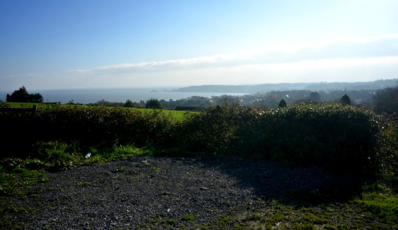
Clyne Farm sits on top of Clyne Common, high up above Swansea. It has sweeping views towards the sea-side village of Mumbles and across the massive Swansea Bay.
View Towards Mumbles (from the car park)
Once upon a time it was a riding stables but in recent times it has transformed itself into an top-class accommodation and activity centre.
Minnow at Clyne Market
Sparkly Bow Stall
Yesterday was their first Christmas Market and we were blessed with sparkling crisp sunshine. The photos above were taken in the first half an hour before it got busy. The crowds ebb and flow. After a quite half an hour, it is quickly jammed with families carrying babies wrapped up to the eyes in jump suits and bobble hats. The little girls are drawn to the “Sparkly Bow” stall further down my aisle. The table covered in glittery objects is exactly the right height to catch a 5-year-old’s attention – at eye-level.
This first onslaught is followed by another wave of families with dogs on leads, and in carried in their arms. There are lots of woolly coated “cockerpoos” (Cocker Spaniels Crossed with Poodles) and some sharp-eyed border collies. They take in everything. Later as people leave for lunch in the other hall, it becomes calmer. People are clutching bags with their purchases. I recognise some people who came around earlier return to buy. It’s in the post-lunch calm that I make most of my sales. I chat with many of the people in the hall. My cards of Mumbles Pier starts a number of conversations about a controversial development of the Pier Head area that the local community (Mumbles Action Group) are currently fighting.
Clyne Christmas Market
I manage a quick break and visit some of the animals on the farm. I’d met Ted the collie and Flo the goat and her surrogate daughters, the sheep Brillo and Lucy, yesterday.
Ollie the colt (6 months old)
Along a muddy tack there children’s pony rides on offer. I had to make a special journey along a different muddy path to see Peggy the Pig. She is massive. I give her a pat on her broad back and was surprised that her back was covered in bristles, not wiry hair. Her floppy ears cover her eyes, like nature’s sunshades, but it can’t be easy for her to see. I was told by Sarah who works at Clyne, that Peggy is pretty laid back and is a “morning” pig. She is active in the morning and spends her afternoons sleeping. Someone speculates that she’s a Gloucester Old Spot. I assume that they have only one big spot but looking it up later it seems that they were probably right and she’s an “Old Spot”.
Peggy the Pig at Clyne Farm
The hall is filled with bright sunshine but by the late afternoon, I’m starting to feel the cold. Although there’s carpet in the hall the concrete floor underneath is cold. I run to my car to fetch my woolly hat. As the afternoon wears on I notice that the tip of my nose is numb! After 5 hours in the hall, my feet are starting to feel like blocks of ice. The girl opposite me is wearing thin daps and ends up sitting on her chair with her feet tucked under her. At four o’clock the sun is low in the sky and someone mentions that there’s Christmas Parade in town at 4pm. That seemed to be the signal for the stall-holders to pack up and within minutes the hall is bustling with activity as the stalls are rapidly dismantled. I drive home with the sun setting over Clyne Common.
Me and my stall at Clyne Market (my bag handles have just snapped!)
What I learnt
Get new cash bag – my beautiful leather cash bag handle snapped as soon as I put it on. Although I tried to tie a knot in it, it kept coming undone.
Thermal socks are needed (possibly 2 pairs).
Clear prices on each rack. We had a price list but it was difficult for people to read it. Bull-dog clips or cardboard luggage labels are good for this.
Paper bags for purchases – brown or white. Environmentally friendly and they look cool
Camping chair – a wooden chair was hard to sit on all day.
Paypal card reader or izettle for mobile payments. Not everyone has enough cash on them and you don’t want to lose sales
Presentation is vital. Rustic chic is cool – I had wooden racks and a table easel but more wooden boxes for cards would be good. I learned a lot from Ed Harrison at Minnow across the hall. His presentation was excellent.
I did not walk the length of Worms Head at the same time as my other Gower coastal Walks. This was because you cannot walk its full length between the 1st March and the 31st of August – as the last part of the Worm, the Outer Head, is closed in order to protect nesting seabirds.
So I waited until late October for a sunny morning and a low tide to set off on my adventure. It was certainly an adventure as I travelled alone and there was plenty of scope for “mild peril” and twisted ankles and, at one point, there was definitely outright fear. More of that later.
The drive down to Rhossili was beautiful. Autumn sunshine lit the russet trees and the long shadows stretched across the road. The forecast was for a fine sunny day but by the time I arrived at Rhossili, it had clouded over. I got of my car and wished I had brought a woolly hat instead of my sunhat jammed at the bottom of my bag underneath my sandwiches, banana, and the compulsory chocolate biscuits. The biscuits had been lurking down there since my last walk several months ago, but as they were individually wrapped I decided they’d still be very edible. The walk down the National Trust car park to the coast guard station at the end of the headland took longer than I expect it.
Worms Head (from Rhossili Downs)
I think this is because I am usually so mesmerized by the sight of the “Worm” that I don’t really pay attention to how far I am walking. The Worm (“Wurm”) means dragon, and it was given this name by the Vikings who regularly sailed the Bristol Channel over a thousand years ago.
Worms Head
It is a long tidal island that undulates westward like a sea beast. The shape of it changes depending on which angle you approach it. Sometimes it seems coiled, other times in snakes from side to side.
Towards Worms Head (SOLD)
I think I look up the tide times for Gower more often than most people, except for surfers. Every time I go to the coast I like to know if it going to be a low or high tide, depending on whether I want to photograph it or swim in it. If you want to visit Worms Head, a low tide is essential because the causeway over to the islands is only safe to cross 2 and a half hours either side of low tide.
I know that to be caught out ensures an extra long stay on the island (as happened to Dylan Thomas once), because swimming across the short stretch of water is very dangerous and I can remember a man who died attempting in it a few years ago.
Coast Watch Station
Fortunately, if you have forgotten to look up the tide timetable, it is clearly displayed outside the coast watch station and on the path down to the causeway. That is pretty much, the point of the coast watch station, as I have mentioned before. To watch out for fishermen and people who might get trapped by the rising tide.
Map of Worms Head (Note: High Tide)
When you arrive at the coast guard station at the end of the headland you will see the path in front of you dropping down to the causeway. Now, don’t believe any guide that tells you that this is “easy” as I have seen elsewhere online. It is not. Parts of the island are easy. Most of it and the causeway, in particular, is very very, rocky.
It resembles an assault course rather than a “walk”. There are slightly easier routes than others but they are all energetic to some degree and require a fair bit of climbing, jumping, or in my case sliding down rock faces on my backside. I was better prepared than the time I walked across it on whim one summer with my sister and my 7-year niece. That time I was wearing sandals. This time I was wearing sturdy walking boots. I regretted, however, wearing my drainpipe jeans. There were many times I could not tell if I was stiff with age or stiff from my sartorial stupidity. Nevertheless, I soldiered on.
Looking across the so-called causeway, I could not see an easy route. I could not even see an obvious way down to the causeway. Hence I ended up sliding down the rocks, hoping that I didn’t twist my ankle. That was a recurring thought throughout the morning. The trick is to stay focus 100% on where you are putting your feet, if you need to look up, then stopping to do so. Walking along and looking around at the same time was out of the question. I decided to follow a mother and her two young sons, hoping that they would find a sensible route across the rocks.
The Causeway
I think they must have been part- mountain goat because they zoomed across the rocks, sure-footed and totally fearless, happily chatting away to each other. I struggled to keep up. I started off feeling a bit chilly but by the time I reach the island 20-25 minutes later I was hot and thinking of taking off my jacket. Again you will read in some guides that it takes “about 15 minutes to cross the jagged and slippery rocks” but I found it took longer. Perhaps I stopped and looked at the view too often.
Worms Head OS Map (Low Tide)
Arriving at Inner Head, I was greeted by more warning signs, a tide timetable and a bell to ring to gain attention, if you are trapped by the incoming tide. Here, I had a choice of paths. Either to climb the back of the Worm and walk along its spine, or to take the easier lower path to the west. I took the easy path. It was my favourite path of the day. I could trundle along it, looking at the view, without worrying that I was going to trip up!
I quickly reached Low Neck which bends round to Devil’s Bridge.
Devil’s Bridge, Worms Head, Rhossili
Here, I could see I had to cross another assault course of massive fractured rocks to get to Devil’s Bridge. This is all that remains of a collapsed sea cave. It too will collapse one day, dividing the Middle Head in two. I decided instead follow a long climb over the tooth-like slabs down to the rocky “beach” part of Worms Head, to take some photographs of the Worm’s reflection in the still seawater.
I then had the joy of trying to make it back onto the path. It was a long scramble/climb and at several points I wondered if it was possible but I did eventually make it without injury.
So I finally reached the Outer Head. I was greeted by a warning sign telling people not to visit during nesting season. There were yet more rocks to clamber over before I finally reached the dragon’s head.
Here the path got steep. The grass became much thinner and the rocks were worn smooth with years of walkers’ boots on them. I scrambled up where I thought the path would flatten out a bit. Then I realise that the final part of the “walk” involved a climb up an almost sheer cliff. The mother and two sons I followed across the causeway earlier, were already fearlessly climbing up the rock face. I noted that the mother wasn’t totally cavalier about letting her boys follow her as she told them in no uncertain terms that they must listen to her instructions and have “three points of contact with the ground at all time”. I bore this advice in mind, for the rest of my trip on the Worm.
I watched, with my heart in my mouth, as they zoomed up the rock face like sure-footed monkeys. I don’t like heights at the best of times, and I knew this was beyond me. I could not face trying to climb up there, in case I freaked out half-way up. More eager climbers made their way past me. The prospect of an audience decided it for me. I turned around and started my return journey, muttering to myself “I know my limits”.
Trust me, it’s a long way down.
As I walked back I ponder my long distinguish career as a scaredly-cat. As a child I freaked out in some underground caves, Cheddar or Wooky Hole, I’m not sure which, discovered to my surprise that I was decidedly claustrophobic. As an adult, on a school trip to Disneyland Paris, I was persuaded to go on Space Mountain. I only survived the experience by keeping my eyes tightly closed for the whole trip. Apparently a lot of it happens in the dark but never once opened my eyes to find out. More recently I climbed almost to the top of Mount Snowdon, in North Wales, only to decide I could not make it to the summit. The path was very narrow and there were hoards of people. I was convinced that I’d get pushed off the path to my death. So I sat down with my eyes closed (again) and waited for my brave husband to make the journey to the top and back on his own. Yet, I enjoy watching films about Mountaineers, like “Touching the Void” and “Everest”, go figure!
I stopped and ate some biscuits and sandwiches, drank a lot of water and admired the view along the Worms’ back in both directions, towards its head and in the other direction towards Rhossili Bay and Gower. This time I walked over Devils Bridge and started the scramble over more rocks to Inner Head.
Seal, off Worms Head
I paused as I see another walker looking out to sea and I realised there is little head looking up at us out of the water. It was a seal. I could see his whiskers. He reminded me of a dog. I don’t know if he’s a common or grey seal, as they are very hard to tell apart, especially when they are in the water. He disappeared and then popped up again, before finally vanishing for good.
Keeping an eye on time time, and making sure I have more than enough time to cross the causeway, I made my way back to the south-eastern end of the tidal island. I notice a group of people are watching something on the stony beach below the cliffs. More seals! I settled down on the grass to watch. To start with, I could not get a good view, as there were so many people. Eventually after a lot of loud “Oh” and “Ahhhh-ing” (I don’t think the seals liked this as they kept looking up), the people moved on and I had the seals all to myself. I love this.
I watched them, very happily in silence, for quite a while and make some film clips to show my husband later. I am guessing they are the smaller, common seals, but I could be wrong.
I am very tired now and as I start my walk across the causeway, I see people still crossing over from Rhossili. I look at my watch. They still have two hours to cross and back it back again. I start off with confidence, only to have to retrace my steps because the drop from the rocks I am on is too high.
As I am struggling down from a lower crag I am surprised by a strange animal-like snorting sound. It sounded a bit like an alarmed dog. I looked around at what I thought were barren rocks, only to realise that I have a pair of anxious eyes looking at me. It an adolescent seal, stranded all on his own in the rocks. I quickly retreated. I didn’t want to frighten him any more than I already had.
Hidden amongst the rocks
He must have been stuck here ever since the tide went out three hours ago. I briefly worried about the other walkers finding him, as some of them have dogs with them, but I decided that if I keep quiet, maybe no one else will discover him. I know that the usual advice with wild animals is to retreat and leave them alone. After all, he is so well camouflaged, I would not have seen him if he had stayed silent. In fact I did not seen him when I came across earlier.
Spot the seal
Thankfully, crossing the causeway was slightly easier on the return journey. I think the tide was further out so I could walk alone the pebbly edge, although the climb back up the to main path was brutal.
Worms Head, Rhossili, Gower
I was relieved to be back on the main land, but there is some thing very special about being on an island, even if it’s only a tidal island like Worms Head. I think its because you are surrounded by the sea and that is an exhilarating feeling. The Gower is a bit like a tricorn hat, with a tidal island at each “corner”. This journey around the Gower coastal path started with Mumbles, with its lighthouse built on a tidal island; Burry Holmes is a tiny full stop marking the north end of Llangennith Beach but Worms Head is a comma. Not so much a footnote, but a wiggly tail making off towards the Celtic Sea. The open sea and more adventure.
Map of Gower Peninsula
To see landscape paintings available to buy please clickhere
I am delighted to have sold “Koei 1509”, a painting of a South African cow, to a collector in Oxfordshire, England. The painting was based on a photograph by talented photographer Herman von Bon, who generously allowed me to use his image. Herman photographs the South African landscape along with its people and animals. I particular like his wildlife photography.
Koei 1509
I like cows. I love all animals. I come from a family of animal lovers. I get pleasure from just looking at animals. I really enjoy painting them but I find it hard to part with my animal paintings.
Cows are the reason why I stopped eating meat a long time ago. When I was a post-graduate student at Cardiff University in the 1990s I spent a day cycling along the the flat marsh road that lies between Cardiff and Newport. It’s about 10 miles. On my way back, I stopped at a gate for a rest. I group of curious youngsters, Fresians, came up to gate to investigate me. They were cautious but seemed to egg each other on to come closer and stick out their noses to me. They amused me. I thought they were funny and sweet.
I stood for quite a while looking at them. Listening to them breathe. Cows have intelligent eyes. Big brown eyes. They weren’t essentially any different from the many animals my family had kept as pets over the years; cats, dogs and rabbits. Suddenly the thought came to me “I eat you and your friends”. I felt awful. Very guilty.
It felt very unnecessary. I don’t need to eat meat. So I decided to stop. I’d been thinking about for for some time. People sometimes ask why I am a vegetarian and I could mention things such as the cruelty of factory farming, the environmental cost but I have never felt comfortable eating sentient creatures. I always felt a hypocrite for eating Sunday roast, no matter how tasty it was.
Hereford Red (Sold)
Many of my university friends were veggies but I didn’t like many vegetables (potatoes and peas was about it for many years) and I wasn’t sure what I would eat. To be honest, I was lazy. I had to learn to cook vegetarian meals. I started with a lot of pesto and pasta. A friend of mine recommended a Rose Elliot cook book and I painstakingly read the recipes (there were no photos in the book) and I eventually learnt a few recipes off by heart. It was a bit of a slog but I felt much better for it, physically and mentally.
Although I don’t think that I paint cows all that often, they have added up over the years. I love Hereford cattle in particular. I was born in that English county and I love the russet red of their coats. You don’t see that many of them on Gower.
Punk Cow (SOLD)
I seems to have painted Frisians the most – probably because I like the contrast of their black and white coats.
Gower Cow (SOLD)
Gower Cow
I never paint “generic” cows. These are all real cows. All individuals. I found Gower Cow on the slopes of Cefn Bryn at the Penmaen end. She was chewing the cud with a small group of friends.
Grazing at Pwll Du
The cow at Pwll Du was also with a group of friends, small herd I suppose, who came out of the undergrowth and started grazing on the grass by the stream at Pwll Du.
Lady Muck
Writing this post got me thinking about the History of the cow in Art. There’s a lot to it so I have decided to save that for my next post.
After working on my New York interior, I felt ready to return to the theme of rocky coasts. I was revisiting Mewslade Bay again, but a more panoramic composition with the tide coming in. My previous painting had been all about majesty and rocks but this one was different, it was more about colour and light. In particular I wanted to revisit some of the shadows that I’d found hard work in my previous painting and find out if I had left the “difficult bits” too long and whether I should have tackled them sooner.
#1
Unfortunately, this painting fell into place a lot quicker than I expected and I only remembered to take a work-in-progress photos after I’d “solved” the rocks. I think that the addition of the grassy promontory, called “Devil’s Truck”, helped add a lot of interest and colour to the composition. It draws the eye to the left of the painting and away from the less interesting (in my opinion) shadowed part of the cliff in the centre. In the early stage of the painting, the foot of Jacky’s Tor (the peak on the right of the painting), is too light but I will adjust that later.
#2
I paint the sand/reflection that will be partially covered by an incoming wave. I leave it to dry over night.
#3
I darken the foot of Jacky’s Tor. I am a bit nervous about painting the incoming sea but my artist husband just advises me not too “think” about it but just paint it. He’s right and I consciously shut off my critical voice (or is that the left hand side of the brain) and get on with it.
#4
I complete the sky. It passes the view-from-the-other-side-of-the-room test. I am pleased with it. It is less monumental than my previous Mewslade painting of Jacky’s Tor but I like its colourful energy. The warmth of the beach brings a lot of elements of the painting together.
Mewslade Reflections (Sold)
To see original artwork for sale click here
For large mounted prints click here or regular sized mounted prints here
I am not well. I have a virus that makes me feel tired, my arms in particular feel heavy, my throat feels sore and I struggle with social interactions. The sense of illness ebbs and flows. I start off the day feeling rough but by the evening, I feel a bit better. Yesterday I felt terrible most of the day but strangely found myself defrosting the freezer at 8pm. I had fancied an ice lolly to ease my sore throat but I noticed that freezer door would not close. Obviously, the last person to use the freezer had not shut the door properly. So, I cleared the freezer of its content, switched it off, and got the steam cleaner out. Forty-five minutes later all the ice was gone and the content was back inside neat frost-free drawers.
I have struggled to write this post. I deleted my first two attempts as I kept going off at tangents (see defrosting freezer above). Thankfully, illness hasn’t stopped me painting. I started this large painting (92×73 cm) of Mewslade Bay but I made slow progress. Mewslade Bay is just round the corner from Worms Head and Rhossili Bay. There is no beach to speak of at high tide. At low tide, however, the sandy beach can be reached if you scramble down over some slippery rocks, and thick beds of seaweed that have been washed up against rocks. I had got up at 5 am to drive down to Mewslade to catch it at low tide. Although the majority of the sky was clear there was a spattering of mackerel clouds just above the horizon. The light was hazy and I had wait 45 minutes before I got a blast of bright sunshine on the cliff face.
I think I should have started with darkest parts of the image, rather than the lightest parts.
As I had to go back and darken the rocks in the distance and in the shadow of the furthest peak.
Adding the beach and shadow under the cliffs helped “intensify” the dark part of the cliffs.
Finally, adding the morning sky made sense of the blues and purple shadows on the east facing cliff faces. Some paintings seem to make sense straight away and with others, like this one, you have to wait until all the elements are in place. I particularly love the way the peak in the foreground casts its shadow on the second peak. It reminds me of a tiny Everest! The bright morning light makes the rock face look like a snow covered peak.


 Work in Progress #1
Now for the hard work. My woodland paintings are different from my other paintings. I paint them in a different way. They are more of a semi-abstract construction and less organic than my paintings of clouds, coasts or people. I can’t exactly explain how I ended up doing this, I think it was when I was in my fauvist/
Work in Progress #1
Now for the hard work. My woodland paintings are different from my other paintings. I paint them in a different way. They are more of a semi-abstract construction and less organic than my paintings of clouds, coasts or people. I can’t exactly explain how I ended up doing this, I think it was when I was in my fauvist/ Work in Progress #2
On my second and third day of painting, I spend a lot of time thinking about colour and how to mix the right shades. Getting the different greens right is vital, from the fresh yellow greens to the very dark hues. The hazy trees in the middle distance are difficult to gauge as mixing green with purple makes a dreadful sludge on my palette and nothing like the colour I want. I am anxious about the dark green on the opposite river bank on the left hand of the painting. I worry about getting it right. I have to be able to represent the damp dark greens effectively, without drawing too much attention to them. I mark in the darkest part of the bank and leave them for the next day. It is slow work.
Work in Progress #2
On my second and third day of painting, I spend a lot of time thinking about colour and how to mix the right shades. Getting the different greens right is vital, from the fresh yellow greens to the very dark hues. The hazy trees in the middle distance are difficult to gauge as mixing green with purple makes a dreadful sludge on my palette and nothing like the colour I want. I am anxious about the dark green on the opposite river bank on the left hand of the painting. I worry about getting it right. I have to be able to represent the damp dark greens effectively, without drawing too much attention to them. I mark in the darkest part of the bank and leave them for the next day. It is slow work.

 “Path by the Stream”
The final stage of the painting is solving the showed foliage in the lower centre of the painting. This I simply into blocks of colour. I want to focus of the painting to be the hazy light at the top part of the painting and I don’t want to draw the eye to the foreground at the bottom of the canvas. In my mind, I struggle with this process. There is alot of indecision. The literal part of my head wants to paint it “as it is” but my artist’s head is trying to reduce the colours into blocks. To help in this process, I move my reference photo onto a chair so my myopic vision can no longer see the details. I push on and eventually, the canvas is covered.
I then will leave the room to make a cup of tea and return with the express purpose of “surprising” the painting. This way I can see it with fresh eyes from the other side of my studio and decide if I am happy with it. I am.
“Path by the Stream”
The final stage of the painting is solving the showed foliage in the lower centre of the painting. This I simply into blocks of colour. I want to focus of the painting to be the hazy light at the top part of the painting and I don’t want to draw the eye to the foreground at the bottom of the canvas. In my mind, I struggle with this process. There is alot of indecision. The literal part of my head wants to paint it “as it is” but my artist’s head is trying to reduce the colours into blocks. To help in this process, I move my reference photo onto a chair so my myopic vision can no longer see the details. I push on and eventually, the canvas is covered.
I then will leave the room to make a cup of tea and return with the express purpose of “surprising” the painting. This way I can see it with fresh eyes from the other side of my studio and decide if I am happy with it. I am.