Posted on 17 Comments

Gola Island – Oileán Ghabhla

Donegal Painting of Gola
Donegal painting of Gola Island
Oileán Ghabhla (Donegal) SOLD

Gola is a Donegal island I painted and thought about long before I set foot on its shores. I have written about it before here. Last month I was fortunate to visit it. The wind had woken me in the night. The early dawn had me awake by 6.30.  I felt so tired and my limbs ached that I drank the last can of caffeinated energy drink that was sitting in our fridge (leftover from the epic drive up north). 

We drove the 40-minute drive from Burtonport to the little harbour at from Magheragallon Pier, Bunbeg.  The final part of our drive was along single-track road across flat grasslands which were home to both a graveyard and a golf course. That sounds grim but there’s plenty of space for both here.

Gweedore from Magheragallon (Machaire Gathlán)
View of Gweedore from Magheragallon (Machaire Gathlán)

It was the most perfect of days. The sun was shining, the sea was sparkling and flat and the sky was a hazy light blue. The sand was very light, but not white. The sea was incredibly clear and on a clear day like this, you could easily see the seabed, giving the sea a beautiful turquoise colour.

Magheragallon Pier
“The Cricket” at Magheragallon Pier (Machaire Gathlán)

The pier is well set up for waiting travelers with benches and a portaloo. We sat on a bench and waited for Sabba the boatman to give to signal to get on board. Seamas, my husband, tells me that Sabba the boatman has been sailing since aged 7. He has a facebook page here where he will post times of sailings and photos.

Fisherman off Gola
Fisherman off Gola

It’s only a 15 minutes crossing. As soon as we set foot on the island, I am struck by the sense of peace here. Most of the sounds you are of nature. Birds singing. Sheep bleating. The wind. That’s it.

Gola
Gola Pier

This is because there are very few motor vehicles here, one or two cars and some tractors.

IMG_2711
A fine red tractor

Gola is in the Donegal Gaeltacht, where many people speak Irish. They are brought up speaking Irish at home and in school. So the signs are in Irish. Some have English translations, but not all did.

In 1911 as many as 169 people lived here but in the 1960s people started leaving as jobs and a better standard of living on the mainland and abroad had a stronger appeal than full-time life on the island. Only a handful of people live here all year round now.

Gola is part of the Gaeltachta - an Irish speaking area of Donegal.
Gola is part of the Gaeltacht

It’s so peaceful. The land is covered vast stretches of long yellow prairie-like grass spotted with rocks and a few sheep and their sturdy lambs. The houses are scattered across the island along tracks.

Boat for Sale on Gola

Some of the houses are modern, others have been renovated and are still lived in during the summer months at least, others are boarded up but many lie ruined, without roofs or reduced to crumbling walls.

Houses on Gola
Houses on Gola
Houses on Gola
Houses on Gola

It was interesting to see the houses on Gola close up after looking across the water at them from Dunmore strand (see painting below). The houses are spaced much further apart than I supposed them to be. I was not satisfied until I had walked all the way to the southern tip of the island, so I could turn and look back at the houses. In this way, I could make sense of what I saw in early spring.

donegal painting of Gola, West Donegal.
Spring Light on Gola

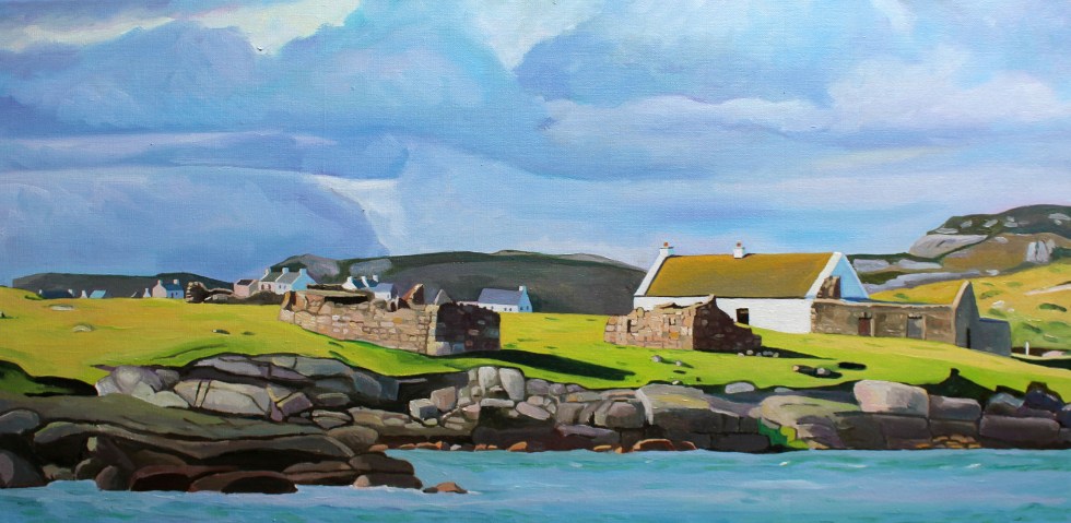
The houses are close but not that close. All of their front doors face southwards, towards the mainland. Mount Errigal and Muckish are off in the distance. I didn’t realise that you could see Muckish this far south. I suppose I have had never been here on such a clear day before.

Gola - View Towards the South West
Gola – View Towards the South West

I tried to take a photo of two camera-shy woolly donkeys in a field. They took exception to my presence and brayed very loudly at me. I got the message and left them in peace. Even the sheep eye you up, they are not used to strangers. They seem to look at you as if they are saying “You are not our farmer, what are you doing here?”.

Donkeys on Gola
Donkeys on Gola – No photos please!
Port an Chruinn
Port an Chruinn
Cottage to Let
Cottage to Let

Gola 2

Houses facing the mainland

On they way back to the boat we pass the infomation centre – an Teach Beag – its a large shed with tables outside. We are hot and I fancy a cup of tea. I try out the one bit of Irish I know on the man behind the counter “Dia duit” (“Hello”) I say. He then says something back to me which I dont understand. That stumps me. Turns out that he just said “Hello” back to me (“Dia is Muire duit”). I need to get a few more phrases/word in Irish under my belt!

This is Paddy Joe, who is 73 years old and still volunteers for the local lifeboat (training and teaching younger volunteers). It is noticeable how fit and active people in Donegal are, especially the men. We talk in English. I love listening to his accent, Irish is his first language. It’s musical. Part Ulster accent, part something else, something almost Scandinavian.  Certainly, of the north. It sort of reminds me of the halting accents of Welsh-speaking farmers in North-Wales, as they seem to trip over their words as they think the right word in English.

Paddy Joe tells a story of going fishing down the Kerry coast and stopping in a pub for a drink. There are Irish speakers there but they do not understand the Irish speakers from Donegal, and the Donegal Irish speakers do not understand them either! I know that its similar in Wales, where Welsh speakers from the North use many different words from those in the West or South.

Some of the few trees on Gola

We decide to catch the 2 o’clock boat back as we have eaten all our sandwiches and the next boat is at 6pm. There is plenty more island to explore on another visit. We haven’t seen the sea arch at Scoilt Ui Dhúgáin, the lake Loch Mhachaire n nGall.

Clear Seas off Gola
Clear Seas off Gola (Bloody Foreland in the distance)

The boat is setting off,  when Sabba spots two girls who came across with us at 11am. He returns to shore to pick them up. They get on the boat looking very relieved. They clearly didn’t fancy waiting until 6pm for the last boat back. The sky is starting to cloud over as we cross and by the time we reach Magheragallon Pier it is overcast.

Donegal painting Gola
A House on Gola SOLD

Read more about Gola Island here

Posted on 19 Comments

Donegal Islands: Gola

Paintings of Donegal, Gola, by emma Cownie

My husband, Seamas, loves islands.  He’s not alone, many people dream of living on or even owning their own private island.  I just love looking at them and painting them.  Which is handy, as the coastline of West Donegal is completely smothered with them.  Looking out from the coast of Donegal, one of the longest in the country at more than  800 miles, is a bit like looking at the night sky and trying to name as many of the brightest stars as you can. Seamas seems to know most of their names without having to look at a map.

Map of West Donegal
The larger Islands of the Coast of West Donegal

Around the coastline of the island of Ireland, there are 365 small islands, and a good number of those lie off the coast of Donegal. Wikipedia has individual pages for 20 of them, but there are many more than that. I can’t find an exact number. Many islands near the coast are little more than rocks big enough for some seaweed to cling to the edges of, visible only at low tide.  Maybe these are just baby islands, islets. How big does a piece of land surrounded by water have to be to be an island, I wonder? If it’s big enough for some grass and a cow it must definitely be an island. There are quite a lot of those near Burtonport.  The cows are well known for swimming between the island in search of better grass. I  kid you not, it’s common off the coast of Inishcoo – click here for more evidence. I think the association between cows and island grazing is an ancient one as several islands take their names from cows, such as inishbofin (Inis Bó Finne) means island of the white cow and Calf island near Aran Island.

There are also about 100 sea stacks.  Are these thin, vertical towers of rocks jutting out of the sea proper islands, I wonder? Slighter bigger and desolate are The Stags, or Stag Rocks, also known as The Three Sons of O’Gorra (Na Trí Mic Ó gCorra) which lie someway to the north of Owey island.  Legend says that they were three pagan swimmers who were turned to stone by St. Colmcille the 6th Century missionary, also known as Columba.

Stag Rocks, Donegal
The Stags

Then there are islands that have (or used to have) people living on them. Arranmore is pretty big (8 square miles) and is home to a sizeable community of  about 500 people full-time residents. Some islands are easy to get to, such as Cruit, which has road bridge to the mainland, and Arranmore and Tory which have a daily ferry. There are others that have only summer ferry such as Gola and Owey Islands.

There are a lot of islands with no ferry but can be reached relatively easily by boat or kayak such as Inishsirrer, Inishmeane, Edernish, Rutland, Eighter, Inishillintry, Inishinny, and Bo, Go and Allagh, Inishmeane, Inishdooey, Insihbeg, Inishfree Lower but are close-ish to the mainland, and  others that are pretty remote, even to people with their own boats such as Umfin, Tororragaun and Raithlin O’Birne and then finally there are the very remote ones are Stags Rocks mentioned above and Roan Inish. Some like Arranmore and Tory are inhabited all year round, others like Owey and Gola are mostly home to people during the summer months.

Painting of Donegal
From Cruit Island

I love the descriptive names of the islands thus Cruit (An Chruit)  means harp-shaped, Owey (Uaigh) means cave as there’s one under the island, Island Roy (Oileán Ruaidh) means Red Island, Inisheeney (Inis éanaigh), bird island and Tory Island, (Toraigh) means High Tower and when you see photos of the island you understand why that is a good description of the island.

Donegal island
Tory Island from the mainland

I have driven across the little bridge to long Cruit Island and I have boldly reversed my car onto the ferry to Arranmore and back again. I have spent a fair bit of time standing on the shore looking across the water at islands, Owey is a good example of this.

Donegal painting
Owey Island
Painting of Donegal Island, Owey
Over to Owey

My latest subject for this mainland-based island-gazing is Gola. Its name sounds vaguely sporting, forever muddled in my mind with football and trainers probably because I used to have a pair of Gola gazelle trainers back in the 1990s. The island has nothing to do with trainers or goals. The name Gola, or Gabhla in Irish, means “forked”. If you look at a map of the island the name makes sense. The fork is the split in the west face of the island.

Gola, West Donegal
Map of Gola Island

We set off on a sparkling afternoon in early April. The sun is out but it’s cold, with a chilly wind. I’d wear my big wooly hat in the car but the bobble on top is too big and it hits the headlining. So I drive without it on. In order to get to a good look at Gola, we drove past Donegal’s tiny airport at Carrickfinn, along a long single track road. There’s a lovely view of Mount Errigal off in the distance. 

Donegal airport

Mount Errigal
Errigal from Carrickfinn

The track then rises and winds its way past a series of isolated houses, both and old and modern. The road is a bit threadbare in places, in good condition in others.

We follow the road until we reach a fine modern house overlooking what I’d call a beach, but this sort of long stretch of curving sand is known as a strand in Ireland. I think this is Dunmore Strand (An Tra Bhan). We climb out the car (I leave my window open in my excitement), with hat and gloves on and various cameras slung around our necks and stuffed in jacket pockets. The tide is out so that I don’t realize that the long stretch of dunes reaching to the north of me, is actually part of a tidal island, Inishinny.

Towards Bunbeg
Dunmore Strand

The blond sand is strewn with majestic pink granite boulders and rocks. The clear sea is a most beautiful violet and turquoise. I have never seen anything quite like it. We spent a lot of time staring at the water, trying to fix its colour in our memories. The seaweed resting in between cracks in the rocks is a fantastic livid green.

IMG_1061
Woolly hat back on, taking photos of Gweedore and Bloody Foreland

Beyond the dunes is in the distance to the east is Gweedore and the village of Bunbeg and Magheraclogher beach. The terrain is peppered with lots of little white houses, most of them modern. In the opposite direction to the east is a very different landscape.

Gola West Donegal
View towards Gola

We have to walk along the sheltered beach and climb across a series of massive rocks to get a better look at the island. The island of Gola seems tantalizingly close, it’s only about half a mile. We can see the ruins of many houses, but also many painted white and with good roofs.

Donegal Island, Gola
Houses on the south side of Gola Island

Seamas was very excited to see the island, as there is a possibility that his Donegal Coll forebears may have lived on the island. However, although we know his paternal grandmother originally from the Gaeltacht (Irish speaking area) somewhere in Gweedore, we cannot track her down in the records. There are lots of possibilities but no certainties.

Gola, is a small, very rocky and rather exposed-looking island. Mind you, I was looking at it from across the water, and it is consistently described as “beautiful” by visitors. The silvery quality of the light on the white-washed building nearest the shore certainly caught my eye. I tried to convey the quality of the light in my first painting of the island.

donegal painting of Gola, West Donegal.
Spring Light on Gola (80x40cm)

We then clamber across another set of massive pink granite rocks to the headland nearest the island. It is more exposed here. You can get a better look at the houses. I am fascinated by the ribbon of little white-washed houses that look out towards the mainland. They look they were positioned with the prevailing wind (blocked by the hill to the west of them) and company in mind. There is a larger modern house set back from the old cottages.

I wonder whether that belongs to one of the few full-time residents that live on the island. My second painting of Gola, I think give you a sense of just how rocky the island is. The hills and fields are peppered with boulders, rocks and stone walls. The coastline along the south side of the island is a rampart of geometric rocks. No wonder the little harbour is tucked in on the sheltered eastern side of the island.  

Donegal painting of Gola
Oileán Ghabhla (80x 40cm)SOLD

The island is pretty small. It covers about one square mile (500 acres). Although it seems quite flat in comparison with Aranmore, it is “mildly hilly” on its west side, rising to 238 feet at Cnoc an Choillín and 212 feet at An Mhaol Mhór. These hills provided vital shelter for the houses that stretch along the east side. (Images taken from Google Streetview).

On the other side of the island is as statuesque sea-arch.

Donegal Sea Arch
Sea Arch, Gola Island, Donegal

Gola was once inhabited by a surprisingly large community of over 200 souls. I looked across at this barren-looking land and wondered how on earth they could grow enough food to survive. Mind you, the land is not as bleak as the tiny fields of west Galway, full of stones. Yet survive they did, thrive even. Vegetables could be grown on the land fertilised with seaweed and turf could be cut from the bog to heat the homes. Many of islanders were fishermen and they would also travel to Scotland for seasonal to work each summer to supplement what they could grow on their small farms. Surprisingly, up until 1920s, the island population continued to grow, but it declined after 1930 and then became deserted in the late 1960s

Yet, the island was never completely abandoned. Families would come and spend summer months here. Although most of the buildings on the island are derelict, many have been renovated by Gola families as holiday homes.  The island now has mains electricity and water supply and a small number of people live on the island all year round.

Being an island the sea sustained island life but it also curtailed it. Bad weather could cut the island off from the mainland, especially in winter. The coast of Donegal frequently faces some very severe weather from the prevailing westerlies and the heaving Atlantic Ocean. Gola was immortalised in the sad lament “Baidin Fheilmidh” (Feilim’s little boat), a song about a Feilim’s bat which sets off for Gola and then Tory but was crushed against Tory island, sinking with poor Feilim in it. There are various versions of this song you can listen online including one by Sinead O’Connor but I think I like this paired back version best, which also has the lyrics in Irish & an English translation here.

There is a ferry service that runs from Bunbeg from June to September. Sabba, the ferryman, also runs facebook page under the name “Gola Ferry Service” and it it is a good idea to check before planning a visit.

Ferry to Gola Donegal
Gola Ferry Service Facebook Page

We were too early in the year, sadly,  to visit by boat. I am pretty sure that Seamas and I will be making a trip to Gola island in July when we are planning to be back in Donegal. We returned home to Burtonport for tea and biscuits to warm up in front of the fire.

IMG_1119
Seamas and Mitzy in front of Gola Island.

Posted on 24 Comments

All hands to the Pumps

Blog about gorse fires

When I decided to write this article I was not entirely sure I should. On Easter Monday I was gripped by the unfolding story of a massive, dangerous gorse fire spreading across the Rosses, a part of West Donegal. It worried that it would get completely out of hand and burn down people’s homes and destroy their livelihoods. I was checking twitter and my newsfeed for news of what was happening on an hourly basis to see if the fire had been brought under control. I was also worried about our own house in the Rosses. I love the area very much and feel attached to it. Yet, I felt guilty of being an outsider, what my husband calls a “Sasanach” (Saxon) or a “blow in” to the area only concerned about my house when brave local people were fighting desperately to quell the fires and save their homes. Actually, I was full of admiration for the community spirit and sheer grit and determination of the local people to fight the fire and save each other’s homes. 

Donegal is often called the “forgotten county” on account of the belief that it is ignored by the government of Ireland, even in times of crisis. Maybe it’s because it’s so far away from the capital Dublin, or because of its location on the border with “troubled” Northern Ireland. On Monday that perception seemed to be borne out by events.

Painting of village in West Donegal
Over to Kinclassagh SOLD

It had been an unseasonably warm Easter weekend. It was the warmest for 70 years. This followed on from the warmest Irish winter on record, that was also drier than average. Unfortunately, this has dried out the moorlands in many parts of Ireland. In recent weeks there have been many fires over moorland in Ireland and the UK; Limerick, Kerry, Down, and across 700 acres of Yorkshire. Moorlands (and in Ireland the boglands) are “usually” by their very nature wet and soggy places but climate change has changed all that; in these drier conditions, (along with the heather and gorse that grow on them) have become tinder-boxes.  Spring and early summer is the most dangerous time of year for gorse fires,  between i.e. March and June, when ground vegetation is dead and dry following the winter period.

The Rosses in West Donegal seems particularly vulnerable to gorse fires breaking out. Gorse is a stubborn plant with thick branches, prickly thorns and vibrant yellow flowers during the spring and summer. It is also highly flammableAt least three gorse fires broke out last week; one near Kinclassagh, one near Crolly and another near Drumnacart, Annagry, which actually destroyed two homes. 

The gorse fire that broke early in the morning on Easter Morning between Loughanure & Annagry was a different order of scary fire. The dry conditions coupled with the ever-present wind whipped it up and it quickly got out of control and spread over a large area threatened many homes. Fires in windy dry conditions will soon leap and fly. Just to complicate things there was a separate fire at Belcruit/Kinclassagh. It has since been claimed that a fire hydrant, in the village was blocked, preventing fire crews and locals from having a readily available water supply to combat the blaze. 

When this fire started 5 fire engines came to try and put it out. By the end of the day, 15 fire engines had come from all over Donegal. One fire engine even came across on the ferry from Arranmore Island. Hundreds of local volunteers also came out to help, many of them were fighting to save their own homes from being destroyed. Trenches were dug, houses were doused with water. It must have been hard, dirty and frightening work. Farmers brought slurry spreaders filled with water to douse the area. Others looked after the people fighting the flames, bringing them bottled water and food. 

Fighting the wildfire in Wst Donegal
Dousing the gorse

One fireman told a local newspaper, the Donegal Daily: “This is unreal stuff. I have battled a lot of gorse fires over the years but this is amongst the most dangerous. “Everything is bone dry and there is a strong wind so these are perfect conditions for the fires to spread rapidly.”

The local authorities and the Pat “The Cope” Gallager, the TD for Donegal, lost no time in asking (at 9.30am) for The Irish Air Corp for helicopters to help fight the fire. For some reason, they were not forthcoming. The Council waited and waited. Then a group of the firefighters fighting the separate fire near Belcruit were trapped by the flames. The area had been doused by water, so they weren’t in immediate danger, but it was a very worrying plight for them to be in. I can’t imagine what that must have been like to be surrounded by flames, like that. 

Donegal County Council decided they could not wait any longer for the Air Corps, and decided to hire a private helicopter to fight the fire. It took 7 hours before the Air Corps finally arrived from Dublin on the scene at 5pm and proceeded to scoop up 42,000 litres of water from the nearby sea and lakes and drop them on the fire. They seemed to have made all the difference. 

The Firemen at Belcruit escaped the flames when water was dropped on the fire, clearing a safe path for them. It must be a very difficult job aiming the bucket at the fire but from the video clip here, you can see the Air Corps are very good at it.

I got quite a shock when I saw the photo of Kinclassaagh below on twitter. It is a village I have painted a few times. You may be able to pick out the blue house to the left of the photograph below, which is in the centre of my painting “In the Shadow of Errigal”. The houses in the village are presumably being in doused in water in preparation of the worst-case scenario.  

Fortunately, by the evening the fire was eventually brought under control and no new fires have broken out. The images of the aftermath are shocking. So many houses are surrounded by blackened gorse. They were clearly very close to being destroyed. It must have been the stuff of nightmares for the people who lived in them.

The fire will have been devastating for local wildlife and bird populations, their chicks and nests were not saved.  This is the sort of event that Birdwatch Ireland calls “carnage in our mountains and hills, yet silence from our Government”. Rare plants whose precious seedlings have just emerged are also scorched along with hares, badgers, lizards, frogs, mice and all sorts of beetles.

Gorse Fires West Donegal 2019
The aftermath of the gorse fires
West Donegal Gorse fires
The extent of the fire


When I first heard of these terrible wildfires, I assumed that it was due to climate change and global warming. Yet, when I did a bit of research, I found that it was a bit more complicated than that. Yes, dry winters and summers are factors but it seems that there are other reasons that have contributed to this issue, not only in Ireland but in the British Isles as a whole. So it seemed to me that these issues need to be dealt with more urgently than they have been so far. For all our sakes. Tackling the problem of the gorse fires could actually help with the issue of climate change. 

Most gorse fires are started by humans, although we don’t actually know how Monday’s fires were started, and it seems pretty clear that they were not started by a local farmer.  In many cases, however, it seems that wildfires are started deliberately by landowners, or by arsonists, or even accidentally by tourists’ barbeques (as in the case of the recent fire in Yorkshire).  Northern Irish fire service estimates that in one month in 2017 they dealt with more than 500 fires, of which 466, it believed, were started deliberately.  

Gorse is so difficult to clear, its not uncommon for farmers sometimes burn the land so it can be cleared. It is currently against the law in Ireland to burn land from 28 February to 1st September. This is to protect nesting birds and their young. Paradoxically, part of the problem is that these fires don’t happen often enough. Many Irish hill farms have been abandoned or neglected and regular burning has not taken place, allowing layers of detritus to build upon the ground while gorse and heather have grown leggy, meaning that fires are harder to control. Thus, the rise in the number of gorse fires may have more to do changes in farming practices than climate change, as such.  

In an ideal world, I believe, upland farmers would not be paid to clear land but instead, be paid to grow native trees on their land. Yes, call me a tree-hugging hippy, but by reintroducing trees, shrubs, birds,  insects, and large mammals would have their ancient habitats restored. Ireland needs more trees. The world needs more trees. This is a good way to tackle climate change, instead of cutting down the rain forest at ever increasing rates. More trees also reduce the risk of flooding. A recent study by Bangor University (the one in Wales) found that water was absorbed 67 times faster by native woodland than on grass.  Once 80% of Ireland was covered in trees, now it’s only 10.5%; the lowest in Europe (the average is well over 30%). Of that native trees comprise just 2% of the total! These incredibly low numbers are primarily due to human activity in the 18th and 19th centuries, and to a lesser extent also activities in the early 20th century.

The government does plan to increase Ireland’s tiny forest cover to 18 percent by 2046, under the Strategic Plan for the Development of Forestry,  but unfortunately, the vast majority of new trees are Sitka spruce tree farms. These are non-native trees, planted in crowded, rows, robbing light from the forest floor. They do not encourage wildlife in the way that native trees would. They are barren places. They also need fertilizers and pesticides. They are patently, the wrong trees. The woodland League recently ran an excellent scheme supported by President Michael D Higgins, called “Forest In A Box”, involving 700 children in nine primary schools in Co Dublin, Co Offaly and Co Clare. The “box” in question is a native tree seed box – a metre square – which can provide up to 200 healthy native trees every two years. It would be great if this scheme could be rolled to the whole of the country, maybe there are plans to do so. 

One thing they are not short of in West Donegal is community spirit. On Monday evening, the brave people of West Donegal will come together again, for a massive clean-up operation to collect all the objects like water bottles, spades and face masks that were dropped whilst fighting last week’s fire. Yet again it will be all hands to the pump. It will also be a good opportunity for the brave, hard-working people of Donegal to “debrief” after such a traumatic experience. This fire won’t be forgotten for a long time, but fortunately, no lives were lost. 

Crainn

“Carinn n hEireann – The Trees of Ireland”

(Here’s link to a beautiful Irish language series on Irish trees, it’s well worth watching, because it’s atmospheric, poetic and informative. Click the “CC” logo on the bottom right of the screen for English subtitles )