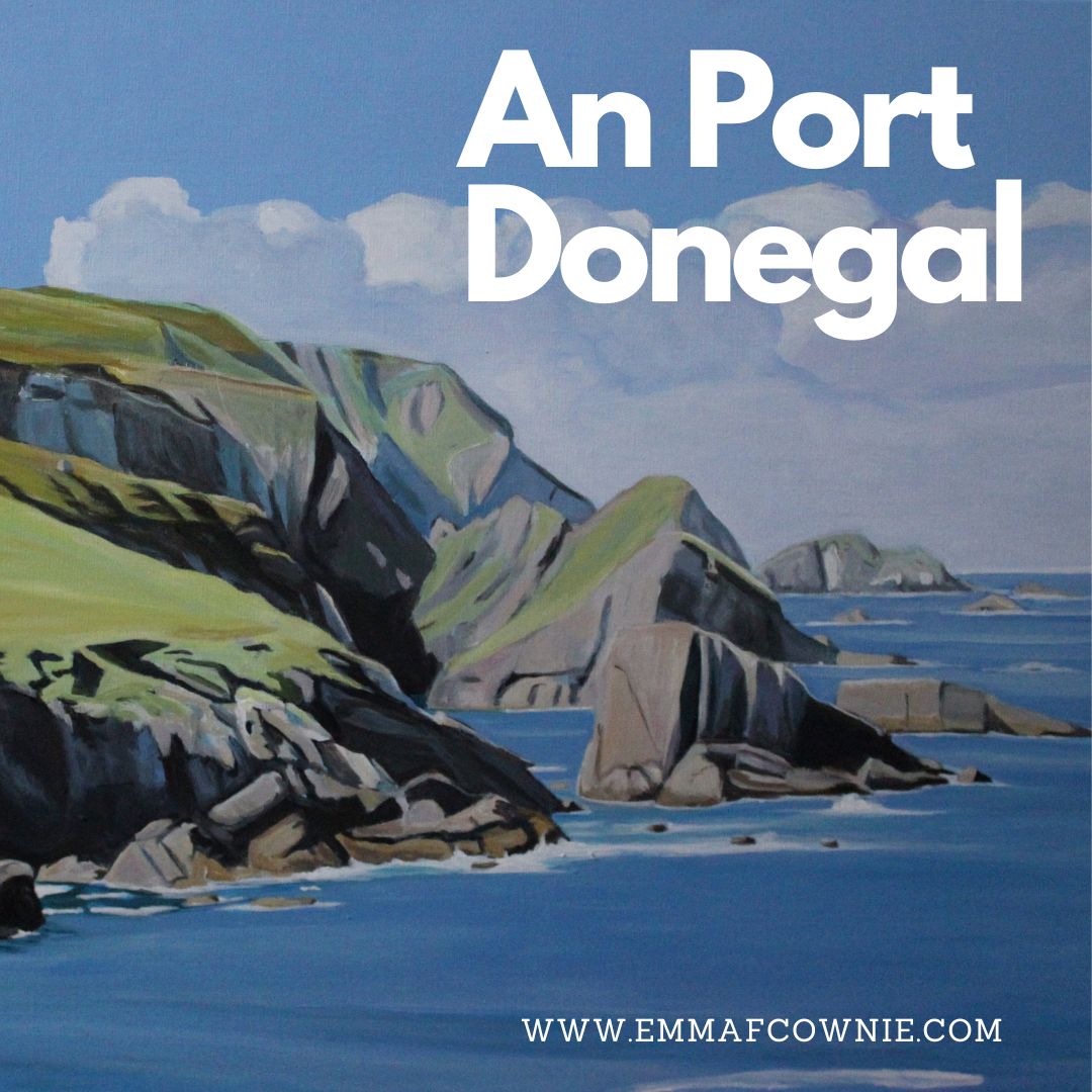
An Port has loomed large in my imagination for a long time. It’s very remote and quite difficult to get to. To reach it, you have to drive down a very, very long single track road (it’s about three miles but it feels longer) on the way to Glencolmcille. There are plenty of sheep and only a few people.
The Road to Port
At An Port there is a small quay and a tiny deserted fishing village which looks out over a small bay, surrounded by cliffs and truly massive slabs of rocks and sea stacks. Its one of those landscapes that you imagine can be found all along the west coast of Ireland but is actually unique. When I visited Texas in the late 1990s I thought it would all look like Monument Valley, thanks to those John Ford films. I was surpised to find it was pretty flat.
An Port, Donegal – photo credit Emma CownieAn Port: Photo credit Emma Cownie
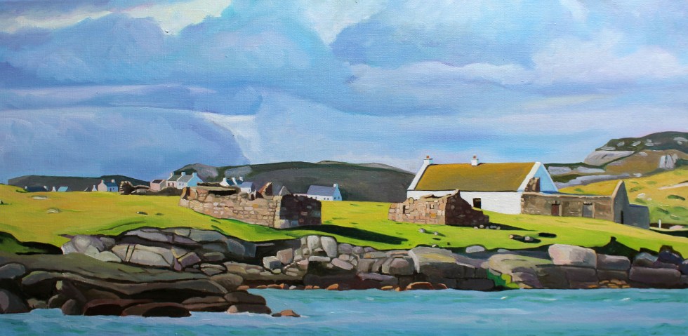
The village was still inhabited in the 1920s. The hillside is littered with the remains of the stone houses
Remains of houses at An Port: Photo credit Emma Cownie
There is one inhabited house, now an AirBnB property. You can see it on the hill behind me in the photo my husband took of me (below). This was Annie McGinley’s family home.
Me at An Port
I first heard about Port in 2018 from a TV programme about the famous American landscape artist Rockwell Kent and his stay in Donegal the 1920s. Rockwell Kent is probably best known today for his illustrations for Moby Dick.
Moby Dick Illustrated by Rockwell Kent
Unfortunately Kevin Magee’s film (in Irish with subtitles) “Ar Lorg Annie” or “Searching for Annie” is no longer available but you can see a short clip on Youtube here. A friend of Kent’s, Rex Stout, had funded his trip to Ireland. He paid him $300 a month on the condition that he had the choice of two painting when he got back. This is one of them in California, “Prince Charles’ Cove”.
Rockwell Kent and his second wife Frances Lee Higgins (they were on honeymoon) spent several months in the near by valley of Glenlough on a farm belonging to farmer Dan Ward. Kent stored many of his paintings back at Port, in the home of Annie McGinley, who modeled for him. Her she is.
The original “Annie McGinley” now rests in a private collection in New York,
Rockwell Kent returned to Donegal, 32 years later. He had wanted to buy Dan Ward’s farm but it had already sold to another farmer. Instead he sought out ‘this singularly lovely teenage girl with whom I had danced many a jig’ and found her in nearby Crobane, married, midddle-aged and ‘broad-beamed’. She had had 14 children, 12 had lived.
Annie McGinley and Rockwell Kent in 1958
Rockwell went to find Annie’s long abandoned cottage in An Port where in 1926 he had dried his Donegal paintings. It turned out to be the only structure still standing, barely supporting the weight of an overgrown thatched roof, a year or two from dereliction. ‘This house, we thought, we ought to buy and fix and have as a place to come every year …’ but he didn’t.
If you look on the left hand side of my painting “An Port” (below), you will see tiny fence posts along top of the cliff. They help give a sense of scale of the huge cliffs and rocks. I can’t remember who first described this landscape it as the “land of giants”but it truly apt.
It is hard to do justice to this incredible landscape but I think that Rockwell Kent’s paintings do. He really capures the majesty and warm colours of Donegal. He also excels at Donegal skies and light. I am really in awe of him.
I wish I could see the original paintings but this is very unlikely. It seems that none of Rockwell Kent’s large paintings stayed in Ireland. Most of them are either in the USA or in Russia. But that’s another story.
Our visit to the island of Inishbofin last month was one of those rare “perfect” days in life. The weather was warm and sunny with enough of a sea breeze to blow away any viruses. We have been looking and admiring from afar the tiny, remote island of Inishbofin, off the coast of Donegal, for quite a while now.
Location of Inishbofin, Donegal
Inishbofin, Donegal
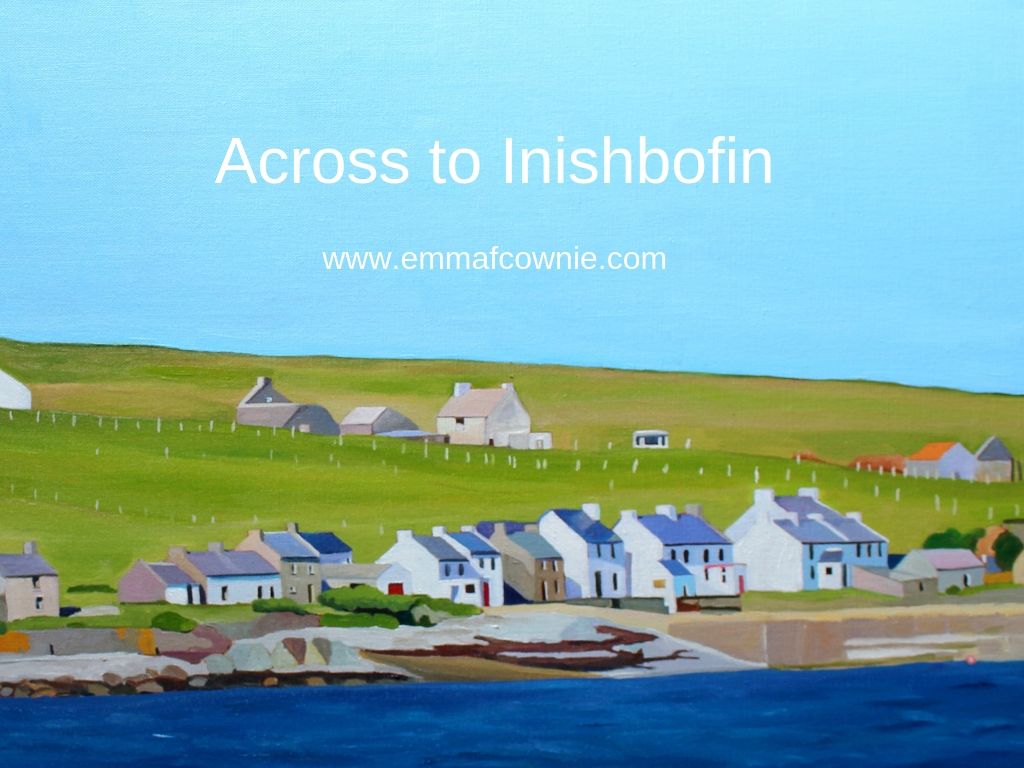
It is 3km/2miles from the pier at Machaire Uí Rabhartaigh / Magheraroarty but that didn’t stop me painting the shoreline of the island a couple of years ago. I also wrote about the island (here) long before I ever got the chance to visit it.
Across to Inishbofin SOLD
Storm Over Inishbofin SOLD
Emma Cownie
It is very easy to confuse the Donegal island with the more southerly Inishbofin near Galway on the internet as google likes to show you maps and ferry pages for the Galway island, even if you type in “Ferry times inishbofin, Donegal”. I think this must because a regular ferry service in Donegal was only started this summer by Harry Coll and his brother, Owenie. Harry has recently retired from his life as a fisherman in Killybegs, Donegal, and decided to buy a boat called Saoirse na Mara II ( which translates, I think, as “Freedom of the Sea II”) in order to run a daily ferry service to the island. As far as I can tell, they have not received any government funding to help them in their venture.
Inishbofin Ferry
You will notice that the flyer for the ferry is in Irish and English. This is an Irish speaking area of Ireland, the Gaelteacht. This was the first place I heard Irish spoken this year, in fact. Inishbofin is an Irish-speaking community and it was a real pleasure to hear people speaking Irish/Gaeilge, although I could only pick out the odd word as I only have a very basic understanding of the language. We were told by the islanders that “Inishbofin” is actually pronouced “Inish-bofin-yeay”. You can here that pronunciation in this Irish-language video here.
The name Inis Bó Finne means “island of the white cow” in English. The white cow, Glas Gaibhnenn, was owned by a blacksmith on the mainland but was stolen by Balor, the mythical one-eyed King of neighbouring Tory Island and hidden on Insishbofin. This wasn’t any old cow, it was a magical cow. It had huge teats that never ran dry which produced an unending supply of milk. Obviously, such production required a great deal of fuel and in no time the cow ate all the grass on the island and had to move on elsewhere. The island is tiny, a mere 2km long and 1km wide or about half a square mile/300 acres so I could well believe that the Bó Finne ate all the grass pretty quickly. Yet, although it looks tiny from the mainland yet it doesn’t feel that tiny when you are on the island.
Saoirse na Mara II at the Magheroarty Pier (Inishbofin is in the distance)
The first inhabitants are believed to have been of Scandinavian origin, who arrived at the time of the Viking raids on Ireland’s coast in the C9th and C10th. Their descendants are thought to have been exterminated by Cromwellian soldiers in the mid-C17th. I wondered whether they had all been killed as I noticed that all the islanders had blue eyes, possibly suggestive of Scandinavian genes. Subsequently the island was settled by mainlanders from Donegal escaping oppression, poverty and famine. We met one islander who jokingly said his family had “recently” moved to the island, in the 1840s.
Map of Inishbofin
It is said that the islands potatoes, like those of neighbouring Tory Island were unaffected by the potato blight which destroyed the main food source of Ireland’s peasantry in the mid-C19th. The blight, and other factors (such as criminal mismanagement of resources by the British Government) led to An Gorta Mór or “The Great Hunger“; starvation and famine fever which led to over a million deaths and mass emigration.
Approaching Inishbofin
As recently as the 1960s, a population of roughly 120 islanders enjoyed a tranquil, if tough, existence, fishing and farming. Nowadays, only a few islanders spend all year on the island, farming on a part-time basis. Many of the houses on the island have been renovated, mostly for use as holiday homes. From March to October many of the former inhabitants return to fish for lobster, crab and Atlantic salmon, or to gather shellfish and pick edible seaweeds such as cairrigin (carrageen) and creathnach (dulse) from the rocks. Other families move back for the school holiday in the summer months. The new ferry service has made visiting the island even easier for families and day trippers.
Irish moss or carrageen moss (Irish carraigín, “little rock” from wikipedia
The morning we visited the island there were lots of people waiting at the Magheraroarty Pier for the ferry and the Coll brothers made several trips to bring them all over to the island. The trip only took ten minutes and the sea was smooth. Stepping off the ferry we were transported to a tranquil and calm world. All the time I was on the island I saw one car and heard only birdsong and the wind. It was bliss.
The Pier at Inishbofin
Inishbofiners working on a roof
Drying in the sun
Muckish Mountain on the Horizon
The island has two halves connected by a narrow, sandy col. There are two villages on the island, one near the harbour of An Clachan (Cloghan), and the other a short distance away at An Garradh Ban, also known as East Town.
The southern half of the island is fertile and was cultivated in the past in the traditional “clachan and rundale” manner, involving communal usage of scarce arable soil and cattle pasture. The ancient field boundaries are still in place, though the fields have now reverted to grassland, providing essential habitat for geese and especially corncrakes – flourishing here, unlike in the rest of the country.
Corncrake
Aerial View of Inishbofin (from BoffinFerryDonegal.com facebook page)
The islanders are very friendly and several people stopped to chat to us to tell us about the island. They have a reputation for speaking to visitors (preferably in Irish Gaelic, but in English too) and like telling stories about the island and its history. One of the islanders, Daniel, mentioned the mystery of the missing millionaire. In 1933 Arthur Kingsley Porter, a professor of Fine Arts at Harvard University, bought Glenveagh Castle in the heart of the Derryveagh Mountains and made it his home. He also built a house on Inishbofin which he used for weekend breaks with his wife. On the morning of 8th July 1933 Kingsley Porter disappeared after going for a walk the morning after a massive storm, and was never seen again.
Arthur Kingsley Porter
Conspiracy theories abound. Had he accidentally fallen from a cliff or had he taken his own life? Had Arthur been murdered? Or had he faked his own death and re-emerged with a new identity on mainland Europe? All of these are a possibility, as Arthur was gay at a time when it was illegal and regarded as deeply shameful (50 states criminalized same-sex sexual activity until 1962). To make things worse, Harvard, Arthur’s employer was running an anti-gay campaign. The college held a secret court to expose and expel gay students and faculty. Two students, accused of being gay, had already died by suicide. Arthur was fearful his homosexuality would be revealed and there would be a scandal. So here we have a possible motive for suicide.
Lucy and Arthur
At the inquest – the first to be held in Ireland without a body – his widow, Lucy, told of her frantic six-hour search with local fishermen. “I think my husband must have slipped off the cliffs, fallen into the sea and been carried away,” she said. Some of the islanders thought that his wife might have done away with him. Yet at the same time there were rumours of a boat that had been seen near the island at the time of his disappearance. If anyone had the money to start a new life in a new country it was Arthur, and Arthur knew Paris with its gay nightlife well as he had studied there as a student in 1923. I suspect however, that if he had started a new life in Paris, he would have eventually been recognised by one of the many American emigrées who also lived there.
Boats on Inishbofin
Anchorage on Inishboffin is too exposed to leave boats afloat and so they are pulled up onto the foreshore.
Inishbofin has witnessed a number of maritime tragedies. In 1929 an island fishing boat was cut in half by a steamer in thick fog off Bloody Foreland, and all but one man drowned. Another boat was swamped in 1931 in the “keelie”, the sound between Inishboffin and InishDooey. During the Second World War, in December 1940, a Dutch ship by the name of Stolwiik broke down after leaving a covoy in a westerly gale. The Arranmore lifeboat made truly heroic rescue of the crew. Read more about it here.
The old phone box – once the island’s only phone
The island has a stunning coastline and a view that include Mount Errigal, the Seven Sisters and seascapes stretching from Cnoc Fola to Tory Island.
I will end with some a film and some paintings of Inishbofin by the very talented artist Cathal McGinley. His paintings were on exhibition in the parish hall on the island – my photos aren’t great but I hope you get a sense of the intense colours and energy of the paintings. Cathal chatted to us outside his beautiful cottage for over an hour and kindly gave us a cup of tea and a bag of carrigeen.
It was quite a shock getting off the ferry at the busy pier at Magheroarty after the incredible peace of the island. We will be back.
The journey only takes 10 minures (weather permitting)
To book the ferry from Magheroarty Pier to Inishboffin Island:
– Telephone Harry on 087 4345892
– Text – Whatsapp – Viber message to 087 4345892
– Email on: boffinferrydonegal@gmail.com
– Social media (facebook / Instagram) www.boffinferrydonegal.com
Gola is a Donegal island I painted and thought about long before I set foot on its shores. I have written about it beforehere.Last month I was fortunate to visit it. The wind had woken me in the night. The early dawn had me awake by 6.30. I felt so tired and my limbs ached that I drank the last can of caffeinated energy drink that was sitting in our fridge (leftover from the epic drive up north).
We drove the 40-minute drive from Burtonport to the little harbour at from Magheragallon Pier, Bunbeg. The final part of our drive was along single-track road across flat grasslands which were home to both a graveyard and a golf course. That sounds grim but there’s plenty of space for both here.
View of Gweedore from Magheragallon (Machaire Gathlán)
It was the most perfect of days. The sun was shining, the sea was sparkling and flat and the sky was a hazy light blue. The sand was very light, but not white. The sea was incredibly clear and on a clear day like this, you could easily see the seabed, giving the sea a beautiful turquoise colour.
“The Cricket” at Magheragallon Pier (Machaire Gathlán)
The pier is well set up for waiting travelers with benches and a portaloo. We sat on a bench and waited for Sabba the boatman to give to signal to get on board. Seamas, my husband, tells me that Sabba the boatman has been sailing since aged 7. He has a facebook page herewhere he will post times of sailings and photos.
Fisherman off Gola
It’s only a 15 minutes crossing. As soon as we set foot on the island, I am struck by the sense of peace here. Most of the sounds you are of nature. Birds singing. Sheep bleating. The wind. That’s it.
Gola Pier
This is because there are very few motor vehicles here, one or two cars and some tractors.
A fine red tractor
Gola is in the Donegal Gaeltacht, where many people speak Irish. They are brought up speaking Irish at home and in school. So the signs are in Irish. Some have English translations, but not all did.
In 1911 as many as 169 people lived here but in the 1960s people started leaving as jobs and a better standard of living on the mainland and abroad had a stronger appeal than full-time life on the island. Only a handful of people live here all year round now.
Gola is part of the Gaeltacht
It’s so peaceful. The land is covered vast stretches of long yellow prairie-like grass spotted with rocks and a few sheep and their sturdy lambs. The houses are scattered across the island along tracks.
Boat for Sale on Gola
Some of the houses are modern, others have been renovated and are still lived in during the summer months at least, others are boarded up but many lie ruined, without roofs or reduced to crumbling walls.
Houses on GolaHouses on Gola
It was interesting to see the houses on Gola close up after looking across the water at them from Dunmore strand (see painting below). The houses are spaced much further apart than I supposed them to be. I was not satisfied until I had walked all the way to the southern tip of the island, so I could turn and look back at the houses. In this way, I could make sense of what I saw in early spring.
Spring Light on Gola
The houses are close but not that close. All of their front doors face southwards, towards the mainland. Mount Errigal and Muckish are off in the distance. I didn’t realise that you could see Muckish this far south. I suppose I have had never been here on such a clear day before.
Gola – View Towards the South West
I tried to take a photo of two camera-shy woolly donkeys in a field. They took exception to my presence and brayed very loudly at me. I got the message and left them in peace. Even the sheep eye you up, they are not used to strangers. They seem to look at you as if they are saying “You are not our farmer, what are you doing here?”.
Donkeys on Gola – No photos please!Port an ChruinnCottage to Let
Houses facing the mainland
On they way back to the boat we pass the infomation centre – an Teach Beag – its a large shed with tables outside. We are hot and I fancy a cup of tea. I try out the one bit of Irish I know on the man behind the counter “Dia duit” (“Hello”) I say. He then says something back to me which I dont understand. That stumps me. Turns out that he just said “Hello” back to me (“Dia is Muire duit”). I need to get a few more phrases/word in Irish under my belt!
This is Paddy Joe, who is 73 years old and still volunteers for the local lifeboat (training and teaching younger volunteers). It is noticeable how fit and active people in Donegal are, especially the men. We talk in English. I love listening to his accent, Irish is his first language. It’s musical. Part Ulster accent, part something else, something almost Scandinavian. Certainly, of the north. It sort of reminds me of the halting accents of Welsh-speaking farmers in North-Wales, as they seem to trip over their words as they think the right word in English.
Paddy Joe tells a story of going fishing down the Kerry coast and stopping in a pub for a drink. There are Irish speakers there but they do not understand the Irish speakers from Donegal, and the Donegal Irish speakers do not understand them either! I know that its similar in Wales, where Welsh speakers from the North use many different words from those in the West or South.
Some of the few trees on Gola
We decide to catch the 2 o’clock boat back as we have eaten all our sandwiches and the next boat is at 6pm. There is plenty more island to explore on another visit. We haven’t seen the sea arch at Scoilt Ui Dhúgáin, the lake Loch Mhachaire n nGall.
Clear Seas off Gola (Bloody Foreland in the distance)
The boat is setting off, when Sabba spots two girls who came across with us at 11am. He returns to shore to pick them up. They get on the boat looking very relieved. They clearly didn’t fancy waiting until 6pm for the last boat back. The sky is starting to cloud over as we cross and by the time we reach Magheragallon Pier it is overcast.
Inishbofin, Inis Bó Finne in Irish, means Island of the White Cow. There are two different islands off the coast of Ireland bearing this poetic name. The name suggests the importance of cows in early Irish society. This is not surprising at all as cows have been vital in many ancient human societies. The “other” Inishbofin is off the coast of County Galway further down south. The one I have painted is off the coast of Donegal, near Machaire Uí Rabhartaigh (Magheraroarty).
It was a chilly, sparkling day when we visited in late spring. We walked along the quay at Magheraroarty and watched a The Queen of Aran ferry come in and pick up some passengers for Tory Island 9 miles to the north.
Ferry at Magheraroarty Quay
Queen of Aran Ferry at Magheraroarty
Queen of AranMap of Donegal Islands
Much closer than Tory Island is Inishbofin. It’s a mere 3km (1.8 miles) from the mainland. I took photos of the houses on the island with my zoom lens. They were still very small.
Inishbofin, Donegal
I originally wanted to paint this whole stretch of the island’s coastline but I realised that without a more dramatic (cloudy) sky, most of the canvas would end up being a lot of light blue and a tiny strip of land at the bottom of the painting. So I chose a section of the coastline and focused on the details of the houses that I could make out.
I get a lot of pleasure from looking at the clean lines of the old houses – I also enjoy a landscape with no cars. If you have eagle eyes you will spot a solitary caravan on the hill above the main street on Inishbofin. The island is approximately 1.2km wide and 2km long with a small seasonal population of about 50 people, who are Irish-speakers. I believe, a few hardy souls live there all year round.
Here’s a lovely video about the people who live on the island in the summer months. It’s in Irish (as they are Irish-speakers) but there are subtitles.
I get very attached to my Donegal island paintings. I’m not sure why. Maybe its because I get such pleasure at looking at those unmodernized houses. I like the length of the image too. Perhaps it because, so far, I have looked across the sea at them and had to reconstruct the landscape with care.
Across to Inishbofin (detail)
It’s hard to explain, but it’s like my mind has “felt” the shape of the land, the rise and fall of the shingle beaches, the spread of seaweed on the shore, the rocks and hills behind the houses. It’s usually my paintings of animals that find it hard to part with!
Across to Inishbofin SOLDInish Bofin beach
That house with a red front door on the right side of the painting is for sale.
Teach Johnny, Inishbofin Island
Many of the islands have seasonal boats. We are planning to visit one or two of these island in the next few weeks when we are back in Donegal. My list of islands to visit include:- Gola, Inishbofin, Tory and Owey. I don’t think we will manage more than two of those this visit. It depends on the weather and energy levels.
Here are my other Donegal island paintings (I have parted with two of these).
Spring Light on Gola – Seamas’s favourite painting!