Donegal is a big mountaneous county in a big country. Imagine my shock when I discover that it’s only the 4th largest in Ireland (after Cork, Galway and Mayo) at 4,860 km2 (1,880 sq miles). It seems even bigger as there is no railway or motorways here, so it takes a long time to travel around all the mountains. One of joys of the county is that it’s relatively empty (the 5th least populated in Ireland) with 32.6 people per km2.
There is also a lot of coastline and the landscape varies from remote mountain bogland, rocky shores to lush rolling farmland in the east. Here are three small paintings I have completed recently that reflect some of this diversity.
The first painting is the furthest north – Malin on the Inishowen Peninsula. This peninsula is the furthest north in Ireland – Malin Head is represented by the red star nearest the top of the map above. It is further north than any part of Northern Ireland! This causes a lot of confusion for my parents who have never been to Ireland despite the fact that my father’s grandparents were from Cork.
The wee House at Malin is a cave, where folklore has it that no matter how many people enter it will hold all. It predates a monastic foundation and Holy Well. The cave and holy well were originally associated with the belief in the sanctity of water and local tradition states that the original foundation was built to exorcise evil from the area. The “Saint” venerated was St. Muirdhealach. He supposedly blessed the well (located in a cavern underneath the large rock directly in front of the ruins of the church).
The second is a view from Arranmore, the largest of the many islands off the coast of Donegal. This is represented by the red star furthest to the left/west on the map above.
And finally Muckish Mountain which lies further inland in West Donegal. I notice Muckish isn’t always included in Tourist maps (like the one bolow which has a red triangle for near by Errigal), yet its distinctive flat backed shape can see seen from Arranmore in the far west and even Carrigans in the far East of Donegal.
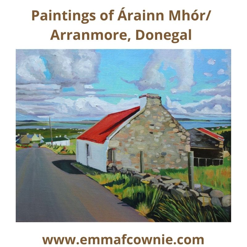
I recently join the Stair Árrain Mhór – Árrain Mhór History Facebook group and was overwhelmed by the positive response I received from the members when I put my most recent post online there. I was asked if I had any more paintings of Arranmore for them to see, so here’s a collection of all my paintings of the Island that I have completed in the last two years.
Where it reads (Private Collection) it means that the painting has been sold. I hope you enjoy looking at them.
Poll na mbadaí (Harbour of the Boats) Arranmore, Ireland.
Here is my latest Donegal painting. I am delighted that it will be going to its new home in California, USA, very soon.
A narrow lane curves down to a shining white cottage and outbuilding and to the right. This is not a public road but a lane to the house, just around the bend. Here it is bathed in glorious winter light. The low sun creates long dark shadows along the lane. The sheep look up, they are not used to strangers (not like the sheep on the Gower that barely give visitors a second glance). On the horizon, you can make out the tiny but distinctive shapes of Muckish and Errigal mountains . You can just make out a line of fence posts that lead down towards the small natural harbour that gives its name to this place: Poll Na Mbadaí or Poolawaddy. The meaning of Poolawaddy (also spelled Pollawaddy) is often disputed. In irish Poll a Mhadaigh, could mean Poll – the harbour, a Mhadaigh – of dogs or Poll na mbadaí, Poll – the harbour, na mbadaí – of the boats. I suspect that the harbour of the boats is more likely, as it is a natural harbour and pier, but I could be wrong. I only have a basic understanding of Irish but I like to try and read it because place names are very descriptive (as they are in Welsh too) and often poetic. A harbour of dogs is just as possible, after all, there are tiny islands nearby named Calf, Duck and Gull Island.
Arranmore Island map
It feels like it has taken me 7 months to get here. The last painting I finished just before I broke my leg in eraly March was also a painting of this area (see below). It has taken me so long to recover my “painting stamina” and gradually paint larger canvases (although some artists would not consider 80×60 cm “large”). I don’t think I will go any larger for now. I feel exhausted after finishing a large painting these days.
View From Poolawaddy (Private collection) painted in early March 2020
I like to understand what it is that I am painting, to get a sense of its history and the people who live/d there. I might call a building an “outhouse” for example but very often that building was once a family home, a newer bigger one having been built next to it. It matters to me to know that. It helps me make sense of a place. I only know only a little about the History of Arranmore, however, so what I have written here has been taken from articles I have found online (I have included links and a list of websites at the end).
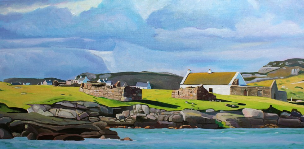
Life on the east side of Arranmore Island, where Pollawaddy is located, is marginally easier than on the west side. This is because Cnoc an Iolair, the highest peak on the island (reputedly once home to golden eagles), provides relative shelter from the prevailing westerly Atlantic winds. This side of the island certainly seems more sheltered, gentler.
Poolawaddy, Arranmore, Ireland (from the other side of the bay). Calf Island is to the right of the bay.
After the Protestation plantation in the 17th century, Arranmore Island, Donegal’s largest island, like other large parts of West Donegal, had been given to the English Lord Conyngham. However, when the terrible potato blight leading to the Great Hunger (“an Gorta Mór”, in Irish) spread during in the mid-1840s he declared the island, which he had never set foot on in his life, as unprofitable and sold it to a Protestant man John Stoupe Charley of Finnaghy, Belfast on 29 June 1849. The new landlord came to live on the island, building a “Big House” (now the Glen Hotel) after 1855 just down the road from Poolawaddy. Very near Poolawaddy, RIC police barracks were built, presumbably built around at the same time to protect the landlord’s property. Interestingly, the RIC left the island after about 40 years and there is still no police station on the island (although the Guards do visit on a regular basis).
Ruins of the RIC barracks: Image from thearranmoreferry.com
Landlord Charley decided to clear as many starving tenants off the land, so he demanded them to present the receipts of their rent payments or face eviction. Of course, few if any had been given written receipts, let alone kept them since most of them could not read or write. The choice they were faced with was either the poor house in Glenties or to emigrate to America in a ‘coffin ship’. Many of these subtenants were evicted in 1847 and 1851. Many who made it into the new world settled on ‘Beaver Island’ (Lake Michigan, USA ). The two islands are twinned. The Árainn Mhór & Beaver Island Memorial, built in 2000, and the sign that Beaver Island is 2,750 miles away, is a memorial to this link. Many of the first islanders who emigrated to Beaver Island were from Poolawaddy. Evictions carried on after John Charley’s death in 1879, when his widow Mary and his brother Walter Charley MP were left to manage his lands. The British government even sent a gunboat, “Goshawk” in 1881 to “assist … the serving of ejectment processes on the tenants in the island of Arranmore”!
Poolawaddy Pier, image from thearranmoreferry.com
The Islanders who left for America emigrated permanently, but seasonal emigration was a more common feature of island life, with many young people working as labourers for farmers in the Lagan, a fertile area in northwest Ulster, and also in Scotland as ” tattiehokers” for the summer. Rósie Rua was one such youngster. She was born in 1879 and was reared on Aranmore Island by her mother and her step-father, the Butcher. In adult life, she gained renown as the best traditional singer in Aranmore and wrote a memoir of her life with the help of Padraig Ua Cnaimhsí. Unfortunately, the memoir seems to be out of print, but I could read some sections of it on google.books.
Róise Rua
In her memoir she describes how at aged nine she was hired out to farmers in the Lagan. Her family home was not far from Poolawaddy and she describes catching the boat to Scotland to work as a farmworker or ” tattiehoker” for the summer. She wrote that “the steamer had dropped anchor off Calf Island, and we saw the boats pulling out from the shore with their passengers. In no time at all, we were all down at Pollawaddy ourselves and one of the small boats brought us out. Lily was the name of the steamer.I was amazed at the size of her…just about a hundred passengers in all boarded the Lily at Calf Island.”
Róise Rya’s Home:Image thearranmoreferry.com
Rósie Rua has a singing festival, Féile Róise Rua held in her name on Arranmore. The first was held in 2019. Sadly the pandemic distrupted the 2020 festival. The festival went online on facebook and you can watch some of the performers here. Fingers crossed the next one can go ahead in 2021! I will leave you will a clip of Jerry Early singing “I’ll Go” (5.55 onwards). Just look at the view out of his window!
Gola is a Donegal island I painted and thought about long before I set foot on its shores. I have written about it beforehere.Last month I was fortunate to visit it. The wind had woken me in the night. The early dawn had me awake by 6.30. I felt so tired and my limbs ached that I drank the last can of caffeinated energy drink that was sitting in our fridge (leftover from the epic drive up north).
We drove the 40-minute drive from Burtonport to the little harbour at from Magheragallon Pier, Bunbeg. The final part of our drive was along single-track road across flat grasslands which were home to both a graveyard and a golf course. That sounds grim but there’s plenty of space for both here.
View of Gweedore from Magheragallon (Machaire Gathlán)
It was the most perfect of days. The sun was shining, the sea was sparkling and flat and the sky was a hazy light blue. The sand was very light, but not white. The sea was incredibly clear and on a clear day like this, you could easily see the seabed, giving the sea a beautiful turquoise colour.
“The Cricket” at Magheragallon Pier (Machaire Gathlán)
The pier is well set up for waiting travelers with benches and a portaloo. We sat on a bench and waited for Sabba the boatman to give to signal to get on board. Seamas, my husband, tells me that Sabba the boatman has been sailing since aged 7. He has a facebook page herewhere he will post times of sailings and photos.
Fisherman off Gola
It’s only a 15 minutes crossing. As soon as we set foot on the island, I am struck by the sense of peace here. Most of the sounds you are of nature. Birds singing. Sheep bleating. The wind. That’s it.
Gola Pier
This is because there are very few motor vehicles here, one or two cars and some tractors.
A fine red tractor
Gola is in the Donegal Gaeltacht, where many people speak Irish. They are brought up speaking Irish at home and in school. So the signs are in Irish. Some have English translations, but not all did.
In 1911 as many as 169 people lived here but in the 1960s people started leaving as jobs and a better standard of living on the mainland and abroad had a stronger appeal than full-time life on the island. Only a handful of people live here all year round now.
Gola is part of the Gaeltacht
It’s so peaceful. The land is covered vast stretches of long yellow prairie-like grass spotted with rocks and a few sheep and their sturdy lambs. The houses are scattered across the island along tracks.
Boat for Sale on Gola
Some of the houses are modern, others have been renovated and are still lived in during the summer months at least, others are boarded up but many lie ruined, without roofs or reduced to crumbling walls.
Houses on GolaHouses on Gola
It was interesting to see the houses on Gola close up after looking across the water at them from Dunmore strand (see painting below). The houses are spaced much further apart than I supposed them to be. I was not satisfied until I had walked all the way to the southern tip of the island, so I could turn and look back at the houses. In this way, I could make sense of what I saw in early spring.
Spring Light on Gola
The houses are close but not that close. All of their front doors face southwards, towards the mainland. Mount Errigal and Muckish are off in the distance. I didn’t realise that you could see Muckish this far south. I suppose I have had never been here on such a clear day before.
Gola – View Towards the South West
I tried to take a photo of two camera-shy woolly donkeys in a field. They took exception to my presence and brayed very loudly at me. I got the message and left them in peace. Even the sheep eye you up, they are not used to strangers. They seem to look at you as if they are saying “You are not our farmer, what are you doing here?”.
Donkeys on Gola – No photos please!Port an ChruinnCottage to Let
Houses facing the mainland
On they way back to the boat we pass the infomation centre – an Teach Beag – its a large shed with tables outside. We are hot and I fancy a cup of tea. I try out the one bit of Irish I know on the man behind the counter “Dia duit” (“Hello”) I say. He then says something back to me which I dont understand. That stumps me. Turns out that he just said “Hello” back to me (“Dia is Muire duit”). I need to get a few more phrases/word in Irish under my belt!
This is Paddy Joe, who is 73 years old and still volunteers for the local lifeboat (training and teaching younger volunteers). It is noticeable how fit and active people in Donegal are, especially the men. We talk in English. I love listening to his accent, Irish is his first language. It’s musical. Part Ulster accent, part something else, something almost Scandinavian. Certainly, of the north. It sort of reminds me of the halting accents of Welsh-speaking farmers in North-Wales, as they seem to trip over their words as they think the right word in English.
Paddy Joe tells a story of going fishing down the Kerry coast and stopping in a pub for a drink. There are Irish speakers there but they do not understand the Irish speakers from Donegal, and the Donegal Irish speakers do not understand them either! I know that its similar in Wales, where Welsh speakers from the North use many different words from those in the West or South.
Some of the few trees on Gola
We decide to catch the 2 o’clock boat back as we have eaten all our sandwiches and the next boat is at 6pm. There is plenty more island to explore on another visit. We haven’t seen the sea arch at Scoilt Ui Dhúgáin, the lake Loch Mhachaire n nGall.
Clear Seas off Gola (Bloody Foreland in the distance)
The boat is setting off, when Sabba spots two girls who came across with us at 11am. He returns to shore to pick them up. They get on the boat looking very relieved. They clearly didn’t fancy waiting until 6pm for the last boat back. The sky is starting to cloud over as we cross and by the time we reach Magheragallon Pier it is overcast.
I have been back in Wales for three days now and the big difference from Donegal is the temperature and light. It is much warmer in Wales. Last week I was wearing a jumper – here I am in a T-shirt. In Wales, last night it was very dark by 10 pm. In Donegal, however, the light seemed unending. I struggled to sleep, despite being very tired, because although the sunset was after 10pm, it didn’t seem to get properly dark until after well after 11pm. Then it started to get light pretty soon after 4am!
I would sometimes wake in the early hours and look at the dark as a novelty. That’s something I’ve never done in Wales. Yet, I got used to this abundance of light. I made me feel active. With no television to slump in front of, I would find myself doing things after tea, such as the evening I found myself sanding a table at 9pm. I got used to life without news on the radio, although I did listen to some podcasts I had downloaded before I left Wales.
The day we visited Arranmore Island was a sunny Saturday. No jumper, just a shirt. There are two ferry companies that operate from Burtonport Harbour, the Red, and the Blue. They run all year round. In the summer months, they put on extra sailings. We plan to catch the 12.30 ferry, which is the Red Ferry. That’s the favourite colour of Seamas, my husband’s, beloved football team, Liverpool, so he’s happy. The ferry is very busy. It’s delayed by 10 minutes as the last car fills the boat to capacity. There are lots of teenagers and families on board. We stand by the rails as all the seats are taken.
Arranmore Red Ferry and an Oystercatcher
The journey to Arranmore is always a treat. The ferry is speedy. It takes not much more than 15 minutes to complete the three-mile journey. I love looking at the islands (and their houses) that lie alongside the route.
Rutland Island is one of the largest of these and lies to the west. There are some very beautiful modern houses on Rutland, alongside ruins which date from the 18th century. These were part of the planned settlement built by William Burton Conyngham. He also owned Arranmore Island. In my painting “From Ferry Coll” (below) you can see the remains of the fish landing and processing complex on the left side of the painting. There was also once a post office, houses, and a school-house here.
From Ferry Coll (SOLD)
On the eastern side, lies the islands of Edernish, Inishchoo, and Eighter. Here there are old cottages tucked in amongst the rocks. There is sparkling sunshine, but once we leave the shelter of the islands, the sea becomes quite choppy.
On the Way to Arranmore (SOLD)
When we arrive at Arranmore harbour there are lots of friends and families waiting for the ferry. There is a lot of waving and photos taking whilst we wait for the cars to drive off the ferry. Then the people can get off the ferry. There are lots of hugs, laughter, and chatter as the passengers finally get off the ferry. It’s a delightful scene.
Arranmore is well worth visiting. It is the second-largest Irish island (the largest is Achill, in County Mayo, if you want to know). It is seven square miles in size and it is dominated by an imposing hill called Cnoc an Iolair (“Hill of the Eagle”, 750 feet) which can be seen from most of the coast of Gweedore ad the Rosses. It has both sandy beaches along the south coast (three of them) and imposing sea cliffs (120 meters) along the west and north side of the island. Many of the islanders are native Irish speakers.
Many islanders used to support themselves through fishing, wild salmon in particular, but in 2006 the EU banned salmon fishing. This has caused a great deal of hardship and anger. It has also meant that many of the young people have been forced to move away in search of work, so the population of the island is dwindling and aging. You can watch a beautiful short film, “A Foot of Turf” about island life here.
Fortunately, the island has recently undergone huge technological advancement and has become the recipient of Ireland’s very first offshore digital hub. In celebration they wrote an open letter to American and Australia, hoping to entice new businesses to the island. Sadly, the story went viral and got distorted in the process. British tabloids, in particular, decided to reframe the story as the island being desperate for immigrants, “begging US citizens to move there” and decided to be offended that they “forgot” to invite British people, writing headlines like: “Anyone but the English”. This caused a great deal of distress on the island as this wasn’t what was intended at all. The letter was meant to appeal to American businesses to help boost the economy by giving islanders jobs – and visit the island.
So we are visiting the island. First, we made our way eastwards, towards the lifeboat station. We then backtracked and walk up the road past The Glen Hotel, which was the island’s first hotel in 1928. It was once the home of John Stoupe Charley, a Protestant from Antrim, who bought the island in 1855.
View Above the Glen Hotel, Arranmore
It was a long hilly road with a beautiful view across to the mainland. There were many old cottages and outbuildings here. The road was generally quiet but we were periodically passed by several cars. I like to take note of where cars are from, in Ireland registration plates in include letters to denote the county of registration. There were many with “DL” Donegal plates, but also plenty with “D” Dublin and Northern Ireland plates. Although I’d seen plenty of German and Dutch vehicles driving along the Wild Atlantic Way (past our house) there were none on this stretch of Arranmore road.
Over to the Rosses (Donegal, Ireland) (SOLD)
It’s considered good manners in Donegal (and elsewhere, of course) for the driver and pedestrian to acknowledge each other when the car has to slow to pass and the pedestrian has to clamber into the grassy verge. In Donegal, the driver will lift the index finger of his right hand. The pedestrian will similarly lift his or her finger but not necessarily raising the hand to do so. Smiles will be exchanged too. Nothing to exuberant, but friendly. It’s rare that this doesn’t happen, sadly it does on occasion and then it is followed by a short discussion between Seamas and myself about the drivers of particular makes of cars and/or people from NI/Dublin/hirecars.
Me on Arranmore Island, Donegal
We get so far and decide to retrace our tracks and walk in a big loop along the west side of the island, which provides us with sweeping views across to Burtonport and Dungloe. If you look carefully in the photo below you will be able to see the old courthouse to the right. This was built at Fal an Ghabhann (Fallagowan) around 1855.
Old Courthouse, (Arranmore Island) SOLD
Eventually, the road wound downhill. We could hear the sound of singing on the wind. A choir singing? We eventually came to a large white Community Hall, the doors were open and inside were lots of young people singing in Irish. These were some of the hundreds of teenagers who come to the island as part of a summer scheme to learn and improve on their Irish language skills.
As if to reinforce this, a tall teenage boy passes us and greets us in Irish. Seamas manages a greeting but then tells me that the lad had used a different form of words to the one he’d learned over 30 years ago. It seems that the Irish language is very similar to the Welsh, in that it has many regional variations in terms of accent, pronunciation, and words used.
House By The Red Wildflowers (SOLD)
We finally made it back to the harbour and had two delicious cheese paninis in the sandwich shop.
Here comes the Blue Ferry!
The journey back to Burtonport harbour on the Red ferry was very enjoyable, with the passengers still in a buoyant holiday mood, waving at the passengers on the Blue ferry as we passed. A holiday maker’s car alarm kept going off. His embarrassment levels pretty much matched that of his children’s amusement.
I kept a lookout for dolphins or seals but saw none. Only sea birds. An American told me that he’s seen Minke Whales in Clew Bay recently. We had seen dolphin on the way back from Tory island. He had a theory that there was a bumper crop of fish 8 miles out at sea, which was where the wildlife were. Usually, the waters around Burtonport would have plenty of seals and dolphins. That’s something to look forward to seeing another time.
For more on Arranmore and other Donegal islands in general doub;e click on the link
Inishbofin, Inis Bó Finne in Irish, means Island of the White Cow. There are two different islands off the coast of Ireland bearing this poetic name. The name suggests the importance of cows in early Irish society. This is not surprising at all as cows have been vital in many ancient human societies. The “other” Inishbofin is off the coast of County Galway further down south. The one I have painted is off the coast of Donegal, near Machaire Uí Rabhartaigh (Magheraroarty).
It was a chilly, sparkling day when we visited in late spring. We walked along the quay at Magheraroarty and watched a The Queen of Aran ferry come in and pick up some passengers for Tory Island 9 miles to the north.
Ferry at Magheraroarty Quay
Queen of Aran Ferry at Magheraroarty
Queen of AranMap of Donegal Islands
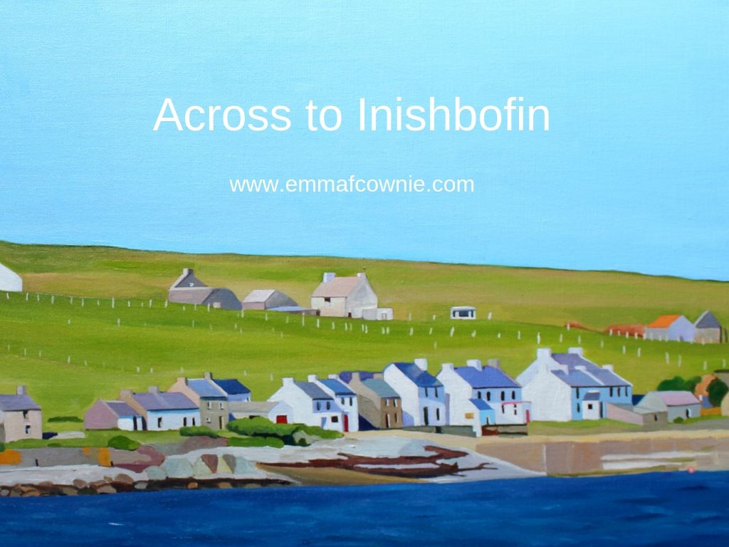
Much closer than Tory Island is Inishbofin. It’s a mere 3km (1.8 miles) from the mainland. I took photos of the houses on the island with my zoom lens. They were still very small.
Inishbofin, Donegal
I originally wanted to paint this whole stretch of the island’s coastline but I realised that without a more dramatic (cloudy) sky, most of the canvas would end up being a lot of light blue and a tiny strip of land at the bottom of the painting. So I chose a section of the coastline and focused on the details of the houses that I could make out.
I get a lot of pleasure from looking at the clean lines of the old houses – I also enjoy a landscape with no cars. If you have eagle eyes you will spot a solitary caravan on the hill above the main street on Inishbofin. The island is approximately 1.2km wide and 2km long with a small seasonal population of about 50 people, who are Irish-speakers. I believe, a few hardy souls live there all year round.
Here’s a lovely video about the people who live on the island in the summer months. It’s in Irish (as they are Irish-speakers) but there are subtitles.
I get very attached to my Donegal island paintings. I’m not sure why. Maybe its because I get such pleasure at looking at those unmodernized houses. I like the length of the image too. Perhaps it because, so far, I have looked across the sea at them and had to reconstruct the landscape with care.
Across to Inishbofin (detail)
It’s hard to explain, but it’s like my mind has “felt” the shape of the land, the rise and fall of the shingle beaches, the spread of seaweed on the shore, the rocks and hills behind the houses. It’s usually my paintings of animals that find it hard to part with!
Across to Inishbofin SOLDInish Bofin beach
That house with a red front door on the right side of the painting is for sale.
Teach Johnny, Inishbofin Island
Many of the islands have seasonal boats. We are planning to visit one or two of these island in the next few weeks when we are back in Donegal. My list of islands to visit include:- Gola, Inishbofin, Tory and Owey. I don’t think we will manage more than two of those this visit. It depends on the weather and energy levels.
Here are my other Donegal island paintings (I have parted with two of these).
Spring Light on Gola – Seamas’s favourite painting!
Bunbeg. The word has a pleasing sound to it. It’s short, easy to say and has a nice rhythm to it. Most place names in the British Isles are simply descriptions of locations, or who used to own it. That is not always obvious to modern English speakers because the descriptions originated in Anglo-Saxon, Welsh, Gaelic (Scots) or Gaeilge (Irish). Therefore, when speakers of the Celtic languages use a place name they have a ready made description of the place. It’s the same with Bunbeg. Bunbeg is the anglicised version of “An Bun Beag” which means the “the small river mouth”. I know very little Gaeilge but once you start picking up words you see them everywhere. Beg meaning small – there’s Derrybeg (Doirí Beaga) just round the corner which means small oak.
Bunbeg is located in an area of Donegal known as Gweedore (Gaoth Dobhair), known as a bastion of Irish music, language and culture and home to legendary bands such as Clannad and Altan. If you are as old as me you may well remember Enya’s “Orinoco Flow” which was a hit in the UK way back in 1989 and seemed to be played everywhere. Enya was originally a member of Clannad.
Gweedore is the largest Irish-speaking parish in Ireland with a population of just over 4 thousand people. I enjoyed listening to two fisherman having a good gossip in Irish at Bunbeg harbor round the corner from here. I no idea what they were saying but the conversation went at a good pace. I enjoyed just the sound of the language and comparing it to the sound of Welsh which I am familiar with.
Fisherman (not gossiping) in Bunbeg Harbour“Eddie”
Anyway, back to Bunbeg. The vast tidal sands that stretches across the indent in the coastline is known as Magheraclogher beach. When I say, vast I mean vast. It is one of the best known beaches in Gweedore, largely in part because of the distinctive shipwreck that’s been there since the 1970s.
It is known locally as ‘Bad Eddie’ or Eddies Boat. It has regularly appeared in Music Videos as well as providing the backdrop for countless wedding photographs and instagram posts. That mountain in the distance is Errigal, which also features in countless music videos, photos and paintings.
“Eddie” with Bunbeg and Errigal in the background
Usually photographers shoot him at low tide. Here’s the photo they use on Wikipedia.
Bunbeg – Wikipedia image
I decided to paint a different view of Bunbeg, without “Eddie”, because I liked the reflections of the clouds in the shallows, I thought it made for a more dramatic composition. I thought the rain clouds also gave a better sense of the mercurial nature of weather of Donegal. It was also windy when we were here although, I would say that wind is a pretty much a constant feature of the “Wild Atlantic Way”.
From Magheraclogher Beach (SOLD)
This beach is popular with dog walkers and tourists as it is easily accessible, with a car park. Yet, I say “popular” the other people we saw were dots off in the distance.
For information on the history of Gweedore area click here
I like to explore nooks and crannies and I usually use a map to help me. This way I can find interesting scenes to paint. I love looking at maps but I didn’t have one in Donegal. I thought I’d get one with the hire car but instead we were given a Stat Nav (Satellite Navigation). You can’t spend hours looking at the lay of the land on a Stat Nav. It spent the holiday in the boot of the car. I thought we’d get one in a filling station but in Ireland you don’t fill up your own car and wander into the garage shop to look at car related stuff and packets of sweet, you have a friendly young chap filing your car up for you! We sort of knew where we were going. My husband, Seamas, had spent hours “driving” down the roads and lanes of Donegal on Street View Google.
The Lone House on Fall Island
So, in the spirit of adventure I turned off the coast road, which runs from the airport to Dungloe, in search of the sea. The roads are narrow but fortunately we didn’t meet anyone coming the other way. After following an undulating single track road, it widened out and then seemingly vanished over a hill into the sea. I didn’t fancy doing a lot of reversing so I parked up to explore on foot. Over the other side of the rise was the beach. It was low tide. The track I’d been on ran down to beach and then started up again on a island on the other side of the beach.
Beach between Fall Island and the mainland
This is Fall Island and it is only 300 metres long. There is only one lone house on the island. The house was shut up for the winter.
The rocky Rosses
I was fascinated by the rocky landscape and the houses perched on the rocks. These rocks are made of granite. Granite is an igneous rock which it was once magma which crystallised as it cooled down. It’s a dense and useful rock. It can be cut, carved and shaped. It is also resistant to water and pollution.
From Fall Island
The granite rocks along the coastline are massive. Monumental. Their edges smoothed by the sea and the wind.