I am delighted to announce the publication of my latest book “Footnotes, An Artist’s Journey Around the Gower Coast” which is based on my walks and blogs of 2018.
My book on Medieval History
Many years ago I turned my Ph.D. on Medieval History into an academic book. That was jammed packed with footnotes and had almost no pictures (except for the front cover) but it did have some maps hand-drawn by me. I felt quite odd when that was published. I suffered terribly from imposture syndrome, then as now, and it almost felt like someone else had written it when I looked at the words on the book. Don’t get me wrong, I had written every last bit of it, the text, the footnotes, the index but it didn’t feel like it had much of “me” in it, except maybe in my dedications. I think my parents and Seamas, who was my boyfriend back then, appreciated being thanked for their support.
This book is quite different. Ironically, despite the name, the only “footnote” in it is the title. It’s a bit of a joke, I guess! This book has a lot more of “me” in it. Yes, there still some local history and stories about Gower, but its mostly about the walk and dealing with my anxieties.
I had spent weeks editing it and sort of ran out of steam when I reached the part where I had to upload it to the Kindle website. Thankfully, my husband, Seamas, came to rescue and was midwife to the whole venture. He did the final editing and proof-reading and it uploaded to the website. Which sort of sums up our relationship, he’s always there to help me over the “humps”, not just as a cheerleader but as technical support and he also provides so much inspiration. So thank you, Seamas.
I also want to thank my parents who have always supported whatever I have done. My mother is a fervent “liker” on Facebook. Their house has many of my paintings hanging on their walls, which is a compliment in its self as superfluous objects are either returned to the donor or end up in the local Charity shops. I also want to thank supporters on Instagram who tell me that they have downloaded from Kindle or bought the physical book.
I hope that people enjoy it as much for the walks and stories about Gower, as for my paintings!
Life as an artist is a very insecure one, you never know where your next sale is going to come from. You can plan and prepare for exhibitions and work on your social media, but it’s impossible to know how many people will see and respond to them.
That’s why it’s really important to take stock, and celebrate the success you have achieved and thank all the supporters and collectors who have helped you over the year; whether it’s a positive comment on a blog post, a “like” on facebook or an instagram post, the sale of a mounted print, a greeting card, a commission or the sale of a painting. They all help keep me going! You may not believe it, but artists have fragile egos (this one has, anyway) and they need encouragement, especially if they venture off into new directions, as I so often do.
Here’s a review of some of my sales of paintings and mounted prints from the first part of 2018. Many were sold via the online gallery Artfinderbut increasing I have sold direct via my own website. Each painting is a unique work. I don’t paint generic people or landscapes. They are all real people and locations. In April’s collection you can see many of the Gower painting I did as part of the Gower Coastal Path Project. Bloggers’ comments and encouragement really helped me complete that project. Thank you, all.
January Sales 2018February Sales 2018
March Sales 2018
April Sales 2018
My next post will complete the review. Thank you to the brilliant people who have supported me and bought my work this year, I couldn’t do it without you!
We didn’t get an “Indian Summer” in September, which when we usually get one in Wales. What we have had, instead, is a series of sunny days in late October/early November. The sparkling autumn light is stunning. From a painter’s point of view is more interesting than summer light. So last week I drove down to Three Cliffs Bay to enjoy the light. I was surprised by the dark blue of the calm sea. It was quite a different colour from the summer sea.
Three Cliffs Autumn Light
I was hoping that there would be plenty of orange bracken and there was. Not on the slope of the the Three Cliffs, as they are covered in grass, but on the slopes of Cefn Bryn, in distance.
Painting of Pobbles Bay, Three cliffs, Gower
These colours sum up the Welsh landscape for me. In fact, I think I like the Welsh landscape in autumn/winter best. The red and the green of the bracken and the grass also put me in mind of the red and the green of the Welsh flag.
Welsh Flag (an interpretation)Light on Great Tor (Gower)
I find it ironic that there’s less light around but its better quality, from an artists’ point of view. I still have not adjusted to the clocks going back last month, and I am still waking at 5 -5.30am! It does not seem to matter what time I go to bed, I awake in the dark feeling ready to rise. So I get up and here I am tapping away at my computer in the dark waiting for the sun to rise. Soon I will have to get my SAD lamp out to stop the slow slide in winter gloom. Before, you ask, yes, SAD lamps work for me.
Does anyone else suffer from this problem? Does anyone have any tips for sleeping in later?
Update: I sat with my SAD lamp on for 20 minutes around 7 pm last night and it seemed to help me go back to sleep when I awoke at 4.30 am, and I didn’t get that “wake up” surge of hormones til 6.30. A definite improvement.
I did not walk the length of Worms Head at the same time as my other Gower coastal Walks. This was because you cannot walk its full length between the 1st March and the 31st of August – as the last part of the Worm, the Outer Head, is closed in order to protect nesting seabirds.
So I waited until late October for a sunny morning and a low tide to set off on my adventure. It was certainly an adventure as I travelled alone and there was plenty of scope for “mild peril” and twisted ankles and, at one point, there was definitely outright fear. More of that later.
The drive down to Rhossili was beautiful. Autumn sunshine lit the russet trees and the long shadows stretched across the road. The forecast was for a fine sunny day but by the time I arrived at Rhossili, it had clouded over. I got of my car and wished I had brought a woolly hat instead of my sunhat jammed at the bottom of my bag underneath my sandwiches, banana, and the compulsory chocolate biscuits. The biscuits had been lurking down there since my last walk several months ago, but as they were individually wrapped I decided they’d still be very edible. The walk down the National Trust car park to the coast guard station at the end of the headland took longer than I expect it.
Worms Head (from Rhossili Downs)
I think this is because I am usually so mesmerized by the sight of the “Worm” that I don’t really pay attention to how far I am walking. The Worm (“Wurm”) means dragon, and it was given this name by the Vikings who regularly sailed the Bristol Channel over a thousand years ago.
Worms Head
It is a long tidal island that undulates westward like a sea beast. The shape of it changes depending on which angle you approach it. Sometimes it seems coiled, other times in snakes from side to side.
Towards Worms Head (SOLD)
I think I look up the tide times for Gower more often than most people, except for surfers. Every time I go to the coast I like to know if it going to be a low or high tide, depending on whether I want to photograph it or swim in it. If you want to visit Worms Head, a low tide is essential because the causeway over to the islands is only safe to cross 2 and a half hours either side of low tide.
I know that to be caught out ensures an extra long stay on the island (as happened to Dylan Thomas once), because swimming across the short stretch of water is very dangerous and I can remember a man who died attempting in it a few years ago.
Coast Watch Station
Fortunately, if you have forgotten to look up the tide timetable, it is clearly displayed outside the coast watch station and on the path down to the causeway. That is pretty much, the point of the coast watch station, as I have mentioned before. To watch out for fishermen and people who might get trapped by the rising tide.
Map of Worms Head (Note: High Tide)
When you arrive at the coast guard station at the end of the headland you will see the path in front of you dropping down to the causeway. Now, don’t believe any guide that tells you that this is “easy” as I have seen elsewhere online. It is not. Parts of the island are easy. Most of it and the causeway, in particular, is very very, rocky.
It resembles an assault course rather than a “walk”. There are slightly easier routes than others but they are all energetic to some degree and require a fair bit of climbing, jumping, or in my case sliding down rock faces on my backside. I was better prepared than the time I walked across it on whim one summer with my sister and my 7-year niece. That time I was wearing sandals. This time I was wearing sturdy walking boots. I regretted, however, wearing my drainpipe jeans. There were many times I could not tell if I was stiff with age or stiff from my sartorial stupidity. Nevertheless, I soldiered on.
Looking across the so-called causeway, I could not see an easy route. I could not even see an obvious way down to the causeway. Hence I ended up sliding down the rocks, hoping that I didn’t twist my ankle. That was a recurring thought throughout the morning. The trick is to stay focus 100% on where you are putting your feet, if you need to look up, then stopping to do so. Walking along and looking around at the same time was out of the question. I decided to follow a mother and her two young sons, hoping that they would find a sensible route across the rocks.
The Causeway
I think they must have been part- mountain goat because they zoomed across the rocks, sure-footed and totally fearless, happily chatting away to each other. I struggled to keep up. I started off feeling a bit chilly but by the time I reach the island 20-25 minutes later I was hot and thinking of taking off my jacket. Again you will read in some guides that it takes “about 15 minutes to cross the jagged and slippery rocks” but I found it took longer. Perhaps I stopped and looked at the view too often.
Worms Head OS Map (Low Tide)
Arriving at Inner Head, I was greeted by more warning signs, a tide timetable and a bell to ring to gain attention, if you are trapped by the incoming tide. Here, I had a choice of paths. Either to climb the back of the Worm and walk along its spine, or to take the easier lower path to the west. I took the easy path. It was my favourite path of the day. I could trundle along it, looking at the view, without worrying that I was going to trip up!
I quickly reached Low Neck which bends round to Devil’s Bridge.
Devil’s Bridge, Worms Head, Rhossili
Here, I could see I had to cross another assault course of massive fractured rocks to get to Devil’s Bridge. This is all that remains of a collapsed sea cave. It too will collapse one day, dividing the Middle Head in two. I decided instead follow a long climb over the tooth-like slabs down to the rocky “beach” part of Worms Head, to take some photographs of the Worm’s reflection in the still seawater.
I then had the joy of trying to make it back onto the path. It was a long scramble/climb and at several points I wondered if it was possible but I did eventually make it without injury.
So I finally reached the Outer Head. I was greeted by a warning sign telling people not to visit during nesting season. There were yet more rocks to clamber over before I finally reached the dragon’s head.
Here the path got steep. The grass became much thinner and the rocks were worn smooth with years of walkers’ boots on them. I scrambled up where I thought the path would flatten out a bit. Then I realise that the final part of the “walk” involved a climb up an almost sheer cliff. The mother and two sons I followed across the causeway earlier, were already fearlessly climbing up the rock face. I noted that the mother wasn’t totally cavalier about letting her boys follow her as she told them in no uncertain terms that they must listen to her instructions and have “three points of contact with the ground at all time”. I bore this advice in mind, for the rest of my trip on the Worm.
I watched, with my heart in my mouth, as they zoomed up the rock face like sure-footed monkeys. I don’t like heights at the best of times, and I knew this was beyond me. I could not face trying to climb up there, in case I freaked out half-way up. More eager climbers made their way past me. The prospect of an audience decided it for me. I turned around and started my return journey, muttering to myself “I know my limits”.
Trust me, it’s a long way down.
As I walked back I ponder my long distinguish career as a scaredly-cat. As a child I freaked out in some underground caves, Cheddar or Wooky Hole, I’m not sure which, discovered to my surprise that I was decidedly claustrophobic. As an adult, on a school trip to Disneyland Paris, I was persuaded to go on Space Mountain. I only survived the experience by keeping my eyes tightly closed for the whole trip. Apparently a lot of it happens in the dark but never once opened my eyes to find out. More recently I climbed almost to the top of Mount Snowdon, in North Wales, only to decide I could not make it to the summit. The path was very narrow and there were hoards of people. I was convinced that I’d get pushed off the path to my death. So I sat down with my eyes closed (again) and waited for my brave husband to make the journey to the top and back on his own. Yet, I enjoy watching films about Mountaineers, like “Touching the Void” and “Everest”, go figure!
I stopped and ate some biscuits and sandwiches, drank a lot of water and admired the view along the Worms’ back in both directions, towards its head and in the other direction towards Rhossili Bay and Gower. This time I walked over Devils Bridge and started the scramble over more rocks to Inner Head.
Seal, off Worms Head
I paused as I see another walker looking out to sea and I realised there is little head looking up at us out of the water. It was a seal. I could see his whiskers. He reminded me of a dog. I don’t know if he’s a common or grey seal, as they are very hard to tell apart, especially when they are in the water. He disappeared and then popped up again, before finally vanishing for good.
Keeping an eye on time time, and making sure I have more than enough time to cross the causeway, I made my way back to the south-eastern end of the tidal island. I notice a group of people are watching something on the stony beach below the cliffs. More seals! I settled down on the grass to watch. To start with, I could not get a good view, as there were so many people. Eventually after a lot of loud “Oh” and “Ahhhh-ing” (I don’t think the seals liked this as they kept looking up), the people moved on and I had the seals all to myself. I love this.
I watched them, very happily in silence, for quite a while and make some film clips to show my husband later. I am guessing they are the smaller, common seals, but I could be wrong.
I am very tired now and as I start my walk across the causeway, I see people still crossing over from Rhossili. I look at my watch. They still have two hours to cross and back it back again. I start off with confidence, only to have to retrace my steps because the drop from the rocks I am on is too high.
As I am struggling down from a lower crag I am surprised by a strange animal-like snorting sound. It sounded a bit like an alarmed dog. I looked around at what I thought were barren rocks, only to realise that I have a pair of anxious eyes looking at me. It an adolescent seal, stranded all on his own in the rocks. I quickly retreated. I didn’t want to frighten him any more than I already had.
Hidden amongst the rocks
He must have been stuck here ever since the tide went out three hours ago. I briefly worried about the other walkers finding him, as some of them have dogs with them, but I decided that if I keep quiet, maybe no one else will discover him. I know that the usual advice with wild animals is to retreat and leave them alone. After all, he is so well camouflaged, I would not have seen him if he had stayed silent. In fact I did not seen him when I came across earlier.
Spot the seal
Thankfully, crossing the causeway was slightly easier on the return journey. I think the tide was further out so I could walk alone the pebbly edge, although the climb back up the to main path was brutal.
Worms Head, Rhossili, Gower
I was relieved to be back on the main land, but there is some thing very special about being on an island, even if it’s only a tidal island like Worms Head. I think its because you are surrounded by the sea and that is an exhilarating feeling. The Gower is a bit like a tricorn hat, with a tidal island at each “corner”. This journey around the Gower coastal path started with Mumbles, with its lighthouse built on a tidal island; Burry Holmes is a tiny full stop marking the north end of Llangennith Beach but Worms Head is a comma. Not so much a footnote, but a wiggly tail making off towards the Celtic Sea. The open sea and more adventure.
Map of Gower Peninsula
To see landscape paintings available to buy please clickhere
I am very delighted to say that we returned from Donegal to the news that you can now buy my work as framed prints at John Lewis! If you are not familiar with John Lewis, they are a British “high end” department store, who also run the Waitrose supermarkets. They have stores in the Republic of Ireland and Australia.
These two images are available from John Lewis stores throughout the UK “Drifting Clouds” and “Great Tor From Tor Bay”.
After working on my New York interior, I felt ready to return to the theme of rocky coasts. I was revisiting Mewslade Bay again, but a more panoramic composition with the tide coming in. My previous painting had been all about majesty and rocks but this one was different, it was more about colour and light. In particular I wanted to revisit some of the shadows that I’d found hard work in my previous painting and find out if I had left the “difficult bits” too long and whether I should have tackled them sooner.
#1
Unfortunately, this painting fell into place a lot quicker than I expected and I only remembered to take a work-in-progress photos after I’d “solved” the rocks. I think that the addition of the grassy promontory, called “Devil’s Truck”, helped add a lot of interest and colour to the composition. It draws the eye to the left of the painting and away from the less interesting (in my opinion) shadowed part of the cliff in the centre. In the early stage of the painting, the foot of Jacky’s Tor (the peak on the right of the painting), is too light but I will adjust that later.
#2
I paint the sand/reflection that will be partially covered by an incoming wave. I leave it to dry over night.
#3
I darken the foot of Jacky’s Tor. I am a bit nervous about painting the incoming sea but my artist husband just advises me not too “think” about it but just paint it. He’s right and I consciously shut off my critical voice (or is that the left hand side of the brain) and get on with it.
#4
I complete the sky. It passes the view-from-the-other-side-of-the-room test. I am pleased with it. It is less monumental than my previous Mewslade painting of Jacky’s Tor but I like its colourful energy. The warmth of the beach brings a lot of elements of the painting together.
Mewslade Reflections (Sold)
To see original artwork for sale click here
For large mounted prints click here or regular sized mounted prints here
I am not well. I have a virus that makes me feel tired, my arms in particular feel heavy, my throat feels sore and I struggle with social interactions. The sense of illness ebbs and flows. I start off the day feeling rough but by the evening, I feel a bit better. Yesterday I felt terrible most of the day but strangely found myself defrosting the freezer at 8pm. I had fancied an ice lolly to ease my sore throat but I noticed that freezer door would not close. Obviously, the last person to use the freezer had not shut the door properly. So, I cleared the freezer of its content, switched it off, and got the steam cleaner out. Forty-five minutes later all the ice was gone and the content was back inside neat frost-free drawers.
I have struggled to write this post. I deleted my first two attempts as I kept going off at tangents (see defrosting freezer above). Thankfully, illness hasn’t stopped me painting. I started this large painting (92×73 cm) of Mewslade Bay but I made slow progress. Mewslade Bay is just round the corner from Worms Head and Rhossili Bay. There is no beach to speak of at high tide. At low tide, however, the sandy beach can be reached if you scramble down over some slippery rocks, and thick beds of seaweed that have been washed up against rocks. I had got up at 5 am to drive down to Mewslade to catch it at low tide. Although the majority of the sky was clear there was a spattering of mackerel clouds just above the horizon. The light was hazy and I had wait 45 minutes before I got a blast of bright sunshine on the cliff face.
I think I should have started with darkest parts of the image, rather than the lightest parts.
As I had to go back and darken the rocks in the distance and in the shadow of the furthest peak.
Adding the beach and shadow under the cliffs helped “intensify” the dark part of the cliffs.
Finally, adding the morning sky made sense of the blues and purple shadows on the east facing cliff faces. Some paintings seem to make sense straight away and with others, like this one, you have to wait until all the elements are in place. I particularly love the way the peak in the foreground casts its shadow on the second peak. It reminds me of a tiny Everest! The bright morning light makes the rock face look like a snow covered peak.
When I get hold of an idea I can get quite obsessive about it. Lately, it’s been early morning light. I think it sprang from a post I wrote about transposing some of the techniques I used for my “Urban Minimal” project to what I only half-jokingly called “Rural Minimal”. I think that my rural Gower houses did fulfil the spirit of “Rural Minimal” but it got me think about shadows. Now, shadows were my first love. They still are. It’s hard to find any painting of mine without blue/mauve/purple/brown shadows. I go through tubes of Lukas 1862 Mauve at a steady rate. Many of my Gower woodland paintings used early morning winter light.
[wpecpp name=”Enchanted Wood Large Print ” price=”45″ align=”left”]
And why do I love shadows so much? It’s because they act as a foil to the light. The orange next to the dark mauve positively leaps off the canvas. Perhaps, its a cheap way of thrilling the viewer? I am always very impressed by artists who capture a gloomy or overcast landscape. Plein Air painters prefer overcast conditions because they are more constant and American artist, Jeremy Sams, demonstrates this really well in his painting. He says “The good thing about painting on an overcast day is that you don’t have to chase shadows. The light remains very constant and my acrylic paints stay wet for a good long while.”
Jeremy Sam’s Plein Air Study
However, I love shadows. They make a composition interesting and dynamic. So, anyway, the post about Rural Minimal got me thinking about shadows in rural settings. I realised that because I have been focusing on my Gower Walks and working to bus timetables that I was mostly walking in the late morning and finishing up in the early afternoon. I was becoming increasing frustrated that my lovely walks weren’t inspiring the sort of paintings I like to make. The light wasn’t right. Midday light, especially in the summer, has a tendency to bleach out the details. This is what shadows “do”, they show us the details of the landscape.
Light Shadow (SOLD)
I have always been a morning person. Each morning is like a fresh start to me. What ever happened yesterday, last night is gone.To be honest, I think that have always done my best work by 11 am. When I was writing my PhD thesis, many years ago, I’d do my best writing between at 8 and 11 am. To be honest, most of the work I did after 11 am was fact checking (this was in the days before the interest when you had to look things up in books) and faffing, but I’d dutifully stay at my desk til 5 pm.
Bernard Street Bus Stop (Back of Brynmill Launderette) SOLD
So I decided that I need to seek out early morning light on Gower. This long spell of hot weather meant that morning skies were often (but not always) clear. That meant getting up early. I have been dragging myself out of bed just after sunrise. It’s summer and the sun rises just after 5 am in here Wales. It is painful getting up that early but once I have had a cup of coffee I can face the outside world, just about.
The first time I drove down to Three Cliffs Bay, 6 miles away, I was so tired that I actually forgot my camera! I felt so stupid but I got back in my car and drove back home to fetch the darn thing, delaying my “start” by 30 minutes.
Pobbles Bay after 8am
Compare the light and shadows to yesterday morning (when I remembered my camera) and actually got there for about 6.30am.
Pobbles Bay 6.30 am
It’s different. Not necessarily better, just different. Do you know what, it doesn’t matter. I like both conditions. The changing tides always also variety and interest. Summer Morning light has a beautiful rich quality to it and I like seeing how it changes, the shadows shorten, darken, light break over the cliffs, as the morning progresses. I have sat down on the cliff tops and watch the light change.
Early Morning, Three Cliffs (SOLD) (Oil on Linen canvas, 80×60 cm, unframed)
I like seeing nature first thing. I like seeing the dew. In this very dry summer it’s a godsend. The grass on rolling fairways of Pennard golf course has turned the colour of straw except for the patches where the dew collects in the morning. There it’s a fresh green. Walking down towards the sea, along the sandy path by the golf course, I often see the white tails of wild rabbits dashing into the undergrowth. Their numbers in the UK have fallen in recent decades but thankfully, there seem to be plenty on Gower.
Welsh Wild Rabbit
Free-range cows roam the cliffs of Pennard and South Gate as well as the valley next to Three Cliffs Bay. They are usually busily eating the grass they can find down in the marshy valley or in the shadows of the thorny gorse bushes, or even in the Golf Club car park before the golfers arrive!
Cow at Pennard
Cows chewing the cud (mid morning) and cows at work, eating grass (early morning).
I delight in the long shadows and the reflections at low tide. How the reflected light is more golden than the light on the rocky cliffs.
Three Cliffs Reflections (SOLD Oil on Linen canvas , 80x50cm, unframed)
At high tide the colours all change again.
I have got up early and visited Rhossili, Penmaen and Three Cliffs Bay six times in the past fortnight. This includes the morning I thought the light cloud would clear but instead it thickened. A passing Jack Russell was photographed, as well as the rabbit above. So, I sat down and sketched.
I will keep going until this weather goes off, while may well be very soon. I will be working from this research for quite a while after it has clouded over again.
A while back, last June in fact, I read an excellent blog post by American artist Luann Udell entitled “How Long Did It Take You To Make That?” in which she discusses all time-consuming processes and skill that go into creating her pieces. It occurred to me that while the actual time it takes to paint my work may take anything from one to three days, depending on the size of the canvas, the actual thinking, planning, gestation, waiting for the weather and preparation takes a lot longer. I should also include in that waiting for the seasons to change. Just yesterday I was remarking to my husband that the heather was starting to flower and so another visit to Rhossili Downs would be in order soon. Nothing stays the same in nature, or in life! My job is to observe and attempt to capture some of those fleeting changes.
Enquiries about Commission Always Welcome – Find out more here
The Gower boasts two gems that most visitors never see. I have lived in Swansea for 19 years and this was the first time that I saw them. These are Three Chimneys, a sea arch that used to be two arches, and a massive rock pool known as Blue Pool. These two marvels are not easy to find. They are tucked to the north of Broughton Bay. They are located on Blue Pool Bay, in the northern-eastern corner of the peninsula. You cannot drive to this bay but have to walk.
I ended up doing the walk twice in one week. The first time, it was sunny when we set off from Swansea. We had sun hats too. The car park next to Broughton Caravan Park, where we start the walk, was free. This is a rare thing on Gower. We are forever pawing through our change to find enough pound coins for the ticket machines. They never seem to take £5 notes or credit cards. This car park sits next to a large static caravan park. Many of the people who own caravans here live close by in Swansea. It has a friendly family feel to it, it has palm trees and little gardens.
Almost as soon as we got out the car it clouded over. We walked through the large static caravans and along a path covered in wooden slats, which was wonderfully easy to walk along.
As the path snaked around the hill and entered dunes the clouds came lower. The further along the path we progress the mistier it got.
Not a lot to see!
Eventually, we see can Three Chimneys from the top of the dunes. It was clearly two arches, once upon a time, but one has collapsed.
Three Chimneys
We walk on until we reach Burry Holms, another of Gower’s three tidal islands (the others are Mumbles and Worms Head). Just over nine thousand years ago, it was not an island but a hill nine miles from the sea. There is a lot of archaeology here, including a Mesolithic site, a Bronze Age burial mound, an Iron Age fort with a deep defensive ditch and bank, and the remains of a monastic settlement founded in the 11th century and abandoned during the 17th century. There are also a number of post-Medieval quarries and limekilns are along the cliff edges.
Burry Holms in the Mist
No one knows why it is called Burry Holms. There is a port across the Loughor estuary called Burry Port, but Burry Port in Welsh is Porth Tywyn which means White House Port (I think). I’m not sure what the Burry means in this case, but Anglo-Saxon a “burh” usually means a fortified town. Many of them date back to 9th century when raids and invasions by Vikings prompted Alfred the Great to develop a network of burhs and roads to use against them. I know that the island’s name of “Holm” comes from the Old Norse meaning “island in an estuary” (think of Flat Holm and Steep Holm further out in the Bristol Channel). This also reflects the Norse domination of the waterways in this area, which lasted up until the 11th century. After all Worms Head (Wurm – meaning dragon) is also a Norse name.
The ruins of the 14th-century chapel dedicated to Saint Cenydd can also be seen at the eastern end of the island. St Cenydd, sometimes Anglicized as Saint Kenneth, was a Christian hermit who founded a church at Llangennith, to the south of Burry Holms. The story of St Cenydd’s early life is wonderfully fantastical and not to be taken at face value. Cenydd was supposedly a Breton Prince, born of from an incestuous relationship, at Loughor (this is a modern day suburb of Swansea).
Baby Cenydd was born with some sort of disability, and on account of this he was put in a willow basket/cradle and launched into the River Loughor, like a Celtic Moses. This willow basket eventually washed up on Worms Head and the local seagulls and angels looked after the baby and somehow managed to bring him up as a Christian. Interestingly, St David, Wales’s patron saint, cured Cenydd of his disability in later life. Was St Cenydd at all grateful? Not a bit of it. He wasn’t happy about this at all and actually prayed for his disability to be restored!
What is going on here?
So we sat looking out at Burry Holms eating biscuits. We watched a seagull swoop and circle the cliffs again and again. He did this at least ten times. I was trying to decide if he’s was scaring off some jackdaws or was jealous of a courting couple.
Love is in the air!
Another pair of gulls sit cosily together on a ledge. Then, suddenly the male mounted the female and a quick bit of mating takes place. The male then abruptly flies off. “To the pub!” my husband drily observes.
On the way back I try and find the rock pool, Blue Pool. We seem to have missed it on our way to Burry Holms. I clamber down a hill and finally spot it nestling in the rocks below.
Blue Pool
I can see people in wetsuits leaping into the famed rock pool. I am very jealous. Local legend says it is bottomless. The swimmers seem to be very confident they won’t hit the bottom as they leap into it.
Jumping in!
Two women climb to the top of the highest lip of the pool and leap into the water. It looks great fun. I read later that it is very deep. Anything from four to eight metres deep, depending on tidal and weather conditions. As much as I enjoyed watching the fun and games I was a little frustrated.
I’ll show you why. This is what I was hoping for compared with what we saw.
So I went back to get another look at Blue Pool and in sunshine this time. I returned early one morning later in the week alone. I set off at 8.15 am hoping to catch the low tide because I have the idea that you can walk around the headlands and walk to Blue Pool Bay. This time, it is cloudy in Swansea but brightens up as I reach Llangennith which is just down the road from Broughton Bay.
So I walk onto the beach full of confidence that I will be able to walk to Blue Pool Bay along the shore. I couldn’t.
View Across Broughton Bay
I don’t know if it wasn’t a particularly low tide, I have discovered since that not all low tide are the same. Some are lower than others. Just as some high tides are higher than others. So I had to retrace my steps and I clambered up the rocks as a short cut to the coastal path. I eventually made my way along to Blue Pool Bay – I found a different path that led down the dunes and some very steep rocks.
I kept my rucksack with me, so that if I fell, I’d have my phone with me, or at the very least water and biscuits! I did have the over-dramatic thought that if I fell, no one would find me for hours/days. I chickened out of climbing all the way down to the sandy beach as the tide has just turned. I knew the tide came all the way in, leaving no beach at all. I wasn’t sure how quickly the water would come in.
Blue Pool Close up.
I climbed back up to the coastal path OK. I then carried on to Burry Holmes and the vast three-mile expanse of Rhossili Bay.
Burry Holms
I walked along the beach towards Worms Head. I ate my banana and put the skin back into my bag. I had seen enough rubbish on the foreshore to depress me. I watched the little wadding birds, sanderlings, I think running along the surf on their delicate long legs.
I retrace my step along the path through the dunes and I enjoy the silence which was broken only by the song of a skylark, one of my favourite sounds. I pass the caravan site and carry on along the sweep of Broughton Bay.
I saw the white tails of rabbit disappering into the undergrowth in a fields filled with sheep and their lambs. I then come across another caravan park. This one is called Whiteford Bay Caravan Park. It seems an unfriendly place. There are lots of warning signs and no trees. Broughton Bay Caravan Park seems much more relaxed, with its palm trees and little gardens and free car park.
I pass a group of senior hikers, including a chap who must be in his 80s. There’s a role model, I think. The path climbs up a sandy path up to Hills Tor.
The View Across the Estuary
I sat down on a sandy ledge to admire the expansive view towards Whiteford Point and try and make out the rusty iron Victorian lighthouse. I can just about see it. You can’t see it in the photos. It is very breezy up here.
View Towards Whitford Point
I ate two chocolate biscuits. They are delicious but I have drunk most of my water with only a couple of mouthfuls left. So because I know I have so little water left, I start obsessing about water on my walk back to the car. I cross a little stream that runs from Moorlake into Broughton Bay and consider trying to take a mouthful of it. It is quite marshy here behind the burrows. The sea is out of sight. I decide that in future I will carry two bottles of water with me.
There are Two boys are playing on the tops of the dunes. They are school-aged- why aren’t they in school, I think to myself. Once a teacher, eh? I say nothing and pass on.
By the time I reach Broughton farm it has clouded over. My calfs are now aching from so much walking on sand. They carry on aching later on in bed. I’m not surprised when I work out that I walked 6 and a half miles, and a lot of that was on sand.
Next walk is Whiteford Point for a close up view of that iron lighthouse.
Three Chimneys Arch, Gower (SOLD) Available as a print.
This is the most challenging leg of my journey around the Gower coast, thus far. It is the longest walk I have done so far at 6 and a half miles. For some reason, I keep thinking its much further than that. I had convinced myself that it was 8 miles. It felt like that.
I have been obsessing over the bus timetables and the information I have garnered from Traveline.com which makes sense of the bus connections for me. I have written all the available buses in my note book which I carry in my rucksack as well as on a cheery yellow post-it note which I have in my coat pocket. I have tried very hard not to think of all the things that could go wrong but at 4 am I have persistent visions of twisted ankles and buses not turning up. I pack two plasters although I suspect they won’t be massively useful if I do twist my ankle. Yet, it seems that I have done all my worrying in advance for once I set off everything pretty much goes without a hitch.
It is a warm day. I am wearing my light padded jacket for the first time this year. My rucksack, which is actually my husbands old laptop rucksack, contains the following:- Water bottle; food – sandwiches, banana, biscuits; bus timetables for all Gower buses; tide timetable; two plasters; spare socks; camera; handbag. Somehow I haven’t organised myself enough to leave my stupid handbag behind. I know it has many useful things in it like a tape measure, make-up mirror, phone, fold away shopping bags, but I suspect it adds a fair bit of weight.
I dont have to wait long for the number 118 bus to arrive on Gower Road in Swansea. The bus driver blinks at me slowly when I ask “Change at Scurlage?” This is the first time I have been on a NAT bus. That stands for National Adventure Travel. As a car driver, travelling on a bus has a certain amount of novelty for me and looking out the grimy windows is almost a treat! This bus is OK but not as nice as the city First Cymru buses. Buses seem like things of the city to me (I am a townie born and bred) but once we rattle over the cattle grid at the edge of Fairwood Common and leave Swansea behind, there are great views across the common towards Cefyn Bryn, the long hill that extends across Gower. I enjoy the superior height of the bus which means I can look over walls and into people’s gardens as they flash by.
It is high tide as Three Cliffs Bay as we pass, a sight that gives me a small thrill. We pass the campsite at Nicholston and two walkers, a man and woman, get on. I have company. They both have rucksacks. I wonder why they have one each. They can’t both have handbags in there!
Scurlage. Thankfully the connection is waiting. We climb down from our big bus and into the smaller bus with hard seats and a sunroof.
It takes a long and winding route, pause for 3 minutes in a lay by, and then on to Horton, past a vast caravan park and eventually down a steep hill past the church and into Port Eynon.
Chips at Port Eynon
Port Eynon on a long sandy bay on the South coast of the Gower Peninsula. It is the second largest “indentation” on the coastline. Truth be known, it is my favourite Gower place to visit in summer because it always has plenty of space on the beach, a shallow sea which warms up in the British sun and a wonderful gift shop full of the sort of junk that is absolutely necessary on a beach holiday (kites, snorkels, body boards, flip-flops, rock, postcards), a surf shop, ice cream kiosks and best of all not one but two fish & chip shops. Oh, and there’s a couple of pubs too if you like that sort of thing. Have I made it sound commercial and tacky?
Last Swim of the DayOne of Port Eynon’s two fish & Chips shops
Well, you’d be wrong because almost nothing on the Gower peninsula is allowed to be commercial and tacky. I say almost nothing because I can’t think of anything at the moment that could be desribed as such, but someone may point out somewhere I have forgotten. Much of that is thanks to the wonderful Gower Society. If you have visited Gower you might think that the Gower Society have just put up some markers stones for their “Gower Way” which snakes across the inland sections of the Peninsula but not a lot else.
Gower Society Stone Marker
You would be very wrong. The Society was founded in 1947 by a group of Gower enthusiasts who were originally interested in the Peninsula’s history but soon became involved defending Gower from developers and preserving its natural heritage. I came across a copy of a book about the Gower Society in the excellent Oxfam shop in Swansea town. It’s called “The First Sixty Years” by Ruth Ridge. When I read it I was totally in awe of the tireless work they have done. Here’s a just a few short list of their many achievements
Successfully campaigning for Gower to be recognised as the UK’s Area of Outstanding Natural Beauty (AONB) in 1956
Part of the campaign that successfully fought off a Butlin’s-type holiday camp at Rhossili
Limited and monitored the number and size of caravan sites on Gower
Produced lots of excellent and very affordable guide books on Gower walks, plant life, castles and caves.
Prevented the building of a cliff railway and zoo at Rhossili
Prevented the construction of wind turbines on the Peninsula.
Campaigned against sand dredging in the Bristol Channel
Helped preserve and partially restore the iron lighthouse at Whiteford Point.
Raised money to purchase numerous tracts of land and donated them to the National Trust e.g. Worms Head and Pennard Cliffs and also to the Glamorgan Wildlife Trust e.g. Overton Cliffs.
Raised concerns and gave grants to help restore and maintain many important Historical buildings such as Oxwich, Pennard, Oystermouth Castles and the Salt House at Port Eynon.
There is loads more they have done to protect and preserve Gower but I thought I’d just give some highlights.
Port Eynon or Porteynon takes its name from a Welsh prince, Einion, of the 11th century who is meant to have built a “castrum“, a castle or fortified house here. There is no sign of the castle except for its church, St. Cattwg’s, and its dovecot, the extraordinary Culver Hole built into the nearby seacliffs. In Victorian times the village supported itself by Oyster-fishing from September to March and in the summer by limestone quarrying. Ships from Devon crossed the Bristol Channel to pick up the Port Eynon limestone. The trade in Oysters died out in the 1870s, over-fishing seems to have killed it off.
The Church was founded by a missionary saint in the 6th century but the building that stands in the village today is almost all the result of Victorian “restoration”. It is claimed that the church was used as hiding place for smuggled goods around the time of the battle of Trafalgar, kegs of booze being hidden in the altar, and at other times, the goods were buried in the sand-dunes.
In the churchyard is a distinctive looking memorial to three Port Eynon lifeboat men who lost their lives in a terrible storm in the winter of 1916. It may seem odd that the village of about only 500 people felt the need to erect a memorial to the three local men who died at sea when thousands of young men were being killed in far away places like France and Belgium in World War One, but the body of Billy Gibbs, the coxswain was never recovered. This was very much like the experience of families elsewhere in the country who never saw the bodies of their loved ones again. So the local community had a life-sized statute of Billy Gibbs built as a memorial to the sacrifice of all three men.
The Lifeboat Memorial
The Lifeboat House is now the Youth Hostel. Only one of two on the Gower. As it was low tide I walked across the beach to the Youth Hostel.
On the other side of the hostel are the ruins of something called the “Salt House“. Some these walls were part of Victorian oystermen’s cottages. The main building, however, was used for salt production from the 16th to around the mid-17th centuries. The site was chosen for the high salinity of the bay with little fresh water contamination. The sea water would enter the beach chambers at high tide where it would be stored in a reservoir. The water would be pumped into large iron pans and slowly heated and evaporated. As the salt formed it would be scooped off and stored in the northern part of the main building to dry. Salt was a very valuable commodity, shown by the fact the site was enlarged and fortified during the 17th century, with the inclusion of musket loops within the thick walls.
Salt House
There was plenty of tall stories about a couple of outlaws called John Lucas, who were pirates and smugglers. The first John Lucas supposedly fortified Culver Hole in the 16th century, hid his loot in there and visited it via an underground passage, although there is little evidence of this. Seven generations later another John Lucas fortified the Salt House and started a smuggling empire. Some people have claimed that John was a Welsh Robin Hood, stealing from the rich and giving to the poor. Sadly, these interesting stories seem to have been totally all made up. This set of nonsense was made up by Rev. Dr. J.H. Spry during the 1830s in a dispute over property. Fake news, we’d call it today. It seems that people have been faking stuff long before the internet was even dreamt of.
Old Life Boat Station now YHA
The coastal path runs along the nearside of the Youth hostel.
Up a steep path past disused limestone quarries.
There are wonderful views of the bay to the east.
Salt House at Port EynonThe Salt House and Salt House Mere (to the right)
After climbing more steep path there is a great view of the sea to the east. This is Port Eynon Point. It is a nature reserve looked after by The Wildlife Trust of South & West Wales. Part of the cliff top was once ploughed during the Second World War but there is no sign of it now. This area is a nature reserve looked after by The Wildlife Trust of South & West Wales. In fact the whole South Gower Coast from here to Rhossili (Pilton Green) is a SSSI (Site of Special Scientific Interest) which is a term or designation given to an area in the UK which is protected for conservation. It is owned by the National Trust and managed by the Wildlife Trust of South and West Wales.
If you follow the path northwards you come down a steep hill, past more disused limestone quarries towards Overton Mere.
Overton Mere is a wide bay of limestone rocks, rock-pools, shingle and a few tiny patches of sand. On the eastern side of the bay and about 200 yards west of the point, is Culver Hole – mentioned earlier – the dovecot made from a narrow cave sealed off by a 60 foot high wall. I thought about visiting it but after edging my way along the cliff-edge path for 10 minutes I lost my nerve and decided that should save my energy for the long walk to Rhossili.
Although the tide was out, the waves were very high, this morning, 5 or 6 foot high. All along this stretch of coast I was accompanied by the booming waves as they broke on the shore. Every now and then, as a particularly large wave broke, there was a crashing sound that almost sound like something cracking. The air was hazy with surf. It made walking along the path even more thrilling.
Gower Pony
I passed a small red pony who was not the slightest bit thrilled by the waves or me walking past.
Large Rollers on Overton Cliff
For most of this walk I only passed a couple of walkers with their dogs. The path was pretty deserted. Although two men were working on one of the usually sturdy stiles at Overton Cliff.
Stile maintance
The path was relatively easy although the drop down to sea was quite hair-raising in places.
It’s a long way down!Long Hole Cave
Then the path got rather steep.
Even steeper!
It got so steep that I started to wonder if I had lost the real path and had wandered on to a sheep track as I have done several times. It was so rocky I could not tell whether there were any human footprints or sheep tracks here. I couldn’t see another path so I kept going although it meant that I was scrambling along using my hands as extra support. Not quite on my hands on knees but not far off it.
On the other side of the crest I came across an odd scene. All the gorse had been burnt. You could smell it. I assume that the gorse had been managed. Its seemed too much of an effort for an arsonist to come all the way out here to commit arson. I assume that this is a way of managing the growth of the gorse.
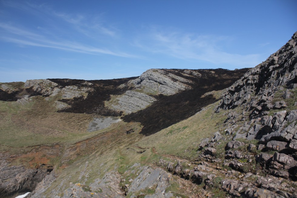
After walking a bit further I realised that off in the distance I could see Worms Head. This was quite exciting. The angle made the long narrow tidal island look like two small islands. It also gave me the idea that Worms Head was not that far away. Now, whilst this was very encouraging and cheered me, by the end the walk I realised that was nonsense. One lesson I learnt from this walk is “just because you can see it, doesn’t mean it’s close”. It has become my mantra. So on I went, buoyed by the mistaken belief that I was half way to Rhossili already.
Towards Worms Head
I think I had not bothered to look at my map in a good while because I was caught by surprise when the path headed up hill and inland. I was the first of many “Where the **** has the path gone” moments. When I walking on my own I chat away to myself (like a nutter). Mostly it’s encouraging stuff like “Come on” and “Let’s do it” when I need to get up a hill but its also less ladylike stuff when I get a bit lost and I can’t find the path. I just hope any near-by sheep are not offended. I also say hello to the sheep and lambs.
I found the path, it had moved inland. It was not at all close to the cliff top so I could no see the sea. Once or twice I tried to sneak a peak at the sea by wandering off the coastal path towards the cliff edge but I decided it was too much effort as I had a long walk to do I didn’t want to waste energy of detours. I also found lots and lots of Gower mud. It was a rather fantastic orangey brown colour.
As I walked along the cliff top I knew I was passing above places with wonderful names like Blackhole Gut, Yellow Top, Foxhole Slade and Paviland Cave. I could not see any of these places from the path. I have always wanted to see Paviland Cave but it is notoriously difficult to get too. It is where the so-called “Red Lady of Paviland” was discovered by the Rev William Buckland in 1823. This was a partial human skeleton dyed in red ochre. The Rev was a man of a times and decided that because there were parts of a necklace made of sea shells and ivory jewelry that this had to be a woman’s skeleton. Today we’d call him “old fashioned”, I think. It turned out that this not a lady at all but a young man and he was buried 33,000 years ago. This was back when woolly rhinoceros and mammoth roamed around what we today call Wales. Incredibly, it is the oldest known ceremonial burial in Western Europe. Sadly, there was no Welsh museums in existence when the “red lady” was discovered so the remains where taken to Oxford, where they still rest despite the fact that we have lots of museums in Wales now.
Eventually, I reached the point where the path crosses with the one from the village of Pitton. I came a across the first people I’d seen in maybe an hour maybe longer. They were having a break. They complained that the path down from Pitton was extremely muddy. I overtook them but I was starting to feel tired. I had been walking for about 2 hours no-stop.
I was just over half way through this walk. So I found a place amongst some rocky outcrops to eat my lunch. I watched some crows flying above the cliffs. For once I ate my banana first. I was really hungry. The cheese and pickle sandwiches and the chocolate biscuits all tasted wonderful. The outcrop called the Knave is nearby and I will continue the second part of my long walk to Rhossili next week.