I recently had the pleasure of donating a painting and three mounted prints to the NHS Annual Practice Supervisor/Assessor Team Awards for 2020. These awards are presented by the local NHS Education Team for nurses who have gone the extra mile to help student nurses. Many years ago I was a teacher who helped train the trainee teachers in our school, so I know how important the role of a mentor/trainer is in a practical placement. Training students can be incredibly rewarding. You are not only supporting a young professional at the start of their careeer, but also through training them, you are forced to reflect on your own practice. I also know from recent personal experience from being in Morriston Hosiptal with my broken leg/ankle just how hard all nurses work, especially the student nurses on their placements. I used to be fairly exhausted after teaching for 5 hours in a working day but nurses work an incredible 12 hour shift! So to find the time and emotional energy to fit in student training along with all their other duties is really deeply impressive. I also really valued the care, kindness and good humour they demonstrated to me and the other patients on that ward.
This year’s award ceremony took place, via Zoom, this week on the 25th November.
St Marks Nursing Home, Swansea, was the recipient of my oil painting “Coastwatch Station, Rhossili”. Nursing homes have had a particularly challenging time this year because of Covid 19, so I am really pleased that they have a new painting to cheer up the staff and patients.
Coastwatch, Rhossili, Gower
My three mounted prints of Three Cliffs Bay, Gower went to the Hafod Y Wennol Learning Disabilities Centre, Ur Ysgol Nursing Home, as well as to Martyn Morgan, who works in Mental Health. I am sure that they were all well-deserved winners and have played an important role in training and supporting our future nurses. Thank you!
Donated Prints of Three Cliffs Bay
You can buy prints of Three Cliffs Bay, Gower via Artmajeur.com here
Rhossili Bay is a vast beach. The beach is 3 miles long. Photos do not do it justice.
The 3-mile Rhossili Beach (tide out)
A number of landsmarks are frequently photographed (and painted) along this great expanse – Worms Head the tidal island that stretches along at the Southern end of the bay, the old rectory that looks out from the middle of the shelf above the beach and in the midst of the sand, the Wreck of the Heletiva. If you look very closely at the photo above you might just be able to make it out.
Need help? It’s the group of shark-like fins that are poking out of an impossibly small pool in the midst of the sand. The Helvetia sank into the sand over 130 years ago and only her stubs of her wood ribs remain.
From on top of the Rhossili cliffs, it looks tiny. I have only been down onto the beach to visit it once. It’s usually surrounded by people photographing it.
A quick online search will turn up many, many images of this wreck close up; some with shadows, others with reflections, lots with beautiful sunsets, and a few stunners with starry skies. I don’t know how they arrange it when more than one photographer wants to take a photo at sunset?
Selection of photographs of the Wreck of the Helvetia found online
She is surprisingly small. These remains must be just the “nose” of her bow. I am very taken with how organic she is. She is made of greenish rotting wood. Presumably being underwater for long parts of the day means that she is only rotting very slowly. Up close, the rotted bow looks dragon-like. The iron nails that protrude from the wood are like the teeth of the beast. The rust from the iron colours the wood orangey-red. Red and green, the colours of Wales.
Wreck of the Helvetia (detail)
I wanted to find out more about this ship. What did she look like before she sank? Did anyone die? Why was she called Helvetia?
I discovered that The Helvetia had been a Norwegian barque, which is a kind of sailing ship. She had been built in 1855 and registered at the port of Bremerhaven (in modern-day Germany). She had sailed from New Brunswick, on the East coast of Canada in late October 1887. Although the sea around the Gower coast seems tame in comparison with the wild North Atlantic off Donegal, the coastline has seen the demise of many ships over the centuries. The Helvetia was caught in bad weather and hit the dangerous sandbank of Helwick Sands. She was then swept around Worm’s Head and into Rhossili Bay. Her captain decided to drop anchor but the galeforce wind meant her anchor was ripped free from the sand and she was wrecked on the sands of Rhossili beach. Fortunately, no lives were lost.
Three-masted barque (image from Wikipeda)
During the following weeks, her cargo of timber was collected from the beach and gathered for auction sale. The wreck itself was sold to a local man, who intended to strip the precious copper keel from the vessel but before he got the chance, the Helvetia sank into the sand. Local legend says that he had to settle for salvaging the ship’s deck boards!
I tried to find a photo of the Helvetia before she sank and I discovered that there are many ships that have born that name in the past and in also in the present day. Here are some examples.
Helvetia is a popular name for ships
This got me wondering why Helvetia was such a popular name for ships. What did it mean anyway? So I did a bit of research and found out that Helvetia was the personification of Switzerland, like Britannia, is for Britain, Marianne for the French Republic, or Erin is for Ireland. So why were Norwegians naming their ship Helvetia? It seems I was totally on the wrong track here.
I did some research and I found that Hel is also an Old Norse word. It has several meaning. It could mean “Hel” who in Norse mythology was a goddess who ruled the underworld, Helheim, or Hel. Hel-Víti thus means “Hell-torment”. That would be a great name for a Viking ship, I think. Hel, however, also means luck which is possibly a better name for a ship, especially as sailors are incredibly superstitious people. If you made your living on the changeable sea you’d be very superstitious too. On a tangent, it was apparently customary among Vikings to say “hell og lykke” (luck and happiness) when they met. This is supposedly were English speakers get the greeting “hello” from.
Anyway, I had assumed that there was a rule that only one ship at a time could bear a particular name – like the Ark Royal, but it could be reused again and again. No so. There were many other ships in the C19th with the name Helvetia – more than one of these ships were passenger ships that took people who wanted to emigrate to the USA, another Norwegian ship, SS Helvetia spent much of the 1870s & 1880 steaming across the Atlantic from Liverpool to New York. Conditions must have been poor as there was a cholera outbreak on one of these voyages in 1866 and the ship was forced to return to Liverpool.
SS Helvetia
I found another Norwegian ship called Helvetia, operating across the Atlantic in this period. On the “Noway Heritage” website this ship is described as a Bark (Barque) like the Rhossili ship. This ship was also built in Bremerhaven, but in 1858 not 1855, and was wrecked in 1888, not 1887. I don’t know if this is the same ship as the Rhossili wreck. Quite possibly. There is an online passenger list for the Bark Helvetia from her 1861 voyage from Germany to New York here, and you can see the names of the framers and skilled-labourers who were looking for a new life in the United States. According to the “Norway Heritage” website, the Bark Helvetia also sailed to Quebec, in Canada, on a regular basis. She also sailed to Swansea twice in 1866. This Canadian link makes me think that it is the same ship. She regularly sailed from Norway taking hundreds of passengers presumably looking for a new life in Canada in the 1860s (you can see the passenger list here). Incredibly, between 1825 and 1925, more than 800,000 Norwegians immigrated to North America—that’s about one-third of Norway’s population! Most of them immigrated to the US, and lesser numbers immigrating to Canada. Hunger and poverty pushed them to leave their homes. The voyage must have been grim beyond belief. In 1861 a ship called the Helvetia, possibly not the Rhossili ship, is recorded as carrying 344 passengers in steerage from Drammen (Haagensen)but by the time they arrived in Canada, there had been five deaths. Looking at the other ships that arrived in Canada in that summer, smallpox, and measles were also rife on board the crowded ships. Deaths were not uncommon.
Later on in the 1870s the Helvetia sailed from London and then Truro, in Cornwall. I am guessing that she took English passengers to North America and brought timber back to Europe. This intrigued me. Distant relatives of mine left Scotland in the 1860s and started a new life in the States, setting up a successful business selling furs in snowy Des Moines, Iowa. Perhaps they traveled on a ship like the Helvetia? Interestingly, many Norwegians settled in Iowa too.
For a sea-faring nation, Britain has preserved precious few sailing ships from the past. The Helvetia (and her many namesakes) deserves to be remembered as one of the thousands of ships that played a role in the mass migration of peoples from Western Europe to North America in the 19th century. She may have met her end on in the sands of a Welsh beach, but she had been a workhorse of the North Atlantic and it was very fortunate that her final cargo was timber and not people. It seems very fitting that this Scandinavian ship lies on the sands of Rhossili Bay. As behind her off to in the distance another dragon, the Wurm, or Worms Head stretches across the horizon. Wurm is a Viking word. It means “dragon”.
The Wreck Of The Helvetia, Rhossili, Gower
Footnote October 2022
I was contacted by Sam Zhang who had an image of a model that was made of the Helevtia in her hayday It is a cut out from The Illustrated Times news paper in German, dated 6th August 1859. unfortunately the article it is for is cut out and most likely lost. I am very grateful to Sam for sending me this image.
Dylan Thomas, the poet, grew up in Swansea and he descbed it as “An ugly, lovely town … crawling, sprawling … by the side of a long and splendid curving shore”.
About 5 years ago I went through a phase of painting a number of intricate paintings of Swansea. I loved the layers of Victorian and Edwardian houses with their high pitched roofs. I went to great effort to walk out onto the quay and the beach to take photos with a zoom lens. The quay is no longer accessible, as part of the walkway has since collapsed.
I recently reworked a couple of these paintings that I still had.
The Old Observatory, Swansea
Over to Bernard Street, Swansea
I was recently commissioned to paint another painting from this series. The commissioned work would be similar, but the composition and the execution of the work would be slightly different. I had mixed feelings about the project because I knew how fiddly these paintings are. These paintings take a great deal of concentration! I use a small brush for all the work on the buildings and they take several days of very focused effort to complete. Still, I hadn’t painted one for many years so I decided to paint one again. Perhaps it’s like a transatlantic flight, something that you can endure once a year but no more often than that. So here it is.
Swansea from the Beach Revisited (2020 commission)
Still, for all my wingeing I can’t help but say that I was really pleased with the final painting. My head hurts from all that focusing on the small houses with their white gables and red chimneys. However, I did like thinking about the different places in the painting as I painted them. The perspective squeezes the buildings together in a way and makes them look closer to each other in a way they are not in real life, by that I mean, on the ground.
Beachfront café when it was 360
On the far right of the painting, on the beach, is what used to be the 360 Café and is now called The Secret. Next to that is the green building know as the Patti Pavilion, the trees behind it belong to the beautiful Victoria Park. They look so close to each other but in reality, the Patti Pavilion is on the other side of the busy Oystermouth Road.
Patti Pavillion and Oystermouth Road
The square building that stretches across the rest of the painting is the Guildhall, which contains the beautiful panels painted by Frank Brangwyn. Rising up behind these buildings is are the parts of Swansea known as Sandfields, Brynmill, and Townhill.
The Brangwyn Hall in Swansea.
Once upon a time, they were villages or rolling farmland, but now they are all merged into the sprawling City of Swansea. As Dylan Thomas aptly described it “The town of windows between hills and the sea.” On rainy days the clouds descend on Townhill and it can no longer see or be seen!
I am now working on a medium-sized much “looser” Donegal landscape painting, before making a start on two more commissions.
You can now buy a print of this painting here. Click on “reproductions” tab to see your options.
To follow in Dylan Thomas’s footsteps you can visit his favourite places around Swansea:-
While the rest of the world is on coronavirus lock-down I am confined to my bedroom with my leg in a very heavy plaster. Moving from the bed to a chair involves a lot of hopping and a zimmer/walker frame. It all takes a lot of effort to achieve simple things that I never gave much thought to before.
I broke my left leg. I have broken both lower bones and dislocated my ankle. Six days ago I had an operation to pin the bones in my ankle. My brother asked if breaking a bone is more painful than a toothache. The answer is definitely yes. I have endured 50 shades of different pain since I went for a walk with our dogs 2 weeks ago in my favourite woods, near Ilston, Gower. It was just about the worst time to break my leg, to be honest.
Ilston River (SOLD)
I had walked about half a mile along the side of the stream. I had bought a new camera with me and my attention was caught by the sunlight on a mossy tree. I decided I would move closer to take a photo. Instead, I stumbled over a muddy stick and as I put my left foot out to steady myself I felt it twist and a sickening snap. I rolled on the wet ground, hoping against hope that I hadn’t done something dreadful but the horrible pain told me that I had. My foot was bent out of shape. Just to think about it makes me feel ill, even now.
As I lay on the ground, I wondered what to do. I tried shouting “Help” a few times but felt silly/useless. What could I do? My husband was in Ireland. Fortunately, I had my mobile phone in my handbag and it was charged with credit so I rang for an ambulance and waited, and waited. The call handler told me not to move. It was cold on the wet mud. I took a photo of my bent leg. I have not looked at it since. I don’t think I can bear to.
Ilston Cwm – Close to where I broke my leg
I assumed that the ambulance would not be too long (I was very wrong on this score) and I started to worry about my two dogs, what would happen to them? I rang my neighbours Rob and Liz and told them what had happened and where I was. Rob said he would come for the dogs. So I waited. I lay and looked up at the sky. Blue patches and white clouds drifted by. It started to rain. Then the sun came out again. I was still lying on the ground. I don’t remember what my dogs were doing but they were nearby. I think Biddy, the collie-cross, tried to present me with a few sticks to throw for her. I clutched my injured leg, it really hurt. I rang my husband. It went to voicemail. “I am lying in Ilston Woods, I think I have broken my leg. I have rung for an ambulance. I have spoken to Liz and Rob. Rob’s coming for the dogs….” I felt bad about leaving him a message when there was nothing he could do.
View From the Bridge 100 x73 cm
After a long time, a family appeared on the track, a couple with their two girls. “Help, I think I have broken my leg”. I think they were surprised by this as they walked towards me very slowly. I told them that I had called for an ambulance and my neighbour was coming. They took my phone number and said they would go down to the road and look out for Rob and/or the ambulance. So they left me and I waited and waited. Company had distracted me from the pain in my leg and being on my own meant being with the pain. I rang my husband again and then Biddy started barking. It was Rob. Thank God.
“How long have you been lying there?”
“45 minutes. The Call handler said to stay where I was”
“That’s stupid advice. She can’t see your situation. You will get hypothermia. We need to get you up” So with great difficulty, Rob helped me up off the wet mud and I hopped in slow agony to a mossy tree, where I first leaned against a trunk and later sat on a low branch. He had brought a heavy hi-vis coat which he put around my shoulders. It was blissfully warm.
I wish I could say that was the end of it. That the ambulance came soon after but they didn’t. We waited and waited and rang the ambulance again. It was difficult explaining where I was to call handlers who were not local. They wanted to know the name of the church at Ilston. Ilston is the tiniest of Gower villages. There are about 10 houses. There is only one church. What did it matter what saint it was dedicated to?
So after another long wait, I asked Rob to walk down to the house opposite the church at Ilston to ask them to ring the ambulance, perhaps they would be able to give better directions. We had often passed the people who live here, they waved in a friendly manner and I was hopeful that they would help. Rob left with my two dogs, Biddy and Mitzy, in tow. I sat and waited. The pain was worse when I did not have any company to distract me. I looked at the mud by my feet. I was dimly aware of a robin on a branch a few feet away from me. And then like a miracle, little Mitzy appeared by my side. She was collarless. I was so glad to see her. She was not leaving me. Good loyal rescue dog to the rescue. I took her photo as a distraction from the pain.
Mitzy the faithful rescue dog, to the rescue.
Rob returned with David (and Biddy on her lead). David is 73 and lives in the house opposite the church. He made several trips along the track, and brought me many very welcome items like a big blanket, gloves, hat and a hot water bottle. I was really thirsty and he also bought a bottle of water but David’s wife had said I could not drink anything, her advice turned out to be right, so I just washed my mouth out with it. He made several trips. The last one in the dark with a torch. He took quite a risk, helping us in the dark. We got excited because the beam of his light reflected in the stream and it looked like two people were coming along the track, but it was just him. It got very dark, The moon came out and a barn owl hooted. We told him to go home, we were worried about him in the cold night air. He reluctantly set off.
I started to think that no one was ever going to come. I was so cold. It would be difficult enough to get me out of here in daylight but in the dark? I kept thinking up with ideas for getting how to get me back to the road; What about a horse? A wheelbarrow? One by one my desperate ideas were politely considered and sensibly dismissed. Rob was a reassuring presence. They will come he said. Then eventually, Rob said, says, “I think I can see lights along the track, more than one!”
At long last, the ambulance service had come. After 5 hours of waiting. Two figures dressed in green, a woman and a man, carrying torches were coming along the path, with David and his brother-in-law leading the way. I was so relieved. Once they were there, I knew they could sort everything out. And they did. Lyndsey the paramedic was lovely and reassuring. She worked under very difficult circumstances. It was dark and very cold. She checked my blood pressure, temperature and although I felt so cold my body temperature was normal (hurray for thermal vests, I say). I was given a small dose of morphine which had me seeing stars and then liquid paracetamol. They called Sketty Fire Brigade to put me on a stretcher to carry me half a mile down the track (and over the church fence) to the waiting ambulance. It was a long journey looking up at the cold frosty stars through the tree branches from that stretcher. It was a full moon. They carried me wordlessly. There was a short snort of laughter when I said “Well Done” after they had hoisted me over the churchyard railing.
Ilston Church Yard
It was a very long night. The journey to Morriston Hospital Hospital seemed slow. Where are we now? I would ask. It was the pain that made it feel that way. We waited outside A&E in the ambulance for quite a while. Lyndsey told me her mother was the first baby born in the NHS and called was Aneira, after the Welsh founder of the NHS Aneurin Bevan. Eventually, I was taken in for my first X-ray. I was visited by a number of doctors who introduced themselves to me by their first names; Jeremy, Mohammed, Chris there were others but I have forgotten them. After a wait, the doctors in A&E manipulated my leg (I was under light anesthetic) and put it in plaster so that the agonizing swelling could start to go down. The leg was X-rayed again. Everything was aligned nicely. Every now and then the average waiting time in A&E was announced on the loudspeaker. It started at 8 hours, later it was 13 hours and then by lunchtime the next day it was down to 2 hours. I lost track of time. I didn’t get much sleep in A&E. It was a fascinating place, very hectic. No wonder there are so many drama series set in Emergency Rooms & Casualty Departments.
Anyway, to cut a very story short I waited a day for a bed in the trauma ward. I then spent another 7 days waiting for the swelling to go down so the ankle could be pinned. I was “nil by mouth” for 4 days in a row but never made it to the operating theatre. Thankfully, on Monday I did, finally. It was probably just as well as the ankle specialist was working that day. The coronavirus emergency meant that the ward was rapidly cleared, as they needed the beds and staff elsewhere. I was sent home on Tuesday via Red Cross Ambulance.
All through this experience, I have been impressed by the kindness and amazing patience of medical staff as well as just how much pressure the NHS is under. The pressure has just intensified ever since. I would like to thank Rob and David in particular, who waited so long in the cold with me, and Liz and David’s wife, and anyone who I came in contact within A&E, Ward A (which then had to move upstairs to become Ward G), the operating theatre and the Red Cross. Thank you xxx
Postscript:- Biddy and Mitzy went home with Rob and slept all the next day. Seamas flew back from Ireland on a plane full of racegoers heading for the Cheltenham Races.
Today is International Women’s Day. As I drove through Mumbles yesterday afternoon I was reminded of two remarkable Swansea women and I was pondered on why we like to focus on very unsual women, rather than remarkable ordinary women. It got me thinking about other notable women of Swansea, past, and present
Here’s my list of five that came to mind:-
First comes the women of privilege:-
1. Thereza Dillwyn Llewelyn (1834 –1926). She was an astronomer and pioneer in scientific photography. She came from a wealthy family and her father was a pioneer photographer, astronomer, a botanist and a Fellow of the Royal Society. She made some pioneeringtelescopic photographs of the moon in 1857/8.
2. Amy Dillwyn (1845-1935) – She was a radical novelist, feminist campaigner, and early female industrialist. Amy was first, a novelist, and a supporter of sexual equality and women’s suffrage. When her brother and father died in the early 1890s she found herself responsible for a workforce of 300 and a spelter business crippled by debt. Impressively, despite losing her home, she decided to run the business herself, which she did successfully. She was a strong supporter of social justice and in 1911 gave her support to 25 striking seamstresses, who worked for Ben Evan’s, a local department store. These dressmakers were demanding a living wage in return for their long hours. Amy called for a boycott of the store and encouraged her friends and family to not shop there. Her eccentric appearance, her habit of smoking cigars and lifestyle make her appealing figure to modern eyes.
Now to some working women.
2. Jessie Ace and Margaret Wright (neé Ace) these two sisters were the daughters of the Lighthouse Keeper, Abraham Ace. In the winter of 1883, these two sisters valiantly rescued two lifeboat crewmen, in the midst of a terrible storm, by tying their shawls together to use as a rope. Margaret supposedly exclaimed: “I will lose my life than let these men drown” as she waded into the icy waters.
4. Iris Gower (1935 – 20 July 2010)- This was the pen name of Iris Richardson a prolific novelist who wrote many historical romances set in this area. I once heard her talk about her writing and was left with the impression of a resilient, hard-working woman with fiery red hair, who was a force of nature. She talked about her early days of writing, about getting up before her 4 children to write, before going to work! I don’t think she ever let up, writing about 35 novels and many articles too.
And finally (as I drove down Mumbles Road and passed her beautiful house on the hill) I was reminded of
5. Bonnie Tyler – who I once saw in Sainsbury’s on Christmas Eve several years ago. She looked very glamorous holding her wire basket in the tea and coffee aisle. I don’t think I have ever looked that glamorous, probably not on a night out and certainly on a trip to he local supermarket. Bonnie was the daughter of a coal-miner and grew up in a council house and left school with no qualifications, but talent and a lot of hard work led to a phenomenally successful musical career. Her two singles “It’s a Heartache” and “Total Eclipse of the Heart” are among the best-selling singles of all time, with sales in excess of six million each.
It’s hard not to focus on exceptional women like these. Often, we end up focusing on unusual people because we know more about them. There are newspaper articles, books, and photographs of them. I cannot find an online image for the “Ben Evans’ Girls” who went on strike in 1911. Those 25 striking seamstresses that Amy Dillwyn supported, would have been just as hard-working as Amy was, but lacking in the advantages her privileged upbringing and family connections had given her.
Ben Evans, Swansea
Interestingly thousands of Swansea people attended a mass demonstration in support of their cause. I could not find out if they had won of lost their cause for a decent wage. Iris Gower’s fictional women, may have been romanticized, but their hard lives were real enough. So here’s to all the women of Swansea (and everywhere else) the world, past and present, famous, infamous and obscure!
A year’s a long time in art. When I look back at my paintings from early 2019, it feels like I made them much longer ago than that! This selection of “popular” (most likes/biggest reach) is based on my Instagram account, there are many more images that I shared on Facebook, that were also popular but are not included here. The work in progress photos are often very popular, sometimes they are more popular than the final painting!
The most popular nine posts/paintings are all of Donegal, Ireland, paintings.
A selection of some of my most popular Donegal paintings from 2019
Here are my most popular posts/paintings of landscapes, people and animals of Gower, Wales and Stroud, England.
Some more of my most popular paintings from 2019
Finally, a selection of commissioned work. I particularly enjoyed painting the beautiful Maine Coon cats, especially as pet portraits are usually of the canine variety!
Selection of Commissioned work from 2019
My personal favorite from 2019 is this one. There is something about the neatness of the houses on the island that I relish in this painting.
Owey in Spring
Of course, the irony is that one of my most popular posts of 2019 on social media was not a painting but a photograph that my husband took on the spur of the moment of us in woolly hats (and my new Donegal jumper) on Christmas Day!
Seamas and me!
Here’s wishing everyone a Happy, Healthy and Prosperous 2020!
Here’s a footnote to Sunday’s post about waiting for gaps in the clouds. The sun was peeping over the top of the three peaks, illuminating the edges beautifully. I particularly liked the way the sea and the river, Pennard Pill, merge here. It’s not clear where saltwater and freshwater meet.
I used to like painting landscapes and cityscapes with clear blue skies. I waited for the bright sunny days of early summer to walk around, taking photos and looking for inspiration. Thus, my series of urban minimal paintingsof Swansea, made the town look a bit like a Mediterranean location!
What a joke. It rains a lot in Wales. It has rained incessantly for the past two days. Since my extended visits to Donegal, however, I have become increasing inspired by cloudscapes and the silvery light along the Atlantic coast. With my “new eyes” I have started waiting cloudy days in Wales to go out looking for inspiration. Not overcast days, but days with patches of blue sky and sunshine.
I drove down to Pennard, with the idea that I wanted to paint Pennard Pill, the river that follows into the sea at Three Cliffs Bay. The BBC forecast claimed that it would be sunshine and clouds all morning. When I looked at the Mumbles and Caswell Bay webcam, one showed sun and the other was overcast. I set off, anyway. I would go for a walk, regardless. On my way there the sun came and went. As I drove past Mumbles head, I could see it swathed in a light misty cloud. I wondered whether there would be anything to see when I got to Pennard.
Thankfully, the sun was shinning at Pennard as I made down the path that runs alongside the golf club. The tide was coming in and I could just see Great Tor in the distance, through the peaks of dunes. When got close enough for a clear view the sun promptly went in! I looked up at the sky and looked for blue patches. There were quite a few. So I carried on towards Pennard Castle, which is situated on the top the of the high dunes, further inland. I hoped the sun would reappear by the time I got to Pennard Castle. I tried to work out which way the clouds were traveling. Usually, they move from Oxwich Bay towards Three Cliffs. Today they were going the other way. The sun came out a few times on my walk. Just as I was climbing up the sandy path the castle I came out and lit everything up like a technicolor Hollywood film!
Pennard Castle
The sun promptly went in again. I stood in the ruins of the castle and waited. I thought about the fairies who had supposedly destroyed the castle with a sandstorm when the lord of the castle had refused to invite them to his wedding party. Eventually, the sun broke through and lit part of the valley below.
Pennard Pill
I watched the light move across the valley and the colours burst into life.
Pennard Pill in sunshine
I then decided to walk back towards the sea and see if I could photograph the three peaks that give the bay its name. The clouds rolled in.
Clouds over Pennard Golf Course
I would have gone home at this point, as there was a cold wind and it was almost lunchtime but I could see bright light off in the distance. It was on the far side of the Bristol channel. I could see a ship on the horizon lit by this light.
Ship on the Bristol Channel
How wide was this stretch of water? Miles. How long would it take for that shaft of sunlight to make its way over to the Gower coast? A while. So I waited. I am not very good at standing still so I walked around a bit, watching the dog walkers and small family groups vanish from the landscape.
The clumps of large mushrooms spotted about the grassy parts of the dunes, made me think of the fairies again.
I climbed dunes, trying to decide good locations for photos for when that shaft of sunshine arrived. It was definitely coming my way. A new set of walkers was arriving on the beach. They were all optimists too!
Cloudy Three Cliffs Bay
Hunger was starting to make itself known. I slouched down against a dune. Patience. Patience. What was the point of giving up now when I had waited so long? Impatience comes from wanting to be somewhere else. I needed to be here now. I thought of a line I heard Van Morrison sing at his 2015 Live 70th Birthday Concert at Cypress Avenue, Belfast “It has always been now” (52 mins into the clip). He’s a genius. He captures the joy of being truly present in the moment. Just as I was saying that to myself when the sun arrived and the technicolor lights were on!
The three peaks
That doesn’t quite capture it. Here let me show you. My view of the world.
A Gap in the Clouds (SOLD)
That’s more like it.
Now I could go home and eat lunch. Paint and listen to Van Morrison.
I managed to make it down to Rhossili Bay this week. It has been raining on and off for weeks. I have been painting in my attic studio listening to the rain thundering down and I have got quite tired of that sound. So when I was greeted by clear skies I decided, on a whim, to drive down to Rhossili to see the autumn colours.
Rhossili has a wonderful windy wildness to it. It’s unlike the rest of the Gower Peninsula. The trees all lean heavily away from sea and the prevailing westerly wind. As I drove into the village I was caught up in a sheep-jam. A herd of sheep was being moved from one field to another. They were packed into the little road and had stopped the traffic (it was three cars actually). I watched the mob of sheep as they swirled in front of my car and past me. They were Welsh Mountain sheep; only a few had horns. Their creamy fleeces were spotted with brightly coloured red and purple “smit” marks. These are marks painted by their farmers that denote ownership. One moment they were packed around me and the next they had moved on.
There was space in the church car park so I parked and put my donation in a slot in the wall. This car park is closer to Rhossili Beach. If I had wanted to walk to Worms Head itself the National Trust Car park with its facilities (loo block and shop) would have been better. From here I walked down a stepped concreted path down towards the beach. It seems strange but I have never walked on this particular path before. I don’t know why. I have always walked parallel to the beach along the cliffs paths (one on the top of the downs and one in front of the rectory). I wrote about the coastal path in several blog posts and in my book, Footnotes: An Artist’s Journey Around the Gower Coast.
Rhossili Bay (View From the Path)
So I followed the path downhill and got a different view of the Worm. The bracken had died back to a wonderful russet colour (one that I associate with wales) and the sea was a beautiful turquoise blue. The tide was out and the tidal island, the Worm (Wurm) rose up above the waves on the horizon. I looked at how the light caught the back of the Dragon and remembered how arduous walking across it was.
Over to Worms Head SOLD
The walk down to the sea was quite steep but easy. The final descent was down a ramp of gravel. The vast beach was surprisingly populated for a term-time day in the week.
Worms Head Rhossili
Of course, I could not pass up the opportunity to visit the remains of the Helvetia on Rhossili Beach. The Helvetia was a Norwegian ship bound for Canada that was wrecked in south-easterly gale on Rhossili Bay over 130 years ago on 1st November 1887. In the Instagram age, given its picturesque location, its not surprising that it has been photographed and shared countless times.
The Wreck Of The Helvetia, Rhossili, Gower SOLD
I walk across the beach to bottom of the vast 200-foot cliffs, looking at the colours and light. There are seagulls scattered across the beach and when I turn back I can see the Rhossili Downs and the Od Rectory reflected in the outgoing tide.
Rhossili Reflection
On the far edge of the beach, I was surprised to discover the remains of another shipwreck in the sand. A bit of online research and I discover that this is Vennerne, apparently, it is known locally as the Vernani, and it was dashed to pieces under the Rhossili cliffs in 1894.
Another Wreck on Rhossili Bay
There is quite a strong breeze. When the clouds roll in it starts to feel cold. The clouds create a softer light. The grays and purples dominate. I am glad I have my woolly scarf on and start to make my way back to my car. The path hill is pretty steep and the climb warms me up.
Cloudy Worms Head
The next day, I am tired from walking across the sand but it doesn’t matter as its raining again.
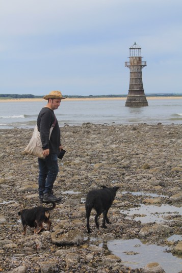
It was a long walk to the lighthouse at Whiteford Point on the northern tip of the Gower Peninsula. The last time I walked here, I just looked at the lighthouse from the beach. This time I wanted to get up close. We had left it late and the tide had already turned when we got here. The last stretch to the lighthouse is across lots of slippery, small rocks were surprisingly difficult to walk across. It took a good 20 minutes to make our way across them.
I was accompanied by Seamas, myy husband, and our loyal dogs, Biddy and Mitzy, who were not keen on the rocks but will follow Seamas anywhere.
Seamas (in hat) and dogs at Whiteford Lighthouse
The iron victorian lighthouse had cormorants perched on it when I got there (ahead of the others) but a motor boat came past and they all flew off!
Birds flying away from Whiteford Lighthouse
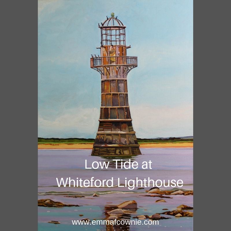
Here’s my painting. I love the colour of the rusted iron of the massive thing and the sea-life that clings to the lower half. It was a hazy day so the sky is bluish and the sea has a slight mauve tinge to it. The waves are gentle but advancing.


")