We have been exploring Malin Head a fair bit recently. I really enjoy it’s wildness and dramatic beauty. It’s one of those rare places that is quiet. By quiet, I mean a lack of human busyness. There’s plenty of nature noise like the wind, the hissing of the grasses and leaves as they are blown.This has to be one of the most exposed spots in Ireland.
There is good scattering of robust cottages and relatively few cars. The narrow, winding roads mean that they are not pelting by. Its the quiet and still I hunger for – even when its blowing a gale! The fresh air here is like a refreshing drink of water.
Here are two new Malin Head paintings. The first is “Midsummer at Malin Head” which is a sturdy cottage surrounded by vigorous growths of monbretia. We are a bit early for its distinctive firey orange flowers – the come out from July to September.
The second painting is John’s Cottage, Malin Head (photography with permission of John Gallagher). John was born in the cottage but he now lives with his family (and dog) in a neighbouring cottage a stone’s throw from here.
In the distance are the Urris Hills, also on the Inishowen Peninsula. We spent two days last autumn there, looking for my husband Séamas’s drone crashed on Croaghcarragh (a peak between Urris Hills and Mamore with Mamore Gap in between) after he flew it backward into the mountainside! I spent a longtime waiting for him as various spots on the mountain, looking out towards Dunduff, Clonmany and Malin. The view was magnificent in that direction too. The howling gale that threatened to blow us off the mountain was pretty sobering. Fortunately, the drone was found and it still worked after a night out in the wilds. DJI make pretty tough little drones!
This is a postscript to my post earlier this month about Malin Head. It was a beautiful sunny day there today. Summer has arrived in Donegal. Who know how long it will last so everyone was out!
I met brothers Harry and Kit (Dr) Lawrence just after they had laboured up the steep hill to Malin Head Tower on their bikes, laughing as they finished.
“We have just finished a thousand km cycle ride from Mizen Head!” Annouced Harry to no one in particular and anyone who could hear.
“Congratulations” we said and I shook their hands (me and some motorcyclist tourists).
The brothers had taken just 8 days to ride from Mizen Head in Cork to Malin Head today. I told them about Sophie Powers who had done it in 4 days with very little sleep. They had had sleep and no back up team. Just two panniers with their spare clothes in. They were not expert cyclists. Kit proudly told me that he’d bought his bike on Gumtree for £100 last month. It was clearly a massive bargain as it did the job very well indeed. They raised over £2000 for the Samaritans. I couldn’t have done that in 80 days never mind 8 days! Well done!
Just arrived at Malin Head
Harry and Kit Lawrence at Malin Head with that bargain bike
The name will be familar to British ears who ever listened to the daily shipping forecast on BBC Radio. It is broadcast late at night just before 1 am and very early (5.20am). Anyone who is a night owl or insominiac will have listened to it. The list of shipping zones and forecasts is not only practical but also poetic and rather mysterious. Following the litany of locations and numbers is very soporistic. Listen to the clip below. The actual broadcast is from 2.46 onwards ZZzzzzzzzzz
Shipping Forcast (1993) – almost always broadcast on the radio, you have to use your imagination!
Many British people may not know where Malin Head it is anymore than than they know the location of German Bight or Viking. To Irish ears, however, it is well-known as the most northerly tip of the island of Ireland and also features on Met Eireann’s, sea area forecast, broadcast on RTE.
UK_shipping_forecast_zones
Malin Head to Mizen Head
People regularly tranverse the length of Ireland from Malin Head, Donegal, to Mizen Head, Cork. It’s a fair stretch. Just under 400 miles (640 km). Some incredible people have cycled it in just over 15 hours. Ordinary mortals take about 4 days.
Amazingly some super-human runners have done it in about the same time – 4 days! I recently listened to a radio interview with the heroic Sophie Power. Sophie is from England and she recently ran the length of Ireland in under 4 days. This is a World Record. She beat the previouis record by three hours. Being a mother, she had to fit it in during her children half-term holiday and didn’t get to pick the day with the nicest weather – just the Tuesday of half-term and so she started off in driving rain! Many years ago I used to run (only piddly 10ks and 5ks) and I would certainly prefer to run in rain than heat.
Incredibly Sophie ran most of the distance without sleep, snatching the odd half an hour on her second and third day. She ended up hallucinating, and with a knee injury that had to be braced. When she finished the race in Cork she had developed heat stroke! That alone shows you how far south Cork is. There’s no way she’d get heat stroke in Donegal! She’s planning to come back and run the Cork Marathon.
Sophie Power at Malin Head
At the Edge of the world
Standing at Malin Head is like standing at the edge of the world. To the north is nothing can be seen but sky and sea. A long way off is Iceland and much. much further away to the north-west is North America. It feels very remote (but surprisngly accessible from Letterkenny and Derry/Londonderry) but to fishermen and sailors, I’m sure it’s not. Scotland is surpisingly close to the north-east. If you have ever flown from England to Belfast on a clear day, you can see the Scottish Isles and the Isle of Man scattered across the Irish Sea, pretty close the Antrim coast. Donegal is just a bit further along.
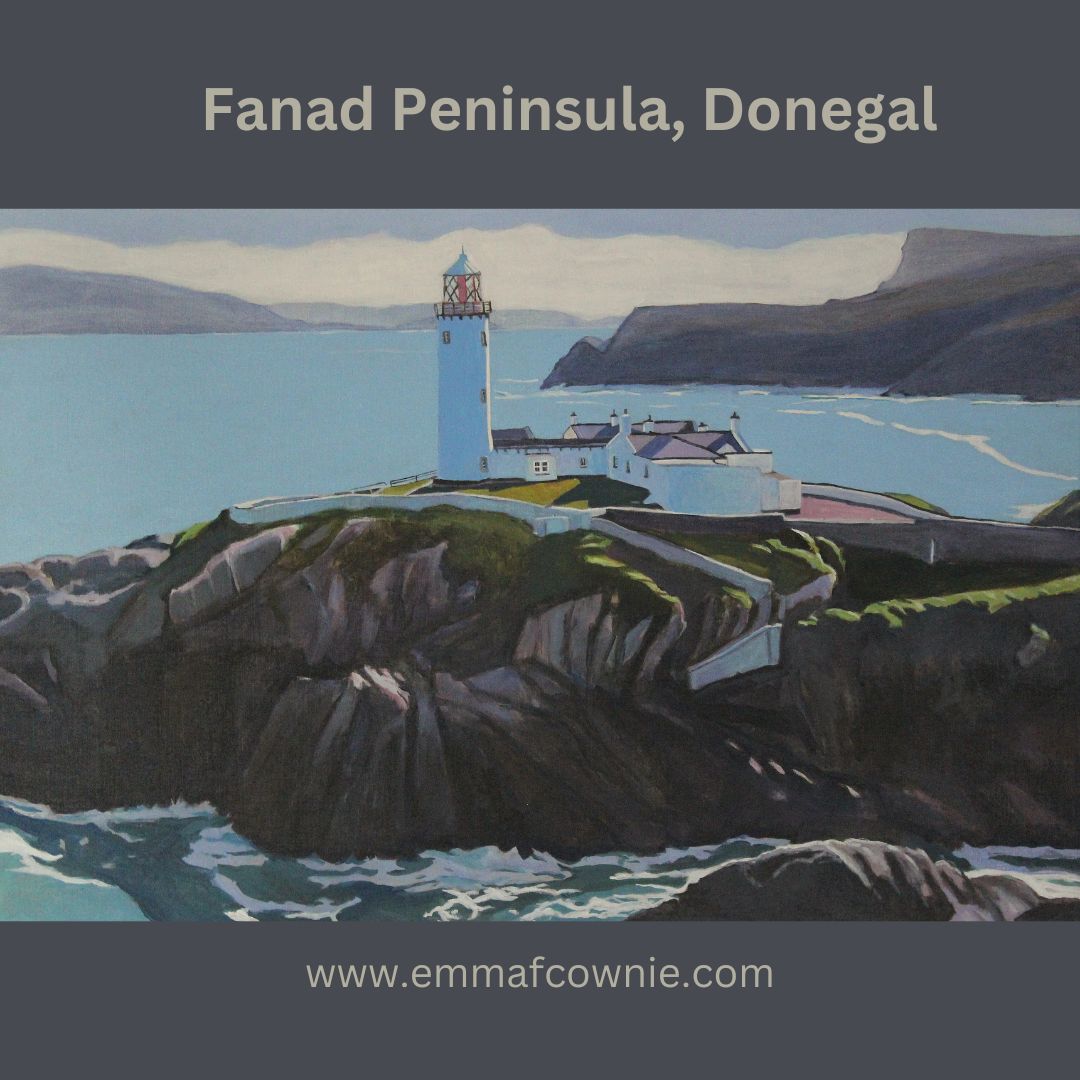
On the most northerly tip of the island of Ireland, you will find a tower that was built in 1805 during the Napoleonic wars as a lookout tower to defend against any attacks by the French. You can see at the top left hand side of my painting above. Edges of places are places to look out from – for invaders, or for incoming storms. Weather reports that were important to local and international shipping were first recorded at Malin Head in 1870. It was in that year the tower became a signal tower for Lloyds of London. Semaphore was used to connect with ships at sea and the lighthouse on nearby Inishtrahull. In 1902 the first commercial wireless message was sent from Malin Head to the S.S.Lake Ontario by the Marconi Company.
Divers’ magnet
There are the wrecks of many ships lying off the coast in this area. Many of these such as SS Audacious, SS Carthaginian and RMS Justicia date to the time of the First World War, when Ireland was still part of the British Empire.
In 1917 two German mines sankLaurentic and although her crew successfully abandoned ship, but 354 of them died of hypothermia in her lifeboats.Interestingly, Laurentic was carrying about 43 tons of gold bars when she sank. Most of the 3,211 bars were salvaged by 1924; three more bars were found in the 1930s, however 22 gold bars have still not been recovered.
The Great Emergency/Second World War
During the Second World War, Ireland was neutral. The Irish army built lookout posts in places along the coast to prevent any violation of this neutrality. This was important as this part of Donegal is so close to Northern Ireland, which not not neutral and was bombed by the Germans. There is an EIRE 80 sign built of stones during the war so aircraft would know that they were over Ireland (not Northern Ireland). They acted also as a navigational aid for pilots. Eire 79 is at Fanad Head to the west. Eire 81 is at Glengad Head, further along the Inishowen Peninsula, to the east. You can see it on the map below. The SS Athenia, a passenger ship carrying 1,418 people was torpedoed by a German U-boat just hours after war had been declared in 1939 off the coast of Malin Head! Most of the passengers survived but 117 perished.
Tourism Sign at Malin Head
Some scenes from the film Star Wars: The Last Jedi film was shot at Malin Head. I have to admit that I am not a Star Wars fan – I never made it through awhole film. I have to admit that I’m more of a Star Trek fan. Apparently, it is possible to have a tour of the locations used for the film from local tour guides. The road leading up to Bamba’s Crown has been renamed locally from the R242 to the R2D2 in recognition of the Star Wars connection. Also beside the tower, there is a short lovely refreshing walk along the cliffs to Hell’s Hole. The cliffs are massive here and even on a relatively calm day the sea is restless and a bit intimidating It needs to be remembered that this not just a sea here but an Ocean.
Birds Eye View of Malin Head, Donegal- Emma Cownie
Fanad is a finger of land that lies between Lough Swilly and Mulroy Bay on the north coast of County Donegal, Ireland. It is not that easy to get to and the the survival of the Irish language is testiment that relative isolation.
Lambing season at Fanad Head (Donegal) SOLD
Fanad Lighhouse (Donegal). Is one of the 12 Great lighthouses of Ireland. It was built in 1886 at Fanad Head (although the station was originally established in 1817). The lighthouse, or more acrrately, the harbour light, marks the entrance into Lough Swilly which forms a natural harbour.
Fanad Lighthouse (Donegal) SOLD
I have painted this isolated structure several times before. I have always enjoyed painting the northernly light on Fanad. I have only have painted it in acrylics. That’s not a delibertae choice, more one of circumstance because at times I have had limited space, and I dont want to use oil paints with kittens close at hand.
Over to Fanad Lighthouse (Donegal) _Emma Cownie SOLD
I think acrylics suit the airiness of the subject matter. After a couple of years working out how to use them, I have settled on a technique of light layers of paint that allow the underlying colour to show through. This can give a transulent quality to the colour. This is in contrast to the relatively flat areas of colous I use for the larger areas of colour such as sky or the sea.
My latest painting was an experiment in composition. We used an image from a drone shot done by my artist husband, Seamas (James Henry Johnson).
In this piece, I wanted to create a sense of space from the mountains of the Inishowen Peninsula in the distance. The distant mountains were layered with bluish white until I got the right impression of distance.
I often find myself looking at the tiny Fanad lighthouse far off in the distance when I am at Lisfannon on the Inishowen Penisula. There is a sign comemorating a famous Atlantic storm that happened in 1748. this storm threatened to sink The Greyhound, the ship of one John Newton, a slave trader. John was so frightened that he called out to God for mercy. This moment marked a profound spiritual conversion, and many years later he wrote the words for the hymn “Amazing Grace” one of my favourite hymns, and to also campaign for the abolition of slavery.
There is some confusion how many storms there were . One website claims the terrible tempset happened far away out in the Atlantic because it took John Newton another four weeks after his conversion to sail into Lough Swilly and arrive at Derry/Londonderry. The Amazing Grace.ie site however, makes it clear a second storm happened in Lough swilly itself as it quotes John’s journal ” We saw the island of Tory and the next day anchored in Lough Swilly in Ireland. This was the 8th day of April, just four weeks after the damage we sustained from the sea. When we came into this port, our very last victuals was boiling in the pot; and before we had been there two hours, the wind began to blow with great violence. If we had continued at sea that night in our shattered condition, we must have gone to the bottom. About this time I began to know that there is a God that hears and answers prayer.” It’s got to be said, that John Newton really took his time putting his evangelical beliefs into action because he went back to being a slave trader for another five years before he eventually retired and became a minister in 1757!
The heaving sea at the foot of the massive lighthouse rock intrigued me. The Atlantic Ocean has such a bulk and stregth, even on a relatively fine day, I am not surprised that John Newton was terrified by its strength far away from the Donegal coast. I wondered about the long and difficult process of building this structure all those years ago in a remote location. Yet, this lighthouse has stood the test of time and proudly marks the entrance to Lough Swilly and can be seen from inland and further along the coast.
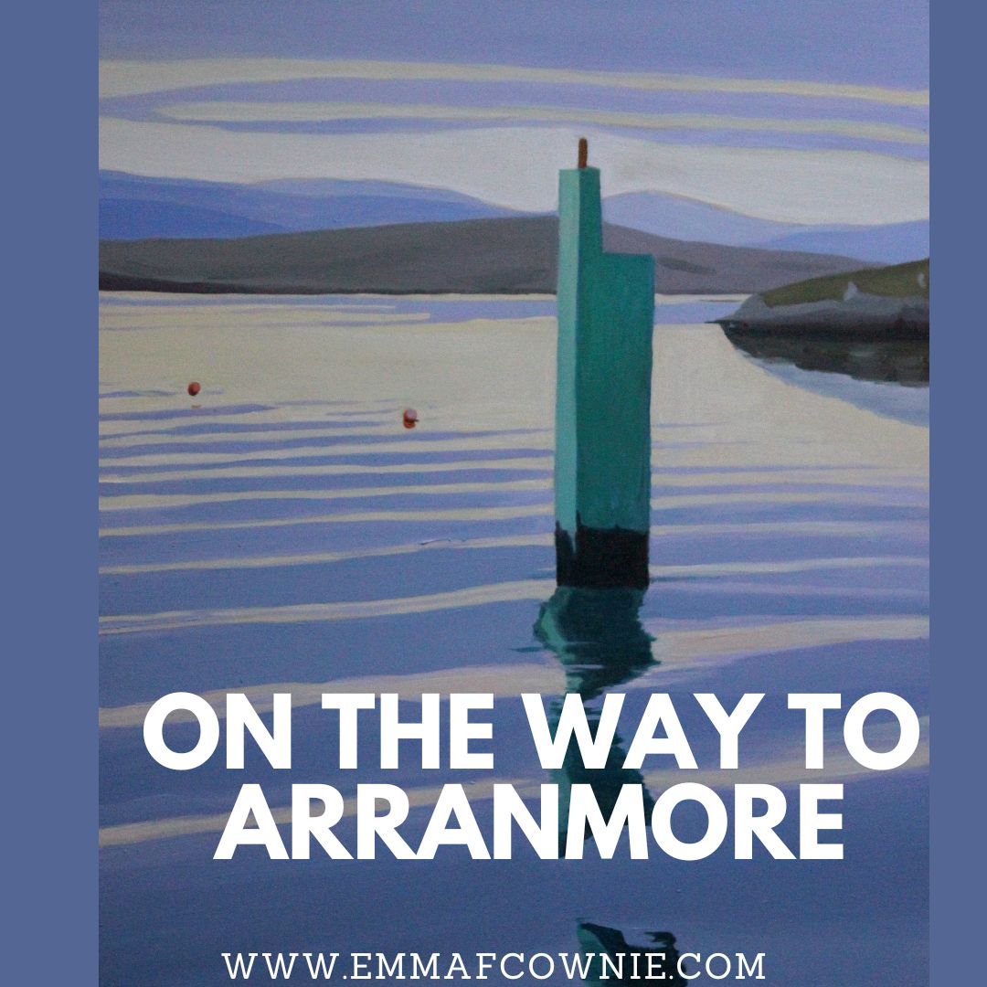
Looking through my recent work, I was surpised to realise that I haven’t painted many paintings of Arranmore Island in the last couple of years despite visiting the islands in the summer. So I have put that right with a series of new paintings.
As always I am entranced by the journey to and from the island. You can read my short History of the Island here
Arranmore is lucky to be served by two ferry companies. There is The Arranmore Ferry (Blue) which is based on the island and Arranmore Ferry (Red) which is not. Yes, I know the names are almost identical, just a small matter of “The”. They both offer a fantastic 15 minute journey from Burtonport (Ailt An Chorráin) to Arranmore Island. On a calm and sunny day the view on the crossing are just heavenly. Sometimes there are dolphins too.
Map of Arranmore and the coast off Burtonport
The ferrys sail through a narrow passage past a scattering of islands on the way to Arranmore.
Rutland Island (Inis Mhic an Doirn) lies between Burtonport and Arranmore, Donegal. William Burton Conyngham (a local landowner for whom Burtonport takes its Anglised form) had warehouses, a street of houses, a post office and a school built c. 1784 to capitalised on a the abundant herring fishing. Unfortunately, the herring disappeared very early in the 1800’s and the station fell into disuse. The island was inhabited until the 1950s. These are the remains of the fish factory and landing stage on Rutland Island.
Opposite is Inishcoo Island with Mount Errigal in the distance peeping out from under the clouds. The jetty in the left hand corner belongs the magnificent Inishcoo House (see painting below)- once a coast guard house, built in the C18th.
Inishcoo House, Ireland (SOLD)
There are several tiny holiday homes dotted across the islands (and cows)
Ferry Home (Arranmore, Donegal) by Emma Cownie SOLD
A you can see the views are quite idyllic. Whether from the ferry or from the island. To be honest, I wish the ferries were like the Circle Line on the London Underground, where you can ride the tube rround and round (it takes and hour and an half apparently, I have never done it) and you could ride them back and forth to the island all day!
Washing Line, Arranmore by Emma Cownie SOLD
Some more recent works….
A Home on Arranmore, West Donegal, Ireland by Emma Cownie
We visited Ramelton several times in this summer. It is a fascinating and historic town tucked away in the north-eastern corner of Donegal. Ramelton, (Irish: Ráth Mealtain) is also known as Rathmelton, this caused me great confusion when map reading. Yes, we have a sat nav but I am an old-fashioned girl and I like the immediacy of the map book. I thought Ramelton and Rathmelton were two different places. It is also not too far from another village called Rathmullan. I got very confused. We also didn’t know how to say the name properly to ask directions; we put the emphasis on the first syllable “RAMelton” but it’s said “RamELton”, if you look at the Irish Ráth Mealtain (bearing in mind you don’t say “th”s in Irish) it makes more sense.
Rathmelton/Ramelton
Bridge over the River Lennon in Ramelton (wikipedia)
Ramelton is a pretty and interesting place to visit. We entered from the north end, over the narrow stone bridge that crosses the flat, slow-flowing River Lennon. There are many fine Georgian-era houses to look at. The Mall runs along the south side of the river from the Bridge to Gamble’s Square. We enjoyed a very pleasant walk along the Mall towards the old buildings that form the Quays.
The Mall, Ramelton_Emma Cownie
Gamble’s Square, Ramelton – Emma Cownie
Ramelton, Donegal – looking towards the Quays – Emma Cownie
Further to the east lie the the Quays and the old warehouses, once commercial buildings, some of which are quite neglected, once formed the historic commercial centre of the town.
Old warehouses, Ramelton Quay – Emma Cownie
The town was founded in the early 1600s as a plantation settlement, on the site of an O’Donnell Castle by William Stewart of Ayrshire. Stewart was professional soldier (in otherwords, a mercenary) who had fought for kings of Sweden and Denmark before coming to Ireland for James I (VI of Scotland). He built and gave his name to fortications at Fort Stewart and Newtownstewart. In 1623 he was made a baronet and granted the castle of Ramelton, becoming the biggest landowner in the town. He also gained valuable fishing rights on Lough Swilly.
View towards the Bridge – Emma Cownie
The word plantation has a special meaning in Ireland. This may cause confusion for some North American readers. In the South States of the USA the term is used to mean a large farm. In Ulster, the northern most province of Ireland, however, the plantation was the mass conviscation of land from the native Catholic Irish by the crown mainly under King James, from c.1609 onwards, and continued under Oliver Cromwell. The conviscated land was “settled” or colonised by Scots Protestants, like William Stewart’s followers. In this sense Ramelton, was a town planned and “planted” by Scots and English settlers.
A sailing ship on the River Lennon, Ramelton
Ramelton was built where the River Lennon flows into Lough Swilly. We approached the town from the north, over the narrow stone bridge. Unlike many other Irish towns, who seem to turn their backs to their rivers, Ramelton is focused on the River Lennon. In fact, the town is dominated by the wide flat river, with a good part of the old town being built along its shore.
Map of Ramelton, donegal
The location of the river helped the town develop into an important port and a prosperous centre for industry, trade and local government. In the 18th and 19th centuries Ramelton became the biggest linen bleaching town in County Donegal. Linen was a booming industry in Ulster. By the 1720s flax growing and linen weaving replaced food crops as the staples of Ulster agriculture. In the 18th century the domestic linen industry had expanded so rapidly that annual exports of linen cloth increased 40-fold! The peak period of flax cultivation was the decade of the 1860s (when there was a “cotton famine” in England) during which more than 200,000 acres were grown across Ireland. In the second half of the C19th Ulster produced at least ninety per cent of the national crop. Boats from all over the world docked in Ramelton to trade their wares in return for the Irish linen.
Colourised photo of Irish workers harvesting flax, c.1897
The flax for the linen was grown locally and then treated at the tanyard. Some of the linen was fed into voracious shirt-making industry based in nearby Derry City. The booming trade in linen for the export market helped provide much of the money needed to knock down old plantation houses and replace them with impressive new town houses. These spread westward and eventually grew into a riverside promenade lined by trees, known as The Mall.
Unfortunately, for Ramelton, there was a decline in the linen industry in the 1840s due to competition from Belfast. Although Belfast became firmly established as the linen capital of the world, the bulk of the raw material, however, was no longer produced in Ulster but imported from Belgium and Russian the majority of its production was destined for export too.
The Bridge, Ramelton
In the 1850s the town decline began in earnest as as the port began to silt up although a steam boat would leave from Ramelton to Derry and on to the emigrant ships that left from Derry. Later a new railway line was built in Letterkenny in the early years of the 20th century. This all contributed to the decline in industry in Ramelton. Its role as a centre for local government also ended with the abolition of the Grand Jury system in 1898.
Riverside Promenade, Ramelton – Emma Cownie
Map of Ramelton (Ramelton Action Plan pdf)
The town is home to McDaid’s, a soft drinks manufacturer, whose drinks are sold throughout Donegal and further afield. Its most famous drink is the Football Special which was originally produced to celebrate the successes of Swilly Rovers Football Club.
Drink Football Special, Ramelton Donegal – Emma Cownie
The quays, Ramelton – Emma Cownie
Outdoor cafe, Ramelton – Emma Cownie
Ramelton, Donegal – Emma Cownie
We ambled passed the end of the Quays and then looped around and then past some very derelict buildings in sore need need of rescue, to walk back up Castle Street past the old centre of the town. The space which once formed the very centre of the town, is completely given over to a large tee-juntion and cars. Ramelton was also once a “Market Town” with a market cross, which signified the right to hold a market granted by the monarch, or local barony. In Ireland, market crosses were often located in a space, mid-way between church and castle. this was once the case at Ramelton but the market cross itself is long gone.
Market Square (with the market cross to the right of the image), Ramelton
View from the former Market Square (looking north) – Emma Cownie
Postcards, drawings and numerous photographs from the 19th century show how prosperous and picturesque the setting of the town was. The town retained its importance as a rural business and market centre into the twentieth century.
Ramelton, Castle Street, Old Postcard View
The Mall, Ramelton circa 1900 Donegal County Museum
Old Meeting House, Ramelton
At the beginning of the twentieth century, Ramelton had seven churches which is pretty impressive for such a small town. It was known as ‘The Holy City’ due to the religious diversity found in the town. These days there are just three churches. Crime writer Paul Charles, used this diversity as a backdrop for one of his Inspector Starrett detective novels “Dust of Death”. which is based in Ramelton. I read this book, hoping to find out more about the town but apart from the odd mention of the Conway’s Bar and Bridge Bar, there was little background information.
We passed a very modest old end terrace cottage on Bridge Street in Ramelton, Donegal. We didn’t realise it at the time buy this the house where Patsy Gallacher (1891–1953) (also spelt Gallagher), Celtic legend, known as “the Mighty Atom” lived as a child. Patsy’s family were desperately poor, he had been born in the workhouse, and later they moved to Scotland.
Patsy Gallacher, Celtic legend, aka “the Mighty Atom”
Ramelton, Donegal – Emma Cownie
On the north side of the river, Bridge End was developed around the large mill sites and bleaching green which is County Donegal’s largest surviving industrial heritage site associated with the linen trade. Although we passed Bridge End on the way into the town, we didn’t cross back over the river to visit this area. If I had known about the mills and bleaching green, I would have made the effort to see it. Next time we certainly will.
View towards The Green (From Ramelton Action Plan pdf)
I have been experimenting with different supports and media. The Jessica Brilli painting on wood got me curious about how it would be different from painting on canvas.
Jessica Brilli’s “Cutlass” – Acrylic painting on wood panel
I could find very little information about the experience of painting on wood panels (but lots of information on how to prepare them). So I realised that I had to use trial and error to find out. I ordered some gessoed wood panels from Cork Art Supplies who delivered them very promptly.
My first effort was this painting. I painted a light ground of red ochre in oil before I laid down the painting. I found that achieving fine detail was much easier than on canvas. However, the colours didn’t behave the way I expected them too. My sky started off too dark. I found it was easy to wipe off the oil paint and repaint it a lighter shade. I found that white areas also needed a further layer once they had dried to give them the solidity I required. The painting took much longer than I am used to to dry.
A Place to Rest, Inishbofin, Donegal
I have painted in acrylics on canvas before and struggled with the speed with with the paint dries on the palette. I used to find the the paint had gone hard in the 20 minutes since I started painting. It drove me mad. However, after extensive reserach I worked out how to make a wet palette so that I could slow down the drying time of paint on the palette. I decided to use the quick-drying acrylic paint as an underpainting.
The acrylic painting was more of a sketch than a proper painting. The process forced me to simplify my images further and the final layer of oil paint gave the image a greater depth and richness of colour.
Acrylic Underpainting
Boat at the Pier, Gola (Donegal) – Final Painting
Some of the acrylic sketches really challenged me as the paint did not move and work in the way I was used to with oils. The greens and yellows were too transparent and looked messy. It was impossible to lighten colours, like the leading edge of the fence post, once they had gotten too dark.
Fenced in, Gola – Acrylic Underpainting
The final layer of oil paint, however, enabled me to make my colours much more opaque and to to add much more detail in places, especially on the wire fence.
Fenced In, Gola
My final painting was a studies in mauves, blues and greys. I had added an additional layer of light grey gesso as a ground before I started painting.
Lighting the Way – Acrylic version
Lighting the Way (to Arranmore) Donegal – Final version
I enjoyed experimenting and I ended up painting several painting at the same time, as I waited for paint to dry between layers. The whole process forced me to confront my short-comings as a painter of acrylics. I did not enjoy that. It made me feel uncomfortable and brought out my “imposter” anxieties. I need to do much more work in this area to develop my skills.
It was also rather time-consuming and probably not a great project to undertake in the winter months, in Donegal, when good light is in very short supply. I am not sure that I would spend so much time on the underpaintings in future, as I liked my first painting the best. Although I would where there are large areas of white. I did enjoy painting on the wood panel and I will continue to experiment with them.
I was delighted to give permission to Eugene Vesey, poet and author, to use my artwork on the back of his book “Opposite Worlds”. In the story, the main character Frank spends his honeymoon with Mary on Gola island.
Last Thursday morning Bingo, one of my two cats, collapsed in the front garden under a hedge and we had to take him on the long drive to the vets to end his suffering. It broke my heart. I had had him for over a decade and loved him dearly. Hattie, his cat companion of the last 6 years, misses him too and she has been outside looking for him. That’s even sader. We are keeping her indoors for now.
Bingo
So my concentration hasn’t been great. I have struggled to write anything, although I had almost finished another blog. Every time, I looked at images, trying decide what painting to start next, I am crippled by indecision. So I have been painting instead a series of small studies. Playing with composition, and simplifying images. The idea is to reduce detail to the minimum.
Caravan at Magheraroarty 24x18cm
Inishbofin #2 24x18cm SOLD
I then moved on to slightly larger canvases. The photographs of the paintings don’t quite capture their colour. Unfortunately, they have a blueish cast to them.
Inishbofin #3 30x24cm
Inishbofin #4 30×24 cm
Inishbofin #5 30 x34cm
Inishbofin #6 30x24cm
Inishbofin # 7 (SOLD) 30x24cm
Inishbofin #8 30x24cm
I will continue with these and hopefully I will find it within me to paint some much larger versions. In the meantime, we have a large rescue cat we have named Tadhg (pronunced “Tag”) from Burtonport Animal Rescue, in the office. He is named after a famous Irish rugby player, called Tadhg Furlong, on account of his robust physique.
Human Tadhg, the rugby player
Unfortunately, Hattie hissed at him when she first saw him, so we are introducing them very, very slowly. Swapping scents and feeding them on opposite sides of the same door etc. Tadhg was a stray and hasn’t had much experience of the indoor life, so he’s getting used to things like doors (they move when you rub up against them, you know) and mirrors (there’s a big black and white cat in window thing in the bedroom next door he’s worried about). He also loves carpets and heating. When he wants a break he sits under the chair in the corner of the room. I hope we can successfully integrate Tadhg into our animal family!