I am shattered. My legs are so stiff, I can hardly walk up and down stairs. I have been this way for days. My problem is that I can do activities, running, yoga, walking but often “pay for it”afterward. I don’t really understand how much this is to do with life post-PTSD, if at all because you never fully recover from PTSD, but you learn to manage with what you have. Maybe it’s middle age. Maybe I do too much or just can’t tell when I am doing too much. I am pig-headed. When I see a sunny forecast I am looking at maps and bus timetables and planning my next walk.
OK. A word about bus timetables. The ones for Gower are very confusing. The ones for the Swansea (including Limeslade, Caswell and Pennard Cliffs) are great. I understood them. The buses ran frequently. Once you get past Pennard Cliffs and change bus companies, however, the timetable becomes impenetrable. I have spent hours looking at the little rows of numbers and columns of place names trying work out how they connect or don’t. I have woken up in the night worrying how I am going to complete this coastal walk.
It seems that I can get to several of the places I want to go in the morning OK; Oxwich, Rhossili, Llangennith (if I can get to the bus stop at 7.40am). It’s the coming back that’s a much dodgier affair. There seems to be one bus in the late afternoon. Maybe. If I have downloaded the correct timetable from the internet as there often seem to be several versions and I am not sure when one is the one the bus drivers will be using (see my earlier blog for my rant about lack of tourist or bus information.in Swansea). Part of the problem is that I am trying to get to places outside the main tourist season June-August when there are slightly more buses running. Maybe this wouldn’t matter if I knew that I could walk 20 miles in a day, or 11 miles, but so far I have only done 3 or 4 miles and found them pretty tiring.
So this is a long-winded way of saying that I have broken my rules. Just to remind you. They are:-
1. Travel in a clockwise direction around the Gower coast
2. Travel by public transport and by foot.
3. Walk on sunny days.
So Rule No. 2. I’ll fess up. For some parts of the coastal walk, I got in my car and drove to the places that I was struggling to figure out the public transport links for. That was until Ceri from woman walking blog recommended traveline.com to me.
Map of Oxwich Bay
Rule 1. Clockwise direction? Not always. This particular walk was done in two parts. The first from Tor Bay in a westerly direction (with both human and canine company) on a breezy, sunny day but the second part was done from Oxwich (alone) in an easterly and thus anti-clockwise direction (and looped back to my car). It wasn’t very sunny. So I broke all the rules on that day. It didn’t feel good but nevermind. I’m just doing it badly. It’s a coping strategy. I came across it recently. The thinking goes, if you are paralyzed by anxiety and a fear of failure: “Just Do It, Badly.”Once the summer bus timetable is action, perhaps I’ll be a perfectionist and do it “properly”. We’ll see.
I’ll pick up from last week’s blog about Three Cliffs Bay. The climb up from western side of Three Cliffs Bay itself is pretty tiring as its very sandy but the view at the top is worth every bit of the struggle.
Top of the Cliffs above Pennard Pill
At the top is an Iron Age fort. The Iron Age was a very long time ago – about 2,500 years. It has a fantastic view of Three Cliffs Bay (the ramparts are covered in primroses).
Following the coastal path around the very windy edge of the cliffs, you eventually reach around the top of Great Tor and Tor Bay below.
Path around Cliff TopsThe Spine of Great Tor
At low tide Tor Bay can be reached by walking along the beach from Three Cliffs Bay in the east and also from Oxwich Bay in the west, but at high tide the sea cuts off the little bay. It then can only be reached by a path down from the cliffs. This path is very sandy at the bottom end making it considerably easier to walk down than up it! This is a detour and not part of the coastal path walk!
Down to Tor BayEmpty Beach at Tor Bay
It was a windy day and the clouds and their shadows were racing across the sands. It was really delightful watching the light and colours change on the cliffs tops and beach. We saw only three people and one day on this mid-week walk.
Light and shadows on Great Tor
My two canine companions Biddy and Mitzy had a great time, especially when they found something really stinky to roll in, on top of Little Tor. There were streaks of “it” in their coats. Like brown dog-highlights. Urgh! It smelt really bad even out in the fresh air, despite a dip in the sea. It was even worse in close quarters in the car home. Needless to we drove with the windows open and they were bathed as soon as they got through the front door with lots of lovely dog shampoo.
My walking companions (the ones with 4 legs are smelly)
On the path above Tor Bay is a curious stone building with two archways going nowhere. A useful shelter if you are caught out in the rain or in a hail storm was we were a few months back. It’s actually a lime kiln. Gower is dotted with these buildings in which which limestone was burnt or calcined to produce quicklime.
The Lime KilnLime Kiln (Close Up)
The path then undulates along the headland until it reaches little five bar wooden gate with a wonderful view of Nicholston Burrows (dunes) and Oxwich Bay on the other side.
Oxwich Bay & Nicholaston Burrows
The path continues until you are given the choice of carrying on down through the woods on the right on down to the sandy beach on the left. I took the long sandy path through the dunes down to the beach, the smell of the sea calling me all the way. If the tide is out you can then loop left round to Tor Bay or right and walk along Oxwich Bay.
Oxwich Bay is a wide expanse of water and sand. It’has a sandy beach which is about 2 1/2 miles long, flanked by sand dunes, patterned by a maze of tracks. Beyond the dunes lie lakes, woodlands, salt and freshwater marshes. Apparently, it’s rare to have so many different habitats in such a relatively small area in the UK. They are all part of the Oxwich nature reserve.
The beach and the dunes are bisected by Nicholaston Pill, a small river that flows out from the marshland and reeds. I’d forgotten that there’s a little wooden bridge over the river, tucked away in the dunes.
There was a middle-aged couple sitting on the sand dunes with their dog. I stopped and we had a long chat, in which we discussed in quick succession; the weather, buses, Cardiff, Swansea’s one-way traffic system, the council, the Slip Bridge and buses again.
Some very large flotsam
Eventually, after a very long walk on soft sand, past much flotsam, I reach the end of the beach. There lies the village of Oxwich. In summer this is a very busy beach. This is the second largest beach on the Gower peninsula after Llangennith. There is a large car park, a flat beach, a cafe, and toilets so it’s rather popular with visitors, apparently, an incredible a quarter of million of them each year!
There are several caravan parks within walking distance too. When we first came to Gower we used to come here and I once attempted to surf here. It didn’t go well as I paddled too far out and got scared.
Oxwich Bay Hotel
Set just a step back from the beach is the Oxwich Bay Hotel. It is an imposing building, its steeply pitched tiled roof reminding me of French architecture for some reason.
The tiny village Oxwich lies on a road leading inland from the sea. That because this was not a fishing village. It probably won’t surprise you to learn that the woodland areas of Oxwich were quarried for limestone and exported, using Oxwich bay as a small port. So the cottages of Oxwich were once the homes of the local quarrymen. At the start of the Napoleonic Wars, in which Britain declared war on France, the Royal Navy was forcibly “recruiting”, or press-ganging, men from communities situated along the British coast. This included the Gower coastline. Late one Thursday evening in October 1803, the HM Press Gang called at Oxwich and took 5 sailors, one of whom was a ship’s boy, who had happened to come ashore from a merchant vessel.
Once upon a time, all the houses in Oxwich would have been thatched. Now few are except the cottage that has gained fame for being the place the Methodist Minister, John Wesley once stayed in 1764. It was known as the “Nook”. The well-traveled Wesley was impressed by the people of Oxwich as he noted in his diary that “all the people talk English, and are in general, the most plain, loving people in Wales’. There is no pub in Oxwich and it has been suggested that the influence of John Wesley may have had a bearing here!
John Wesley’s Cottage, Oxwich
So I broke the rules (including the staying on the official coastal path one) but I have made it past my “block”. I have had to pay the price as must have walked for about 5 miles on the sand. Hence the very stiff calves. Maybe, next time I will take the woodland walk! I did it badly today but I did it.
Next time I will walk Oxwich Head and experience mild peril.
In my last blog I quoted Welsh Historian and writer Wynford Vaughn Thomas, who called the Gower Peninsula “a secret people hug to themselves”. Brandy Cove may well be the secret that the people of Bishopston “hug to themselves” because it’s a short walk down a lane from the village for them, but the secluded Pwll Du Bay is much bigger secret as it is only accessible to the public on foot, horseback or bike. Yet, its just along the coast from Brandy Cove.
Brandy Cove from the Coastal Path
There are two coastal paths you can take here, the one that hugs the coast gets quite difficult in places (so bad you have to use all fours to get up one bit I seem to remember) so I took the path that trails further inland and higher, hoping it would be less arduous.
I checked on my map to make sure that this was a legitimate path, this time. Yes, there are two paths.
I have to retrace my steps back up the path back towards Bishopston and then take the path through a field and up into some woods.
There is no sea in sight but I trust the map (and I have walkers going up this path so must led somewhere good).
Once I cross the field and enter woodland, the lands rises but fortunately there are a series of steps cut into the earth. These steps are a godsend as well used paths easily become quagmires, even in what seem to be relatively dry conditions (as is the case with the woodland path around Oxwich Head) .
The step are like a my very own Gower-workout. I have to pause three quarters of the way up, I pretend to myself its to check the view, but really it’s to catch my breath. At the top there is a wooden stile with a helpful yellow arrow signposting the fact that this is a an official path although not the coastal path. As I come out of the woods and onto the top of headland and I am rewarded with a fantastic view of Brandy Cove and Caswell to the east of me and Pwll Du Cove to the west.
I think about stopping to eat a jam sandwich and a chocolate biscuit but it’s starting to cloud over a bit so I decide to press on to Pwll Du in the hope that it will still be sunny when I get there. Once I cross another stile the path becomes wide enough for 4×4 vehicles. This track is not open to the public.
Once upon a time this track was a lot busier as this was part of the only route between South Gower and Swansea. As I round the corner, Pwll Du Bay comes into sight.
Pwll Du Bay
Pwll Du, means “Black Pool” in English. I have puzzled over how to convey how the name it sounds (as I am not a Welsh speaker), you can either go to google translate and type in “Pwll Du” and then click on the little speaker icon or accept my shoddy anglo-approximation of “Poulff-Dee” which does not really do justice to the breathy Welsh pronunciation. I’d welcome other people’s suggestions. I sit down by the river in the sun to eat my “elevenses” which consisted of two jam sandwiches and two chocolate biscuits. The healthy banana was left for later.
Anyway, Pwll Du is a bit of a puzzle. Here’s what looks like a little Brigadoon in the the middle of nowhere that is very difficult to get to. In Pwll Du. There are three houses, and as you walk into the Bay, you pass another house on the right that has been abandoned.
Part of the answer is in the seclusion of the place. Like Brandy cove, this was a good place for smugglers to bring ashore wines, spirits and tobacco. This carried on in the 17th and 18th century until Prime Minister William the Younger slashed the sky high duties on tea, wine, spirits and tobacco and taxed things like bricks and tiles but also things that rich people liked such as gold and silver plate, men’s hats, ladies’ ribbons, perfumes, hair powder, horses and carriages, sporting licences and most famously, light, or rather windows. If you have ever wondered why the Georgians like to brick up window, it was a form a tax avoidance! The other part of the reason why a tiny community grew up here was lies in the the rocks; The limestone.
The limestone quarry was to the right of the houses
Pwll Du Bay was ideal, it was made of limestone and had easy access by sea. Limestone was quarried here on a massive scale and up top 30 ships could be moored in the bay at any one time. These thirsty visitors were enough to sustain at least two public houses, “The Ship” and “The Beaufort”. There are suggestions that there may have been as many a 5 pubs in the valley! The abandoned house I passed may have been either ‘The Bull’ or ‘The Star’ and a pub called the ‘New Inn’ apparently lay some way up the valley on the Swansea side of the river . The two pubs on the beach were later converted into tea rooms but are now both private houses. The Ship Cottage can be rented as a holiday cottage.
Pwwl Du’s seclusion also meant that during the Second World War some of the several German submarines that secretly sailed up the Bristol Channel used to surface, under the cover of night, to collect fresh water from Pwll Du. Apparently, but no one actually saw them doing this so it may just be a good story.
Ship Cottage, Pwll Du SOLD
Pwll Du Bay is a sand beach smothered in pebbles and is a popular destination for local secondary schools’ Geography field trips. There were two schools here when I visited.
Field work in action
The river that snakes its way down the wooded Bishopston valley seems to be get swallowed up by the pebbles. This is quite odd. I think that this might be what the geography students might be studying. There is a tiny footbridge that crosses the river before it vanishes under the pebbles. I love the wrought iron flourishes that make me wonder if they used to be someone’s garden gate in a former life.
Crossing the Bridge at Pwll Du SOLD
Once I had crossed the little bridge I climbed up another steep path with those Gower-steps cut into the earth.
At the top of the path is a holiday cottage – there is a choice here either carry on the road for a slightly shorter walk or follow the coastal in a large loop around the top of Pwll Du Head, called High Pennard. This used to be an iron age fort and is one of the highest headlands on the Gower. Here the Gower-steps are surrounded by delightful posies of primroses.
The view is well worth stopping for. To the east is Pwll Du Bay (below left) and to the east looks towards Pennard Cliff and Cefn Bryn, which is the name of that russet sandstone ridge off in the distance (below right). Just below you, looking towards Pwll Du, is a cliff known as Graves End. Its called that because its near where a ship called ‘The Caesar’ was wrecked in 1760. Its a very sad story because many of those on board who drowned had not chosen to become sailors but had become “press-ganged” . In other words, they were kidnapped by the navy and forced the serve on the ship. We know that some men from Port Eynon were recruited in this way and “press-ganging” was an occupational hazzard for all young men who lived and worked near the coast. Tragically, when “The Caesar” sank , many of the press-gang men were locked below deck and so died when the ship hit the rocks. They were buried in a mass grave at Graves End.
If you follow the road, you pass this cottage with old fishing nets and buoys in the garden.
On the otherside of High Pennard is Deep Slade, or Hunts Bay. This is a bay I hadn’t visited before this coastal venture. Day trippers are discouraged from driving up this way by “Private Road” signs. Apparently, it was once a sandy beach, but the sand has pretty much gone, leaving a very rocky cove. The loss of sand has been blamed on sand dredging in the Bristol Channel.
Hunts Bay at High Tide SOLD
It was at this stage in my walk I decided I needed to answer the call of nature. There seemed to absolutely no one around. So leaving my rucksack by the road I clambered over a five-bar gate and got behind a suitable hedge. Of course, it was at this moment I hear the clip clopping of a horse and after a few moment a rider (female, thankfully) comes by. She can see my bag and she’s craning her neck to see what I am doing. Drat. I feel very silly. After a moment’s pause I wave to her and shout out to her that I am answering the call of nature (those were not my actual words but you get the idea). This seems to satisfy her and thankfully, she moves on. I wait awhile before I clamber back over the gate. Fortunately, she’s long gone by then!
It’s a ten minute walk to Pennard Cliffs and the bus but I’ll describe this part of the Gower Coast in my next post.
This was all my sister’s idea. She suggested I walk along the Gower coast and paint the bays and beaches. I had no idea how difficult the logistics of this would be. I had the daft idea that catching buses and walking the coastline would be easy. After all I had a jolly looking-leaflet “Gower Coast and Countryside with out a Car” with a photo of a bus on the front.
Sadly, it turns out that Swansea Council have changed their mind and aren’t that keen for walkers to come and visit this “Area of Outstanding Natural Beauty” (since 1956, you know).
Closed
I’d picked up that leaflet two years ago. I had called into the Swansea Tourist Office, sensibly located next to the bus station. There were two helpful ladies who gave me lots of leaflets where told me where I could get up to date bus timetables.
When I tried to revisit them last week, however, I was horrified to discover that the office was closed. There was no notice about where to get tourist information. Swansea council claims that 11,100 people are employed in tourism in Swansea but they can’t find the money to fund two people and some leaflets in a tourism office!
Bus Station Info Point
Not to be defeated, I called by the bus station, in the hope of getting up-to-date timetables for Gower bus services. I had to wait several long seconds whilst the youth on the information desk pondered over his suduko puzzle, sighed, and looked up. When I asked about buses round Gower he tore off two A5 sheets of paper for the week-day buses to North Gower and to Rhossili. He then went back to his puzzle. I wasn’t filled with confidence about getting around the coast by public transport.
Tescos
I went home to look up on the internet where the office had been moved to. It hadn’t; it was gone. The tourist information office in Mumbles has been closed too. I emailed the tourism people for help. I was tartly informed that information was moved online and supplemented by a series of “information points” around the city where I could get help. I initially thought that these might be sort if dedicated tourism-related computer terminals. turns out that these “information points” are leaflet racks. I wqs informed by the tourism person that they were “a network of Visitor Information Points (VIPs) across the destination, offering a drop-in facility for visitors with plenty of advice, maps and leaflets at the ready!” I didn’t feel very encouraged by this. So I went back into to town to have a look. The first information point I visited was in the foyer of Tescos. There was no one to speak to here.
Grand Theatre
I then visited the foyer of the Grand Theatre where they had a number of racks filled with leaflets. There were staff there. They were sitting behind a glass screen at a counter. There was a queue of people waiting to buy tickets. When the queue went so did the counter staff. I lost heart. I didn’t think they’d thank me for asking them about buses to Port Eynon and I knew that they’d direct me to the bus station, so I left. Whilst was at the Grand Theatre, I did pick up a leaflet which spoke volumes about Swansea Tourism’s much reduced ambitions for tourism the area.
Instead of “Gower Coast and Countryside without a car” it’s now “Mumbles and the City of Swansea without a car.” Swansea and Gower really need the money that tourism can bring to the local economy but the local council just fail to provide the infrastructure that is needed. I’ll come back to the issue of bus timetables later, as it is something that has kept me awake at night trying to figure out how to go and get back from places in Gower.
Caswell to Mumbles Head
Limeslade. This is where I decided to started my Gower Coastal Walk in 2018. The “First Cymru” buses from Swansea Bus station run every hour along Oystermouth Road. It is a very good service. As a shy teenager I had a terrible fear of speaking to bus drivers. Not anymore. These days, I gabble at them and give them long questions about the right ticket and the correct time.
My first bus stop
The bus travels along the seafront road to Mumbles and then snakes its way around the bungalows of Langland. Many cheerful white-haired passengers got on and off the bus with their bus passes. Many of them seemed to know each other and they chatted away to each other and waved at friends out of the window. The sunshine has cheered everyone’s spirits. Finally, at the bottom of Plunch Lane, the sea reappeared and I dismounted.
The bus at Limeslade
Here there is a little rocky bay called Limeslade Bay, which is a five minute walk round the corner from Mumbles Pier and Bracelet Bay.
Why is Limeslade called Limeslade? Well, limestone is a big feature of the Gower landscape. From Mumbles to Oxwich, the coast is made entirely of Carbonifeous Limestone that has been faulted and folded. There are many little valleys along the Gower coast called “something-slade” and that’s what “slade” means -in an old English word (“slaed”) meaning a low valley, dingle or an open space between banks or woods. Which might surprise you that a Welsh coastline has so many names of Old English origin rather than Welsh. This reflects that fact that Norman landlords claimed the more fertile southern part of the peninsula and left the wilder, less profitable northern parts to the Welsh.
There are two paths you can take from here. There is the official Coastal path which snakes along above the sea following the many inlets. I have taken this path many times before.
The Coastal Path
The second one, sneaks up alongside the left hand side of Fortes ice cream parlour, up a steep muddy track onto the Rams Tor. This is the path I took.
Forte’s, with the steps to the higher path to the left
It is worth the climb. There is a great view of the lighthouse and the Coastguard station, and if its clear enough, further across Swansea Bay to to Port Talbot and Porthcawl.
Mumbles Lighthouse from Rams Tor
This is where the coast feels more like West Wales. The stubby trees and gorse bushes all lean lean to the left thanks to the prevailing westerlies. Once on the headland the walk is quite easy, if not a bit muddy. You pass by a few of the houses that lookout over the sea but as you carry on further along the path, the houses recede, with fields in the way. Quite quickly, Langland Bay comes into view. I love the view of the coast where you can see the bays of Gower off into the distance.
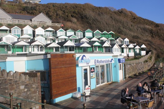
Rotherslade
Rotherslade
There is a small cove before the main sweep of Langland Bay. This is Rotherhide. Beteen the two bays is Storrs Rock which the French Impressionist painter Alfred Sisley painted in 1897 whilst on staying at the Osborne Hotel, which overlooked both Langland Bay and Rotherslade Bay, which was also called Lady’s Cove. His stay here must have been very a bitter sweet. He had come come to marry his partner, so as to legitimize their two children, but both he and his wife were dying of cancer. He painted Storr’s Rock at many times of the day.
Storr’s Rock 2018
Storr’s Rock (2018)
Langland
Langland Bay
Langland Bay is very popular with surfers and day trippers but its unusual for modern day sea-side towns, as it has not been hollowed out by holiday lets. That’s because Langland is an expensive place to live and its tiny lanes are often filled with Mercedes and BMWs. Wales’s first millionaires, the Merthyr iron-masters the Crawshays, set the tone in the mid-19th century when they built their massive summer residence here. It was originally known as Llan-y-Llan and looks as if it was ripped intact from the Scottish Highlands. It was later part of the Langland Bay Hotel but is now called Langland Bay Manor and been converted into swanky apartments that wont leave much change from £300K.
Old Postcard of LanglandLangland Bay 2018
The clean lines of green and white beach huts have become another status symbol. These striking green and white huts were built in Victorian and Edwardian times. They used to be dolled out to families on a lottery basis, at the very reasonable price of £236 for a three months lease. More recently, however, a cash strapped council decided it would raise money by selling some of the refurnished hut’s leases at a whooping £10,000. You would get to use of your hut for ten years and although the huts can be used every days of the year, you cannot sleep in them in overnight. I don’t know if anyone checks this! None of the huts were in use when I walked past but it was a chilly midweek day in March.
Langland from Snaple Point
Gower Coastal Path from Langland to Caswell
I continued my walk around the bay and again instead of following the official Coastal Path, I climbed up Newton Cliff which is alongside Langland Golf Club to look across Langland Bay.
Langland Bay from Newton Cliffs at Sunset
After the climb up Newton Cliff I was starting to get tired. This is when I made a stupid mistake. I left the beaten track. In stead of following the footpath down the hill to rejoin the official coastal path, with its easy tarmacked surface, I decided to try and follow what I thought was a path along the top of cliff along the edge of the golf course. The sun had gone in and it started to spot with rain. This was a disaster, I ended up struggling down paths covered in brambles sleeping-beauty-style, only to eventually admit defeat and retrace my steps. It was a long detour. I ended up asking directions from some rather bemused looking golfers. I could tell one of them wanted to tell me off for being on the golf course but I was apologising so much, he just said “you shouldn’t really be here” and then directed me back to the official path.
By the time I reached Caswell Bay, I was very tired indeed. I had eaten the single banana I’d brought to eat long ago so I queued for minutes in the very crowded “Surfside Cafe” and bought a chocolate ice-cream which revived my spirits considerably. I then waited at the bus stop for the hourly bus back to Swansea.
What I learnt
It hard to write notes on a bus.
Take sandwiches.
Stay on the beaten track – if there’s no post it’s not a path.
Look at the map – put it in your pocket, don’t leave it in your rucksack.
Leave longer than you think
Leave the book on Gower History at home. It’s heavy.
Don’t believe the weather forecast. It can go from warm sun to wind and rain.
Most importantly, check your camera lens for smudges. Most of the photos I took today were no good (see below).
Langland Bay with smudge on the left side of the lens!
What I got right
Coat with hood
Walking boots
Bananas are great
Water bottle – its heavy to start with but you end up drinking most of it.
Next post – Will lots of chocolate biscuits see me through to see the stunning views from Pennard Cliffs?
P.S. Here’s some drone footage of the coast and Langland Bay (BTW The sea isn’t usually this colour)
I love looking at maps. I have been gazing at the map of coastal path around Gower for days now. The Peninsula juts out westwards into the Bristol Chanel. Its about 17 miles in length and 8 miles width at its widest point. I am planning to walk around its coastline, approximately 38 miles in length, maybe a bit less.
I am, however, going to start with a map of Swansea Bay. People who have never been to Swansea make jokes about the place as if its somewhere to avoid. Quite the opposite. The hilly city sits alongside the sparkling sea and beautiful sandy five-mile beach.
Swansea Bay
I have decided to illustrate this series of post with my paintings and with (mostly) my own photographs. The paintings have been completed in recent years, some as a result of this trek, other are older. The photos are mostly from 2018 but a few are from my 2016 attempt to walk the Gower coast. I started my first attempt at Mumbles in 2016.
The pretty Victorian village of Mumbles sits at the far end of the western arm of Swansea Bay. This is where my journey around the Gower coast begins.
Round Mumbles Bend
Mumbles was originally a fishing village. It did not catch fish but rather, oysters. It was, for a time, a thriving industry. Part of Mumbles is known as Oystermouth and many people often use the two names interchangeably to mean the same place.
The Strange Afternoon (Mumbles & Oystermouth Castle)
Many people often associate South Wales with coal mining, and coal was certainly vital in locating the copper industry in nearby Swansea. It was the need for limestone, however, that changed Mumbles’ fortunes. Limestone was used as a fertilizer, in steel making, pharmaceuticals, and also as a construction aggregate (in other words, gravel).
Tide’s In (Mumbles)
Mumbles was made of limestone and that fact brought the modern world to the front door of this tiny fishing village in 1804 when the Oystermouth railway line was built in order to transport limestone from the quarries of Mumbles to Swansea Docks. This track was the world first passenger line, the Swansea and Mumbles Railway, carrying at first horse-drawn carriages, and later steam locomotives.
Mumbles Pier from Knab Rock
The trains also brought many day trippers for a time. The railway is now long gone, closed in 1960, but there remains a sturdy promenade that runs along the sea front where the trains used to run. Locals and visitors alike still love to walk its length and admire the spectacular view across the sweep of Swansea Bay.
Afternoon Stroll in Mumbles
The promenade runs up to Verdis, a popular ice-cream parlour and thence to the Mumbles Pier. The Victorian pier was built in the last years of the 19th century and was the last stop for the Railway. Here tourists could catch a paddle steamers for a tour along the River Severn and Bristol Channel. The Pier hosts a great cafe (with self-playing piano), an amusement arcade and tiny art gallery.
Mumbles Pier
On the other side of Mumbles Head is Bracelet Bay. Mumbles Head comprises two tidal islands. At low tide those with stout boots can walk out to the islands and look at the much-photographed lighthouse.
Towards Mumbles Lighthouse
The octagonal lighthouse lighthouse was built in 1794 by Swansea architect William Jernegan, who also designed Singleton Abbey which later became part of Swansea University. This was the second attempt to built a lighthouse here. The first one started a few years earlier, designed by someone else, collapsed before it was even finished!
This is where the real Gower coast walk begins! In my next post I puzzle over myriad bus timetables and eventually feel brave enough to leave the car behind! In the meantime here’s a cool video of a drone flying around Mumbles Head. https://youtu.be/MvGQhPzQlKo
I am delighted to have been featured in April’s edition of Welsh Coastal Magazine as part of their ongoing series “Inspirations” on contemporary artists in Wales. I have included some images but you can read the online version here.
If you would like to buy prints from artmajeur.com click here.
One result of developing PTSD over 5 years ago is that for a long time I had limited energy. I honestly cannot tell whether my energy levels have returned to “normal” levels yet, or ever will. I find that it takes me a couple of days to recover from social events (and no, it’s not a hang-over as I don’t drink alcohol) or from traveling/visiting family or another town. Maybe, everyone my age is like, I don’t know.
I used to have ambitions or even a sort of “bucket list” of things I wanted to get round to doing, some time. I don’t much care for the term “bucket list”. If you haven’t heard about the term “bucket list”, it is a list of all the goals you want to achieve, dreams you want to fulfill and life experiences you desire to experience before you die. Here was mine.
Learn to surf
Learn to Meditate
Walk the coastline of Gower
Run a marathon
Walk the pilgrimage route to Santiago del Compostela
Visit Japan
I did learn to surf and I was very keen for a while, but I was never terribly good at it. I also once went on a 10-day meditation course. There was no talking for 10 days. Strangely, that was the easy part. I was running 20-25 miles on a weekly basis when my life took a swift left turn and everything ground to a halt in 2012. I am still active but I don’t run very far at all these days. I know I won’t be able to run a marathon unless I gave up everything else and just trained, ate and slept. There would be no energy left over for painting and making a living, so that’s out of the window. I cant afford to travel, not at the moment so it’s going to have to be number 3.Walk the coastline of Gower.
I have a curiosity about exploring the whole coastline of Gower. I know and love certain parts of it very well, such as Three Cliffs Bay. As a painter of the Gower peninsula there are parts that I have visited and painted many times. However, there are also parts I have not visited for years, and a few places I have never visited. I did plan and start to walk the Gower coast in 2016, but it all came to a halt as I tried to cope with the repercussions of being made redundant from my teaching post where I had worked since 1999.
So start again. Here are my rules
Travel in a clockwise direction around the Gower coast
Travel by public transport and by foot.
Walk on sunny days.
Erm, that’s it.
I will document the walk with photos, sketches, and paintings. However, I am nervous about this. The big challenge for me will be in terms of my energy levels. The whole coastline is something like 38 miles long and I know I will have to divide that up into many short walks that will be very tiring for me. I will probably need a week to recover in between walks. I am nervous that I won’t have the determination to finish this, or something will happen to put me off, such as in 2016 when I got part way through in 2016 and gave up. I hate not finishing things.
Coast Watch Station, Rhosilli
It will also be challenging for me mentally. When I was younger, I did many brave things on my own. I traveled around the UK and spoke at Academic conferences, I even traveled to Texas very soon after I passed my driving test and drove a hire car. The PTSD has had the result of reducing my life and what I do, either because I get tired or because I am fearful. PTSD means that my brain goes into anxiety mode very easily. My head will worry about the coming back before I have even left the house. I will convince myself that none of the buses will arrive and I will be stranded in the wilds of the Gower and have to sleep under a bush. Yes, it all sounds stupid when I type it, but that’s the sort of thing that keeps me awake at 3am in the morning.
So I will have to prepare well, take a load of bus timetables and set off early and challenge the fear. A few weeks ago I panicked and jumped into the sea, thinking I was about to get washed off some rocks. Bizarrely, the evidence has given me confidence. The boots and I survived. It was uncomfortable but the boots dried out on my radiator. So I will make a start this week, even if it takes months to complete the challenge.
I am very lucky to live close to the sea. I can never get over my excitement at seeing the sea, even when I live so close to it. I would say that all of the Welsh coast is pretty special. The coast along Pembrokeshire, Ceredigion and the Llyn Peninsula are spectacular however, the Gower peninsula is the coast I visit most often as it’s the easiest to get to for to get to and its paintings of the Gower peninsula that work on most often.
Gower has some incredible coastlines and fabulous beaches. I have always wanted to walk its length but never got my act together to do it. I made plans to do so in 2016 but being made redundant from my teaching job in that year, sort of threw everything out of kilter for me.
The best beaches always involve a bit of a hike but its always worth it. From an artist’s point of view its always different. Whether its high tide, low tide, summer, spring or a blustery winter’s day. What’s the main difference between the seasons? The light. Whether the sun is high or low in the sky, the angle of the rays, the quality of the light. Is it sharp or is it hazy?
Floating Clouds over Three Cliffs
I have painted Three Cliffs Bay quite a few times. I am find it interesting to reflect on the different ways I have approached what is in some ways the same subject matter. In winter the sea is a grayed jade the wet sands are pinkish, the dry sand different shades of yellow. The colour of foliage is very muted; the grass on the clifftops is more yellow than green and the bracken is brown. The cliffs are warm grey in direct sunlight, a cooler grey in shadow.
Even on brighter days when the sea has more violet the colours of the cliff tops is more yellow ochre than orange.
Coloured Sands at Three Cliffs Bay
Three Cliffs Bay at High TideWhat surprised me when I compare these winter paintings with some that I had done in the summer is that the wet and dry sand is the same ruby/pink/yellow tones, although it seems obvious that it would be now I think about it. What is different, is the sky and the colour of the grass and bracken on the cliffs. The sky is a lighter turquoise and the sea is has more jade and turquoise. The clouds reflections in the surf is still violet. The grass is wonderfully verdant, a sharp green.
This is the oldest painting and it was done in high summer when the grass is a deeper green.
Of course, looking through these paintings, I immediately wish I had done some autumn paintings when the bracken is a rusty red. I have painted Rhossili Bay in autumn but not Three Cliff. I can’t think why not. Of course, last autumn I was focusing on my “Hollowed Community Project” and painting houses. I hope that I will be able to come back and paint Three Cliffs again this autumn.
The sun is out. So I am out too with my camera. Looking for inspiration for some Gower landscape paintings. We drove down to Rhossili at low tide to look at the rocks. My husband is from Northern Ireland and he was feeling homesick for some monumental rocks like those at Giants’ Causeway. Now, Gower doesn’t have pillars of amazing basalt rock but we do have some pretty grand tors.
The walk from the National Trust car park at Rhossili was certainly bracing. The wind was super cold and strong enough to make me nervous about approaching the cliff edge to take photos. People have fallen to their deaths here. The sheep are all pretty blase about it, though.
Blase Sheep in the wind
Behind the bay rises Rhossili Down to a height of 600 feet. It is the remains of an old beach level much eroded later on by the ice sheets of the last but one ice age. The bench of land below, with the Old Rectory in its middle, was caused by earth slumping down from above during a cold phase. Although, it seems like a wild and out of the way place, people have been here for a very, very long time. A Neolithic hand axe – the oldest human artefact found in Wales – was found here and is now on display in The National Museum in Cardiff.
Worm’s Head
We walked into the wind and past Worms’ Head with its exposed causeway and found a flock of sheep eating turnips scattered amongst the straw-stubbled ground. We walked along cliff tops, and looked over a long dry stone wall inland to the medieval strip farming that still continues in the fields there. This is one of only a few Medieval “Vile” Field systems left in Britain.
Sheep on a Medieval Strip Field
The path then splits. You can continue along to top of the cliffs to Mewslade or take a path to the right which dips down to the top of Fall Bay. There is a small collection of wooden boats way above the beach, some are attached to metal rings embedded into the rock. Its a lot easier to make your way down to the beach through this path than it is via a gap in the cliffs at the east end of the beach.
The high parts of Gower are made of the oldest rocks. The downs that loom over Rhossili and Cefn Bryn are made from Old Red Sandstone.The rest of Gower is made from Carboniferous Limestone. The coastline cuts across a bed of folded of Limestone at an angle of 45 degrees towards the sea, to expose curious diagonal layers of rock.
Layers of Rock at Fall Bay
View Towards Mewslade Bay
So here my afternoon takes a slightly wetter turn. I had climbed onto rocks that lay between Fall Bay and Mewslade Bay further along the coast. The sea was crashing around me. I felt quite safe. The rocks were not slippy. I thought the tide was still going out.
Then my husband shouted at me “The Tide’s Coming in” and I looked at my watch. It was exactly 3 o’clock. Low Tide. For some reason, I then decided that the crashing waves were coming a lot closer. I hesitated, the patch of beach I had jumped from onto the rock was submerged in incoming water. I waited. The water just got deeper.
Then, my stupid PTSD head kicked in. It goes for the worst scenario. What if it never retreated? What if was going to get washed away? I was going to get washed away! I was certain. So, I panicked and jumped into the water. It came up to my calves. It was really cold. The bottom half of my jeans were very wet and my walking boots full of water. I sloshed through the sea water and onto dry land. Emergency over, I tried to cover my sense of foolishness by blaming my husband for “frightening me”.
I didn’t drown or even catch cold for having to walk back to the car with wet boots and drive home again. I had a hot bath as soon as I got home but there’s always part of me that believes that you have to suffer (or at least go to great lengths) in the process of creating your art so I find mild exhaustion and hardship rather satisfying. As if deep down I think it will somehow make the paintings better!
I am delighted to say I have been asked by Welsh Coastal Life Magazine to submit some coastal paintings, mostly of the Gower peninsula, to be featured in their magazine. I sent the following images to give a geographical running order, if you like, from Swansea Bay via Mumbles to Gower, to Tenby and up to Morfa Nefyn on the Llyn Peninsula in North Wales.
I always struggle in the winter. It creeps up on me. I start to feel down although nothing particularly bad has happened. I feel myself start sliding. Then the thing takes on an almost physical shape. I can feel the edges of the thing starting to weigh heavily on me. Then, in the back of my mind, a thought dimly appears; “You Need Light”.
I suffer from Seasonal Affective Disorder (SAD) or winter depression, although I can get it during really wet summers when the days are overcast, day after day. This year has been particularly tough. I am often thinking thoughts like “Why is it so dark?”, “Oh no, is it night already?” and “How long until the sun comes up?” It seems to get worse with each passing year. Maybe it just because this winter has been particularly cold?
Fortunately, I have a couple of SAD lamps and one of those alarm clocks that will mimic a sunrise. I just have to remember to switch them on and sit next to them. I don’t always do so. So, here I am now with a lamp on and I can feel it cheering me up getting the hypothalamus in my brain to work properly. Earlier, when there was some gloomy daylight I painted a couple of summer beach scenes. I felt very happy painting the people on the beach in the blinding summer sun. I thought about the day back in the summer we visited Port Eynon, on the South Gower Coast. The sea was glassy. It was so warm that paddling was wonderful. We had chips for tea. It was lovely. It was a day when you didn’t feel the need to “do” anything. You were quite happy just sitting in the shade watching the people on the beach.
I have long suspected that my tendency towards SAD is one of the reasons why I paint so many sunny and bright scenes. I feel much better for thinking about this wonderful summer’s day and painting these two beach scenes.


 Following the coastal path around the very windy edge of the cliffs, you eventually reach around the top of Great Tor and Tor Bay below.


 Oxwich Bay is a wide expanse of water and sand. It’has a sandy beach which is about 2 1/2 miles long, flanked by sand dunes, patterned by a maze of tracks. Beyond the dunes lie lakes, woodlands, salt and freshwater marshes. Apparently, it’s rare to have so many different habitats in such a relatively small area in the UK. They are all part of the Oxwich nature reserve.


 The beach and the dunes are bisected by Nicholaston Pill, a small river that flows out from the marshland and reeds. I’d forgotten that there’s a little wooden bridge over the river, tucked away in the dunes.


 There was a middle-aged couple sitting on the sand dunes with their dog. I stopped and we had a long chat, in which we discussed in quick succession; the weather, buses, Cardiff, Swansea’s one-way traffic system, the council, the Slip Bridge and buses again.


 There are several caravan parks within walking distance too. When we first came to Gower we used to come here and I once attempted to surf here. It didn’t go well as I paddled too far out and got scared.


 Once upon a time, all the houses in Oxwich would have been thatched. Now few are except the cottage that has gained fame for being the place the Methodist Minister, John Wesley once stayed in 1764. It was known as the “Nook”. The well-traveled Wesley was impressed by the people of Oxwich as he noted in his diary that “all the people talk English, and are in general, the most plain, loving people in Wales’. There is no pub in Oxwich and it has been suggested that the influence of John Wesley may have had a bearing here!


")


 Gower
Gower 


