Last summer I started my series of “Urban Minimal” paintings of the streets of Brynmill, Swansea. These paintings were my “Hollowed Community” project which were exhibited in the that year’s Madeinroath Festival. That’s not a typo, by the way. The festival organisers stipulate that you type it as one word Madeinroath, rather than three “made in roath”. Roath is a suburb of Cardiff, by the way. They also stipulate that the “in” in “Madeinroath”has to be in red too. It’s driving my spell checker crazy!
My “rules” for composition and painting this project were:-
No cars
2. No People
3. Bright light. There must be shadows – at diagonals if possible.
4. Simplified forms – there must be little detail in the final painting. I want to explore the interplay of the geometry of shadows and man-made structures – the tension between the 3D buildings and the 2D shadows. Simplified blocks of colour.
These rules worked well in an urban setting, especially with the sea light we have in Swansea.
Since then, I have been caught up in my Gower Coastal Walk.
By my calculations, I have three, maybe four more Gower walks to do in order to complete the length of coastline but other commitments are keeping me from finishing. Firstly, I have a pile of exam scripts to mark. I am rusty and I mark slowly these days. Secondly, a summer virus has made me feel under the weather.
I haven’t consciously applied the urban minimal rules in a non-urban setting. What’s the problem? The applying Rule #1. “no cars” and #2 “no people” rules is easy enough. As is #3 “Bright light”. Then there comes the difficulty. The second part of Rule #3 “There must be shadows – at diagonals if possible.” Walking late morning, mid-day day means that there are few long shadows and they are difficult to find on beaches too. Although, there have been a few.
Langland (SOLD)
High Tide at Three Cliffs Bay (SOLD)
Finally, Rule #4 “Simplified forms – there must be little detail in the final painting. I want to explore the interplay of the geometry of shadows and man-made structures – the tension between the 3D buildings and the 2D shadows. Simplified blocks of colour.” I never really followed this rule to the letter as I thought details, such as window sills, and reflected light on glass, breathed life in pictures. It was knowing where to add detail and where to simplify that was important.
Coloured Sands at Three Cliffs Bay (SOLD)
Here, I have just been very cautious about going “too far” with this in a rural setting. But I have been edging that way, such as with my treatment of sand. Other aspects of my composition such as clouds and vegetation have not really been “minimal”, not in a conscious way anyway.
I think I need to challenge myself and make myself think about how I am tackling these subjects. I think my recent paintings of rural buildings (that’s cottages to you) has been much more successful.
Port Eynon Shadow (SOLD Oil on Linen Canvas, 46x38cm, unframed)
You may well say are just rural buildings instead of urban buildings. Yes, but they are stepping stones. I am still thinking about how I apply these rules when there isn’t a building in the picture!
Afternoon in Port Eynon (Oil on linen canvas 33x41cm unframed) (SOLD)
Do believe the hype. In 2014, Rhossili Bay was voted the UK’s number one beach, by TripAdvisor users, it also ranked third best in Europe, and 9th best in the world. They are not wrong. The bay is spectacular. the wide flat beach curves along for 3 miles (5 km) and is backed with sand dunes along the northern half. It is quite vast.
Rhossili Bay
How I have missed Gower and walking over the past weeks! I have been stuck in doors invigilating exams for one of the local universities, longing for the sea breezes and the sort-of-quiet of outside. The Gower is actually quite noisy with the sound of surf, sheep and birdsong, but they are all nice sounds.
The fresh air is a tonic. There is plenty of it at Rhossili. One thing you notice on the long narrow road to the tiny village is that there are only a few wind-blasted trees, permanently bent westwards. At Rhossili, itself there are none. It is an isolated place on the far tip of the Gower peninsula. It has two tidal islands at either end of the bay, Worms Head to the south and Burry Holms to the north.
Rhossili Sunset
In the days before cars and buses, it must have felt a lot like the edge of the known world here. Celtic monks, presumably drawn by its isolation and wilderness, came here in the 6th century. They founded a church here, dedicated to St. Sulien or St. Sili, that was founded in the 6th Century. The name St. Sili together with the Welsh word for moorland, ‘Rhos’, gives Rhossili its name. The first church, along with a tiny village, was tucked away at the foot of Rhossili Downs, on the apron of flat land ground, north of the present village, known as the Warren. The present-day old rectory is located here. Evidence for this first community was revealed at the end of 1979 when a severe storm exposed some of the old buildings on Rhossili Warren.
Rhossili Shadow (SOLD)
The Normans conquered Rhossili in the 12th century, but how did the village of Rhossili come to move? It’s a familiar sounding story involving storms and sand (remember the story about Pennard Castle and the angry fairies?) a massive storm in the 13th century sent mountains of sand ashore at Rhossili too, engulfing both village and church. As a result of the this environmental calamity, it was decided to rebuilt the village and build a new church, dedicated to the Virgin Mary, on the high clifftop 200 ft (60m) above, away from the vulnerable low lying sand and sea. Hence the wind!
Rhossili, Gower
There are two paths across to Llangennith, one high and one low. Today I decided that I would walk both in a loop. Starting with the high and returning along the lower one to Rhossili.
Map of Rhossili and Rhossili Downs
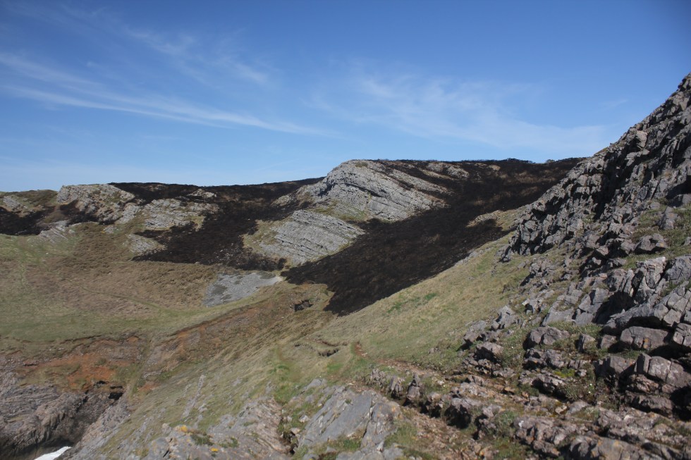
The coastal path starts just to the the right of the National Trust Car park and the bus stop. There is a choice of paths. There is the one that climbs high along the top of the Rhossili downs and the coastal path along the flat land at the foot of the downs, the Warren.
I have decided to do both by walking in a loop across the top and then along the bottom back to Rhossili. So instead of going through the gate, I head along the path on the right. Up a long steep path.
The climb and views below are breath-taking.
Worms Head to the south
Worms Head
It’s a long climb before the terrain flattens out. The wind up here is very powerful, indeed. Its blowing so hard that it makes my ears hurt. I pull up the hood of my coat to try and protect my ears.
View to the north, Burry Holmes in the distance
In the past I have seen hang-gliders take off from here and fly over the bay. There’s no one here today. I think its probably too windy. I am scared of heights so I find the thought of hang gliding terrifying – so this youtube clip is more than mildly distressing for me but it gives you a good idea of the wonderful views here.
The path is bare, and the surrounding land is heath land, covered in wash-out brownish heather. Later in the early autumn as the heather blooms, the downs become a delightful riot of pinks and purples. I must come again in September.
Path Across the Top of the Downs
I finally reach the Beacon. The trig point (its proper name is triangulation station or triangulation pillar) is part of the massive network of points built by the Ordnance Survey (OS) team as they mapped the country in the 1930s. At the towering height of 193 metres (632ft.) above sea level, the top of Rhossili Downs, the Beacon, is the highest point in Gower allowing unparalleled 360° views of the peninsula.
The Trig point on the Beacon
I usually like to walk to the edge of the downs to look down at the Old Rectory below on the Warren but it’s too windy today. I will look at it more closely on the return journey later.
The path continues northwards and dips below the headland so I can take my hood down for a few minutes, but not for long as I reach half way along the down and come across a curious relic from the Second World War; the remains of a radar station. I wonder what it was like to be stationed in this beautiful and remote location listening out for approaching German Bombers headed for Swansea.
The path continues on to another peak and a good view of Burry Holmes, the tidal island, and the caravan park at Hillend below.
Then there is a steep descent down to path that passes behind the static caravans. I did not realise that there were so many here and they seem to reach a long way towards Rhossili.
Eventually I leave the mass of caravan behind and follow the path behind an old stone wall. I spy some people walking closer to the edge of the beach.
Not the path I followed
I realise belatedly that I have probably missed the official coastal path and I am following another higher path. I cant see how to make my way down to that path so I carry on. My path takes me closer to the old rectory, anyway but it a bit further.
I am feeling tired now. I stop and eat some biscuits, enjoying the sunshine and the sound of the sheep and lambs happily bleating away. The Gower sheep here are tough mountain sheep, their long tails left are undocked (unlike lowland sheep) and they are have patchy tanny brown markings.
I can see off in the distance, the old rectory, which has been called the most photographed house in Wales.
The Old Rectory is the only building on the bay so its not surprising that it acts as a focus point for photographs. The vicar of this parish had to look after two churches, St Mary’s at Rhossili and St Cenydd’s at Llangennith. So some bright spark decided that the rectory should be built exactly halfway between the two churches, in neither village. I am not sure that any of the vicar’s wives appreciated the isolation. I suspect the vicars who lived here weren’t very happy about constant journeying between villages, as at least one, the Reverend John Ponsonby, is said to haunt Rhossili beach. He travelled between the villages across on the beach on horseback and some believe he can still be seen riding the route today.
Old Rectory
The Rectory, itself is also said to be haunted by another vicar and his wife, who some claim to have seen and heard walking down the stairs. It’s not surprising that it haunted as it believed to be built on top of a graveyard (possibly dating back to 6th century?) and on stormy nights a frightening spectre is said to emerge from the foaming waves to stare at the outside of the building, as if angered that it has been built there.
Taking the Long View
Apparently, Dylan Thomas once thought about buying the old rectory, but he decided against it as there was no pub in either villages, there are now, though.
The climb up back to Rhossili is quite steep and although tired, but I am happily distracted by the fantastic view of Worms Head and the evening light on the whitewashed houses of Rhossili that look so small from a distance.
Worms Head, Rhossili
Back in the village we are greeted by some errant sheep, jogging through the streets. Their farmer (out of shot) is rounding them up on a quadbike and a collie.
I will leave you with a drone’s eye view of Rhossili, Worms Head and the Downs. It’s well worth watching.
You can buy original paintings from the Gower Walk project by clicking on the link.
Next week I face the challenge of sea mist and climbing down a steep slope to visit Gower’s incredible swimable (I’m not sure that’s actually a word) tidal rock pool.
I can hardly believe it myself! On Tuesday I sold my 600th painting via the online gallery www.artfinder.com. My sales total had been stuck on 599 what seemed like an unbelievably long time – it was a week in fact. I have actually sold more than that either directly or through other online galleries. All of those paintings were unique too. I have never gone in for mass producing generic scenes. I believe that novelty keeps my work “fresh”.
My work may explore certain themes such as the Brecon Beacons, Gower Woodlands, Swansea people, the Gower coast, but each painting is an individual. Each painting is of a real specific place or of real people. Perhaps that shows a failure of imagination on my part, I don’t know.
Although I may have had periods when I have felt a bit “flat”, such as after an exhibition, but so far I never actually run out of inspiration. This is partly due to the world around me constantly inspires me but also, more importantly, because of the unfailing encouragement, inspiration and support provided by my artist husband, James Henry Johnston (known to his friends as Seamas – pronounced “Shay-mas”).
Seamas
Seamas founded our Art business in the midst of one of the most difficult times of my life. I had developed PTSD after a car accident and this contributed to a breakdown. Painting was an essential part of my recovery (and still is). Not only did he give me crucial emotional support through an incredibly difficult time, (all whilst sitting his Psychology finals) he set up a website and put some of my paintings on an online gallery called Artfinder. To our delight I started selling. Like many artists, I find the marketing side of the business challenging at times. I was terrified that people would be rude about my art and that would then affect my fragile confidence. Happily that has rarely happened.
So in those early days Seamas acted as “shield” and would write all those upbeat posts on Facebook about sales and upcoming exhibitions. He would also work on direct sales, face-to-face and online, negotiating terms with collectors. I have only really come to appreciate the sheer amount of time and effort he has put into promoting my work since I started working as a full-time artist and had to tackle platforms like pinterest and instagram. That term “full-time artist” is a misnomer as it might give you the impression I spend all say in the studio. I spend at least half my time working on social media and marketing.
Artfinder has been a massive part in being able to make that leap and become a full-time artist. Being self-employed is full of ups and downs, it’s very much “feast or famine” so to look back and see 600 sales over 5 years is quite amazing. Long may it continue. I was going to end this by quoting Samuel Butler, Victorian novelist and satirist who said; “Any fool can paint a picture but it takes a wise man to be able to sell it”, but I want to rephrase that with “Any fool can paint a picture but it take a genius to sell it.”
[maxbutton id=”4″ ]
Tenby Tide Large professional quality signed and mounted print £45
[wpecpp name=”Tenby Tide Large Print” price=”45″ align=”left”]
I have been asked to be a curator for Artfinder.com. This means I will put together an art collection for the online gallery http://www.artfinder.com. I am very excited and honoured by this chance. I have been represented by Artfinder since 2013 and I have sold 599 works through them. The site has grown and grown over the years and now represents over 10,000 artists.
It’s not the biggest site out there but for several years its been the best one for independent artists. I’ll explain why.
Each artist is given a lot of control over their own page or “store front”. You can directly upload photos of your paintings to the site without waiting for an administrator to approve it. You can also directly contact collectors through their messaging system, rather than through the administrator. This makes customer care a whole lot easier.
There are many very talented artists on the site but the increase in the sheer number of artists has made it more and more difficult to be “seen”. So being a curator for the day is my chance to bring attention to the many excellent and talented artists on the site.
As a teenager I used to fantasizing about having the chance to do a supermarket sweep. I used to think about where I would direct my trolley and what to sweep into the trolley in less than three minutes. Funny, how that has no appeal to me these days although, I do like to get in and out of the supermarket in a short amount of time as possible! Twenty minutes, in and out and I am happy.
This is going to take a bit longer than that!
Andrew Reid Wildman
So I have my chance to “sweep” about 150 artworks into my basket or collection. I am very excited by this. Over the years I have book marked and pinned artworks that have caught my eye and here’s my chance to show them off to the world. I try not to think too much about it. There are some artists who spring to mind immediately like Jane Kell and Andrew Reid Wildman, whom I know I want to have in the collection and others I have to look in my bookmarked collection to remind myself of their names, and a few who present themselves to me as I look through the new art on the site.
Snehal Page
James Earley
I have largely gone with works that highlight colour and light such as Snehal Page’s vivid oil portraits and Sri Rao’s colorful landscapes.
There many artists’ who skill with the paint brush has me in awe especially people like James Earley and Abi Whitlock.
One hundred and fifty painting may seem like a lot but it isn’t. I want to include as many artists as I can with out the collection becoming too “bity”. So some artists get as many as 4 paintings but other only one. I am hoping that the choices I have made will tempt collectors to click on their names and take note and “follow” them or even better buy their work/s. I believe that art is about a conversation between the artists and the viewer.
John Kerr
I say conversation, but I believe that good art provokes an emotional reaction in the viewer; whether it is joy at the remembrance of a summer’s day at the seaside, or empathy with the humanity in another’s face or posture.
James Henry Johnston
As viewers we invest a lot of energy in choosing our favourites, we follow their progress and want them to do well. I am only the 5th artist (I think) who has been asked to put together a collection but I am hoping this a successful collection and other artists are asked to do the same thing.
If you wish to view the whole collection, you can see it here
Who hasn’t attempted to create a photographic panorama? Back in the 1990s when cameras contained stuff called film, I remember often standing looking at some amazing view, and then slowly pivoting from left to right (and then right to left in case I’d missed something) taking a series of overlapping photographs. The hope was that I would recreate a some stunning vista; such as the Grand Canyon, the London skyline, or even the lovely Alhambra. After a long wait, the photos would come back from the developers and I’d dutifully stick them together. The results were usually underwhelming. Rather wonky. If, you tried really hard you could sum up the awe of the view that had inspired you, sort of. I don’t think the sticky tape added to the overall impact, either. I give you in evidence the example below which I found lurking in one of our crowded cupboards:-
Oh dear. Obviously I wasn’t the only one who was disappointed by their efforts to capture their holiday vistas in this way as companies like Kodac developed special disposable panoramic cameras so you did not have to tape your photos together. I will never know if they were any good because I never had one.
So, forgive me if I have pretty much spurned panoramic compositions until now. In fact, I have had a long phase where I chose portrait orientation for my landscape compositions whether rural or urban. I really liked the sense of piles of houses on houses, or field upon fields. It works well in hilly Swansea and mountainous Wales.
It’s not like I never tried narrow canvases. I did use a couple of small narrow canvases to paint Mumbles, the village at the end of Swansea Bay. The paintings turned out well but I didn’t really enjoy the experience. I didn’t really ask myself why not until now. I think it was partly because I was in a portrait orientation “groove” and partly it was because the canvases were too small, they felt mean and didn’t really convey the essence of Mumbles.
It was a client who got me using panoramic canvases again. He wanted a landscape painting of May Hill in Gloucestershire. We originally discussed using a 80x60cm canvas but then he decided he wanted a narrower canvas; 80×40 cm. This was inspired. This immediately improved the composition because instead of the landscape getting lost against too much sky, it actually balanced the composition. It gave the land in the painting more immediacy and intimacy.
Full size source photo
May Hill 80x40cm
Now, you might say that this is not particularly “panoramic” but it got me thinking. Narrower canvases would suit coastal paintings because too much sky often has the effect of “shrinking” the land/coast in a composition. I’ll give you a photographic example:-
So using a long narrow canvas works really well with compositions for certain scenes, such as the one of Worms Head I have shown above.
All good so far, but what about the frustrations? There are the logistical issues surrounding using longer canvases. It may sound daft, but they are long. I find it hard to store them in my small attic studio. They poke out. When it comes to painting, I found that painting of the far left or right of the canvas quite a challenge. You see, I don’t usually bother with using the clamp at the top of my easel when I am painting as I often like to rotate my paintings and paint a canvas “upside down” or even “sideways up/down”. Oh, no. I have to clamp my painting in place or else it flips away from me when I press on it to paint any part either side of the central part. Rotating the canvas becomes a hassle too. My arms are not quite long enough to adjust the clamp without standing up.
Rhossili Sunset (SOLD)
This may all sound very lazy but once I start painting I get into a groove or “flow” and can barely be bothered to move from my central position other than put my brush on my palette and then onto the canvas. This is why I usually end up drinking lukewarm tea even though it’s in a thermos-style travel mug. It’s very rare that I get up to change the station on my radio. This is how I end up listen to sports programs (even football matches) although I am definitely not a sports fan.
The satisfaction of a well-balanced composition and having less sky to paint is worth it.
Worms Head, Rhossili (80x40cm) (SOLD)
Then comes the issue of how to show it on my website and social media. There is no problem uploading the image to artfinder.com – it comes up as a complete image on my page.
However, when I uploaded it to my website the thumbnail cropped the image (see below left).
So, I have to go on canva.com and create a new version of the image. I paste the image on a white background so the image will viewed whole. Thus:-
Finally, Instagram. I have the same issue with Instagram as I do with my own website in that it only shows part of the image so I decide to chop the picture into two halves and upload them separately. Only I do it the wrong way around at first and end up with a back to front image. I make a note (I draw a little diagram in fact) the right side has to uploaded first and the left second.
It looks better on my smart phone. But you see the problem, as new images are uploaded it is pushed along the feed and gets split up between the lines of images. I also don’t know if people looking say the left side of the painting will understand that it’s part of a pair. They’ll just think it a painting of a beach and won’t realise that there’s a long mountainous headland to go with it. *sigh*
Never mind, I think that the best way to show off the panoramic paintings is on this blog!
Here’s my most recent and ambitious long landscape painting. If you click on the title you can see a bigger version.
Where we live is very important to us. Where we grow up shapes us for the rest of our lives, for good or bad. When I have an anxiety dream its often about moving house. I put this down to the fact that during my childhood we moved many times; Hereford, Newcastle, Whitley Bay and Gloucester. I had been to 9 difference schools by the time I was 11. I carried on moving for my education, first to Cardiff, then to Peckham and Greenwich in London and finally Swansea.
The house where I spent my teenage years in Gloucester no longer exists. It was knocked down several years ago. It was built in 1976 and was gone 30 years later. I find that odd. I have been past the spot where it used to stand and I find its absence unsettling. I think that’s why I love the solid Edwardian terraces of Brynmill, these houses have been here for over a century. The grand mock Tudor houses of the Uplands, built in the inter-war years of the 20th century will last and will, hopefully, last another century.
David Fry bought a painting of mine, “Proud House”, a while back. Imagine my surprise and delight when he contact me to tell me that it had brought back many childhood memories for him and it inspired him to write a poignant poem about it. I thought I’d share it with you.
WHAT I SEE – A Proud House
Join palette with oils tincture and powder to display
The artist draws down with sight and prodigious emotion
As alchemist hails a canvas sharp lined spare skilled too
An affectionate depiction smoothed fine in occult lotion.
What do I see in authentic rendition so germane
A rare gift in practiced thought and summit won
Is this an ethos for other endeavours by artists told?
No…mesmerised true in a story book I am held by this one.
Maybe I glimpsed what was intuition a fable in the making
To bind a time and way to a journeyman’s remembered sight
But mostly I am filled with a bitter sweet regret
From childhood certainty in family life to lonely night.
A house transcends all purpose and design
And paint surpasses in hindsight the record of focussed light
Imbued with lives lived rich and sheltered in wallpaper defined
Something raised above all description a distillation bright.
School friends gone their paths fade in narrow winded days
Histories will reveal life travels worn their purpose long set
Hope boxed my laughter hard with glass at times half full
But the proud house survives still and is well met.
Proud House
I am taking a break from my Gower walk until mid-June to work as an exam invigilator for the university.
One thing I will say for Swansea Tourism is that they provide excellent free maps of the Gower. You can pick them up at “Information Points” around the city. I invariably have one folded into my pocket or in the front of my rucksack. They are small enough to be folded and stored easily like that. Not like my massive Ordnance Survey Explorer map of Gower. It’s about 20 years old so I don’t like to get it out unless I really have to. I am not very good at folded maps back into their original shape. Even the free map when is essentially a A2 sheet of paper (42 x 60 cm or 16.5 x 23.4 inches) printed on both sides causes me trouble in a good breeze.
I don’t really need my map today as the path follows the sea in a logical manner. The coast path signs appear at all junctions to make it clear which way I should be going. I do need the map to work out where something called the Knave is. The knave is a triangular slab of rock. I had come across a beautiful photograph of the Knave by Paul Edwards and was quite intrigued by it, as I had never come across it before.
The Knave – Paul Edwards 2012
I did not get to see the Knave from the same angle as Paul’s photograph on this particular walk.
The Knave from the coast path (west)
The Knave from the coast path (east)
From the coast path the Knave looks a bit like a dragon beginning to unfurl itself. I say that because there is a much larger dragon ahead, I am looking forward to seeing close up. I don’t have the time or energy to walk down to the Knave beach, today, I will leave that for another time.
The Knave
I carry on the path towards Rhossili and my attention is drawn to the houses and farms that lie away back from the cliff edge. You can see them from miles away and I wonder what they are like inside, looking out at the sea.
There is lots of wildlife to observe. I can hear a lark’s rising song and I see black crows. Dylan Thomas probably would described them as “bible- black”. I see a robin. I think on every walk I have been on I have seen robins, whether I am in woodland, by a wooded stream, on heath land or on on the clifftops, they really must be very adaptable little birds. I even see a rabbit; his white tail vanishing into the gorse. Apparently rabbits are a vanishing species in the UK, their numbers have fallen by 80-90% in the past 20 years so I am happy to see one out here today. I also see and manage to photograph a solitary tortoiseshell butterfly. Although, it is one of the most widespread butterflies in Britain, it too has suffered a decline in numbers.
Tortoiseshell Butterfly
It is lambing season and the path is littered with sparkling white-fleeced lambs, twins and singletons sunning themselves along side their mothers. Maybe it’s my imagination but many of them seems to be smiling as they relax in the sun!
The path passes a series of narrow gullies down to the sea, Foxhole and Butterslade, and then the magnificent Thurba Head, a headland with 200 foot sheer cliffs down to the sea.
Part of Thurba Head
View from Thurba towards Worms Head
View from Thurba eastwards – where I have just come from
Mewslade. Here there is a path down to the sea, there is also a long dry stone wall that trails down to the sea. It is in the process of being repaired. I stop to look at the stones and marvel at the craftspeople that know how to arrange the stones to make a sold wall, all without cement.
Round Mewslade
If you go down to Mewslade, at low tide there is a beautiful sandy beach but at high tide there no beach at all, just rocky cliffs.
Mewslade at Low Tide
Mewslade – tide’s coming in!
At low tide, you can supposedly walk from Mewslade to Fall Bay around the next headland. I think some rock climbing might be involved. When I tried it from the other direction (Fall Bay to Mewslade) I ended up with wet boots (it’s a long story.)
Waves at Fall Bay
After Mewslade I am getting excited as I can see Tear Point at the far end of Fall Bay. I have walked this part of the path quite recently and although I am getting very tired, I have a sense that I can do this. This long walk will be completed.
Tears Point off in the distance
Now onto the climax of this long walk; Worm’s Head. As historian Wynford Vaughan Thomas called it “the Land’s End of Gower”. Its still quite a way until I reach the bus stop in Rhossili but I am now powered on by the sight of the Worm (in Old English “Wurm” means dragon).
The Worm (left) and Coastwatch Station (right)
This curious dragon-like, tidal island snakes off into the sea. I have seen seals on the leeward side of the island. Between the cliffs and the Worm is the causeway, it is visible this afternoon. It is a rocky mess of rocks and rock pools, which is open for 2.5 hours either side of low tide. At low-tide, the causeway can be crossed to the island. It is usually fatal to attempt to wade or swim to from back from the Worm when the causeway is flooded or partially so. Sadly, people have died tried to do so.
It’s one of the jobs of the little Coastwatch station, perched on the headland, to stop people from risking their lives doing this. It’s a stout and sturdy single story building is made of granite. It has been sitting alone at the top of the high cliffs that look out towards Worms Head and beyond to Lundy Island and to the Celtic Sea for well over a century. It’s also looking out for fishing and leisure craft who might experience difficulties off the rocky shoreline. A team of local volunteers look after from the coastwatch station; from 10am till 4pm in the winter and 10am till 6pm in the summer. If at the end of watch the Causeway has not yet flooded and there are members of the public still out on Worm’s Head, the watch is kept open until everyone is safely back on the mainland.
Kitchen Corner is a small bay to the right of the path that leads down to the Worm’s Head causeway. The boathouse was built in the 1920s and is often used as a location for fishermen although there was no one here today.
I had looked at my watch and discovered that it had just gone 2pm. According to the notes on my post-it note there was a bus back to Swansea at 2.32 pm and then at just before to 4pm. I decided I would try and make the first bus.; It would involve a bit of a speedy march and by now I had a ranging thirst and I knew I would need to refill my lone water bottle somewhere. So I put my head down and forced my limbs to move as fast as I could along the long smooth concrete path from the Worm back up to Rhossili. A classic case of just because you can see it, doesn’t mean it close. It’s actually about a mile in distance.
Even as I am steaming along the path, I still have to pause and take a few photos of the incredible view across Rhossili Bay of Llangennith Beach. I pass people on the way, many different foreign languages floating on the breeze; German, Spanish, Chinese, Hindi. Of all the places on the Gower peninsula, this is the one that draws vistiors from all over the world, everyday, even on a day with bad weather. I love the international aspect of the place. It make me feel like I am citizen of the world.
I finally make it up the long path into Rhossili village. I also had time to stop off at the National Trust Conveniences to refill my water bottle. I am relieved to see that there is someone else waiting for the bus too. Always a good sign. An empty bus stop always has me wondering if I have just missed the bus.
It took me four hours to walk from Port Eynon to Rhossili. Was it 6 or 8 miles? It was probably 6 but it felt like 8, will all those ups and downs. I started the walk thinking about a slight twinge in my right knee – latter on I had forgotten that twinge in favour of my aching upper thighs (from going up and down hills), then it was aching calfs and finally whilst sitting on the long bus journey back to Swansea it is my feet that are throbbing.
So what did I learn today?
1. Remember suntan lotion. I should have put on suntan lotion. My right arm is burnt My left arm is fine. I now have a small tube at the bottom of my rucksack.
2 Water. Bring more water. Two bottles. Bringing enough water is more important than bananas, plaster, handbags and so on. I will bring two bottles on my next walk.
3. Finally, “Just because I can see it, doesn’t mean it’s close”. It’s now my walking mantra. However, it can be encouraging to see the end of your journey even if you are not there yet. This can be metaphorical as well are real – I can see the end of this journey now. I am over half way. I have walked over 18 miles out of the 32 or so I will need to do to complete this coast walk. I am buoyed by this feeling.
I have to pause in my journey around the Gower Peninsula because I have exam invigilation work for the next three weeks.
This is the most challenging leg of my journey around the Gower coast, thus far. It is the longest walk I have done so far at 6 and a half miles. For some reason, I keep thinking its much further than that. I had convinced myself that it was 8 miles. It felt like that.
I have been obsessing over the bus timetables and the information I have garnered from Traveline.com which makes sense of the bus connections for me. I have written all the available buses in my note book which I carry in my rucksack as well as on a cheery yellow post-it note which I have in my coat pocket. I have tried very hard not to think of all the things that could go wrong but at 4 am I have persistent visions of twisted ankles and buses not turning up. I pack two plasters although I suspect they won’t be massively useful if I do twist my ankle. Yet, it seems that I have done all my worrying in advance for once I set off everything pretty much goes without a hitch.
It is a warm day. I am wearing my light padded jacket for the first time this year. My rucksack, which is actually my husbands old laptop rucksack, contains the following:- Water bottle; food – sandwiches, banana, biscuits; bus timetables for all Gower buses; tide timetable; two plasters; spare socks; camera; handbag. Somehow I haven’t organised myself enough to leave my stupid handbag behind. I know it has many useful things in it like a tape measure, make-up mirror, phone, fold away shopping bags, but I suspect it adds a fair bit of weight.
I dont have to wait long for the number 118 bus to arrive on Gower Road in Swansea. The bus driver blinks at me slowly when I ask “Change at Scurlage?” This is the first time I have been on a NAT bus. That stands for National Adventure Travel. As a car driver, travelling on a bus has a certain amount of novelty for me and looking out the grimy windows is almost a treat! This bus is OK but not as nice as the city First Cymru buses. Buses seem like things of the city to me (I am a townie born and bred) but once we rattle over the cattle grid at the edge of Fairwood Common and leave Swansea behind, there are great views across the common towards Cefyn Bryn, the long hill that extends across Gower. I enjoy the superior height of the bus which means I can look over walls and into people’s gardens as they flash by.
It is high tide as Three Cliffs Bay as we pass, a sight that gives me a small thrill. We pass the campsite at Nicholston and two walkers, a man and woman, get on. I have company. They both have rucksacks. I wonder why they have one each. They can’t both have handbags in there!
Scurlage. Thankfully the connection is waiting. We climb down from our big bus and into the smaller bus with hard seats and a sunroof.
It takes a long and winding route, pause for 3 minutes in a lay by, and then on to Horton, past a vast caravan park and eventually down a steep hill past the church and into Port Eynon.
Chips at Port Eynon
Port Eynon on a long sandy bay on the South coast of the Gower Peninsula. It is the second largest “indentation” on the coastline. Truth be known, it is my favourite Gower place to visit in summer because it always has plenty of space on the beach, a shallow sea which warms up in the British sun and a wonderful gift shop full of the sort of junk that is absolutely necessary on a beach holiday (kites, snorkels, body boards, flip-flops, rock, postcards), a surf shop, ice cream kiosks and best of all not one but two fish & chip shops. Oh, and there’s a couple of pubs too if you like that sort of thing. Have I made it sound commercial and tacky?
Last Swim of the DayOne of Port Eynon’s two fish & Chips shops
Well, you’d be wrong because almost nothing on the Gower peninsula is allowed to be commercial and tacky. I say almost nothing because I can’t think of anything at the moment that could be desribed as such, but someone may point out somewhere I have forgotten. Much of that is thanks to the wonderful Gower Society. If you have visited Gower you might think that the Gower Society have just put up some markers stones for their “Gower Way” which snakes across the inland sections of the Peninsula but not a lot else.
Gower Society Stone Marker
You would be very wrong. The Society was founded in 1947 by a group of Gower enthusiasts who were originally interested in the Peninsula’s history but soon became involved defending Gower from developers and preserving its natural heritage. I came across a copy of a book about the Gower Society in the excellent Oxfam shop in Swansea town. It’s called “The First Sixty Years” by Ruth Ridge. When I read it I was totally in awe of the tireless work they have done. Here’s a just a few short list of their many achievements
Successfully campaigning for Gower to be recognised as the UK’s Area of Outstanding Natural Beauty (AONB) in 1956
Part of the campaign that successfully fought off a Butlin’s-type holiday camp at Rhossili
Limited and monitored the number and size of caravan sites on Gower
Produced lots of excellent and very affordable guide books on Gower walks, plant life, castles and caves.
Prevented the building of a cliff railway and zoo at Rhossili
Prevented the construction of wind turbines on the Peninsula.
Campaigned against sand dredging in the Bristol Channel
Helped preserve and partially restore the iron lighthouse at Whiteford Point.
Raised money to purchase numerous tracts of land and donated them to the National Trust e.g. Worms Head and Pennard Cliffs and also to the Glamorgan Wildlife Trust e.g. Overton Cliffs.
Raised concerns and gave grants to help restore and maintain many important Historical buildings such as Oxwich, Pennard, Oystermouth Castles and the Salt House at Port Eynon.
There is loads more they have done to protect and preserve Gower but I thought I’d just give some highlights.
Port Eynon or Porteynon takes its name from a Welsh prince, Einion, of the 11th century who is meant to have built a “castrum“, a castle or fortified house here. There is no sign of the castle except for its church, St. Cattwg’s, and its dovecot, the extraordinary Culver Hole built into the nearby seacliffs. In Victorian times the village supported itself by Oyster-fishing from September to March and in the summer by limestone quarrying. Ships from Devon crossed the Bristol Channel to pick up the Port Eynon limestone. The trade in Oysters died out in the 1870s, over-fishing seems to have killed it off.
The Church was founded by a missionary saint in the 6th century but the building that stands in the village today is almost all the result of Victorian “restoration”. It is claimed that the church was used as hiding place for smuggled goods around the time of the battle of Trafalgar, kegs of booze being hidden in the altar, and at other times, the goods were buried in the sand-dunes.
In the churchyard is a distinctive looking memorial to three Port Eynon lifeboat men who lost their lives in a terrible storm in the winter of 1916. It may seem odd that the village of about only 500 people felt the need to erect a memorial to the three local men who died at sea when thousands of young men were being killed in far away places like France and Belgium in World War One, but the body of Billy Gibbs, the coxswain was never recovered. This was very much like the experience of families elsewhere in the country who never saw the bodies of their loved ones again. So the local community had a life-sized statute of Billy Gibbs built as a memorial to the sacrifice of all three men.
The Lifeboat Memorial
The Lifeboat House is now the Youth Hostel. Only one of two on the Gower. As it was low tide I walked across the beach to the Youth Hostel.
On the other side of the hostel are the ruins of something called the “Salt House“. Some these walls were part of Victorian oystermen’s cottages. The main building, however, was used for salt production from the 16th to around the mid-17th centuries. The site was chosen for the high salinity of the bay with little fresh water contamination. The sea water would enter the beach chambers at high tide where it would be stored in a reservoir. The water would be pumped into large iron pans and slowly heated and evaporated. As the salt formed it would be scooped off and stored in the northern part of the main building to dry. Salt was a very valuable commodity, shown by the fact the site was enlarged and fortified during the 17th century, with the inclusion of musket loops within the thick walls.
Salt House
There was plenty of tall stories about a couple of outlaws called John Lucas, who were pirates and smugglers. The first John Lucas supposedly fortified Culver Hole in the 16th century, hid his loot in there and visited it via an underground passage, although there is little evidence of this. Seven generations later another John Lucas fortified the Salt House and started a smuggling empire. Some people have claimed that John was a Welsh Robin Hood, stealing from the rich and giving to the poor. Sadly, these interesting stories seem to have been totally all made up. This set of nonsense was made up by Rev. Dr. J.H. Spry during the 1830s in a dispute over property. Fake news, we’d call it today. It seems that people have been faking stuff long before the internet was even dreamt of.
Old Life Boat Station now YHA
The coastal path runs along the nearside of the Youth hostel.
Up a steep path past disused limestone quarries.
There are wonderful views of the bay to the east.
Salt House at Port EynonThe Salt House and Salt House Mere (to the right)
After climbing more steep path there is a great view of the sea to the east. This is Port Eynon Point. It is a nature reserve looked after by The Wildlife Trust of South & West Wales. Part of the cliff top was once ploughed during the Second World War but there is no sign of it now. This area is a nature reserve looked after by The Wildlife Trust of South & West Wales. In fact the whole South Gower Coast from here to Rhossili (Pilton Green) is a SSSI (Site of Special Scientific Interest) which is a term or designation given to an area in the UK which is protected for conservation. It is owned by the National Trust and managed by the Wildlife Trust of South and West Wales.
If you follow the path northwards you come down a steep hill, past more disused limestone quarries towards Overton Mere.
Overton Mere is a wide bay of limestone rocks, rock-pools, shingle and a few tiny patches of sand. On the eastern side of the bay and about 200 yards west of the point, is Culver Hole – mentioned earlier – the dovecot made from a narrow cave sealed off by a 60 foot high wall. I thought about visiting it but after edging my way along the cliff-edge path for 10 minutes I lost my nerve and decided that should save my energy for the long walk to Rhossili.
Although the tide was out, the waves were very high, this morning, 5 or 6 foot high. All along this stretch of coast I was accompanied by the booming waves as they broke on the shore. Every now and then, as a particularly large wave broke, there was a crashing sound that almost sound like something cracking. The air was hazy with surf. It made walking along the path even more thrilling.
Gower Pony
I passed a small red pony who was not the slightest bit thrilled by the waves or me walking past.
Large Rollers on Overton Cliff
For most of this walk I only passed a couple of walkers with their dogs. The path was pretty deserted. Although two men were working on one of the usually sturdy stiles at Overton Cliff.
Stile maintance
The path was relatively easy although the drop down to sea was quite hair-raising in places.
It’s a long way down!Long Hole Cave
Then the path got rather steep.
Even steeper!
It got so steep that I started to wonder if I had lost the real path and had wandered on to a sheep track as I have done several times. It was so rocky I could not tell whether there were any human footprints or sheep tracks here. I couldn’t see another path so I kept going although it meant that I was scrambling along using my hands as extra support. Not quite on my hands on knees but not far off it.
On the other side of the crest I came across an odd scene. All the gorse had been burnt. You could smell it. I assume that the gorse had been managed. Its seemed too much of an effort for an arsonist to come all the way out here to commit arson. I assume that this is a way of managing the growth of the gorse.
After walking a bit further I realised that off in the distance I could see Worms Head. This was quite exciting. The angle made the long narrow tidal island look like two small islands. It also gave me the idea that Worms Head was not that far away. Now, whilst this was very encouraging and cheered me, by the end the walk I realised that was nonsense. One lesson I learnt from this walk is “just because you can see it, doesn’t mean it’s close”. It has become my mantra. So on I went, buoyed by the mistaken belief that I was half way to Rhossili already.
Towards Worms Head
I think I had not bothered to look at my map in a good while because I was caught by surprise when the path headed up hill and inland. I was the first of many “Where the **** has the path gone” moments. When I walking on my own I chat away to myself (like a nutter). Mostly it’s encouraging stuff like “Come on” and “Let’s do it” when I need to get up a hill but its also less ladylike stuff when I get a bit lost and I can’t find the path. I just hope any near-by sheep are not offended. I also say hello to the sheep and lambs.
I found the path, it had moved inland. It was not at all close to the cliff top so I could no see the sea. Once or twice I tried to sneak a peak at the sea by wandering off the coastal path towards the cliff edge but I decided it was too much effort as I had a long walk to do I didn’t want to waste energy of detours. I also found lots and lots of Gower mud. It was a rather fantastic orangey brown colour.
As I walked along the cliff top I knew I was passing above places with wonderful names like Blackhole Gut, Yellow Top, Foxhole Slade and Paviland Cave. I could not see any of these places from the path. I have always wanted to see Paviland Cave but it is notoriously difficult to get too. It is where the so-called “Red Lady of Paviland” was discovered by the Rev William Buckland in 1823. This was a partial human skeleton dyed in red ochre. The Rev was a man of a times and decided that because there were parts of a necklace made of sea shells and ivory jewelry that this had to be a woman’s skeleton. Today we’d call him “old fashioned”, I think. It turned out that this not a lady at all but a young man and he was buried 33,000 years ago. This was back when woolly rhinoceros and mammoth roamed around what we today call Wales. Incredibly, it is the oldest known ceremonial burial in Western Europe. Sadly, there was no Welsh museums in existence when the “red lady” was discovered so the remains where taken to Oxford, where they still rest despite the fact that we have lots of museums in Wales now.
Eventually, I reached the point where the path crosses with the one from the village of Pitton. I came a across the first people I’d seen in maybe an hour maybe longer. They were having a break. They complained that the path down from Pitton was extremely muddy. I overtook them but I was starting to feel tired. I had been walking for about 2 hours no-stop.
I was just over half way through this walk. So I found a place amongst some rocky outcrops to eat my lunch. I watched some crows flying above the cliffs. For once I ate my banana first. I was really hungry. The cheese and pickle sandwiches and the chocolate biscuits all tasted wonderful. The outcrop called the Knave is nearby and I will continue the second part of my long walk to Rhossili next week.
Please note that this post was written in 2018 and there was a massive rock falls on this section of the Gower coastline in 2019.
I realise now that my Gower Coastal Walk may have been easier if I waited until summer to do it. It was probably because my 2016 attempt ran into the sand that I have become a bit obsessed with getting it done. I also have work-related commitments in May and June that mean that I won’t be able to go walking during the weeks and I may be too tired to do much at the weekend. So what? Well, cold weather and wind is fine – lots of layers and a padded coat with a hood see to that (see illustrative photo to the right).
The mud’s quite different. It can be quite a hazard. My first walks from Limeslade to Brandy Cove, were reasonably mud-free. From Pwll Du onwards, however, mud becomes a frequent peril. It’s just as tiring as sand to walk through but offers the excitement of the possibility of a) slipping and falling on my backside or b) slipping and twisting my ankle. Thankfully, neither of these actually happened. I have taken many photos of my muddy boots. Here’s a selection.
I don’t know why I never see other walkers with mega muddy boots like mine, maybe there are more nimble. Anyway, more of mud and other hazards later.
I’ll start with a lovely mud-free church. St Illytd’s church, Oxwich, is in the most beautiful setting. The first painting I ever sold was of St Illtyd’s Oxwich. Unfortunately, I didn’t keep a decent photo of that painting. St Illtyd’s nestles in the woods by the sea, just short walk from the village of Oxwich. At high tide you can hear the waves just the other side of the graveyard wall. The vicar used to live an rectory even closer to the sea (see Thomas Rothwell’s painting below) but it’s gone now, unfortunately, destroyed by the encroaching tide.
Rothwell, Thomas; “The Old Rectory, Oxwich” (1790)
The very first religious building was built here in the sixth century. St. Illtyd, a native of Brittany, is meant to have built a small cell here. Illtyd is a very significant figure in Celtic Christianity. He is also known as “Illtud Farchog” in Welsh meaning, “Illtud the Knight”.
St Illtyd
You may not have heard of this Celtic saint but he was very active on the Gower peninsula and elsewhere in South Wales. Legend connects him to the legendary King Arthur, claiming that he was the King’s cousin and served him as a young soldier. Even if this is not true, it was not unheard of for knights to get up their fighting life for spiritual conflict and enter a monastery. The village of Ilston not far from Oxwich is named after him as well its church. There is also a church dedicated to Sts. Illtyd and Rhydian in the village of Llanrhidian in North Gower. There are churches and schools which bear his name all over South Wales and in his homeland of Brittany.
Illtyd later left Gower and founded a very important monastic school known as “Cor Tewdws”, in Llanilltud Fawr (Llantwit Major) which is further east along the Glamorgan coast. His school is believed to be Britain’s earliest centre of learning. At its height, it had over 1000 pupils and educated many of the great saints of the age, including Saint David, later patron saint of Wales, Gildas the Historian, and Samson of Dol, founder of a monastery on Caldey Island.
St Illtyd’s Oxwich
The church you see today, however, is not Illtyd’s construction, although the font inside apparently is. Most of this building was rebuilt in the thirteenth century. What is so interesting about the design of the “new” church is the battlemented tower, which looks more suited to a castle that a church. Almost all the churches in Gower have these fortified towers. Many Gower churches, nine to be precise, were owned by a crusading order called the “Knights Hospitallers” but the design has nothing to do with crusading in foreign lands and everything to do with homeland security.
St Illtyd’s Oxwich 2018
In the 12th and 13th centuries, the Severn Estuary was riddled with pirates. In the 12th century Viking raiders – based in Ireland, the Isle of Man and the Scottish Isles – still ravaged the Irish Sea coasts. Lundy Island, far out in the Channel but within easy reach of the Gower by sea, was a pirate lair during the first half of the 13th century. Raiding vessels could easily send crews ashore to take animals and even people for ransom or slavery. Oxwich church tower, with its battlemented roof, could be used as a look out and as it was built of stone, it they could be used as temporary refuge against robbers long enough for help to arrive.
Oxwich church, then, has a very ancient history and setting which is not as peaceful as it first seems. Its graveyard is also reputed to be haunted by a supernatural beasts known as a “ceffyl dwr” or water horse. The water horse is a horse-like creature, which was apparently been seen walking on its hind legs, and then vanishing down the well c.1894. The first written account of a sighting appeared in Rev. J.D. Davies’s “History of West Gower” where he tells of his elder brother and father seeing the beast one night, after they had been fishing in the bay. In a letter published in the Swansea Evening Post in May 1963, Mr David Lewis George of Cardiff wrote, “I recent years a similar white form was seen gliding over the graves in Oxwich churchyard around midnight by an elderly person of unquestionable integrity “, thus making at least three witnesses who claim to have seen the ghostly apparition of Oxwich churchyard.
We did not see any horse-like creatures on our walk. Once again, I am accompanied by Biddy and Mitzy our dogs and Seamas, my husband. Once we passed the church we are presented with a very long flight of steps cut into the earth.
Although tiring to climb, these steps are a godsend to walkers. We follow the path through the wood and then climb a lot of steps back down the hill.
Here among the trees are cliffs. They are not obvious. The trees largely hide them but they are a significant height and there are warning signs. I mentally sniggered at the signs when I first saw them as I thought they were over the top. Turns out they are not. The sun then went in.
Although there are fences along the top of most of the wooded cliffs, not all of them are fenced off. We were passing another family on the path and Biddy, our Collie-cross, walked towards what looked like the continuation of the path downhill. It was no such thing. It was a cliff edge. Idon’t know if was my yelling her name at the top of my lungs, or her natural good sense but Biddy, thank God, paused at the edge.
Cliff edge masquerading as a path
Not all dogs have sense. A friend’s dog was killed when he fell off a cliff in West Wales. Several years ago our dog, Dottie, the wired haired terrier, was killed on the main road near our house in Swansea when she ran away from me. Actually, she was running towards the beach. She had bolted out of the park, disregarding my calls. I tried running after her but she was too quick, I could not catch her and there was no gate on the entrance. She never got to the beach. There was a busy main road was in the way. The incident broke my heart and cast a long shadow. It is still a very painful subject for us.
So, we peered over the edge and thanked God that Biddy had stopped in time. If she had gone over the edge she would have probably been killed. I have watched her behaviour on walks since, and realise now that she probably paused from natural caution. Dottie was never cautious. So with that near miss playing on my mind and later on that night, I kept replaying that moment when I was shouting at her to stop in my head, we carried on along the path.
Mud and my unharmed walking companions
The path is very muddy. The colour reminds me of chocolate. It is very slippy. This is the sort of place that I worry I will twist my ankle. I don’t; I just get very muddy boots. For a lot of the path it is so thickly wooded the sea is hardly visible. Occasionally there are gaps in the trees and if you were feeling agile and adventurous you could climb down to the rocks by the sea.
Eventually, after a long slippy walk, we leave the trees behind and we have a clear view of Three Cliffs across the bay.
Three Cliffs from across Oxwich Bay
We can also see Devon across the Bristol channel. The headland is rocky. Very rocky.
I read the warning sign with some trepidation. They seem fair warnings. I did see an adder one summer years ago at the top of Tor Bay. He was crossing the path. I just stood back and let him go on his way. He was not interested in us.
Adder (not the one I saw)
Historically, the main hazard around here was to shipping. If you look at the Thomas Rothwell’s 1790 painting of the old rectory again, you can see how rocky Oxwich Bay is along the east side. The headland is even rockier. It not surprising, then, that the coast of Gower has seen something like 250 shipwrecks. Maybe this is due to the high tidal range in the Bristol Channel. More likely it was due to a rocky shoreline and poor weather. Oxwich Bay and Oxwich Point witnessed the floundering and wrecking of something like 15 ships in just under 50 years from 1822-1866. Wreckage from ships that had sunk further along the coast would also be washed upon the sands of the bay.
The path above the headland is relatively easy to walk along here. It is flat and dry.
We stopped for jam sandwiches and biscuits, looking out towards the one-time-home of pirates, Lundy Island. It’s a slither of blue on the horizon.
Biddy (with her expressive big ears) and Mitzy – 100% concentration on that jam sandwich
The sun is long gone and the sky is covered in clouds. There’s a cold wind. I now regret not bringing my woolly hat but take some satisfaction in the fact that I have my warm padded jacket on. Craggy rocks loom above the path to Horton.
The path to Horton is long but reasonably straight forward.
There are a couple of detours around fields. These detours look like they have been here for years.
The final detour involves a long steep climb up a valley called Slade, just by a sandy slither of beach.
By the time we reach Horton the tide is retreating. My parents tell me we came on a family holiday to Horton when I was two years old. I don’t remember it. It must have been a happy holiday because my younger brother came into the world nine months later!
Horton is separated from Port Eynon by a short stretch of sand dunes. Although they are so close they are two very distinct communities. Horton, I suspect is slightly posher than Port Eynon. At its heart are some grand Victorian villas. There are also a series of very beautiful exclusive houses with long zig-zagging steps down to beach. That said a large detached house in Port Eynon can cost as much as £800,000 – £1.1 million (or US $1m -S1.5m). Not exactly cheap.
House at Horton
Yet, it’s all a bit of façade because behind both Horton and Oxwich are a number of vast large parks, full of static caravans. These static caravans cost upwards of £35,995 to buy and you pay site fees of £2-3000 each year on top of that. (that’s about US $50,000 and annual fees of US $3000-4000). These are a bit like American trailer parks but you are not allowed to live in them all year around, they usually close for 4 months over the winter.
Horton
The sun is shinning for my next walk from Port Eynon and get up the courage to get on the bus again and even make a connection.
Three Cliffs Bay never fails to disappoint. It does not matter how many times I see it. The sight of it always causes an involuntary intake of breath; when I see it from the road, or from the slopes of Cefn Bryn (the long hill that stretches across the Gower Peninsula) or from Pennard Cliffs.
It is particularly spectacular at high tide in the morning light. It is probably the one beach I have visited most often and certainly painted most often, on the Gower coast. It is yet another beach that requires a bit of a walk to get there. There many different routes you can use. I am going to talk about the route I took on this journey along Pennard Cliffs. The village of Pennard lies a short distance to the north of High Pennard, rather confusingly, its the well-heeled village of Southgate that actually skirts the limestone cliffs of Three Cliffs Bay. The bus from Swansea stops at West Cliff, next to a coffee shop, restaurant and shop-cum-post-office. There is also a sizable National Trust Car Park. For years I have parked my car in the car park and walked west to Pobbles Bay and the spectacular views of Three Cliffs, never realising that I was missing a gem, just a bit to the left of the car park.
Three Cliffs Bay
It was only because I was walking along the coastal path, from Hunts Bay, that I came across it. The walk itself was relatively easy as the land was flat although covered in gorse bushes. I had thought this part of my walk would be relatively boring as I could not easily see over the cliff edge but I was accompanied by the wonderful rising song of skylarks. The gorse seemed to be home to many birds and flowers; blackbirds, larks, posies of primroses and the golden stars of the celandine (I think). I loved looking at all the wildlife. It was the presence of a bench that alerted me to the fact that there might be some worth looking at nearby. I hadn’t seen a wooden bench since Brandy Cove (there’s one above the bay). Looking at my map, I realised that I was at High Tor. I approached the cliff edge, with great caution is it very high and I do not like heights as my legs go wobbly. What a view! WOW. It was a wonderful panorama of Oxwich Head, Oxwich Bay, Tor Bay, Three Cliffs Bay, craggy limestone cliffs topped off by Cefn Bryn. I made many exclamations. I sat down to eat some sandwiches and drink in the fabulous view. How had I not seen this before?
View From High Tor towards Three Cliffs BayView From High Tor
I had missed this view because I had always been in a hurry to get to Three Cliffs Bay. What I usually do is hurry along the coastal path along the cliff tops. You pass many beautiful houses set back from the cliff edge on the right, envying their position/view.
There is a gravel road for much of the distance but that ends and then you are faced with a muddy footpath or an even muddier bridle path (path for horses and their riders). The path crosses grassy headland and many gorse bushes, with a golf course to the right.
Then you get your reward. Three Cliffs Bay. It is a wide split in the limestone cliffs, sliced open over thousands of years by the meandering stream, known as Pennard Pill. It takes its name from the three sea cliffs that jut out into the bay. I have painted this view many times over the years and my treatment of the scene has also changed.
The beach to the left of the three limestone peaks is called Pobbles Bay. At high tide, it is separated from the main beach but at low tide, you can reach it by foot along the sand.
Human Concern
This beach is popular with dog walkers, some of whom brave the waters here. I say “brave” because it can be very dangerous to swim at high tide, due to the strong rip currents.There are large warning signs on the other side of Three Cliffs Bay. Sadly, people have died swimming at Three Cliffs Bay; three in the past 4 years. Apparently, it is relatively safe at low and incoming tides. Fortunately, there are full-time lifeguards at the main Three Cliffs beach during the Easter & Summer holidays and weekends in May and June. I am not sure I have ever gone in the sea here. I prefer Brandy Cove or Port Eynon.
The path to Pobbles BayShadowed Rocks at Pobbles Bay
The “Burrows” or sand dunes make for tiring walking but its worth the long climb to the ridge behind the three cliffs.
Depending on the condition the tide may be a long way out and you have a view of a vast stretch of pristine beach, and the snaking Pennard Pill stream feeding into the sea.
Pennard Pill
A High tide you have the excitement of the incoming sea waves.
The path sweeps around the cliffs tops back inland along an undulating path towards Pennard Castle.
Pennard Castle
Some time back in the Iron Age someone built a hill fort on the western cliffs above Pennard Pill. All there is left of that is a large circle of raised ground and a good view across the bay. When the Normans came here in the 11th, however, the Braose family decided that the east side (that’s the side closest to Southgate and the golf course) was a much better bet. So they invested in a modern stone castle and a new church here, at the end of the 13th century. Unfortunately, they had made an expensive mistake because the surrounding sand dunes rapidly smothered the site, and by 1400 it had been abandoned. Those Iron Age people clearly understood local topography better than the French invaders.
There is a story that this was the result of a fairies’ curse, which summoned a massive sandstorm to destroy the castle and church. The curse was apparently provoked by the shocking failure to allow the local fairies to dance at the lord’s wedding feast. Now, I do like a good fairy story but I cannot track down the source of this story so I suspect that it was shaggy dog story made up to explain why this stone castle was abandoned within a few generations of it being built. How much more convenient to blame the fairy folk, (after all, Fairy Hill is just down the road so the place must be crawling with the little people once upon a time) than poor building judgement!
Pennard Castle (and water tower)
This is where you can follow either the path along the edge of (another Gower) golf course and through the woods down to Parkmill or plunge down a long sandy path to the valley floor. There you can follow the stream to the sea and then cross it on a series of concrete stepping stones.
The path then climbs up another steep path into the wooded headland on which the aforementioned Iron Age fort lies.
There are great views across the bay here too.
Coloured Sands at Three Cliffs Bay
Three Cliffs at High Tide
The path continues on to Great Tor and Oxwich Bay but I will rest here a while longer and take in the view!


 The coastal path starts just to the the right of the National Trust Car park and the bus stop. There is a choice of paths. There is the one that climbs high along the top of the Rhossili downs and the coastal path along the flat land at the foot of the downs, the Warren.


 I realise belatedly that I have probably missed the official coastal path and I am following another higher path. I cant see how to make my way down to that path so I carry on. My path takes me closer to the old rectory, anyway but it a bit further.