We didn’t get an “Indian Summer” in September, which when we usually get one in Wales. What we have had, instead, is a series of sunny days in late October/early November. The sparkling autumn light is stunning. From a painter’s point of view is more interesting than summer light. So last week I drove down to Three Cliffs Bay to enjoy the light. I was surprised by the dark blue of the calm sea. It was quite a different colour from the summer sea.
Three Cliffs Autumn Light
I was hoping that there would be plenty of orange bracken and there was. Not on the slope of the the Three Cliffs, as they are covered in grass, but on the slopes of Cefn Bryn, in distance.
Painting of Pobbles Bay, Three cliffs, Gower
These colours sum up the Welsh landscape for me. In fact, I think I like the Welsh landscape in autumn/winter best. The red and the green of the bracken and the grass also put me in mind of the red and the green of the Welsh flag.
Welsh Flag (an interpretation)Light on Great Tor (Gower)
I find it ironic that there’s less light around but its better quality, from an artists’ point of view. I still have not adjusted to the clocks going back last month, and I am still waking at 5 -5.30am! It does not seem to matter what time I go to bed, I awake in the dark feeling ready to rise. So I get up and here I am tapping away at my computer in the dark waiting for the sun to rise. Soon I will have to get my SAD lamp out to stop the slow slide in winter gloom. Before, you ask, yes, SAD lamps work for me.
Does anyone else suffer from this problem? Does anyone have any tips for sleeping in later?
Update: I sat with my SAD lamp on for 20 minutes around 7 pm last night and it seemed to help me go back to sleep when I awoke at 4.30 am, and I didn’t get that “wake up” surge of hormones til 6.30. A definite improvement.
The people of Britain love their dogs. It is no secret that I love animals. I come from a family of animal lovers. My younger brother has three cockerpoo type dogs, my sister has a Cocker Spaniel called Dolly one and myself and my husband have two gorgeous mutts.
Animals can do no wrong in my family. I suspect that my mother would prefer to see photos of friends’ dogs rather than photos of their grandchildren!
So its no surprise that I often choose dogs (and their owners) as subjects for my art. I also love painting dogs as commission portraits.
I am not always terribly good at making eye contact with people when I am talking with them but when I am out walking, I will often catch the eye of a dog and a glance will pass between us. Perhaps, I am imagining this.
Dogs are cool. They live in the moment and know how to fully enjoy themselves. They love being out and about and enjoy seeing that. There is no joy like the joy of dog running free in the park or in the woods.
I like to try and see the world from their point of view. This usually means a low view point. Little Jack Russells are a favourite of mine. They have a big personality.
I particularly like to capture the body language between the dogs and and their humans. I am intrigued by the bond that links them. Even if they are just a dog and a human, they are a pack. The human is not always, “top dog”!
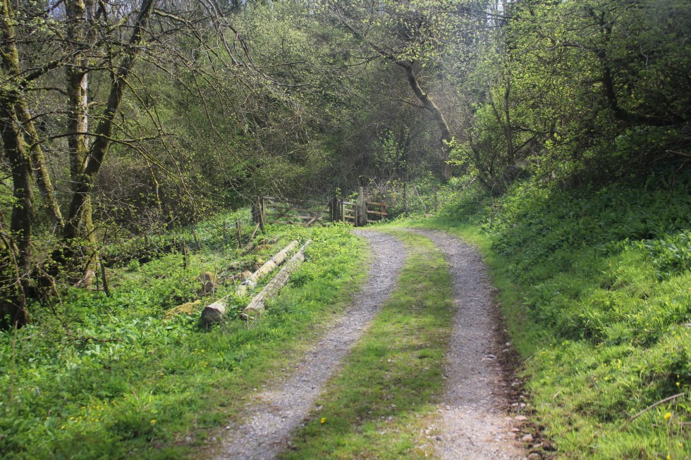
This is the last stretch of my walk around the Gower coastal path. I started this particular walk at Llanmadoc, which is three miles along a generally flat, but not always obvious, grassy and often muddy path.
Path to Llanrhidian
As I approach Llanrhidian, the atmosphere changes from rural scruffiness to urban tidiness; where the grass is kept short by electric mowers rather than by sheep. I pass along a path with a wooden fence along the one side. This seemed a bit of a shock after all the open spaces.
Llanridian itself is picturesque. It feels very much like a village that has been here for hundreds of years.
There is a unique church dedicated to Saints Illtyd and Rhydian in the village. The village that grew up around the 6th century church was founded by St. Rhidian, hence it’s name – “Llan” (meaning religious enclosure) “Rhydian” (the founder’s name). Rhydian dedicated the church to St Illtyd, another Celtic saint who was believed to have lived here. You may remember St Illtyd, he was the Celtic founder of the sea-side church at Oxwich and has many churches dedicated to him across Gower and South Wales.
Llanridian Church
The church that exists in the village today was built in 14th century. It has a holy well and something known locally as a “leper stone”, as well as a 11th century wheeled cross shaft near it.
Remains of Wheeled Cross
The so-called leper stone is a probably the remains of a door lintel, or maybe even or tombstone lid and dates from the 9th century. I probably did not have any connection with lepers was, other than in the imaginations of the Victorian who discovered it near the west tower doorway it in 1865 and subsequently had it moved to the church porch.
Leper Stone, Llanridian Church
According to tradition, when St. Illtyd lived on this spot as hermit, the sea often flooded the site, destroying the saint’s cell and chapel. Several times he built an embankment of mud and stones to protect himself, but in vain. He asked an angel to help him and the sea obeyed the saint, subsiding. He then struck his crozier on the dry shore and a holy well gushed forth, instantaneously. This well still flows today and is said to have curative properties. It is located in a private garden near the Church. It also known as the “milk well” or “butter well” , by locals, as in 1185 milk and butterfat was seen flowing in it instead of water, according to the Annals of Margam. This miraculous event was said to have lasted for at least three hours.
Here I joined the coastal road. The atmosphere changes back to the marsh wildness with the mild peril of possible flooding.
Flooding Warning Sign, Llanridian Marsh
It the only true coastal road on Gower. It skirts along the side of the wide marsh from Llanridian to Crofty.
Crofty in the distance
I could see Crofty off in the distance, but I wasn’t going to be fooled into thinking it was close because I could see it. I can see Port Talbot from Swansea Beach, it’s still 13 miles away an in no sense “close”. Same goes for Crofty. Turns out its three miles from Llanridian, which was possibly further than I realised when I decided to trudge it’s length. It figured, its flat. It’ll be easy!
The Marsh, North Gower
Well it was flat but it was also a very long road. It was a very empty road. I passed only three cars/vans and one cyclist in the two hours I was walking on it. The cyclist nearly ran into me when I walked into his path.
Lone Cyclist
I was my fault as I didn’t look over my shoulder when I heard a noise behind me, but I was very tired at this point.
Pergyl! Danger!
I stopped several times to take photos and enjoyed watching the light change as the clouds moved above my head. It may seem to strange to say, that this was probably my favourite part of all my Gower walks. Strange, it was very beautiful but I decided that I wasn’t going to paint this landscape. It’s too flat for my painting tastes. Maybe that’s why I enjoyed it all the more. It’s even hard to capture its essence in a photograph.
Llanridian Marsh
I haven’t attempted to paint it but I loved the sense of wilderness here that it’s present anywhere else along the Gower coastline.
Marsh Road, North Gower
At one point there must have been a lull in the cold wind and a silence fell and then I heard a rustling in the trees and bushes behind me and then a moment later, I felt its force. It was rather eerie to feel the force of nature.
Llanridian Marsh
Off in the distance was an aeroplane circling round and round the estuary off over Burry Port where Amelia Earhart landed all those years ago. Amelia was the first woman to fly (or be flown) across the Atlantic Ocean in 1928, when she flew across the Atlantic, this time as the pilot and on her own, four years later she landed in Northern Ireland.
I finally reached the village of Crofty.
Crofty, North Gower
It had a distinctly urban feel to it, not like Llanrhidian. By now had drunk both of my 500l bottles of water. I had very sore and stiff legs but I forced myself the trudge with purpose because I knew that I had about 20 minutes to make it to “New Road”, the main road, and catch the bus back home.
As I cut through the streets of Crofty, the roads all seemed unreasonably long but I eventually found the main road and I started walking in the direction of Llanridian. A bus shelter stop appeared.
A Miracle!
It seemed like a miracle to my tired legs. A bus appeared – a number 116 it its distination read “Llanridian” and not Swansea. I was so excited to see a bus with the number I was looking for I hailed it. The rotund bus driver looked at me slowly. No, this wasn’t the bus to Swansea. The stop for that was on the other side of the road. I looked across the road. So he pulled off and I crossed to the other side of the road, although there was no bus shelter or bus sign there. So I waited and waited. After about ten minutes, a school bus pulled up and some street-wise-looking teenagers got off. None of them looked like they were rushing home to do their homework.
Eventually, after I started wondering if Crofty had a taxi service or I’d have to stumble another two miles up the road to Penclawdd, a number 116 bus appeared. It said Swansea on the front. The bus indicated that it was stopping before I put out my hand to hail it. That was handy, I thought. I stepped onto the bus to show the driver my return ticket and as I glanced into his sour face, I realised that he was the same bus driver I spoke to twenty minutes earlier. Not a flicker of recognition passed over his face. I walked to the my seat, glad to sit down after 4 hours walking, chuckling to myself.
I had covered 6 miles and my feet were throbbing. It was a funny end to the walk. I had not seen the sea or river all day but I had smelt the salt and felt the wind. I had hardly seen a soul. It certainly the wildest and flattest part of the coastal path. I was glad it was over and my challenge was finally complete, Well, almost.
Post Script
This isn’t quite my last Gower coastal walk. I haven’t walked out along the causeway to Worms Head. However, you cannot climb to the top of the outer headland between the 1st March and the 31st of August – as it is closed in order to protect the many breeding sea birds, so I am waiting until September to do this final walk.
Below is a short video clip of the marshes near Llanmadoc. I’m afraid its rather poor, turn off the sound, but it’ll give you a good sense of of how vast and flat the marshes are.
When I get hold of an idea I can get quite obsessive about it. Lately, it’s been early morning light. I think it sprang from a post I wrote about transposing some of the techniques I used for my “Urban Minimal” project to what I only half-jokingly called “Rural Minimal”. I think that my rural Gower houses did fulfil the spirit of “Rural Minimal” but it got me think about shadows. Now, shadows were my first love. They still are. It’s hard to find any painting of mine without blue/mauve/purple/brown shadows. I go through tubes of Lukas 1862 Mauve at a steady rate. Many of my Gower woodland paintings used early morning winter light.
[wpecpp name=”Enchanted Wood Large Print ” price=”45″ align=”left”]
And why do I love shadows so much? It’s because they act as a foil to the light. The orange next to the dark mauve positively leaps off the canvas. Perhaps, its a cheap way of thrilling the viewer? I am always very impressed by artists who capture a gloomy or overcast landscape. Plein Air painters prefer overcast conditions because they are more constant and American artist, Jeremy Sams, demonstrates this really well in his painting. He says “The good thing about painting on an overcast day is that you don’t have to chase shadows. The light remains very constant and my acrylic paints stay wet for a good long while.”
Jeremy Sam’s Plein Air Study
However, I love shadows. They make a composition interesting and dynamic. So, anyway, the post about Rural Minimal got me thinking about shadows in rural settings. I realised that because I have been focusing on my Gower Walks and working to bus timetables that I was mostly walking in the late morning and finishing up in the early afternoon. I was becoming increasing frustrated that my lovely walks weren’t inspiring the sort of paintings I like to make. The light wasn’t right. Midday light, especially in the summer, has a tendency to bleach out the details. This is what shadows “do”, they show us the details of the landscape.
Light Shadow (SOLD)
I have always been a morning person. Each morning is like a fresh start to me. What ever happened yesterday, last night is gone.To be honest, I think that have always done my best work by 11 am. When I was writing my PhD thesis, many years ago, I’d do my best writing between at 8 and 11 am. To be honest, most of the work I did after 11 am was fact checking (this was in the days before the interest when you had to look things up in books) and faffing, but I’d dutifully stay at my desk til 5 pm.
Bernard Street Bus Stop (Back of Brynmill Launderette) SOLD
So I decided that I need to seek out early morning light on Gower. This long spell of hot weather meant that morning skies were often (but not always) clear. That meant getting up early. I have been dragging myself out of bed just after sunrise. It’s summer and the sun rises just after 5 am in here Wales. It is painful getting up that early but once I have had a cup of coffee I can face the outside world, just about.
The first time I drove down to Three Cliffs Bay, 6 miles away, I was so tired that I actually forgot my camera! I felt so stupid but I got back in my car and drove back home to fetch the darn thing, delaying my “start” by 30 minutes.
Pobbles Bay after 8am
Compare the light and shadows to yesterday morning (when I remembered my camera) and actually got there for about 6.30am.
Pobbles Bay 6.30 am
It’s different. Not necessarily better, just different. Do you know what, it doesn’t matter. I like both conditions. The changing tides always also variety and interest. Summer Morning light has a beautiful rich quality to it and I like seeing how it changes, the shadows shorten, darken, light break over the cliffs, as the morning progresses. I have sat down on the cliff tops and watch the light change.
Early Morning, Three Cliffs (SOLD) (Oil on Linen canvas, 80×60 cm, unframed)
I like seeing nature first thing. I like seeing the dew. In this very dry summer it’s a godsend. The grass on rolling fairways of Pennard golf course has turned the colour of straw except for the patches where the dew collects in the morning. There it’s a fresh green. Walking down towards the sea, along the sandy path by the golf course, I often see the white tails of wild rabbits dashing into the undergrowth. Their numbers in the UK have fallen in recent decades but thankfully, there seem to be plenty on Gower.
Welsh Wild Rabbit
Free-range cows roam the cliffs of Pennard and South Gate as well as the valley next to Three Cliffs Bay. They are usually busily eating the grass they can find down in the marshy valley or in the shadows of the thorny gorse bushes, or even in the Golf Club car park before the golfers arrive!
Cow at Pennard
Cows chewing the cud (mid morning) and cows at work, eating grass (early morning).
I delight in the long shadows and the reflections at low tide. How the reflected light is more golden than the light on the rocky cliffs.
Three Cliffs Reflections (SOLD Oil on Linen canvas , 80x50cm, unframed)
At high tide the colours all change again.
I have got up early and visited Rhossili, Penmaen and Three Cliffs Bay six times in the past fortnight. This includes the morning I thought the light cloud would clear but instead it thickened. A passing Jack Russell was photographed, as well as the rabbit above. So, I sat down and sketched.
I will keep going until this weather goes off, while may well be very soon. I will be working from this research for quite a while after it has clouded over again.
A while back, last June in fact, I read an excellent blog post by American artist Luann Udell entitled “How Long Did It Take You To Make That?” in which she discusses all time-consuming processes and skill that go into creating her pieces. It occurred to me that while the actual time it takes to paint my work may take anything from one to three days, depending on the size of the canvas, the actual thinking, planning, gestation, waiting for the weather and preparation takes a lot longer. I should also include in that waiting for the seasons to change. Just yesterday I was remarking to my husband that the heather was starting to flower and so another visit to Rhossili Downs would be in order soon. Nothing stays the same in nature, or in life! My job is to observe and attempt to capture some of those fleeting changes.
Enquiries about Commission Always Welcome – Find out more here
Last summer I started my series of “Urban Minimal” paintings of the streets of Brynmill, Swansea. These paintings were my “Hollowed Community” project which were exhibited in the that year’s Madeinroath Festival. That’s not a typo, by the way. The festival organisers stipulate that you type it as one word Madeinroath, rather than three “made in roath”. Roath is a suburb of Cardiff, by the way. They also stipulate that the “in” in “Madeinroath”has to be in red too. It’s driving my spell checker crazy!
My “rules” for composition and painting this project were:-
No cars
2. No People
3. Bright light. There must be shadows – at diagonals if possible.
4. Simplified forms – there must be little detail in the final painting. I want to explore the interplay of the geometry of shadows and man-made structures – the tension between the 3D buildings and the 2D shadows. Simplified blocks of colour.
These rules worked well in an urban setting, especially with the sea light we have in Swansea.
Since then, I have been caught up in my Gower Coastal Walk.
By my calculations, I have three, maybe four more Gower walks to do in order to complete the length of coastline but other commitments are keeping me from finishing. Firstly, I have a pile of exam scripts to mark. I am rusty and I mark slowly these days. Secondly, a summer virus has made me feel under the weather.
I haven’t consciously applied the urban minimal rules in a non-urban setting. What’s the problem? The applying Rule #1. “no cars” and #2 “no people” rules is easy enough. As is #3 “Bright light”. Then there comes the difficulty. The second part of Rule #3 “There must be shadows – at diagonals if possible.” Walking late morning, mid-day day means that there are few long shadows and they are difficult to find on beaches too. Although, there have been a few.
Langland (SOLD)
High Tide at Three Cliffs Bay (SOLD)
Finally, Rule #4 “Simplified forms – there must be little detail in the final painting. I want to explore the interplay of the geometry of shadows and man-made structures – the tension between the 3D buildings and the 2D shadows. Simplified blocks of colour.” I never really followed this rule to the letter as I thought details, such as window sills, and reflected light on glass, breathed life in pictures. It was knowing where to add detail and where to simplify that was important.
Coloured Sands at Three Cliffs Bay (SOLD)
Here, I have just been very cautious about going “too far” with this in a rural setting. But I have been edging that way, such as with my treatment of sand. Other aspects of my composition such as clouds and vegetation have not really been “minimal”, not in a conscious way anyway.
I think I need to challenge myself and make myself think about how I am tackling these subjects. I think my recent paintings of rural buildings (that’s cottages to you) has been much more successful.
Port Eynon Shadow (SOLD Oil on Linen Canvas, 46x38cm, unframed)
You may well say are just rural buildings instead of urban buildings. Yes, but they are stepping stones. I am still thinking about how I apply these rules when there isn’t a building in the picture!
Afternoon in Port Eynon (Oil on linen canvas 33x41cm unframed) (SOLD)
One thing I will say for Swansea Tourism is that they provide excellent free maps of the Gower. You can pick them up at “Information Points” around the city. I invariably have one folded into my pocket or in the front of my rucksack. They are small enough to be folded and stored easily like that. Not like my massive Ordnance Survey Explorer map of Gower. It’s about 20 years old so I don’t like to get it out unless I really have to. I am not very good at folded maps back into their original shape. Even the free map when is essentially a A2 sheet of paper (42 x 60 cm or 16.5 x 23.4 inches) printed on both sides causes me trouble in a good breeze.
I don’t really need my map today as the path follows the sea in a logical manner. The coast path signs appear at all junctions to make it clear which way I should be going. I do need the map to work out where something called the Knave is. The knave is a triangular slab of rock. I had come across a beautiful photograph of the Knave by Paul Edwards and was quite intrigued by it, as I had never come across it before.
The Knave – Paul Edwards 2012
I did not get to see the Knave from the same angle as Paul’s photograph on this particular walk.
The Knave from the coast path (west)
The Knave from the coast path (east)
From the coast path the Knave looks a bit like a dragon beginning to unfurl itself. I say that because there is a much larger dragon ahead, I am looking forward to seeing close up. I don’t have the time or energy to walk down to the Knave beach, today, I will leave that for another time.
The Knave
I carry on the path towards Rhossili and my attention is drawn to the houses and farms that lie away back from the cliff edge. You can see them from miles away and I wonder what they are like inside, looking out at the sea.
There is lots of wildlife to observe. I can hear a lark’s rising song and I see black crows. Dylan Thomas probably would described them as “bible- black”. I see a robin. I think on every walk I have been on I have seen robins, whether I am in woodland, by a wooded stream, on heath land or on on the clifftops, they really must be very adaptable little birds. I even see a rabbit; his white tail vanishing into the gorse. Apparently rabbits are a vanishing species in the UK, their numbers have fallen by 80-90% in the past 20 years so I am happy to see one out here today. I also see and manage to photograph a solitary tortoiseshell butterfly. Although, it is one of the most widespread butterflies in Britain, it too has suffered a decline in numbers.
Tortoiseshell Butterfly
It is lambing season and the path is littered with sparkling white-fleeced lambs, twins and singletons sunning themselves along side their mothers. Maybe it’s my imagination but many of them seems to be smiling as they relax in the sun!
The path passes a series of narrow gullies down to the sea, Foxhole and Butterslade, and then the magnificent Thurba Head, a headland with 200 foot sheer cliffs down to the sea.
Part of Thurba Head
View from Thurba towards Worms Head
View from Thurba eastwards – where I have just come from
Mewslade. Here there is a path down to the sea, there is also a long dry stone wall that trails down to the sea. It is in the process of being repaired. I stop to look at the stones and marvel at the craftspeople that know how to arrange the stones to make a sold wall, all without cement.
Round Mewslade
If you go down to Mewslade, at low tide there is a beautiful sandy beach but at high tide there no beach at all, just rocky cliffs.
Mewslade at Low Tide
Mewslade – tide’s coming in!
At low tide, you can supposedly walk from Mewslade to Fall Bay around the next headland. I think some rock climbing might be involved. When I tried it from the other direction (Fall Bay to Mewslade) I ended up with wet boots (it’s a long story.)
Waves at Fall Bay
After Mewslade I am getting excited as I can see Tear Point at the far end of Fall Bay. I have walked this part of the path quite recently and although I am getting very tired, I have a sense that I can do this. This long walk will be completed.
Tears Point off in the distance
Now onto the climax of this long walk; Worm’s Head. As historian Wynford Vaughan Thomas called it “the Land’s End of Gower”. Its still quite a way until I reach the bus stop in Rhossili but I am now powered on by the sight of the Worm (in Old English “Wurm” means dragon).
The Worm (left) and Coastwatch Station (right)
This curious dragon-like, tidal island snakes off into the sea. I have seen seals on the leeward side of the island. Between the cliffs and the Worm is the causeway, it is visible this afternoon. It is a rocky mess of rocks and rock pools, which is open for 2.5 hours either side of low tide. At low-tide, the causeway can be crossed to the island. It is usually fatal to attempt to wade or swim to from back from the Worm when the causeway is flooded or partially so. Sadly, people have died tried to do so.
It’s one of the jobs of the little Coastwatch station, perched on the headland, to stop people from risking their lives doing this. It’s a stout and sturdy single story building is made of granite. It has been sitting alone at the top of the high cliffs that look out towards Worms Head and beyond to Lundy Island and to the Celtic Sea for well over a century. It’s also looking out for fishing and leisure craft who might experience difficulties off the rocky shoreline. A team of local volunteers look after from the coastwatch station; from 10am till 4pm in the winter and 10am till 6pm in the summer. If at the end of watch the Causeway has not yet flooded and there are members of the public still out on Worm’s Head, the watch is kept open until everyone is safely back on the mainland.
Kitchen Corner is a small bay to the right of the path that leads down to the Worm’s Head causeway. The boathouse was built in the 1920s and is often used as a location for fishermen although there was no one here today.
I had looked at my watch and discovered that it had just gone 2pm. According to the notes on my post-it note there was a bus back to Swansea at 2.32 pm and then at just before to 4pm. I decided I would try and make the first bus.; It would involve a bit of a speedy march and by now I had a ranging thirst and I knew I would need to refill my lone water bottle somewhere. So I put my head down and forced my limbs to move as fast as I could along the long smooth concrete path from the Worm back up to Rhossili. A classic case of just because you can see it, doesn’t mean it close. It’s actually about a mile in distance.
Even as I am steaming along the path, I still have to pause and take a few photos of the incredible view across Rhossili Bay of Llangennith Beach. I pass people on the way, many different foreign languages floating on the breeze; German, Spanish, Chinese, Hindi. Of all the places on the Gower peninsula, this is the one that draws vistiors from all over the world, everyday, even on a day with bad weather. I love the international aspect of the place. It make me feel like I am citizen of the world.
I finally make it up the long path into Rhossili village. I also had time to stop off at the National Trust Conveniences to refill my water bottle. I am relieved to see that there is someone else waiting for the bus too. Always a good sign. An empty bus stop always has me wondering if I have just missed the bus.
It took me four hours to walk from Port Eynon to Rhossili. Was it 6 or 8 miles? It was probably 6 but it felt like 8, will all those ups and downs. I started the walk thinking about a slight twinge in my right knee – latter on I had forgotten that twinge in favour of my aching upper thighs (from going up and down hills), then it was aching calfs and finally whilst sitting on the long bus journey back to Swansea it is my feet that are throbbing.
So what did I learn today?
1. Remember suntan lotion. I should have put on suntan lotion. My right arm is burnt My left arm is fine. I now have a small tube at the bottom of my rucksack.
2 Water. Bring more water. Two bottles. Bringing enough water is more important than bananas, plaster, handbags and so on. I will bring two bottles on my next walk.
3. Finally, “Just because I can see it, doesn’t mean it’s close”. It’s now my walking mantra. However, it can be encouraging to see the end of your journey even if you are not there yet. This can be metaphorical as well are real – I can see the end of this journey now. I am over half way. I have walked over 18 miles out of the 32 or so I will need to do to complete this coast walk. I am buoyed by this feeling.
I have to pause in my journey around the Gower Peninsula because I have exam invigilation work for the next three weeks.
In my last blog I quoted Welsh Historian and writer Wynford Vaughn Thomas, who called the Gower Peninsula “a secret people hug to themselves”. Brandy Cove may well be the secret that the people of Bishopston “hug to themselves” because it’s a short walk down a lane from the village for them, but the secluded Pwll Du Bay is much bigger secret as it is only accessible to the public on foot, horseback or bike. Yet, its just along the coast from Brandy Cove.
Brandy Cove from the Coastal Path
There are two coastal paths you can take here, the one that hugs the coast gets quite difficult in places (so bad you have to use all fours to get up one bit I seem to remember) so I took the path that trails further inland and higher, hoping it would be less arduous.
I checked on my map to make sure that this was a legitimate path, this time. Yes, there are two paths.
I have to retrace my steps back up the path back towards Bishopston and then take the path through a field and up into some woods.
There is no sea in sight but I trust the map (and I have walkers going up this path so must led somewhere good).
Once I cross the field and enter woodland, the lands rises but fortunately there are a series of steps cut into the earth. These steps are a godsend as well used paths easily become quagmires, even in what seem to be relatively dry conditions (as is the case with the woodland path around Oxwich Head) .
The step are like a my very own Gower-workout. I have to pause three quarters of the way up, I pretend to myself its to check the view, but really it’s to catch my breath. At the top there is a wooden stile with a helpful yellow arrow signposting the fact that this is a an official path although not the coastal path. As I come out of the woods and onto the top of headland and I am rewarded with a fantastic view of Brandy Cove and Caswell to the east of me and Pwll Du Cove to the west.
I think about stopping to eat a jam sandwich and a chocolate biscuit but it’s starting to cloud over a bit so I decide to press on to Pwll Du in the hope that it will still be sunny when I get there. Once I cross another stile the path becomes wide enough for 4×4 vehicles. This track is not open to the public.
Once upon a time this track was a lot busier as this was part of the only route between South Gower and Swansea. As I round the corner, Pwll Du Bay comes into sight.
Pwll Du Bay
Pwll Du, means “Black Pool” in English. I have puzzled over how to convey how the name it sounds (as I am not a Welsh speaker), you can either go to google translate and type in “Pwll Du” and then click on the little speaker icon or accept my shoddy anglo-approximation of “Poulff-Dee” which does not really do justice to the breathy Welsh pronunciation. I’d welcome other people’s suggestions. I sit down by the river in the sun to eat my “elevenses” which consisted of two jam sandwiches and two chocolate biscuits. The healthy banana was left for later.
Anyway, Pwll Du is a bit of a puzzle. Here’s what looks like a little Brigadoon in the the middle of nowhere that is very difficult to get to. In Pwll Du. There are three houses, and as you walk into the Bay, you pass another house on the right that has been abandoned.
Part of the answer is in the seclusion of the place. Like Brandy cove, this was a good place for smugglers to bring ashore wines, spirits and tobacco. This carried on in the 17th and 18th century until Prime Minister William the Younger slashed the sky high duties on tea, wine, spirits and tobacco and taxed things like bricks and tiles but also things that rich people liked such as gold and silver plate, men’s hats, ladies’ ribbons, perfumes, hair powder, horses and carriages, sporting licences and most famously, light, or rather windows. If you have ever wondered why the Georgians like to brick up window, it was a form a tax avoidance! The other part of the reason why a tiny community grew up here was lies in the the rocks; The limestone.
The limestone quarry was to the right of the houses
Pwll Du Bay was ideal, it was made of limestone and had easy access by sea. Limestone was quarried here on a massive scale and up top 30 ships could be moored in the bay at any one time. These thirsty visitors were enough to sustain at least two public houses, “The Ship” and “The Beaufort”. There are suggestions that there may have been as many a 5 pubs in the valley! The abandoned house I passed may have been either ‘The Bull’ or ‘The Star’ and a pub called the ‘New Inn’ apparently lay some way up the valley on the Swansea side of the river . The two pubs on the beach were later converted into tea rooms but are now both private houses. The Ship Cottage can be rented as a holiday cottage.
Pwwl Du’s seclusion also meant that during the Second World War some of the several German submarines that secretly sailed up the Bristol Channel used to surface, under the cover of night, to collect fresh water from Pwll Du. Apparently, but no one actually saw them doing this so it may just be a good story.
Ship Cottage, Pwll Du SOLD
Pwll Du Bay is a sand beach smothered in pebbles and is a popular destination for local secondary schools’ Geography field trips. There were two schools here when I visited.
Field work in action
The river that snakes its way down the wooded Bishopston valley seems to be get swallowed up by the pebbles. This is quite odd. I think that this might be what the geography students might be studying. There is a tiny footbridge that crosses the river before it vanishes under the pebbles. I love the wrought iron flourishes that make me wonder if they used to be someone’s garden gate in a former life.
Crossing the Bridge at Pwll Du SOLD
Once I had crossed the little bridge I climbed up another steep path with those Gower-steps cut into the earth.
At the top of the path is a holiday cottage – there is a choice here either carry on the road for a slightly shorter walk or follow the coastal in a large loop around the top of Pwll Du Head, called High Pennard. This used to be an iron age fort and is one of the highest headlands on the Gower. Here the Gower-steps are surrounded by delightful posies of primroses.
The view is well worth stopping for. To the east is Pwll Du Bay (below left) and to the east looks towards Pennard Cliff and Cefn Bryn, which is the name of that russet sandstone ridge off in the distance (below right). Just below you, looking towards Pwll Du, is a cliff known as Graves End. Its called that because its near where a ship called ‘The Caesar’ was wrecked in 1760. Its a very sad story because many of those on board who drowned had not chosen to become sailors but had become “press-ganged” . In other words, they were kidnapped by the navy and forced the serve on the ship. We know that some men from Port Eynon were recruited in this way and “press-ganging” was an occupational hazzard for all young men who lived and worked near the coast. Tragically, when “The Caesar” sank , many of the press-gang men were locked below deck and so died when the ship hit the rocks. They were buried in a mass grave at Graves End.
If you follow the road, you pass this cottage with old fishing nets and buoys in the garden.
On the otherside of High Pennard is Deep Slade, or Hunts Bay. This is a bay I hadn’t visited before this coastal venture. Day trippers are discouraged from driving up this way by “Private Road” signs. Apparently, it was once a sandy beach, but the sand has pretty much gone, leaving a very rocky cove. The loss of sand has been blamed on sand dredging in the Bristol Channel.
Hunts Bay at High Tide SOLD
It was at this stage in my walk I decided I needed to answer the call of nature. There seemed to absolutely no one around. So leaving my rucksack by the road I clambered over a five-bar gate and got behind a suitable hedge. Of course, it was at this moment I hear the clip clopping of a horse and after a few moment a rider (female, thankfully) comes by. She can see my bag and she’s craning her neck to see what I am doing. Drat. I feel very silly. After a moment’s pause I wave to her and shout out to her that I am answering the call of nature (those were not my actual words but you get the idea). This seems to satisfy her and thankfully, she moves on. I wait awhile before I clamber back over the gate. Fortunately, she’s long gone by then!
It’s a ten minute walk to Pennard Cliffs and the bus but I’ll describe this part of the Gower Coast in my next post.
After my adventures on my first walk along (or rather off) the coastal path from Limeslade to Caswell, I was left with legs that were covered with scratches from the sleeping-beauty-brambles that smothered the path I was stupidly trying follow. I didn’t discover these until later on that day when I was in the bath. I looked down at my legs and marveled at all the scratches that I didn’t realise were there. I had walked just under 3 miles but I was very tired and very stiff the next day. My toes hurt, my legs were stiff and my back ached from carrying my rucksack. The going up and down hills is more arduous that you’d think.
It took a weekend’s rest and a sunny forecast to tempt me out again. It was the spring Equinox. The day when light and dark are balanced before the days lengthen into spring. I got up earlier this time and caught the 9.20am 2C bus on Oystermouth Road to Caswell. The same bus driver from my first bus trip to Limeslade was driving this bus.
Unlike the bus to Limeslade that snaked all around the houses Langland before it reached its destination, the bus to Caswell is pretty direct, travelling through the villages of Mumbles and up a hill into Newton then before the long descent of Caswell Road, past the Summercliffe Chalet park with its very expensive chalets (£150K to buy one, if you are asking). There are some very different chalets nearby, tucked away in the woods and easily missed. These chalet fields are Holtsfield and Owensfield. They started as holiday huts but became permanent homes after families were bombed out of their homes during the second World War.
At the bottom of the hill is the beach. Caswell is a very popular beach with locals and tourists alike. In the summer the car park fills up and if you leave too late in the day, they close the car park and you just cannot get in!
After School
When I arrived at Caswell the tide has just turned. High tides make a big difference to how much beach there is here and all along the Gower coast. This is because the Bristol Channel has the second-highest tidal range in the world. The low tides expose vast stretches of golden sands while the high tides flood the bays create cozy bays of sheltered water. When the tide is out there is more than enough beach for everyone.
This morning, however, the high water meant that Caswell Bay was cut into two small bays.
So why are there two bays at Caswell? Apparently it because there are two neighbouring faults, one along Caswell Valley (beneath the car park) and another directly under that ugly block of apartments behind the western arm of the Bay. At the foot of the western cliff (called Redley Cliff) runs a small brook, which starts at nearby spring. In the past water from this stream was stored in a massive concrete cistern and supplied to the houses of the bay by gravity-feed from a wind-pump situated on the top of the cliff. You can just about make out the windmill on the top left hand-side of the old postcard below.
We have a wonderful insight into what Caswell used to look like in the mid-19th century, thanks to photography pioneer, John Dillwyn Llewelyn. John was what you might call a Victorian playboy scientist. He was very rich did not have a “proper job”. His father Lewis Weston Dillwyn managed the family-owned Cambrian Pottery in Swansea. This meant he was in the very lucky position of being able to pursue his interests in science, botany and astronomy full-time. John’s wife, Emma, was the cousin of pioneer photographer William Henry Fox Talbot and this clearly inspired John to take up this new science. John actually became a one of the most important amateur photographers in the 1850s and he took photographs of the holiday home, Caswell Cottage, he built at Caswell.
Caswell Cottage
He was also an inventor of new techniques. One of his innovations was a camera shutter that allowed him to capture the movement of waves at Caswell at approximately 1/25th of a second.
Redcliffe Appartmments
These photographs of an unspoilt Caswell make me sad because in the 1960s the local planning authority decided that this beautiful bay would be “improved” by the knocking down Caswell Cottage to make a car park and also knocking down Redcliffe House (once home to the family of Dylan Thomas’s poet friend Vernon Watkins) to build the brutalist-style Redcliffe apartment block. As my husband says, “I like 60s’ architecture, but it’s like an office block has been randomly dropped into the countryside”. This makes painting nice paintings of the bay difficult because the 1960s block, in my opinion, is not very pretty. It might be great to live in, with lovely views, but its not great to look at, or paint.
Bay House, Caswell
Still, at least we are still left with the handsome Bay House. Three sisters Emma, Agnes and Alice Morgan built and lived in this house in 1877. The sisters also planted many of the bay’s distinctive pine trees.
If you look closely at the photo to the right you may well be able to spot a helicopter. This house is currently owned by the flamboyant boss of the Welsh supermarket chain “CK’s” who is a keen helicopter pilot. He’s got into trouble a few years ago when he flew his helicopter into Heathrow airspace and caused a security alert. In Chris Kiley’s defense he was late for lunch at a nearby country house, and although he’d been given directions he didn’t have coordinates! Its seems that he’s gone off living Caswell because the house is up for sale for £2.5 million (that’s around $3.5 million dollars).
Today, the tide was in, so I had to walk along the road, to find the coastal path. Usually I’d walk across the beach and climb up the cliff path, which is what I did in 2016 (see photos below).
I decided to take the higher path and this time I was determined to follow the map. I find it hard to follow instructions, I don’t know whether its my sense of curiosity, laziness or plain stupidity that makes me think I know a better way. Mind you, looking at my Pathfinder Guide, I realise why I find it so difficult. Although the maps are useful, the rest of the page is pretty much solid text, no gaps, bullet points, paragraphs, so its difficult to follow. No wonder I just look at the maps!
Not today. My coastal path map (picked up for free from one of those information points in Swansea) has no instructions just a big map on both sides of the page. That suits me just fine. The map tells me that the path joins the road further up the hill so I start walking. This road, however, does not have a pavement for pedestrians for much of its length so I have to keep stepping back onto a narrow grass verge when cars pass by.
View From Bay House’s Driveway
Eventually, towards the top of the road I find the path and follow it although it did not feel very “coastal”. In fact the path takes a short cut across Redley Cliff and down a long flight of steps cut into the earth to Brandy Cove. I love going down steps like these.
The woods on the way from Bishopston to Brandy Cove inspired an early painting of mine; Brandy Cove Stile (see below).
Brandy Cove Stile
Writer Wynford Vaughn Thomas called the Gower Peninsula “a secret people hug to themselves”. Brandy Cove is bit of a secret places in Gower because you can only get here on foot. You can walk down narrow lanes and paths from Bishopston village or via the coastal path. It is a little cove that is made of mostly pebbles and rocks at high tide but at low tide looks very different as golden sands stretch out into the Bristol Channel. Its a lovely place to swim in the summer and usually deserted.
I had read somewhere that it used to be known as Hareslade. All the locals call it Brandy Cove, however, thanks to the pirates/smugglers who used to maraud the length of the Bristol Channel and unload their illegal tobacco and alcohol goods here during the eighteenth century. Think Ross Polark with a Welsh accent and you’d be about right.
Brandy Cove at Low Tide
In the 19th century Brandy Cove was later home to a silver and lead mine, although mining had probably taken place in this area in Roman times.
One of the mine shafts was put to a much darker used in the early part of the 20th century when the dismembered body of Mamie Stuart were dumped by her murderer. Mamie, from Sunderland in the industrial North East of England, was dubbed a “chorus girl” by the local press. She had been used to a life on the stage but she’d given that that up and married Cardiff-born George Shotton in 1918 and moved to Swansea. The marriage was mistake. It was a very unhappy one and Mamie wrote to her parents complaining that her new husband beat her. After these complaints they heard no more from her. She vanished.
Her suitcase turned up in a Swansea hotel. Despite a national serach, she was never heard of again. It turned out that there was already a Mrs Shotton who was living in Cardiff with a daughter. George did 18 months’ “hard labour” in prison for bigamy, but the cad got away with murder because by the time her remains were discovered in Brandy Cove in 1961, he had been dead three years. Poor Mamie.
In my next post I carry on and visit one of Gower “hidden” villages and visit a Gower bay that many people have never heard of.
This was all my sister’s idea. She suggested I walk along the Gower coast and paint the bays and beaches. I had no idea how difficult the logistics of this would be. I had the daft idea that catching buses and walking the coastline would be easy. After all I had a jolly looking-leaflet “Gower Coast and Countryside with out a Car” with a photo of a bus on the front.
Sadly, it turns out that Swansea Council have changed their mind and aren’t that keen for walkers to come and visit this “Area of Outstanding Natural Beauty” (since 1956, you know).
Closed
I’d picked up that leaflet two years ago. I had called into the Swansea Tourist Office, sensibly located next to the bus station. There were two helpful ladies who gave me lots of leaflets where told me where I could get up to date bus timetables.
When I tried to revisit them last week, however, I was horrified to discover that the office was closed. There was no notice about where to get tourist information. Swansea council claims that 11,100 people are employed in tourism in Swansea but they can’t find the money to fund two people and some leaflets in a tourism office!
Bus Station Info Point
Not to be defeated, I called by the bus station, in the hope of getting up-to-date timetables for Gower bus services. I had to wait several long seconds whilst the youth on the information desk pondered over his suduko puzzle, sighed, and looked up. When I asked about buses round Gower he tore off two A5 sheets of paper for the week-day buses to North Gower and to Rhossili. He then went back to his puzzle. I wasn’t filled with confidence about getting around the coast by public transport.
Tescos
I went home to look up on the internet where the office had been moved to. It hadn’t; it was gone. The tourist information office in Mumbles has been closed too. I emailed the tourism people for help. I was tartly informed that information was moved online and supplemented by a series of “information points” around the city where I could get help. I initially thought that these might be sort if dedicated tourism-related computer terminals. turns out that these “information points” are leaflet racks. I wqs informed by the tourism person that they were “a network of Visitor Information Points (VIPs) across the destination, offering a drop-in facility for visitors with plenty of advice, maps and leaflets at the ready!” I didn’t feel very encouraged by this. So I went back into to town to have a look. The first information point I visited was in the foyer of Tescos. There was no one to speak to here.
Grand Theatre
I then visited the foyer of the Grand Theatre where they had a number of racks filled with leaflets. There were staff there. They were sitting behind a glass screen at a counter. There was a queue of people waiting to buy tickets. When the queue went so did the counter staff. I lost heart. I didn’t think they’d thank me for asking them about buses to Port Eynon and I knew that they’d direct me to the bus station, so I left. Whilst was at the Grand Theatre, I did pick up a leaflet which spoke volumes about Swansea Tourism’s much reduced ambitions for tourism the area.
Instead of “Gower Coast and Countryside without a car” it’s now “Mumbles and the City of Swansea without a car.” Swansea and Gower really need the money that tourism can bring to the local economy but the local council just fail to provide the infrastructure that is needed. I’ll come back to the issue of bus timetables later, as it is something that has kept me awake at night trying to figure out how to go and get back from places in Gower.
Caswell to Mumbles Head
Limeslade. This is where I decided to started my Gower Coastal Walk in 2018. The “First Cymru” buses from Swansea Bus station run every hour along Oystermouth Road. It is a very good service. As a shy teenager I had a terrible fear of speaking to bus drivers. Not anymore. These days, I gabble at them and give them long questions about the right ticket and the correct time.
My first bus stop
The bus travels along the seafront road to Mumbles and then snakes its way around the bungalows of Langland. Many cheerful white-haired passengers got on and off the bus with their bus passes. Many of them seemed to know each other and they chatted away to each other and waved at friends out of the window. The sunshine has cheered everyone’s spirits. Finally, at the bottom of Plunch Lane, the sea reappeared and I dismounted.
The bus at Limeslade
Here there is a little rocky bay called Limeslade Bay, which is a five minute walk round the corner from Mumbles Pier and Bracelet Bay.
Why is Limeslade called Limeslade? Well, limestone is a big feature of the Gower landscape. From Mumbles to Oxwich, the coast is made entirely of Carbonifeous Limestone that has been faulted and folded. There are many little valleys along the Gower coast called “something-slade” and that’s what “slade” means -in an old English word (“slaed”) meaning a low valley, dingle or an open space between banks or woods. Which might surprise you that a Welsh coastline has so many names of Old English origin rather than Welsh. This reflects that fact that Norman landlords claimed the more fertile southern part of the peninsula and left the wilder, less profitable northern parts to the Welsh.
There are two paths you can take from here. There is the official Coastal path which snakes along above the sea following the many inlets. I have taken this path many times before.
The Coastal Path
The second one, sneaks up alongside the left hand side of Fortes ice cream parlour, up a steep muddy track onto the Rams Tor. This is the path I took.
Forte’s, with the steps to the higher path to the left
It is worth the climb. There is a great view of the lighthouse and the Coastguard station, and if its clear enough, further across Swansea Bay to to Port Talbot and Porthcawl.
Mumbles Lighthouse from Rams Tor
This is where the coast feels more like West Wales. The stubby trees and gorse bushes all lean lean to the left thanks to the prevailing westerlies. Once on the headland the walk is quite easy, if not a bit muddy. You pass by a few of the houses that lookout over the sea but as you carry on further along the path, the houses recede, with fields in the way. Quite quickly, Langland Bay comes into view. I love the view of the coast where you can see the bays of Gower off into the distance.
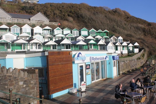
Rotherslade
Rotherslade
There is a small cove before the main sweep of Langland Bay. This is Rotherhide. Beteen the two bays is Storrs Rock which the French Impressionist painter Alfred Sisley painted in 1897 whilst on staying at the Osborne Hotel, which overlooked both Langland Bay and Rotherslade Bay, which was also called Lady’s Cove. His stay here must have been very a bitter sweet. He had come come to marry his partner, so as to legitimize their two children, but both he and his wife were dying of cancer. He painted Storr’s Rock at many times of the day.
Storr’s Rock 2018
Storr’s Rock (2018)
Langland
Langland Bay
Langland Bay is very popular with surfers and day trippers but its unusual for modern day sea-side towns, as it has not been hollowed out by holiday lets. That’s because Langland is an expensive place to live and its tiny lanes are often filled with Mercedes and BMWs. Wales’s first millionaires, the Merthyr iron-masters the Crawshays, set the tone in the mid-19th century when they built their massive summer residence here. It was originally known as Llan-y-Llan and looks as if it was ripped intact from the Scottish Highlands. It was later part of the Langland Bay Hotel but is now called Langland Bay Manor and been converted into swanky apartments that wont leave much change from £300K.
Old Postcard of LanglandLangland Bay 2018
The clean lines of green and white beach huts have become another status symbol. These striking green and white huts were built in Victorian and Edwardian times. They used to be dolled out to families on a lottery basis, at the very reasonable price of £236 for a three months lease. More recently, however, a cash strapped council decided it would raise money by selling some of the refurnished hut’s leases at a whooping £10,000. You would get to use of your hut for ten years and although the huts can be used every days of the year, you cannot sleep in them in overnight. I don’t know if anyone checks this! None of the huts were in use when I walked past but it was a chilly midweek day in March.
Langland from Snaple Point
Gower Coastal Path from Langland to Caswell
I continued my walk around the bay and again instead of following the official Coastal Path, I climbed up Newton Cliff which is alongside Langland Golf Club to look across Langland Bay.
Langland Bay from Newton Cliffs at Sunset
After the climb up Newton Cliff I was starting to get tired. This is when I made a stupid mistake. I left the beaten track. In stead of following the footpath down the hill to rejoin the official coastal path, with its easy tarmacked surface, I decided to try and follow what I thought was a path along the top of cliff along the edge of the golf course. The sun had gone in and it started to spot with rain. This was a disaster, I ended up struggling down paths covered in brambles sleeping-beauty-style, only to eventually admit defeat and retrace my steps. It was a long detour. I ended up asking directions from some rather bemused looking golfers. I could tell one of them wanted to tell me off for being on the golf course but I was apologising so much, he just said “you shouldn’t really be here” and then directed me back to the official path.
By the time I reached Caswell Bay, I was very tired indeed. I had eaten the single banana I’d brought to eat long ago so I queued for minutes in the very crowded “Surfside Cafe” and bought a chocolate ice-cream which revived my spirits considerably. I then waited at the bus stop for the hourly bus back to Swansea.
What I learnt
It hard to write notes on a bus.
Take sandwiches.
Stay on the beaten track – if there’s no post it’s not a path.
Look at the map – put it in your pocket, don’t leave it in your rucksack.
Leave longer than you think
Leave the book on Gower History at home. It’s heavy.
Don’t believe the weather forecast. It can go from warm sun to wind and rain.
Most importantly, check your camera lens for smudges. Most of the photos I took today were no good (see below).
Langland Bay with smudge on the left side of the lens!
What I got right
Coat with hood
Walking boots
Bananas are great
Water bottle – its heavy to start with but you end up drinking most of it.
Next post – Will lots of chocolate biscuits see me through to see the stunning views from Pennard Cliffs?
P.S. Here’s some drone footage of the coast and Langland Bay (BTW The sea isn’t usually this colour)
I love looking at maps. I have been gazing at the map of coastal path around Gower for days now. The Peninsula juts out westwards into the Bristol Chanel. Its about 17 miles in length and 8 miles width at its widest point. I am planning to walk around its coastline, approximately 38 miles in length, maybe a bit less.
I am, however, going to start with a map of Swansea Bay. People who have never been to Swansea make jokes about the place as if its somewhere to avoid. Quite the opposite. The hilly city sits alongside the sparkling sea and beautiful sandy five-mile beach.
Swansea Bay
I have decided to illustrate this series of post with my paintings and with (mostly) my own photographs. The paintings have been completed in recent years, some as a result of this trek, other are older. The photos are mostly from 2018 but a few are from my 2016 attempt to walk the Gower coast. I started my first attempt at Mumbles in 2016.
The pretty Victorian village of Mumbles sits at the far end of the western arm of Swansea Bay. This is where my journey around the Gower coast begins.
Round Mumbles Bend
Mumbles was originally a fishing village. It did not catch fish but rather, oysters. It was, for a time, a thriving industry. Part of Mumbles is known as Oystermouth and many people often use the two names interchangeably to mean the same place.
The Strange Afternoon (Mumbles & Oystermouth Castle)
Many people often associate South Wales with coal mining, and coal was certainly vital in locating the copper industry in nearby Swansea. It was the need for limestone, however, that changed Mumbles’ fortunes. Limestone was used as a fertilizer, in steel making, pharmaceuticals, and also as a construction aggregate (in other words, gravel).
Tide’s In (Mumbles)
Mumbles was made of limestone and that fact brought the modern world to the front door of this tiny fishing village in 1804 when the Oystermouth railway line was built in order to transport limestone from the quarries of Mumbles to Swansea Docks. This track was the world first passenger line, the Swansea and Mumbles Railway, carrying at first horse-drawn carriages, and later steam locomotives.
Mumbles Pier from Knab Rock
The trains also brought many day trippers for a time. The railway is now long gone, closed in 1960, but there remains a sturdy promenade that runs along the sea front where the trains used to run. Locals and visitors alike still love to walk its length and admire the spectacular view across the sweep of Swansea Bay.
Afternoon Stroll in Mumbles
The promenade runs up to Verdis, a popular ice-cream parlour and thence to the Mumbles Pier. The Victorian pier was built in the last years of the 19th century and was the last stop for the Railway. Here tourists could catch a paddle steamers for a tour along the River Severn and Bristol Channel. The Pier hosts a great cafe (with self-playing piano), an amusement arcade and tiny art gallery.
Mumbles Pier
On the other side of Mumbles Head is Bracelet Bay. Mumbles Head comprises two tidal islands. At low tide those with stout boots can walk out to the islands and look at the much-photographed lighthouse.
Towards Mumbles Lighthouse
The octagonal lighthouse lighthouse was built in 1794 by Swansea architect William Jernegan, who also designed Singleton Abbey which later became part of Swansea University. This was the second attempt to built a lighthouse here. The first one started a few years earlier, designed by someone else, collapsed before it was even finished!
This is where the real Gower coast walk begins! In my next post I puzzle over myriad bus timetables and eventually feel brave enough to leave the car behind! In the meantime here’s a cool video of a drone flying around Mumbles Head. https://youtu.be/MvGQhPzQlKo


 The people of Britain love their dogs. It is no secret that I love animals. I come from a family of animal lovers. My younger brother has three cockerpoo type dogs, my sister has a Cocker Spaniel called Dolly one and myself and my husband have two gorgeous mutts.


")


 One of the mine shafts was put to a much darker used in the early part of the 20th century when the dismembered body of


")


