“Is this a fast painting or a slow one?” My husband asks.
This question gives me pause.
“A fast one” I reply.
Portnoo Colours (Donegal) by Emma Cownie
My paintings usually take days to complete. On average three days. A smaller one quicker. Commissions are still “slow” paintings.
Lately, though I have taken to completing paintings in a single sitting. This may well be several hours, but its a single sitting.
Rocky Ground Bun An Inver by Emma Cownie
The results are more sponanteous-looking. The process feels slightly out of control. Often I think “I have bitten off more than I can chew” here. But I stick with it. Years of painting have taught me to ignore the impulse to give up. To push on, even when when it looks a bit ugly.
There may well be things wrong; colours or details but they dont matter too much. I will alter them if they really bug me. Mostly I dont. The brush strokes are broken and incomplete. In some places they are deliberately rough. The canvas shows through in places. Often I am uncertain if I like the painting when I stop. Its usually a bit of a surprise. I have to fight my perfectionism.
Narin Rise, Donegal by Emma Cownie
I am racing ahead of my thoughts. Ahead of my critical mind that tells me its not good enough and to keep painting. Now I refuse to listen and keep going. It’s intense and exhausting.
Over Cruit Island, Donegal and painting by Emma Cownie
My father died in June this year. He was 92. My heart is broken. He was a lovely, funny and kind man and I miss him terribly.
The name will be familar to British ears who ever listened to the daily shipping forecast on BBC Radio. It is broadcast late at night just before 1 am and very early (5.20am). Anyone who is a night owl or insominiac will have listened to it. The list of shipping zones and forecasts is not only practical but also poetic and rather mysterious. Following the litany of locations and numbers is very soporistic. Listen to the clip below. The actual broadcast is from 2.46 onwards ZZzzzzzzzzz
Shipping Forcast (1993) – almost always broadcast on the radio, you have to use your imagination!
Many British people may not know where Malin Head it is anymore than than they know the location of German Bight or Viking. To Irish ears, however, it is well-known as the most northerly tip of the island of Ireland and also features on Met Eireann’s, sea area forecast, broadcast on RTE.
UK_shipping_forecast_zones
Malin Head to Mizen Head
People regularly tranverse the length of Ireland from Malin Head, Donegal, to Mizen Head, Cork. It’s a fair stretch. Just under 400 miles (640 km). Some incredible people have cycled it in just over 15 hours. Ordinary mortals take about 4 days.
Amazingly some super-human runners have done it in about the same time – 4 days! I recently listened to a radio interview with the heroic Sophie Power. Sophie is from England and she recently ran the length of Ireland in under 4 days. This is a World Record. She beat the previouis record by three hours. Being a mother, she had to fit it in during her children half-term holiday and didn’t get to pick the day with the nicest weather – just the Tuesday of half-term and so she started off in driving rain! Many years ago I used to run (only piddly 10ks and 5ks) and I would certainly prefer to run in rain than heat.
Incredibly Sophie ran most of the distance without sleep, snatching the odd half an hour on her second and third day. She ended up hallucinating, and with a knee injury that had to be braced. When she finished the race in Cork she had developed heat stroke! That alone shows you how far south Cork is. There’s no way she’d get heat stroke in Donegal! She’s planning to come back and run the Cork Marathon.
Sophie Power at Malin Head
At the Edge of the world
Standing at Malin Head is like standing at the edge of the world. To the north is nothing can be seen but sky and sea. A long way off is Iceland and much. much further away to the north-west is North America. It feels very remote (but surprisngly accessible from Letterkenny and Derry/Londonderry) but to fishermen and sailors, I’m sure it’s not. Scotland is surpisingly close to the north-east. If you have ever flown from England to Belfast on a clear day, you can see the Scottish Isles and the Isle of Man scattered across the Irish Sea, pretty close the Antrim coast. Donegal is just a bit further along.
On the most northerly tip of the island of Ireland, you will find a tower that was built in 1805 during the Napoleonic wars as a lookout tower to defend against any attacks by the French. You can see at the top left hand side of my painting above. Edges of places are places to look out from – for invaders, or for incoming storms. Weather reports that were important to local and international shipping were first recorded at Malin Head in 1870. It was in that year the tower became a signal tower for Lloyds of London. Semaphore was used to connect with ships at sea and the lighthouse on nearby Inishtrahull. In 1902 the first commercial wireless message was sent from Malin Head to the S.S.Lake Ontario by the Marconi Company.
Divers’ magnet
There are the wrecks of many ships lying off the coast in this area. Many of these such as SS Audacious, SS Carthaginian and RMS Justicia date to the time of the First World War, when Ireland was still part of the British Empire.
In 1917 two German mines sankLaurentic and although her crew successfully abandoned ship, but 354 of them died of hypothermia in her lifeboats.Interestingly, Laurentic was carrying about 43 tons of gold bars when she sank. Most of the 3,211 bars were salvaged by 1924; three more bars were found in the 1930s, however 22 gold bars have still not been recovered.
The Great Emergency/Second World War
During the Second World War, Ireland was neutral. The Irish army built lookout posts in places along the coast to prevent any violation of this neutrality. This was important as this part of Donegal is so close to Northern Ireland, which not not neutral and was bombed by the Germans. There is an EIRE 80 sign built of stones during the war so aircraft would know that they were over Ireland (not Northern Ireland). They acted also as a navigational aid for pilots. Eire 79 is at Fanad Head to the west. Eire 81 is at Glengad Head, further along the Inishowen Peninsula, to the east. You can see it on the map below. The SS Athenia, a passenger ship carrying 1,418 people was torpedoed by a German U-boat just hours after war had been declared in 1939 off the coast of Malin Head! Most of the passengers survived but 117 perished.
Tourism Sign at Malin Head
Some scenes from the film Star Wars: The Last Jedi film was shot at Malin Head. I have to admit that I am not a Star Wars fan – I never made it through awhole film. I have to admit that I’m more of a Star Trek fan. Apparently, it is possible to have a tour of the locations used for the film from local tour guides. The road leading up to Bamba’s Crown has been renamed locally from the R242 to the R2D2 in recognition of the Star Wars connection. Also beside the tower, there is a short lovely refreshing walk along the cliffs to Hell’s Hole. The cliffs are massive here and even on a relatively calm day the sea is restless and a bit intimidating It needs to be remembered that this not just a sea here but an Ocean.
Birds Eye View of Malin Head, Donegal- Emma Cownie
There is a unique architectural gem, perched upon the high cliffs above the shores of the north Derry coastline. It is an elegant Roman-style round temple; a beautiful rotunda. It is a wonderful surprise. There is none other in Ireland. It looks out across Lough Foyle to Donegal to the north and on a clear day the Scottish Isles can be seen to the north-east. This remarkable building is Mussenden Temple.
Mussenden Temple from Downhill Strand
It was built by the eccentic and extravagant Earl Bishop of Derry, Frederick Hervey (b.1730-1806). The 18th century is full of mischievious and surprising characters and he’s one of the best. Frederick Hervey was in turns controversial, revolutionary and yet both shocking and popular in his own life time. He came from an aristocratic English family, the 3rd son of an earl with big estates in Suffolk. Having two elder brothers he probably never expected to inherit from his father. He first tried law and then became a vicar hoping for a career in the church. His family connections helped a lot. He became chaplain to the king, George III in 1763, who later called him ‘that wicked prelate’ .
When his eldest brother George became Lord Lieutenant of Ireland in 1766, he managed to wangle the post of Bishop of Cloyne for Frederick and then, shortly afterwards, in 1768, Bishop of Derry, one of the wealthiest Irish sees.
Frederick threw himself into being Bishop of Derry, reportedly visiting every parish in the diocese and embarking on a number of notable building projects in the city of Londonderry including building St Columbs Cathedral’s first spire (it had to be replaced later as it was too heavy) many fine building and the first (wooden) bridge over the River Foyle, earning himself the nickname ‘the Edifying Bishop’.
In 1779 his brother George died and Frederick became the 4th Earl of Bristol, inheriting an income of £20,000 a year. He now even more money. He spent a fortune on building and collecting art.
He was widely travelled and had a fine appreciation of art, especially Greek and Italian. He spent 18 years of his life in Italy and spoke Italian fluently. Frederick was also well-read and he was an expert in flora and fauna and publicised The Giant’s Causeway. The Earl Bishop did extensive research into the origins of the Causeway and promoted his findings to the scientific community and wider world.
He also visited Staffa Island on the Western Isles of Scotland to confirm the links with similar columnar formations. In 1782, he was made a Fellow of the Royal Society for his efforts.
The Earl Bishop was a colourful character and was clearly someone people loved to gossip about. There are many examples of his eccentricity. It is said that he made his clergy run a leapfrog race on Downhill beach to see who would win the best area!
He had an eye for the ladies and was reputed to have had several affairs. Among his mistresses was society beauty Madam Ritz, as well as possibly Emma Hamilton who was also the mistress of Admiral Lord Nelson.
Bramante’s Tempietto, Rome 1502
It was on his tour of Europe that he fell in love with Bramante’s Temple in Rome. He reportedly tried to buy it and have it moved back to Britain but the Pope would not let him. So the Frederick Hervey built his own. Several of them. He built Ballyscullion, near Bellaghy, Co Derry, in 1787 to his own extravagant designs. The façade was inspired by St Peter’s in Rome, and measured 350ft across, with a central rotunda flanked by curved wings and a large pavilion at each end. It sadly, no longer exists.
Ballyscullion House
He also started Ickworth House, in Suffolf in 1795 which was completed by his successors.
Ickworth House, Suffolk, England
His first rotunda, however, was Musseden Temple, built in 1873. It was built as a library on the cliff edge of his estate at Dunbo, County Londonderry, Northern Ireland. Dunbo derives from the Irish Dún Bó, meaning ‘fort of the cows’. Dunbo was renamed Downhill Demense and an incredible 300,000 trees were planted on the estate; although there is little sign of them today.
A huge castle was built with the assistance of number of architects (Frederick kept firing them) including Michael Shanahan of Cork and Placido Columbani of Milan, who was supervising plumbing and the installation of water closets, a swanky innovation for the time. So we are not entirely sure who designed the rotunda/temple on the cliffs.
Mrs Daniel Mussenden (born Fridiswide Bruce, d.1785) Unknow French artist c.1780
The temple was dedicated to his lovely young cousin Frideswide Mussenden (neé Bruce) who had recently married the rich banker, Daniel Mussenden, had given birth to a child. The temple was meant to a be delightful retreat for her to escape to and look out at the wonderful view or read some of the many books there. A fire was kept lit at all time to save the books (and her) from the damp Irish weather. Sadly, Frederick’s terrible reputation with women meant that their “friendship” was gossiped about, in the press. The fragile Frideswide was horrified to be written about in the Freeman’sJournal, even if she wasn’t mentioned by name, and it may well have supposedly sent her into a physical decline, dying at the age of tender age of just 22 in 1785.
There is a minature of her in the National Gallery of Ireland painted when she was 17 in 1780, presumably when she had just married Daniel. She has a very sweet and tender face; you can easily imagine her upset at the nasty rumours.
So the library on the cliffs is a poignant place. Built for a young woman who perhaps only used it for a short time before she died. It was always close to the cliff edge, reported 30 foot away when it was built. I think that is an exaggeration, as maps from the early 19th century do not show that much land between the temple and the cliff edge. The cliff has eroded and about 20 years ago the National Trust did extensive work to stablise the cliff and underpin the temple.
OSNI 1831 Downhill
I am very bad at remembering to take work in progress photos of my work. I often get too caught up in painting the piece. I am also usually very anxious about a painting until I have practically finished it!
This is a painting done with acrylic paints. I work with thin layers of paint, building up the colours and adjusting them, lighter or darker with each new layer. Often I like the painting best when its about a third done – I am confident I know where I am going with it and it still has “potential”.
Here there are still some “problems” to solve, the shadow on the temple needs to be darkened.
Frederick Hervey was a fascinating man, who had a long and varied life and I could write a lot more about him. He was minor celebrity in his day, he travelled widely on the Continent, where he kept company and correspondence with leading philosophers, princes, politicians, scientists, artists, architects and writers—including Voltaire, Goethe, Benjamin Franklin, John Strange, Jeremy Bentham, James Boswell and the Pope. He has been described as “a bad father, and worse husband, a determined deist, [who was] very blasphemous in his conversation”.
Yet he was a generous man who treated the people of Derry well, whether Catholic, Protestant or Non-Conformist (a type of Protestant that was discriminated against by the state at the time). He argued all his life for religious tolerance.
Earl-Bishop with His Granddaughter in Gardens of Villa Borghese c1790 National_Gallery_Ireland.
He believed the answer to the Irish question or the Irish problem of a disaffected Catholic majority is, was not meanness but generosity. Just as God wins our prayers of thanksgiving by His extravagant generosity, so England could learn how to win over Irish Catholics by giving them more, not less. He bankrolled the first Catholic chapel in Derry—Long Tower Church—and personally chose the magnificent Italian marble that adorns the altar.
He undertook public works to relieve poverty, and was a generous patron to the Catholic population of Derry.
He died in Italy in 1803, trying to recover his art collection that had been conviscated by Napoleon Bonaparte. Hundreds of artists attended his funeral in Rome and he was buried at his ancestral home, Ickworth in Suffolk, where there is an obelisk paid for by public subscription by the Catholics, Presbyterians and Protestants of Derry.
Failures are always a challenge. When I used to be a Secondary school teacher, I always learned more about teaching when I faced a difficult class than a nice docile one. They made me go away and think about what I was doing and how I could do it better. Painting is no different.
I have been thinking about the composition of larger paintings. When I used to think about painting a scene I used to think in terms of “that’s a small painting, it won’t “stretch” to a larger canvas”, or “That’s a mountain, definately, therefore, it’s subject suitable for a large canvas”. I am parodying myself somewhat but generally, I have this feeling that small birds belong on small canvases and big landscapes belong on larger ones.
My thinking was challenged by a commission I did in the summer where a client asked for a very large version (120 x 90cm) of a relatively small painting (41 x 33 cm). So I scaled up and despite my anxiety, it worked. This was important as my confidence had been dented by a previous large landscape painting that hadn’t work out for me.
Small and Big Versions
It got me thinking about composition. I understood the basics and had looked of compositional grids in Artbooks as a teenager and thought I’d internalized them. I realized that I had got sloppy. I’ll explain.
A Beginners Guide to Composition
I am not going to do an information dump about theories of composition here (I have added links to some good blogs on the subject below) but the “rule of thirds” is one that springs to mind here. The idea that you should look for naturally occurring in divisions of thirds in a scene and try and locate points of interest at the intersection of the “Golden section”.
Rule of Thirds
The Golden Section
I had been influenced by ideas of composition from photography and the work of artist-turned photographer, Henri Cartier-Bresson,in particular.
Rule of Thirds – Henri Cartier Bresson
I liked his use of diagonals in particular, and this has influenced my paintings of urban scenes.
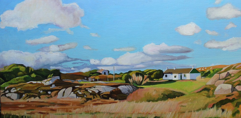
When I came to Donegal I was so blown away by the vast overarching skies and majestic landscapes. I got very excited by everything I saw. I tried to capture everything. The houses, the mountains, the sea, and the sky. Most of the time it worked.
Swirling Clouds Round Errigal
Donegal Painting
From Ferry Coll
From Cruit Island
Wild Wind Across Dunfanaghy
Shored up near Muckish
Further Up Shore
You can probably look through these paintings and tick off the composition approaches I instinctively used; the diagonal, the pyramid, the rule of thirds and so on. They all worked.
Then, it really pains me to admit it. I lost it. I got carried away and overreached myself and painted this big beast.
Sailing By Edernish
What was I thinking? There is far too much sky in this painting. Worse than that, it was a large canvas. There are things I like about the painting, the light on the island in the bottom half of the painting, but the sky was just too vast. It pained me that I had such a large reminder of my errors of judgment. I don’t mind screwing up every now and then but I hate waste and that was an expensive canvas. It’s no coincidence that I am planning a blog post on reusing stretcher bars to stretch my own canvases.
My confidence was dented. It put me off large paintings for quite some time. It wasn’t until I did the commission I mentioned earlier, that I got thinking about what had gone wrong. I realized that I had to rigorously apply the same rule of composition to large canvases as I instinctively did to my small ones. So I tried an experiment, I took a successful composition of a medium size painting and did a much larger version of it. This composition was based on a compound curve.
Over to the Rosses 60x40xmView From Arranmore, Ireland 92x73cm
It wasn’t a copy of the smaller painting. It wasn’t meant to be, although it was meant to encapsulate the same feel of the smaller work, with some adjustments. I have included some more detail, changed the tree, and added a shadow and a ditch in the bottom third of the painting. I think it worked.
I have since done another small oil sketch of another composition before I scale it up. It’s another diagonal composition. Although, the larger version will not be “portrait” format but my usual “landscape” orientation.
I will add the larger version later in the week. So you will have to wait to see if that composition works as well as this smaller one. Watch this space!
Autumn brings incredible colours to the west coast of Ireland. As the grass and bracken die off, they turn a fantastic shade of orange and pink. The pink granite rocks that litter the landscape accentuate the warm colours. They have provided me with much inspiration for my landscape paintings of Donegal, Ireland.
This series of paintings has been inspired by the Old Railway Walk which starts near Burtonport, near Dungloe in Donegal. There are no railways in Donegal anymore. There used to be. The line to Burtonport was built in 1903 as a joint venture by the British government and the Londonderry & Loch Swilly RailwayCompany to attempt to alleviate poverty in north West Donegal.
Steam trains at Burtonport, Donegal
The trains used to carry fish from the port at Burtonport in Donegal to Derry, in the neighboring county. It also carried many seasonal workers to and from Derry and Scotland. After 1922 the line crossed from one country into another; from the Irish Free State into Northern Ireland.
Railways in 1906: Credit: Donegal Daily.com Gweedore train station (Mount Errigal in the distance)
In the 1940s, however, the Irish government decided to close down the railways in Donegal. I have never really found a clear explanation for why this happened but I am going to assume that the cost of running the line was an important factor. There were also concerns about the safety of the line.
Owencarrow Viaduct, Donegal
In January 1925 disaster had occurred on the at theOwencarrow Viaductwhen winds of up to 120mph blew carriages of the train off the viaduct causing it to partially collapse. Four poor souls lost their lives.
Owencarrow Viaduct
After the Second World War, the Irish government presumably decided it would cost too much to continue the maintenance of the line and it was closed in 1947. The Burtonport-Gweedore section closed in 1940. There is a great graphic on the Donegal Daily hereillustrating the shrinkage and disappearance of the railways. Donegal became a very remote part of Ireland, with no railways and no (still) motorways. Communication with the area improved in 1986, however, whenDonegal airportstarted operations.
It seems that for half a century nothing much happened on the old railway line. In 2009, however, there was a heavy snowfall, and some of the old railway line was cleared to access water mains that needed repairing. The remaining section was later cleared and gradually developed as a walkway with the support of the local community. A massive effort has gone into creating this beautiful and peaceful walk.
The Burtonport Old Railway Walk
Here are some of my paintings inspired by my husband Seamas’s photographs of the railway walk.
There are many features of the old railway remaining which you can view along the way such as stations, gatehouses, accommodation crossings, lots of pillars, cuttings, embankments, a bridge and rusty gates. There are also lots of shelters for walkers to hide from passing showers to use.
dav
Photo credit: James (Seamas) Henry Johnston
Youtube video- Siúlóid an tSean Bhóthar Iarainn—The Old Railway Walk by Ralph Schulz.
Find out more about the Railway Walk by clicking on the links below:-
Getting here: From Letterkenny and Dungloe – SITI Rural Transport – Tel 0749741644. From Dublin – Bus Eireann@ www .buseireann .ie From Scotland & Northern lreland – Doherty Travel (00353) 749521867
I have been back in Wales for three days now and the big difference from Donegal is the temperature and light. It is much warmer in Wales. Last week I was wearing a jumper – here I am in a T-shirt. In Wales, last night it was very dark by 10 pm. In Donegal, however, the light seemed unending. I struggled to sleep, despite being very tired, because although the sunset was after 10pm, it didn’t seem to get properly dark until after well after 11pm. Then it started to get light pretty soon after 4am!
I would sometimes wake in the early hours and look at the dark as a novelty. That’s something I’ve never done in Wales. Yet, I got used to this abundance of light. I made me feel active. With no television to slump in front of, I would find myself doing things after tea, such as the evening I found myself sanding a table at 9pm. I got used to life without news on the radio, although I did listen to some podcasts I had downloaded before I left Wales.
The day we visited Arranmore Island was a sunny Saturday. No jumper, just a shirt. There are two ferry companies that operate from Burtonport Harbour, the Red, and the Blue. They run all year round. In the summer months, they put on extra sailings. We plan to catch the 12.30 ferry, which is the Red Ferry. That’s the favourite colour of Seamas, my husband’s, beloved football team, Liverpool, so he’s happy. The ferry is very busy. It’s delayed by 10 minutes as the last car fills the boat to capacity. There are lots of teenagers and families on board. We stand by the rails as all the seats are taken.
Arranmore Red Ferry and an Oystercatcher
The journey to Arranmore is always a treat. The ferry is speedy. It takes not much more than 15 minutes to complete the three-mile journey. I love looking at the islands (and their houses) that lie alongside the route.
Rutland Island is one of the largest of these and lies to the west. There are some very beautiful modern houses on Rutland, alongside ruins which date from the 18th century. These were part of the planned settlement built by William Burton Conyngham. He also owned Arranmore Island. In my painting “From Ferry Coll” (below) you can see the remains of the fish landing and processing complex on the left side of the painting. There was also once a post office, houses, and a school-house here.
From Ferry Coll (SOLD)
On the eastern side, lies the islands of Edernish, Inishchoo, and Eighter. Here there are old cottages tucked in amongst the rocks. There is sparkling sunshine, but once we leave the shelter of the islands, the sea becomes quite choppy.
On the Way to Arranmore (SOLD)
When we arrive at Arranmore harbour there are lots of friends and families waiting for the ferry. There is a lot of waving and photos taking whilst we wait for the cars to drive off the ferry. Then the people can get off the ferry. There are lots of hugs, laughter, and chatter as the passengers finally get off the ferry. It’s a delightful scene.
Arranmore is well worth visiting. It is the second-largest Irish island (the largest is Achill, in County Mayo, if you want to know). It is seven square miles in size and it is dominated by an imposing hill called Cnoc an Iolair (“Hill of the Eagle”, 750 feet) which can be seen from most of the coast of Gweedore ad the Rosses. It has both sandy beaches along the south coast (three of them) and imposing sea cliffs (120 meters) along the west and north side of the island. Many of the islanders are native Irish speakers.
Many islanders used to support themselves through fishing, wild salmon in particular, but in 2006 the EU banned salmon fishing. This has caused a great deal of hardship and anger. It has also meant that many of the young people have been forced to move away in search of work, so the population of the island is dwindling and aging. You can watch a beautiful short film, “A Foot of Turf” about island life here.
Fortunately, the island has recently undergone huge technological advancement and has become the recipient of Ireland’s very first offshore digital hub. In celebration they wrote an open letter to American and Australia, hoping to entice new businesses to the island. Sadly, the story went viral and got distorted in the process. British tabloids, in particular, decided to reframe the story as the island being desperate for immigrants, “begging US citizens to move there” and decided to be offended that they “forgot” to invite British people, writing headlines like: “Anyone but the English”. This caused a great deal of distress on the island as this wasn’t what was intended at all. The letter was meant to appeal to American businesses to help boost the economy by giving islanders jobs – and visit the island.
So we are visiting the island. First, we made our way eastwards, towards the lifeboat station. We then backtracked and walk up the road past The Glen Hotel, which was the island’s first hotel in 1928. It was once the home of John Stoupe Charley, a Protestant from Antrim, who bought the island in 1855.
View Above the Glen Hotel, Arranmore
It was a long hilly road with a beautiful view across to the mainland. There were many old cottages and outbuildings here. The road was generally quiet but we were periodically passed by several cars. I like to take note of where cars are from, in Ireland registration plates in include letters to denote the county of registration. There were many with “DL” Donegal plates, but also plenty with “D” Dublin and Northern Ireland plates. Although I’d seen plenty of German and Dutch vehicles driving along the Wild Atlantic Way (past our house) there were none on this stretch of Arranmore road.
Over to the Rosses (Donegal, Ireland) (SOLD)
It’s considered good manners in Donegal (and elsewhere, of course) for the driver and pedestrian to acknowledge each other when the car has to slow to pass and the pedestrian has to clamber into the grassy verge. In Donegal, the driver will lift the index finger of his right hand. The pedestrian will similarly lift his or her finger but not necessarily raising the hand to do so. Smiles will be exchanged too. Nothing to exuberant, but friendly. It’s rare that this doesn’t happen, sadly it does on occasion and then it is followed by a short discussion between Seamas and myself about the drivers of particular makes of cars and/or people from NI/Dublin/hirecars.
Me on Arranmore Island, Donegal
We get so far and decide to retrace our tracks and walk in a big loop along the west side of the island, which provides us with sweeping views across to Burtonport and Dungloe. If you look carefully in the photo below you will be able to see the old courthouse to the right. This was built at Fal an Ghabhann (Fallagowan) around 1855.
Old Courthouse, (Arranmore Island) SOLD
Eventually, the road wound downhill. We could hear the sound of singing on the wind. A choir singing? We eventually came to a large white Community Hall, the doors were open and inside were lots of young people singing in Irish. These were some of the hundreds of teenagers who come to the island as part of a summer scheme to learn and improve on their Irish language skills.
As if to reinforce this, a tall teenage boy passes us and greets us in Irish. Seamas manages a greeting but then tells me that the lad had used a different form of words to the one he’d learned over 30 years ago. It seems that the Irish language is very similar to the Welsh, in that it has many regional variations in terms of accent, pronunciation, and words used.
House By The Red Wildflowers (SOLD)
We finally made it back to the harbour and had two delicious cheese paninis in the sandwich shop.
Here comes the Blue Ferry!
The journey back to Burtonport harbour on the Red ferry was very enjoyable, with the passengers still in a buoyant holiday mood, waving at the passengers on the Blue ferry as we passed. A holiday maker’s car alarm kept going off. His embarrassment levels pretty much matched that of his children’s amusement.
I kept a lookout for dolphins or seals but saw none. Only sea birds. An American told me that he’s seen Minke Whales in Clew Bay recently. We had seen dolphin on the way back from Tory island. He had a theory that there was a bumper crop of fish 8 miles out at sea, which was where the wildlife were. Usually, the waters around Burtonport would have plenty of seals and dolphins. That’s something to look forward to seeing another time.
For more on Arranmore and other Donegal islands in general doub;e click on the link
I am very delighted to say that we returned from Donegal to the news that you can now buy my work as framed prints at John Lewis! If you are not familiar with John Lewis, they are a British “high end” department store, who also run the Waitrose supermarkets. They have stores in the Republic of Ireland and Australia.
These two images are available from John Lewis stores throughout the UK “Drifting Clouds” and “Great Tor From Tor Bay”.
Drifting Clouds Over Three CliffsGreat Tor from Tor Bay
I am delighted to have sold “Koei 1509”, a painting of a South African cow, to a collector in Oxfordshire, England. The painting was based on a photograph by talented photographer Herman von Bon, who generously allowed me to use his image. Herman photographs the South African landscape along with its people and animals. I particular like his wildlife photography.
Koei 1509
I like cows. I love all animals. I come from a family of animal lovers. I get pleasure from just looking at animals. I really enjoy painting them but I find it hard to part with my animal paintings.
Cows are the reason why I stopped eating meat a long time ago. When I was a post-graduate student at Cardiff University in the 1990s I spent a day cycling along the the flat marsh road that lies between Cardiff and Newport. It’s about 10 miles. On my way back, I stopped at a gate for a rest. I group of curious youngsters, Fresians, came up to gate to investigate me. They were cautious but seemed to egg each other on to come closer and stick out their noses to me. They amused me. I thought they were funny and sweet.
I stood for quite a while looking at them. Listening to them breathe. Cows have intelligent eyes. Big brown eyes. They weren’t essentially any different from the many animals my family had kept as pets over the years; cats, dogs and rabbits. Suddenly the thought came to me “I eat you and your friends”. I felt awful. Very guilty.
It felt very unnecessary. I don’t need to eat meat. So I decided to stop. I’d been thinking about for for some time. People sometimes ask why I am a vegetarian and I could mention things such as the cruelty of factory farming, the environmental cost but I have never felt comfortable eating sentient creatures. I always felt a hypocrite for eating Sunday roast, no matter how tasty it was.
Hereford Red (Sold)
Many of my university friends were veggies but I didn’t like many vegetables (potatoes and peas was about it for many years) and I wasn’t sure what I would eat. To be honest, I was lazy. I had to learn to cook vegetarian meals. I started with a lot of pesto and pasta. A friend of mine recommended a Rose Elliot cook book and I painstakingly read the recipes (there were no photos in the book) and I eventually learnt a few recipes off by heart. It was a bit of a slog but I felt much better for it, physically and mentally.
Although I don’t think that I paint cows all that often, they have added up over the years. I love Hereford cattle in particular. I was born in that English county and I love the russet red of their coats. You don’t see that many of them on Gower.
Punk Cow (SOLD)
I seems to have painted Frisians the most – probably because I like the contrast of their black and white coats.
Gower Cow (SOLD)
Gower Cow
I never paint “generic” cows. These are all real cows. All individuals. I found Gower Cow on the slopes of Cefn Bryn at the Penmaen end. She was chewing the cud with a small group of friends.
Grazing at Pwll Du
The cow at Pwll Du was also with a group of friends, small herd I suppose, who came out of the undergrowth and started grazing on the grass by the stream at Pwll Du.
Lady Muck
Writing this post got me thinking about the History of the cow in Art. There’s a lot to it so I have decided to save that for my next post.
I was feeling very nervous about this walk as I would have to change buses in the middle of nowhere. I very nearly chickened and got in my car after a fellow blogger commented that I “should not bother with rural buses but drive. However, it was a long walk, just over six miles, and I did not want to break it up into two or three circular walks. I wanted to walk the length of the north Gower coast in one go, if I could. So I got up and packed sandwiches, lots of biscuits, a banana in its strange yellow banana “gimp” case and two bottles of water. I had decided that thirst was the worst torment on my last two solo trips and I was going to be better prepared this time.
North Gower Coast
I had caught the same bus to Port Eynon (the number 119 to Rhossili, if you interested) and had changed at Scurlage but this time I had to change at a location called Llanridian Turn. I have studied the map and I think I know where it is. I don’t remember passing it from the previous bus journey and it doesn’t really seem to be “on the way” to Rhossili. So I check with the bus driver as I buy my ticket.
Buses at Llanrhidian Turn
The bus arrives at Llanridian Turn and it pulls in behind another bus, a number 116, but its not the one I want. So I ask the driver about the 115 to Llanmadoc and he says that he’s driving it and walk towards a small bus that has just arrived and he swaps buses with the new driver. He’s a friendly chap, with a sparkly diamante earring in one of his ears. So we set off. I am the only passenger.
St Madoc’s, Llanmadoc
I end up standing at the front of the bus (holding on to the special rail) chatting to the driver for most of the journey. “You couldn’t ask for better weather” he says. He’s right. It’s a sparkling bright spring morning. It’s cold though. Only 7 degrees Centigrade (that’s 44 in Fahrenheit). He fishes out a timetable for me from his rucksack. It’s a timetable that covers all Gower buses. I have not seen this before, it certainly wasn’t to be found in the bus station anyway. “Where do you want to get off?” I have never had a bus driver ask where I want to stop before. This must be one the joys of rural bus services. I eventually get off by Llanmadoc Post Office. I wave at the bus driver as he drives away as if we are old friends.
I find a path, not an official coastal one, but it is sign posted for Whiteford Burrows, which seems the right direction, so I take it. It’s more of a farmers’ track than a path. I walk down a long muddy track, pass cattle, sheep and an old tractor and eventually reach the same point as we did on our detour from Cwm Ivy (to avoid the breached sea wall). I find it more by luck than any thing. It is very muddy.
This is Landimore Marsh. It’s a saltmarsh, an area of coastal grassland that is regularly flooded by seawater. Springs, small rivers called “pills”, flow out into the estuary, in meandering lines that make maze-patterns in the marsh. The main pills crisscrossing the area are Burry Pill and Great Pill.
Pill House, Llanmadoc
For hundreds of years, the people who lived along its edge have used the marshlands for grazing their animals. They still do today. The lambs that are raised on the salt marshes are reputed to have a distinctive and special flavour, but I cannot speak from experience as I am a vegetarian. Although the cows and ponies know to move off the marsh with the advancing tides, especially the spring tide that can move with great speed, the sheep for some reason don’t. The local farmers have to bring them in. Although sheep can swim, as all animals can, for a short period of time, if they get cut off by the tide they will drown.
The walk along the marsh path is very muddy indeed. I have visions of me sliding and twisting my ankle or falling flat on my face, but I manage to survive without incident. I take the low tide route, but I spent much of my times sliding around wondering if the high tide route would have been less muddy.
To my right is North Hill Tor, or Nortle Tor, on which are the remains of a partial fortifications, probably dating back to the Iron Age period (c. 800 BC – AD 43). According the the famous Swansea-born historian, Wynford Vaughan Thomas, Nortle Tor was quarried in previous centuries. During the Napoleonic Wars, one of its extensive caves provided useful hiding place for local young men when the press gang was spotted coming across the estuary from Llanelli.
North Hill Tor, GowerLandimore Marsh, Gower
There is a wonderful presence about the marsh. It stretches away as flat as a proverbial pancake. No sea, or River Loughor in sight. The marsh is indented by patterns of muddy pools, creeks and channels. It is very peaceful and I get drawn into the atmosphere of the marsh. The grass has a curious white-ish tinge to it which I assume is from the salt. I see a lot of sheep’s footprints but no sheep, although I can see a few ponies far away on the marsh. It turns out that the sheep are in the farmers’ fields with their lambs.
The path eventually passes a couple of houses and leaves the marsh. I see my first fellow walkers of the day. I only see one other couple on the path today. I see, however, vast numbers of sheep and lambs, marsh ponies, robins, sparrows, a red kite and a large Great White Egret flying over the marsh.
The path reaches Bovehill, where it turns further inland and passes the remains of another fortification, Bovehill Castle, a fortified mansion with walls a metre thick. It was once the seat of the 14th century crusader knight, Sir Hugh Jonys and later Sir Rhys ap Thomas, a support of Henry Tudor (the father of Henry VIII of six wives fame).
Phone Box at Landimore
Ivy Cottage Landimore
The “coastal” path then turns off the road onto Bovehill Farm. I can’t see the sea and now I can’t really see the marsh, either. I don’t see the marsh again for a long time, perhaps for about as much as an hour as the path trails inland. In fact, it turns out its about 2 and a half miles to Llanridian. The path instead, runs through the farmland, parallel to the marsh.
This get a bit confusing. I often enter a field and have little idea of where the path goes. So I set off at a 60 degree angle only to adjust my course when I eventually spot the stile in the opposite corner of the field.
Where is the path?
There have not been enough walkers recently to make tracks for me to follow across the fields.
Landimore, North Gower
I see swallows (the first I have seen this year) over the fields by Landimore. Weobley Castle, another fortified manor house, is a dark presence looming on the cliff above me. From the time of the Norman conquest of Gower to the 15th century, Weobley belonged to the de la Bere family.
Weobley Castle, above the path
Just below Weobley Castle there is a road that leads out into the marsh.
The salt marsh by Weobley Castle
Where does it go? It doesn’t seem to go anywhere, as such.
Marsh Road by Weobley Castle, North Gower
At the end of the track, there is a odd wooden structure out in the estuary. I can see it with my naked eye but my camera is struggling to get a good picture. I think its made of wood. I can’t tell. You can see it from miles around.
What is it? Is it a wooden structure in Burry Estuary, Gower?What is it?
According to historian Wynford Vaughan Thomas, the American army used the marshes as a firing range during the Second World “War. It turns out that it was the US army that built the causeway out into the marshes. The strange building, is not wooden but made of concrete and brick. It was a look-out built by the Americans. I have to search online for close up photographs.
Photo credit: mylifeoutside.co.uk
There is a very dark tale about the Burry Estuary during the Second World War that Wynford was probably not aware of, as it was kept secret until 1999. There had been rumours about the secret testing of chemical and biological weapons in the estuary during World War II for many years. This story is to do with the British government and experiments in biological warfare, not the American Army. The wartime government had asked Porton Down, its chemical warfare research installation, to conduct trials of an anthrax bomb. Anthrax, is a lethal bacteria, which was seen as having “enormous potential” for biological warfare. I would like to point out that biological warfare was, and still is, banned under a 1925 Geneva protocol. This is why countries will make a big fuss about its use on civilians in Syria or even Salisbury, England.
Bristol Blenheim
In 1941 there had been a series of tests of anthrax bombs on the uninhabited Gruinard Island, off the west coast of Scotland. These tests had produced contradictory results, primarily due to the soft, boggy ground at Gruinard, so it was decided at short notice to carry out a single replacement test on the firm sand of the Burry Inlet.
On a Wednesday afternoon, in late October 1942, the scientists carried out an experiment over the north Gower salt marshes, dropping an anthrax bomb from a Blenheim aircraft. Two lines of 30 sheep were placed downwind of the aiming mark, spread at 10 yard intervals. When the bomb fell it made a crater of about three feet in width and two feet deep. Three days after the trial, two of the sheep died of anthrax septicaemia, and three others were ill for a day or so before recovering entirely. Apparently, the scientists proclaimed the test result ‘very satisfactory’, especially as this was the first time such a bomb had been dropped from a plane flying at operational level.
Warning sign on the marshes
According to the report, the site was ‘effectively decontaminated’ by the incoming tide a few hours after the test took place. The carcases of the dead sheep were ‘buried deeply at the seaward edge of the marshland area’. The remaining sheep were observed for seven days after the test, the survivors then being slaughtered and buried.
This all seems a bit of a casual clean up and in marked contrast to the situation at Gruinard island, which had served as the previous test site for anthrax. In that case the entire island was set ablaze and subsequently closed to public access for nearly 50 years. Even today people and animals alike avoid the island, despite efforts to decontaminate the island in the 1980s. All I can assume is that larger quantities of anthrax was used in Scotland.
Update: There’s no need to worry about the dangers of anthrax as it was confirmed in 1987 that “investigations …[after the] trial revealed no evidence of any residual contamination”.
Gruinard Island
When the path finally reaches Llanrhidian, it seems like quite a shock after all the open space of the marsh and the fields. I think about walking up to the main road where I could catch a bus home but instead I press on .
My next post will be my final stage of the coastal path, from Llanrhidian along the coastal road to the village of Crofty.