Donegal has lots of breathtaking scenery. I love the coast and the old white houses and a lot of my recent paintings have been concerned with depicting a more intimate impression of Donegal. I don’t like to get into a rut, and I will switch subject matter to challenge myself and keep my work “fresh”.
Painting mountains is one way of doing that for me. I have painted three pictures of the Derryveagh mountains since October 2018. They are based on a series of photographs we took on a trip to Horn Head. For an excellent interactive map of the area click here
Horn Head, Donegal
I had been worried about driving along precipitous cliff tops and we had parked up and walked up to Horn Head. The view was great but the overcast conditions did not make for particularly good photographs. We climbed up part of the spongey hill. I call it spongey because every time I put my put on something that wasn’t a rock, it sort of sank into the heather or boggy grass. It was very unsettling. So I leap from rock to rock. From here we took in the strong breeze and could see across to Dunfanghy.
There were also sweeping views across back towards Falcaragh and Bloody Foreland (Cnoc Fola in Irish). What a great name that is, it refers to the colour of the headland, not to some gruesome incident of the past. The light was in the “wrong” direction for decent photos but the view was lovely.
On the way back down to Dunfanaghy, the sun broke through the clouds off in the distance, we stopped and Seamas took some pictures. These are the photos the three paintings are based on.
These paintings are quite a commitment, in terms of effort and resources as they are physically large (for me, anyway) and mentally demanding. I usually like to paint bright and quite detailed landscapes. These paintings, in contrast, were an exercise in subtly and knowing when and where to include more or less details.
Across to Dunfanaghy SOLD
With all of them, I begin with the sky and work my way down the canvas. As with a lot of my work, I use the paint quite thinly and I find this helps keep the clouds feeling “light”. They are just layers of water vapor, after all. The linen canvas I use is primed with a clear primer so it is brown rather than white in colour. I find this brown works well as a base for dirty looking rain clouds!
My first two paintings I initially painted the distant mountains a range of graduating purples until I stood back and realised that they had to be lightened a lot. I spent a lot of time holding up my paint covered brush next to my reference photograph to compare the shades. I learned that the mountains had a lot of warm grey in them.
Wild Wind Over Dunfanaghy SOLD
The greens of the mid area and the foreground were much easier to gauge although I still visually checked that my tones were correct by holding the paint next to the reference image. The many walls and varying tones of the fields required a great deal of concentration. This was the most detailed part of the painting. I wanted the viewer to look into the distance rather than be distracted by detailed grass in the foreground. So the grass in the foreground is quite flat with only the odd change in colour to hint at roughness.
By the time I had painted the third, most recent, painting in the series, I had learned from experience to keep the colour of the mountains light. The falling rain over the far mountain meant that most of the tones of the grass and bogland were much more muted than in the earlier paintings. There was a lot of greys and purples in the grass and gorse.
Each of the three paintings, although they are of a similar view, each has quite a different feel to it. They remind me how on some days you can stand and watch the light and colours change second by second in Donegal as the clouds move and showers sweep in from the west. The last one does that the most. I think my next challenge will be to paint a mountain scene without any houses at all, just sky and mountain and resist the urge to add detail!
The title of this post comes from a 2005 albumby American musician, Robert Rich.
The inspiration for this album comes from mundane everyday experiences that culture usually overlooks, such as footsteps, casual voices and other ordinary sounds. Although I am sort of “New Wave” (that’s sooo old now, you’ll probably have to look it up) in my musical tastes, I have a sneaky liking for experimental music, if its “live”. I like how it encourages you to pay attention to all the sounds around you, instead of tuning them out with your thoughts. Its sort of mediative. The ordinary appeals to me.
The other day I finished one of my paintings, placed on the other side of my studio to inspect and found myself quite-spell bound by it. I could not stop starring at it. This is not always the way I am with my finished work. More often when I have been excited about a painting, finishing it is a bit of an anti-climax. Maybe, it wasn’t quite what I thought it was going to be. All I can see are the errors. The solutions that weren’t quite right, or not as good as they could have been.
So what was this painting that had me transfixed? You’ll probably laugh when you see it. It was a little painting of two blue tits on a branch. Not a spectacular painting, in any sense, I know. I realised, however, that what had me transfixed were the details. This is really geeky stuff. A shadow under one of the bluetits fell onto the branch below in a really pleasing way. It’s hard to show it here.
Two Blue Tits (detail)Two Bluetits
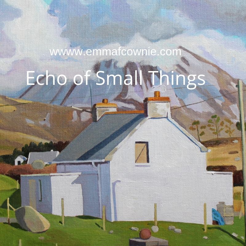
This is my most recent painting below. I choose to paint this because I liked the juxtaposition of the mountain behind the semi-derelict house.
Near Dunmore Strand
I didn’t realise at first that the gable end window is boarded up. It could be mistaken for a blind. Maybe it is a roller-blind pulled down.
Detail (work in progress)
I think the back door is also boarded up. These things are not immediately apparent. There is a large boulder to the left of the house. There is also a pile of building bricks and a tarpaulin in the yard to the right-hand side and old rope in the drive. This is a house at the start or midway through renovations. The details I really relished painting were the shadows of the chimney, roof and the telegraph wire that dissects the window at neat diagonal. It’s only by paying attention to these details that the Donegal light can be properly conveyed.
I have always had a fascination for the ordinary details that are easily overlooked. I want to convey what a scene looked like at that moment. If you were really paying attention. Yet, I am not a painter who works in the hyper-realist style. I am not skillful or patient enough for that. I often cringe when I see my paintings close up because I think some of my brushwork is crude. Yet, “perfect” representation can seem dead and unlife-like.
I think in the errors, the gaps, our brains fill in the gaps the image can come alive. I like that my paintings aren’t just copies of what I can see but an interpretation; the colours brightened, edges sharpened or softened, some details omitted to make for a simpler composition. Deciding what to leave out or simplify is as important as what you decide to include. Rather like Robert Rich’s “Echo of Small things”
Gola is a Donegal island I painted and thought about long before I set foot on its shores. I have written about it beforehere.Last month I was fortunate to visit it. The wind had woken me in the night. The early dawn had me awake by 6.30. I felt so tired and my limbs ached that I drank the last can of caffeinated energy drink that was sitting in our fridge (leftover from the epic drive up north).
We drove the 40-minute drive from Burtonport to the little harbour at from Magheragallon Pier, Bunbeg. The final part of our drive was along single-track road across flat grasslands which were home to both a graveyard and a golf course. That sounds grim but there’s plenty of space for both here.
View of Gweedore from Magheragallon (Machaire Gathlán)
It was the most perfect of days. The sun was shining, the sea was sparkling and flat and the sky was a hazy light blue. The sand was very light, but not white. The sea was incredibly clear and on a clear day like this, you could easily see the seabed, giving the sea a beautiful turquoise colour.
“The Cricket” at Magheragallon Pier (Machaire Gathlán)
The pier is well set up for waiting travelers with benches and a portaloo. We sat on a bench and waited for Sabba the boatman to give to signal to get on board. Seamas, my husband, tells me that Sabba the boatman has been sailing since aged 7. He has a facebook page herewhere he will post times of sailings and photos.
Fisherman off Gola
It’s only a 15 minutes crossing. As soon as we set foot on the island, I am struck by the sense of peace here. Most of the sounds you are of nature. Birds singing. Sheep bleating. The wind. That’s it.
Gola Pier
This is because there are very few motor vehicles here, one or two cars and some tractors.
A fine red tractor
Gola is in the Donegal Gaeltacht, where many people speak Irish. They are brought up speaking Irish at home and in school. So the signs are in Irish. Some have English translations, but not all did.
In 1911 as many as 169 people lived here but in the 1960s people started leaving as jobs and a better standard of living on the mainland and abroad had a stronger appeal than full-time life on the island. Only a handful of people live here all year round now.
Gola is part of the Gaeltacht
It’s so peaceful. The land is covered vast stretches of long yellow prairie-like grass spotted with rocks and a few sheep and their sturdy lambs. The houses are scattered across the island along tracks.
Boat for Sale on Gola
Some of the houses are modern, others have been renovated and are still lived in during the summer months at least, others are boarded up but many lie ruined, without roofs or reduced to crumbling walls.
Houses on GolaHouses on Gola
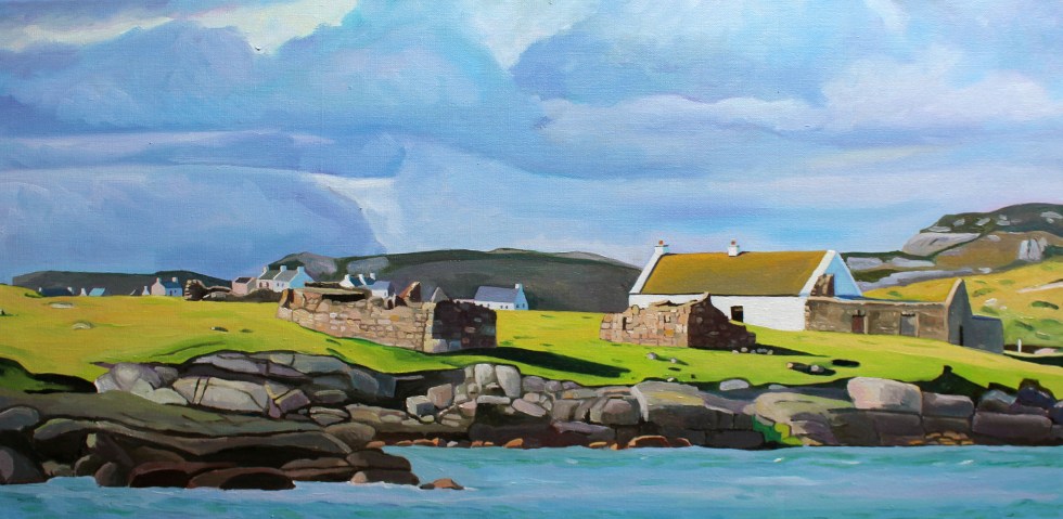
It was interesting to see the houses on Gola close up after looking across the water at them from Dunmore strand (see painting below). The houses are spaced much further apart than I supposed them to be. I was not satisfied until I had walked all the way to the southern tip of the island, so I could turn and look back at the houses. In this way, I could make sense of what I saw in early spring.
Spring Light on Gola
The houses are close but not that close. All of their front doors face southwards, towards the mainland. Mount Errigal and Muckish are off in the distance. I didn’t realise that you could see Muckish this far south. I suppose I have had never been here on such a clear day before.
Gola – View Towards the South West
I tried to take a photo of two camera-shy woolly donkeys in a field. They took exception to my presence and brayed very loudly at me. I got the message and left them in peace. Even the sheep eye you up, they are not used to strangers. They seem to look at you as if they are saying “You are not our farmer, what are you doing here?”.
Donkeys on Gola – No photos please!Port an ChruinnCottage to Let
Houses facing the mainland
On they way back to the boat we pass the infomation centre – an Teach Beag – its a large shed with tables outside. We are hot and I fancy a cup of tea. I try out the one bit of Irish I know on the man behind the counter “Dia duit” (“Hello”) I say. He then says something back to me which I dont understand. That stumps me. Turns out that he just said “Hello” back to me (“Dia is Muire duit”). I need to get a few more phrases/word in Irish under my belt!
This is Paddy Joe, who is 73 years old and still volunteers for the local lifeboat (training and teaching younger volunteers). It is noticeable how fit and active people in Donegal are, especially the men. We talk in English. I love listening to his accent, Irish is his first language. It’s musical. Part Ulster accent, part something else, something almost Scandinavian. Certainly, of the north. It sort of reminds me of the halting accents of Welsh-speaking farmers in North-Wales, as they seem to trip over their words as they think the right word in English.
Paddy Joe tells a story of going fishing down the Kerry coast and stopping in a pub for a drink. There are Irish speakers there but they do not understand the Irish speakers from Donegal, and the Donegal Irish speakers do not understand them either! I know that its similar in Wales, where Welsh speakers from the North use many different words from those in the West or South.
Some of the few trees on Gola
We decide to catch the 2 o’clock boat back as we have eaten all our sandwiches and the next boat is at 6pm. There is plenty more island to explore on another visit. We haven’t seen the sea arch at Scoilt Ui Dhúgáin, the lake Loch Mhachaire n nGall.
Clear Seas off Gola (Bloody Foreland in the distance)
The boat is setting off, when Sabba spots two girls who came across with us at 11am. He returns to shore to pick them up. They get on the boat looking very relieved. They clearly didn’t fancy waiting until 6pm for the last boat back. The sky is starting to cloud over as we cross and by the time we reach Magheragallon Pier it is overcast.
I have been back in Wales for three days now and the big difference from Donegal is the temperature and light. It is much warmer in Wales. Last week I was wearing a jumper – here I am in a T-shirt. In Wales, last night it was very dark by 10 pm. In Donegal, however, the light seemed unending. I struggled to sleep, despite being very tired, because although the sunset was after 10pm, it didn’t seem to get properly dark until after well after 11pm. Then it started to get light pretty soon after 4am!
I would sometimes wake in the early hours and look at the dark as a novelty. That’s something I’ve never done in Wales. Yet, I got used to this abundance of light. I made me feel active. With no television to slump in front of, I would find myself doing things after tea, such as the evening I found myself sanding a table at 9pm. I got used to life without news on the radio, although I did listen to some podcasts I had downloaded before I left Wales.
The day we visited Arranmore Island was a sunny Saturday. No jumper, just a shirt. There are two ferry companies that operate from Burtonport Harbour, the Red, and the Blue. They run all year round. In the summer months, they put on extra sailings. We plan to catch the 12.30 ferry, which is the Red Ferry. That’s the favourite colour of Seamas, my husband’s, beloved football team, Liverpool, so he’s happy. The ferry is very busy. It’s delayed by 10 minutes as the last car fills the boat to capacity. There are lots of teenagers and families on board. We stand by the rails as all the seats are taken.
Arranmore Red Ferry and an Oystercatcher
The journey to Arranmore is always a treat. The ferry is speedy. It takes not much more than 15 minutes to complete the three-mile journey. I love looking at the islands (and their houses) that lie alongside the route.
Rutland Island is one of the largest of these and lies to the west. There are some very beautiful modern houses on Rutland, alongside ruins which date from the 18th century. These were part of the planned settlement built by William Burton Conyngham. He also owned Arranmore Island. In my painting “From Ferry Coll” (below) you can see the remains of the fish landing and processing complex on the left side of the painting. There was also once a post office, houses, and a school-house here.
From Ferry Coll (SOLD)
On the eastern side, lies the islands of Edernish, Inishchoo, and Eighter. Here there are old cottages tucked in amongst the rocks. There is sparkling sunshine, but once we leave the shelter of the islands, the sea becomes quite choppy.
On the Way to Arranmore (SOLD)
When we arrive at Arranmore harbour there are lots of friends and families waiting for the ferry. There is a lot of waving and photos taking whilst we wait for the cars to drive off the ferry. Then the people can get off the ferry. There are lots of hugs, laughter, and chatter as the passengers finally get off the ferry. It’s a delightful scene.
Arranmore is well worth visiting. It is the second-largest Irish island (the largest is Achill, in County Mayo, if you want to know). It is seven square miles in size and it is dominated by an imposing hill called Cnoc an Iolair (“Hill of the Eagle”, 750 feet) which can be seen from most of the coast of Gweedore ad the Rosses. It has both sandy beaches along the south coast (three of them) and imposing sea cliffs (120 meters) along the west and north side of the island. Many of the islanders are native Irish speakers.
Many islanders used to support themselves through fishing, wild salmon in particular, but in 2006 the EU banned salmon fishing. This has caused a great deal of hardship and anger. It has also meant that many of the young people have been forced to move away in search of work, so the population of the island is dwindling and aging. You can watch a beautiful short film, “A Foot of Turf” about island life here.
Fortunately, the island has recently undergone huge technological advancement and has become the recipient of Ireland’s very first offshore digital hub. In celebration they wrote an open letter to American and Australia, hoping to entice new businesses to the island. Sadly, the story went viral and got distorted in the process. British tabloids, in particular, decided to reframe the story as the island being desperate for immigrants, “begging US citizens to move there” and decided to be offended that they “forgot” to invite British people, writing headlines like: “Anyone but the English”. This caused a great deal of distress on the island as this wasn’t what was intended at all. The letter was meant to appeal to American businesses to help boost the economy by giving islanders jobs – and visit the island.
So we are visiting the island. First, we made our way eastwards, towards the lifeboat station. We then backtracked and walk up the road past The Glen Hotel, which was the island’s first hotel in 1928. It was once the home of John Stoupe Charley, a Protestant from Antrim, who bought the island in 1855.
View Above the Glen Hotel, Arranmore
It was a long hilly road with a beautiful view across to the mainland. There were many old cottages and outbuildings here. The road was generally quiet but we were periodically passed by several cars. I like to take note of where cars are from, in Ireland registration plates in include letters to denote the county of registration. There were many with “DL” Donegal plates, but also plenty with “D” Dublin and Northern Ireland plates. Although I’d seen plenty of German and Dutch vehicles driving along the Wild Atlantic Way (past our house) there were none on this stretch of Arranmore road.
Over to the Rosses (Donegal, Ireland) (SOLD)
It’s considered good manners in Donegal (and elsewhere, of course) for the driver and pedestrian to acknowledge each other when the car has to slow to pass and the pedestrian has to clamber into the grassy verge. In Donegal, the driver will lift the index finger of his right hand. The pedestrian will similarly lift his or her finger but not necessarily raising the hand to do so. Smiles will be exchanged too. Nothing to exuberant, but friendly. It’s rare that this doesn’t happen, sadly it does on occasion and then it is followed by a short discussion between Seamas and myself about the drivers of particular makes of cars and/or people from NI/Dublin/hirecars.
Me on Arranmore Island, Donegal
We get so far and decide to retrace our tracks and walk in a big loop along the west side of the island, which provides us with sweeping views across to Burtonport and Dungloe. If you look carefully in the photo below you will be able to see the old courthouse to the right. This was built at Fal an Ghabhann (Fallagowan) around 1855.
Old Courthouse, (Arranmore Island) SOLD
Eventually, the road wound downhill. We could hear the sound of singing on the wind. A choir singing? We eventually came to a large white Community Hall, the doors were open and inside were lots of young people singing in Irish. These were some of the hundreds of teenagers who come to the island as part of a summer scheme to learn and improve on their Irish language skills.
As if to reinforce this, a tall teenage boy passes us and greets us in Irish. Seamas manages a greeting but then tells me that the lad had used a different form of words to the one he’d learned over 30 years ago. It seems that the Irish language is very similar to the Welsh, in that it has many regional variations in terms of accent, pronunciation, and words used.
House By The Red Wildflowers (SOLD)
We finally made it back to the harbour and had two delicious cheese paninis in the sandwich shop.
Here comes the Blue Ferry!
The journey back to Burtonport harbour on the Red ferry was very enjoyable, with the passengers still in a buoyant holiday mood, waving at the passengers on the Blue ferry as we passed. A holiday maker’s car alarm kept going off. His embarrassment levels pretty much matched that of his children’s amusement.
I kept a lookout for dolphins or seals but saw none. Only sea birds. An American told me that he’s seen Minke Whales in Clew Bay recently. We had seen dolphin on the way back from Tory island. He had a theory that there was a bumper crop of fish 8 miles out at sea, which was where the wildlife were. Usually, the waters around Burtonport would have plenty of seals and dolphins. That’s something to look forward to seeing another time.
For more on Arranmore and other Donegal islands in general doub;e click on the link
I have been ill this week so this is a short post.
In last week’s post, Seamas, my husband and I were standing on rocks looking out towards Gola island in Donegal. This week we are looking back inland to Dunmore Strand, and beyond to Mount Errigal.
Dunmore Strand (with Mount Errigal in the distance)
As soon as I saw this scene I knew I wanted to paint it. I loved the dark shadow under the protruding lip of the undulating dunes. It gave the impression that the grasses were merely a thick blanket laid across the top of the sand.
Scattered along the beach and in the water, were granite rocks. These were so large that they were more like massive boulders. They were a beautiful pinkish colour close up. The sand was also very slightly pinkish but closer to the shoreline it was almost white. Lines of seaweed marked the rising and falling tide.
The tiny white houses gave a sense of sense scale of the dunes. They reminded me a little of boats on the surface of a heaving sea; humans eeking out an existence on the edge of nature. The ocean itself was calm and benign. It was as clear as glass at the shoreline and further out was a beautiful turquoise. It is not always this smooth creature, in autumn, I have seen it roaring and thrashing the shoreline like a wild beast.
Mount Errigal dominates this part of West Donegal, known as Gweedore. The mountain looks close but it’s an optical illusion, it’s actually about 10 miles away to the east. The top of Mount Errigal was swathed in clouds. The mountain always seems to have clouds around its shoulders, or totally smothering it. I had to wait for about 3/4 of an hour for the mists to part for a clear view of the peak. The clouds near to me were dirtier rain-filled clouds that were building and threatening to release their burden on the land somewhere nearby.
Another wonderful thing about this beautiful beach is that on this chilly April afternoon is that there was not another soul there. The only people we saw were the postman in his van on the way down the long lane to the beach.
My next post will peer “through a glass darkly” at Seamas’s Donegal family history (it is very dark in places) and the History of Gweedore along with the controversial issue of modernizing landlords.
My husband, Seamas, loves islands. He’s not alone, many people dream of living on or even owning their own private island. I just love looking at them and painting them. Which is handy, as the coastline of West Donegal is completely smothered with them. Looking out from the coast of Donegal, one of the longest in the country at more than 800 miles, is a bit like looking at the night sky and trying to name as many of the brightest stars as you can. Seamas seems to know most of their names without having to look at a map.
The larger Islands of the Coast of West Donegal
Around the coastline of the island of Ireland, there are 365 small islands, and a good number of those lie off the coast of Donegal. Wikipedia has individual pages for 20 of them, but there are many more than that. I can’t find an exact number. Many islands near the coast are little more than rocks big enough for some seaweed to cling to the edges of, visible only at low tide. Maybe these are just baby islands, islets. How big does a piece of land surrounded by water have to be to be an island, I wonder? If it’s big enough for some grass and a cow it must definitely be an island. There are quite a lot of those near Burtonport. The cows are well known for swimming between the island in search of better grass. I kid you not, it’s common off the coast of Inishcoo – click here for more evidence. I think the association between cows and island grazing is an ancient one as several islands take their names from cows, such as inishbofin (Inis Bó Finne) means island of the white cow and Calf island near Aran Island.
There are also about 100 sea stacks. Are these thin, vertical towers of rocks jutting out of the sea proper islands, I wonder? Slighter bigger and desolate are The Stags, or Stag Rocks, also known as The Three Sons of O’Gorra (Na Trí Mic Ó gCorra) which lie someway to the north of Owey island. Legend says that they were three pagan swimmers who were turned to stone by St. Colmcille the 6th Century missionary, also known as Columba.
The Stags
Then there are islands that have (or used to have) people living on them. Arranmore is pretty big (8 square miles) and is home to a sizeable community of about 500 people full-time residents. Some islands are easy to get to, such as Cruit, which has road bridge to the mainland, and Arranmore and Tory which have a daily ferry. There are others that have only summer ferry such as Gola and Owey Islands.
There are a lot of islands with no ferry but can be reached relatively easily by boat or kayak such as Inishsirrer, Inishmeane, Edernish, Rutland, Eighter, Inishillintry, Inishinny, and Bo, Go and Allagh, Inishmeane, Inishdooey, Insihbeg, Inishfree Lower but are close-ish to the mainland, and others that are pretty remote, even to people with their own boats such as Umfin, Tororragaun and Raithlin O’Birne and then finally there are the very remote ones are Stags Rocks mentioned above and Roan Inish. Some like Arranmore and Tory are inhabited all year round, others like Owey and Gola are mostly home to people during the summer months.
From Cruit Island
I love the descriptive names of the islands thus Cruit (An Chruit) means harp-shaped, Owey (Uaigh) means cave as there’s one under the island, Island Roy (Oileán Ruaidh) means Red Island, Inisheeney (Inis éanaigh), bird island and Tory Island, (Toraigh) means High Tower and when you see photos of the island you understand why that is a good description of the island.
Tory Island from the mainland
I have driven across the little bridge to long Cruit Island and I have boldly reversed my car onto the ferry to Arranmore and back again. I have spent a fair bit of time standing on the shore looking across the water at islands, Owey is a good example of this.
Owey IslandOver to Owey
My latest subject for this mainland-based island-gazing is Gola. Its name sounds vaguely sporting, forever muddled in my mind with football and trainers probably because I used to have a pair of Gola gazelle trainers back in the 1990s. The island has nothing to do with trainers or goals. The name Gola, or Gabhla in Irish, means “forked”. If you look at a map of the island the name makes sense. The fork is the split in the west face of the island.
Map of Gola Island
We set off on a sparkling afternoon in early April. The sun is out but it’s cold, with a chilly wind. I’d wear my big wooly hat in the car but the bobble on top is too big and it hits the headlining. So I drive without it on. In order to get to a good look at Gola, we drove past Donegal’s tiny airport at Carrickfinn, along a long single track road. There’s a lovely view of Mount Errigal off in the distance.
Errigal from Carrickfinn
The track then rises and winds its way past a series of isolated houses, both and old and modern. The road is a bit threadbare in places, in good condition in others.
We follow the road until we reach a fine modern house overlooking what I’d call a beach, but this sort of long stretch of curving sand is known as a strand in Ireland. I think this is Dunmore Strand (An Tra Bhan). We climb out the car (I leave my window open in my excitement), with hat and gloves on and various cameras slung around our necks and stuffed in jacket pockets. The tide is out so that I don’t realize that the long stretch of dunes reaching to the north of me, is actually part of a tidal island, Inishinny.
Dunmore Strand
The blond sand is strewn with majestic pink granite boulders and rocks. The clear sea is a most beautiful violet and turquoise. I have never seen anything quite like it. We spent a lot of time staring at the water, trying to fix its colour in our memories. The seaweed resting in between cracks in the rocks is a fantastic livid green.
Woolly hat back on, taking photos of Gweedore and Bloody Foreland
Beyond the dunes is in the distance to the east is Gweedore and the village of Bunbeg and Magheraclogher beach. The terrain is peppered with lots of little white houses, most of them modern. In the opposite direction to the east is a very different landscape.
View towards Gola
We have to walk along the sheltered beach and climb across a series of massive rocks to get a better look at the island. The island of Gola seems tantalizingly close, it’s only about half a mile. We can see the ruins of many houses, but also many painted white and with good roofs.
Houses on the south side of Gola Island
Seamas was very excited to see the island, as there is a possibility that his Donegal Coll forebears may have lived on the island. However, although we know his paternal grandmother originally from the Gaeltacht (Irish speaking area) somewhere in Gweedore, we cannot track her down in the records. There are lots of possibilities but no certainties.
Gola, is a small, very rocky and rather exposed-looking island. Mind you, I was looking at it from across the water, and it is consistently described as “beautiful” by visitors. The silvery quality of the light on the white-washed building nearest the shore certainly caught my eye. I tried to convey the quality of the light in my first painting of the island.
Spring Light on Gola (80x40cm)
We then clamber across another set of massive pink granite rocks to the headland nearest the island. It is more exposed here. You can get a better look at the houses. I am fascinated by the ribbon of little white-washed houses that look out towards the mainland. They look they were positioned with the prevailing wind (blocked by the hill to the west of them) and company in mind. There is a larger modern house set back from the old cottages.
I wonder whether that belongs to one of the few full-time residents that live on the island. My second painting of Gola, I think give you a sense of just how rocky the island is. The hills and fields are peppered with boulders, rocks and stone walls. The coastline along the south side of the island is a rampart of geometric rocks. No wonder the little harbour is tucked in on the sheltered eastern side of the island.
Oileán Ghabhla (80x 40cm)SOLD
The island is pretty small. It covers about one square mile (500 acres). Although it seems quite flat in comparison with Aranmore, it is “mildly hilly” on its west side, rising to 238 feet at Cnoc an Choillín and 212 feet at An Mhaol Mhór. These hills provided vital shelter for the houses that stretch along the east side. (Images taken from Google Streetview).
On the other side of the island is as statuesque sea-arch.
Sea Arch, Gola Island, Donegal
Gola was once inhabited by a surprisingly large community of over 200 souls. I looked across at this barren-looking land and wondered how on earth they could grow enough food to survive. Mind you, the land is not as bleak as the tiny fields of west Galway, full of stones. Yet survive they did, thrive even. Vegetables could be grown on the land fertilised with seaweed and turf could be cut from the bog to heat the homes. Many of islanders were fishermen and they would also travel to Scotland for seasonal to work each summer to supplement what they could grow on their small farms. Surprisingly, up until 1920s, the island population continued to grow, but it declined after 1930 and then became deserted in the late 1960s.
Yet, the island was never completely abandoned. Families would come and spend summer months here. Although most of the buildings on the island are derelict, many have been renovated by Gola families as holiday homes. The island now has mains electricity and water supply and a small number of people live on the island all year round.
Being an island the sea sustained island life but it also curtailed it. Bad weather could cut the island off from the mainland, especially in winter. The coast of Donegal frequently faces some very severe weather from the prevailing westerlies and the heaving Atlantic Ocean. Gola was immortalised in the sad lament “Baidin Fheilmidh” (Feilim’s little boat), a song about a Feilim’s bat which sets off for Gola and then Tory but was crushed against Tory island, sinking with poor Feilim in it. There are various versions of this song you can listen online including one by Sinead O’Connor but I think I like this paired back version best, which also has the lyrics in Irish & an English translation here.
There is a ferry service that runs from Bunbeg from June to September. Sabba, the ferryman, also runs facebook page under the name “Gola Ferry Service” and it it is a good idea to check before planning a visit.
We were too early in the year, sadly, to visit by boat. I am pretty sure that Seamas and I will be making a trip to Gola island in July when we are planning to be back in Donegal. We returned home to Burtonport for tea and biscuits to warm up in front of the fire.
When I decided to write this article I was not entirely sure I should. On Easter Monday I was gripped by the unfolding story of a massive, dangerous gorse fire spreading across the Rosses, a part of West Donegal. It worried that it would get completely out of hand and burn down people’s homes and destroy their livelihoods. I was checking twitter and my newsfeed for news of what was happening on an hourly basis to see if the fire had been brought under control. I was also worried about our own house in the Rosses. I love the area very much and feel attached to it. Yet, I felt guilty of being an outsider, what my husband calls a “Sasanach” (Saxon) or a “blow in” to the area only concerned about my house when brave local people were fighting desperately to quell the fires and save their homes. Actually, I was full of admiration for the community spirit and sheer grit and determination of the local people to fight the fire and save each other’s homes.
Donegal is often called the “forgotten county” on account of the belief that it is ignored by the government of Ireland, even in times of crisis. Maybe it’s because it’s so far away from the capital Dublin, or because of its location on the border with “troubled” Northern Ireland. On Monday that perception seemed to be borne out by events.
Over to Kinclassagh SOLD
It had been an unseasonably warm Easter weekend. It was the warmest for 70 years. This followed on from the warmest Irish winter on record, that was also drier than average. Unfortunately, this has dried out the moorlands in many parts of Ireland. In recent weeks there have been many fires over moorland in Ireland and the UK; Limerick, Kerry, Down, and across 700 acres of Yorkshire. Moorlands (and in Ireland the boglands) are “usually” by their very nature wet and soggy places but climate change has changed all that; in these drier conditions, (along with the heather and gorse that grow on them) have become tinder-boxes. Spring and early summer is the most dangerous time of year for gorse fires, between i.e. March and June, when ground vegetation is dead and dry following the winter period.
The Rosses in West Donegal seems particularly vulnerable to gorse fires breaking out. Gorse is a stubborn plant with thick branches, prickly thorns and vibrant yellow flowers during the spring and summer. It is also highly flammable. At least three gorse fires broke out last week; one near Kinclassagh, one near Crolly and another near Drumnacart, Annagry, which actually destroyed two homes.
House destroyed by gorse fire in West Donegal
House destroyed by gorse fire in West Donegal
The gorse fire that broke early in the morning on Easter Morning between Loughanure & Annagry was a different order of scary fire. The dry conditions coupled with the ever-present wind whipped it up and it quickly got out of control and spread over a large area threatened many homes. Fires in windy dry conditions will soon leap and fly. Just to complicate things there was a separate fire at Belcruit/Kinclassagh. It has since been claimed that a fire hydrant, in the village was blocked, preventing fire crews and locals from having a readily available water supply to combat the blaze.
When this fire started 5 fire engines came to try and put it out. By the end of the day, 15 fire engines had come from all over Donegal. One fire engine even came across on the ferry from Arranmore Island. Hundreds of local volunteers also came out to help, many of them were fighting to save their own homes from being destroyed. Trenches were dug, houses were doused with water. It must have been hard, dirty and frightening work. Farmers brought slurry spreaders filled with water to douse the area. Others looked after the people fighting the flames, bringing them bottled water and food.
Dousing the gorse
One fireman told a local newspaper, the Donegal Daily: “This is unreal stuff. I have battled a lot of gorse fires over the years but this is amongst the most dangerous. “Everything is bone dry and there is a strong wind so these are perfect conditions for the fires to spread rapidly.”
Photo credit Brid Sweeney
The local authorities and the Pat “The Cope” Gallager, the TD for Donegal, lost no time in asking (at 9.30am) for The Irish Air Corp for helicopters to help fight the fire. For some reason, they were not forthcoming. The Council waited and waited. Then a group of the firefighters fighting the separate fire near Belcruit were trapped by the flames. The area had been doused by water, so they weren’t in immediate danger, but it was a very worrying plight for them to be in. I can’t imagine what that must have been like to be surrounded by flames, like that.
Donegal County Council decided they could not wait any longer for the Air Corps, and decided to hire a private helicopter to fight the fire. It took 7 hours before the Air Corps finally arrived from Dublin on the scene at 5pm and proceeded to scoop up 42,000 litres of water from the nearby sea and lakes and drop them on the fire. They seemed to have made all the difference.
The Firemen at Belcruit escaped the flames when water was dropped on the fire, clearing a safe path for them. It must be a very difficult job aiming the bucket at the fire but from the video clip here, you can see the Air Corps are very good at it.
I got quite a shock when I saw the photo of Kinclassaagh below on twitter. It is a village I have painted a few times. You may be able to pick out the blue house to the left of the photograph below, which is in the centre of my painting “In the Shadow of Errigal”. The houses in the village are presumably being in doused in water in preparation of the worst-case scenario.
In the Shadow of Errigal
Fortunately, by the evening the fire was eventually brought under control and no new fires have broken out. The images of the aftermath are shocking. So many houses are surrounded by blackened gorse. They were clearly very close to being destroyed. It must have been the stuff of nightmares for the people who lived in them.
The fire will have been devastating for local wildlife and bird populations, their chicks and nests were not saved. This is the sort of event that Birdwatch Ireland calls “carnage in our mountains and hills, yet silence from our Government”. Rare plants whose precious seedlings have just emerged are also scorched along with hares, badgers, lizards, frogs, mice and all sorts of beetles.
The aftermath of the gorse firesThe extent of the fire
When I first heard of these terrible wildfires, I assumed that it was due to climate change and global warming. Yet, when I did a bit of research, I found that it was a bit more complicated than that. Yes, dry winters and summers are factors but it seems that there are other reasons that have contributed to this issue, not only in Ireland but in the British Isles as a whole. So it seemed to me that these issues need to be dealt with more urgently than they have been so far. For all our sakes. Tackling the problem of the gorse fires could actually help with the issue of climate change.
Most gorse fires are started by humans, although we don’t actually know how Monday’s fires were started, and it seems pretty clear that they were not started by a local farmer. In many cases, however, it seems that wildfires are started deliberately by landowners, or by arsonists, or even accidentally by tourists’ barbeques (as in the case of the recent fire in Yorkshire). Northern Irish fire service estimates that in one month in 2017 they dealt with more than 500 fires, of which 466, it believed, were started deliberately.
Gorse is so difficult to clear, its not uncommon for farmers sometimes burn the land so it can be cleared. It is currently against the law in Ireland to burn land from 28 February to 1st September. This is to protect nesting birds and their young. Paradoxically, part of the problem is that these fires don’t happen often enough. Many Irish hill farms have been abandoned or neglected and regular burning has not taken place, allowing layers of detritus to build upon the ground while gorse and heather have grown leggy, meaning that fires are harder to control. Thus, the rise in the number of gorse fires may have more to do changes in farming practices than climate change, as such.
In an ideal world, I believe, upland farmers would not be paid to clear land but instead, be paid to grow native trees on their land. Yes, call me a tree-hugging hippy, but by reintroducing trees, shrubs, birds, insects, and large mammals would have their ancient habitats restored. Ireland needs more trees. The world needs more trees. This is a good way to tackle climate change, instead of cutting down the rain forest at ever increasing rates. More trees also reduce the risk of flooding. A recent study by Bangor University (the one in Wales) found that water was absorbed 67 times faster by native woodland than on grass. Once 80% of Ireland was covered in trees, now it’s only 10.5%; the lowest in Europe (the average is well over 30%). Of that native trees comprise just 2% of the total! These incredibly low numbers are primarily due to human activity in the 18th and 19th centuries, and to a lesser extent also activities in the early 20th century.
The government does plan to increase Ireland’s tiny forest cover to 18 percent by 2046, under the Strategic Plan for the Development of Forestry, but unfortunately, the vast majority of new trees are Sitka spruce tree farms. These are non-native trees, planted in crowded, rows, robbing light from the forest floor. They do not encourage wildlife in the way that native trees would. They are barren places. They also need fertilizers and pesticides. They are patently, the wrong trees. The woodland League recently ran an excellent scheme supported by President Michael D Higgins, called “Forest In A Box”, involving 700 children in nine primary schools in Co Dublin, Co Offaly and Co Clare. The “box” in question is a native tree seed box – a metre square – which can provide up to 200 healthy native trees every two years. It would be great if this scheme could be rolled to the whole of the country, maybe there are plans to do so.
One thing they are not short of in West Donegal is community spirit. On Monday evening, the brave people of West Donegal will come together again, for a massive clean-up operation to collect all the objects like water bottles, spades and face masks that were dropped whilst fighting last week’s fire. Yet again it will be all hands to the pump. It will also be a good opportunity for the brave, hard-working people of Donegal to “debrief” after such a traumatic experience. This fire won’t be forgotten for a long time, but fortunately, no lives were lost.
(Here’slink to a beautiful Irish language series on Irish trees, it’s well worth watching, because it’s atmospheric, poetic and informative. Click the “CC” logo on the bottom right of the screen for English subtitles )
It’s a long way to Donegal. About 400 miles. That includes the bit of sea, St George’s channel, that lies in between West Wales and the Republic of Ireland.
It took me 3 days to drive from our house in Swansea, South Wales to our house in Burtonport, Donegal. It took me another 2 and a half days to drive back (I got faster).
I know Google maps says you can do the journey in 12 hours in 3 minutes but that doesn’t take account factors such as ferry crossing times, day-light and human exhaustion and how slowly I drive.
I avoid motorways. I have a phobia of driving on motorways. It was triggered by a panic attack that occurred at night on the motorway bridge between Neath and Swansea many years ago.
I have had hypnotherapy, read countless books but to no avail. So, my top speed is about 60-miles per hour but I tend to cruise at about 50 (depending on the conditions and the speed limit, of course). I took me a while to get to 60 miles per hour.
I usually only drive locally so it took me a while to feel comfortable driving over 60 miles per hours.
I did all the driving, my husband in the passenger seat, taking care of the dogs and navigating our route to Donegal.
We decided to break the journey up and Seamas had booked four separate B&Bs to stay in en route (with our dogs) to ensure that I could cope with the driving. I have been back in the UK a week, have come down with a cold but it was worth every bit of effort.
Driving through a country is a real education; it is quite different from flying. Where you mostly see the insides of airports, although the flight into Donegal’s tiny airport is absolutely stunning and no wonder they been voted most scenic landing in the world for the last two years running.
Ireland is a big country (I expect those from North America & Australia are scoffing at that statement) but it’s not quick to travel across unless you are flying. Correction, it’s relatively easy to get to Dublin but not so easy to get to Donegal. There is no railway line (they were closed in the 1940s), no motorway and the most direct route cuts through Northern Ireland, which is only a problem as the “A” roads in Fermanagh are small, windy and not as quick to drive along as the “N” routes in the Republic of Ireland.
The Republic of Ireland has changed a lot since I first visited it in the early 1990s. The impression you get driving across the South-Western countries and the Midlands is of a, modern, confident, prosperous and fast growing country.
The rolling landscape of Kilkenny reminded me of Monmouthshire on the Welsh borders with England, the Midland counties are full of farms and the roads, whilst busy, are in no way as hectic as British roads.
Crossing into county Donegal and then approaching Donegal town, I felt real excitement at the sight of dramatic mountains looming in the distance.
It felt like seeing Snowdonia or the Highlands of Scotland.
This was a different part of the world. The road behind me and ahead was almost completely empty. This helped a lot, crossing a massive bridge on the “N” road, as I could slow down without annoying other road-users, thus helping with my anxiety.
Outside the cottage in Burtonport
Burtonport is an area of Donegal known as the Rosses.
Along the west side lies the Atlantic Ocean, it’s sometimes merciless and raging, at others it is as smooth as a silk sheet and as clear as glass.
The coastline is full of inlets and tiny islands. Inland the landscape is strewn with loughs with massive granite rocks. It’s like no other landscape I have seen. It has more in common with the Highlands of Scotland (they used to be part of the same continent millions of years ago) than anywhere else in Ireland. It feels different from the South too.
The accents here are very different too as they are Ulster accents. Ulster is the name given to northern-most counties of Ireland. There are nine countries in total, six of which, since 1921, lie in Northern Ireland and three, including Donegal, in the Republic of Ireland. This part of Donegal is in the Gaeltacht, which means that Irish spoken here. It means that many of the signs are in Irish. The roads signs are usually bilingual in all of the Republic of Ireland (we have bilingual road signs in Wales too) but here the signs don’t always have the Anglicized name so if you don’t know that “An Clochan Liath” is the Irish for Dungloe or “Ailt An Chorrain” means Burtonport, you may miss the turning! Thankfully my husband is a student of the Irish language and so he could direct me.
What I particularly love about the Rosses is the little rocky inlets, smothered in seaweed at low tide and turquoise sea at high tide.
Lots of houses and cottages dot the landscape, with many islands having a house (or two) perched on top, with little jetties for returning boats.
Each with its idyllic view and solitude.
Yet, if you want company and good chat Donegal is the place to come. As my husband says, having a good chat is the first order of the day. Everything works around that.
Many an in-depth chat was had about the world with people we met. The issue of Brexit and the border-question was on a lot of people’s minds, businessmen were particularly worried by its implications.
My husband, being Irish, was a lot better at chatting at length than me. His record was a two-hour chat with a man he met on a morning walk.
I am going to leave you with one of the first paintings I have finished since returning to Wales. I have had a lot of social media stuff and commissions to catch up on since returning.
I really enjoyed my break and will regale you with thoughts on life with less internet/tv in another post.
I am winding down the social media for a while because we are leaving the UK to spend some time in our house in Burtonport, Donegal, Ireland. The internet will be available on a very limited basis so I won’t be able to post on here until mid-April. I will be checking my emails but I won’t be posting much, if anything, on Facebook, Twitter & Instagram.
I have mixed feeling about the enforced “break” from social media. On the one hand, I hate the way how it sucks up all your spare time and energy and how FOMO (fear of missing out) has you checking updates. There’s always the fear that if you stop “spinning all the plates” that people will forget about you! However, I am certainly looking forward to reading books, listening to the radio (there’s no TV either) and sketching and painting for fun (not oils but watercolour sketches).
I am very excited/nervous about the whole thing because I am driving there and it’s a long, long way.
Please be aware that any artwork purchased after 25th March will only be shipped after 12th April.
Bunbeg. The word has a pleasing sound to it. It’s short, easy to say and has a nice rhythm to it. Most place names in the British Isles are simply descriptions of locations, or who used to own it. That is not always obvious to modern English speakers because the descriptions originated in Anglo-Saxon, Welsh, Gaelic (Scots) or Gaeilge (Irish). Therefore, when speakers of the Celtic languages use a place name they have a ready made description of the place. It’s the same with Bunbeg. Bunbeg is the anglicised version of “An Bun Beag” which means the “the small river mouth”. I know very little Gaeilge but once you start picking up words you see them everywhere. Beg meaning small – there’s Derrybeg (Doirí Beaga) just round the corner which means small oak.
Bunbeg is located in an area of Donegal known as Gweedore (Gaoth Dobhair), known as a bastion of Irish music, language and culture and home to legendary bands such as Clannad and Altan. If you are as old as me you may well remember Enya’s “Orinoco Flow” which was a hit in the UK way back in 1989 and seemed to be played everywhere. Enya was originally a member of Clannad.
Gweedore is the largest Irish-speaking parish in Ireland with a population of just over 4 thousand people. I enjoyed listening to two fisherman having a good gossip in Irish at Bunbeg harbor round the corner from here. I no idea what they were saying but the conversation went at a good pace. I enjoyed just the sound of the language and comparing it to the sound of Welsh which I am familiar with.
Fisherman (not gossiping) in Bunbeg Harbour“Eddie”
Anyway, back to Bunbeg. The vast tidal sands that stretches across the indent in the coastline is known as Magheraclogher beach. When I say, vast I mean vast. It is one of the best known beaches in Gweedore, largely in part because of the distinctive shipwreck that’s been there since the 1970s.
It is known locally as ‘Bad Eddie’ or Eddies Boat. It has regularly appeared in Music Videos as well as providing the backdrop for countless wedding photographs and instagram posts. That mountain in the distance is Errigal, which also features in countless music videos, photos and paintings.
“Eddie” with Bunbeg and Errigal in the background
Usually photographers shoot him at low tide. Here’s the photo they use on Wikipedia.
Bunbeg – Wikipedia image
I decided to paint a different view of Bunbeg, without “Eddie”, because I liked the reflections of the clouds in the shallows, I thought it made for a more dramatic composition. I thought the rain clouds also gave a better sense of the mercurial nature of weather of Donegal. It was also windy when we were here although, I would say that wind is a pretty much a constant feature of the “Wild Atlantic Way”.
From Magheraclogher Beach (SOLD)
This beach is popular with dog walkers and tourists as it is easily accessible, with a car park. Yet, I say “popular” the other people we saw were dots off in the distance.
For information on the history of Gweedore area click here


")


